Nandlstadt
Nandlstadt | |
|---|---|
 Church of Saint Martin | |
 Coat of arms | |
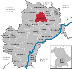
show Location of Nandlstadt within Freising district | |
 Nandlstadt | |
| Coordinates: 48°32′N 11°48′E / 48.533°N 11.800°ECoordinates: 48°32′N 11°48′E / 48.533°N 11.800°E | |
| Country | Germany |
| State | Bavaria |
| Admin. region | Oberbayern |
| District | Freising |
| Government | |
| • Mayor (2020–26) | Gerhard Betz[1] |
| Area | |
| • Total | 34.31 km2 (13.25 sq mi) |
| Elevation | 465 m (1,526 ft) |
| Population (2020-12-31)[2] | |
| • Total | 5,312 |
| • Density | 150/km2 (400/sq mi) |
| Time zone | UTC+01:00 (CET) |
| • Summer (DST) | UTC+02:00 (CEST) |
| Postal codes | 85405 |
| Dialling codes | 08756 |
| Vehicle registration | FS |
| Website | www.markt-nandlstadt.de |


Nandlstadt is a municipality in the district of Freising in Bavaria in Germany. Nandlstadt is said to be the oldest hop-growing area in the world, having grown them since the year 860. The town lies in a triangle between Freising, Moosburg and Mainburg.
References[]
- ^ Liste der ersten Bürgermeister/Oberbürgermeister in kreisangehörigen Gemeinden, Bayerisches Landesamt für Statistik, 15 July 2021.
- ^ "Tabellenblatt "Daten 2", Statistischer Bericht A1200C 202041 Einwohnerzahlen der Gemeinden, Kreise und Regierungsbezirke". Bayerisches Landesamt für Statistik (in German). June 2021.
| show Towns and municipalities in Freising (district) |
|---|
| Authority control |
|---|
This Freising district location article is a stub. You can help Wikipedia by . |
Categories:
- Municipalities in Bavaria
- Freising (district)
- Upper Bavaria geography stubs