New Boston, Ohio
New Boston, Ohio | |
|---|---|
 Location of New Boston, Ohio | |
 Location of New Boston in Scioto County | |
| Coordinates: 38°45′11″N 82°56′9″W / 38.75306°N 82.93583°WCoordinates: 38°45′11″N 82°56′9″W / 38.75306°N 82.93583°W | |
| Country | United States |
| State | Ohio |
| County | Scioto |
| Government | |
| • Mayor | William Williams Jr. |
| Area | |
| • Total | 1.15 sq mi (2.97 km2) |
| • Land | 1.12 sq mi (2.91 km2) |
| • Water | 0.02 sq mi (0.06 km2) |
| Elevation | 512 ft (156 m) |
| Population | |
| • Total | 2,272 |
| • Estimate (2019)[5] | 2,099 |
| • Density | 1,870.77/sq mi (722.12/km2) |
| Time zone | UTC-5 (Eastern (EST)) |
| • Summer (DST) | UTC-4 (EDT) |
| ZIP code | 45662 |
| Area code(s) | 740 |
| FIPS code | 39-54166[4] |
| GNIS feature ID | 1056446[3] |
| Website | www |

New Boston is a village in Scioto County, Ohio, United States, along the Ohio River. The population was 2,272 at the 2010 census.[6] Apart from its southern boundary on the Ohio River, New Boston is entirely surrounded by the city of Portsmouth.
New Boston is served by the Portsmouth Public Library and the New Boston Local School District.
History[]
New Boston was platted on February 17, 1891, by James Skelton, A.T. Holcomb, and M. Stanton.[7] The village was named after Boston, Massachusetts, the native home of a share of the first settlers.[8]
Geography[]
New Boston is located at 38°45′11″N 82°56′9″W / 38.75306°N 82.93583°W (38.753049, -82.935819).[9]
According to the United States Census Bureau, the village has a total area of 1.14 square miles (2.95 km2), of which 1.11 square miles (2.87 km2) are land and 0.03 square miles (0.08 km2) are water.[10]
New Boston is entirely surrounding on the west, north, and east by the City of Portsmouth and to the south by the Ohio River.
Demographics[]
| Historical population | |||
|---|---|---|---|
| Census | Pop. | %± | |
| 1870 | 111 | — | |
| 1910 | 1,858 | — | |
| 1920 | 4,817 | 159.3% | |
| 1930 | 5,931 | 23.1% | |
| 1940 | 6,024 | 1.6% | |
| 1950 | 4,734 | −21.4% | |
| 1960 | 3,984 | −15.8% | |
| 1970 | 3,325 | −16.5% | |
| 1980 | 3,188 | −4.1% | |
| 1990 | 2,717 | −14.8% | |
| 2000 | 2,340 | −13.9% | |
| 2010 | 2,272 | −2.9% | |
| 2019 (est.) | 2,099 | [5] | −7.6% |
| U.S. Decennial Census[11] | |||
2010 census[]
As of the census[2] of 2010, there were 2,272 people, 1,065 households, and 537 families living in the village. The population density was 2,046.8 inhabitants per square mile (790.3/km2). There were 1,173 housing units at an average density of 1,056.8 per square mile (408.0/km2). The racial makeup of the village was 96.0% White, 1.1% African American, 0.3% Native American, 0.3% Asian, 0.3% from other races, and 2.1% from two or more races. Hispanic or Latino of any race were 0.9% of the population.
There were 1,065 households, of which 27.8% had children under the age of 18 living with them, 26.4% were married couples living together, 19.5% had a female householder with no husband present, 4.5% had a male householder with no wife present, and 49.6% were non-families. 44.9% of all households were made up of individuals, and 20.9% had someone living alone who was 65 years of age or older. The average household size was 2.08 and the average family size was 2.91.
The median age in the village was 40.3 years. 22.7% of residents were under the age of 18; 8.2% were between the ages of 18 and 24; 23.2% were from 25 to 44; 26.3% were from 45 to 64; and 19.5% were 65 years of age or older. The gender makeup of the village was 45.8% male and 54.2% female.
2000 census[]
As of the census[4] of 2000, there were 2,340 people, 1,106 households, and 572 families living in the village. The population density was 2,114.4 people per square mile (813.9/km2). There were 1,248 housing units at an average density of 1,127.7 per square mile (434.1/km2). The racial makeup of the village was 97.74% White, 0.13% African American, 0.34% Native American, 0.09% Asian, 0.21% from other races, and 1.50% from two or more races. Hispanic or Latino of any race were 0.64% of the population.
There were 1,106 households, out of which 24.4% had children under the age of 18 living with them, 29.0% were married couples living together, 19.9% had a female householder with no husband present, and 48.2% were non-families. 44.1% of all households were made up of individuals, and 24.3% had someone living alone who was 65 years of age or older. The average household size was 2.06 and the average family size was 2.87.
In the village, the population was spread out, with 23.4% under the age of 18, 9.9% from 18 to 24, 23.3% from 25 to 44, 21.9% from 45 to 64, and 21.5% who were 65 years of age or older. The median age was 39 years. For every 100 females, there were 70.1 males. For every 100 females age 18 and over, there were 62.9 males.
The median income for a household in the village was $15,861, and the median income for a family was $25,036. Males had a median income of $23,158 versus $19,044 for females. The per capita income for the village was $13,810. About 28.2% of families and 32.2% of the population were below the poverty line, including 41.9% of those under age 18 and 24.0% of those age 65 or over.
Government[]
- William "Junior" Williams Jr. - Mayor
- Steve Hamilton - Village Administrator
- Jessica Grant - Clerk Of Courts
- Lana Loper- Clerk/Treasurer
- Theda Alderidge - Income Tax Director
- Justin Blume - Solicitor
- Robert C. Davis- Chief of Fire
- Steven Goins- Chief of Police
Village Council[]
- Dan Fetty
- Jon Mills
- Ralph Imes
- Ryan Ottney
- Mike Meehan
- Corey Jones
Notable people[]
- Ron Giles (television executive), born 1942, an award-winning American television executive and an author[12]
- Vern Riffe (1925-1997), Speaker of the Ohio House of Representatives
See also[]
- List of cities and towns along the Ohio River
Gallery[]
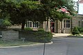
New Boston (Vern Riffe) Branch of the Portsmouth Public Library
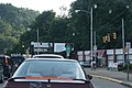
U.S. 52 & SR 139 intersection in New Boston. The Greater Portsmouth Regional Airport is 10 miles (16 km) north of this location.
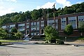
Glenwood High School (New Boston Local School District)


References[]
- ^ "2019 U.S. Gazetteer Files". United States Census Bureau. Retrieved July 28, 2020.
- ^ Jump up to: a b "U.S. Census website". United States Census Bureau. Retrieved 2013-01-06.
- ^ Jump up to: a b "US Board on Geographic Names". United States Geological Survey. 2007-10-25. Retrieved 2008-01-31.
- ^ Jump up to: a b "U.S. Census website". United States Census Bureau. Retrieved 2008-01-31.
- ^ Jump up to: a b "Population and Housing Unit Estimates". United States Census Bureau. May 24, 2020. Retrieved May 27, 2020.
- ^ "Profile of General Population and Housing Characteristics: 2010 Demographic Profile Data (DP-1): New Boston village, Ohio". United States Census Bureau. Retrieved March 29, 2012.
- ^ "Portsmouth Area Resource Guide, 2007-2008". The Community Common. 2007-07-29. p. 7.
- ^ Overman, William Daniel (1958). Ohio Town Names. Akron, OH: Atlantic Press. p. 96.
- ^ "US Gazetteer files: 2010, 2000, and 1990". United States Census Bureau. 2011-02-12. Retrieved 2011-04-23.
- ^ "US Gazetteer files 2010". United States Census Bureau. Archived from the original on 2012-01-25. Retrieved 2013-01-06.
- ^ "Census of Population and Housing". Census.gov. Retrieved June 4, 2015.
- ^ "Cable Innovator Hails". The Community Common. Portsmouth, Ohio. April 14, 1996. pp. 1A, 6E.
External links[]
| show Municipalities and communities of Scioto County, Ohio, United States |
|---|

| show Authority control |
|---|
- Villages in Scioto County, Ohio
- Villages in Ohio
- Ohio populated places on the Ohio River