Parliamentary constituency in the United Kingdom, 1983 onwards
This article uses bare URLs, which may be threatened by link rot. Please consider converting them to full citations to ensure the article remains verifiable and maintains a consistent citation style. Several templates and tools are available to assist in formatting, such as reFill (documentation).(May 2021) (Learn how and when to remove this template message)
A single-seat constituency of this name has existed since the 1983 general election. An earlier two-seat constituency of the same name was created by the Great Reform Act for the 1832 general election, when the former Durham constituency was split into two northern and southern divisions. Elections were held using the bloc vote system.
Boundaries[]
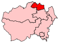
Map of current boundaries
Form 1832-1868 and this area was left intact until 1885. Extract from 1837 result: the shorter 'doubly' orange area which has an east coast.
1983–1997: The District of Chester-le-Street, and the District of Derwentside wards of Annfield Plain, Burnopfield, Catchgate, Craghead, Dipton, Havannah, South Moor, South Stanley, Stanley Hall, and Tanfield.
1997–2010: The District of Chester-le-Street, and the District of Derwentside wards of Annfield Plain, Catchgate, Craghead, Havannah, South Moor, South Stanley, Stanley Hall, and Tanfield. Burnopfield and Dipton wards were transferred to the redrawn North West Durham.
2010–present: The District of Chester-le-Street, and the District of Derwentside wards of Annfield Plain, Catchgate, Craghead and South Stanley, Havannah, South Moor, Stanley Hall, and Tanfield. The 1997 boundaries were retained despite the official description of the constituency changing slightly in terms of names of the wards of the seat.
^A county constituency (for the purposes of election expenses and type of returning officer)
^As with all constituencies, the constituency elects one Member of Parliament (MP) by the first past the post system of election at least every five years.