Nubra
This article needs additional citations for verification. (May 2016) |
Nubra | |
|---|---|
region | |
 Nubra Valley with Diskit Gompa and town immediately below and Hunder in the distance | |
 Nubra Location in Ladakh, India | |
| Coordinates: 34°36′N 77°42′E / 34.6°N 77.7°ECoordinates: 34°36′N 77°42′E / 34.6°N 77.7°E | |
| Country | |
| Union Territory | Ladakh |
| District | Leh |
| Time zone | UTC+5:30 (IST) |


Nubra is a subdivision and a tehsil in the Indian union territory of Ladakh. Its inhabited areas form a tri-armed valley cut by the Nubra and Shyok rivers. Its Tibetan name Ldumra means "the valley of flowers".[1] Demands have been raised and BJP has hinted at creation of Nubra as a new district.[2] Diskit, the headquarters of Nubra, is 120 km north from Leh, the capital of Ladakh.
The Shyok River meets the Nubra River (or Siachan River) to form a large valley that separates the Ladakh and Karakoram Ranges. The Shyok river is a tributary of the Indus river. The average altitude of the valley is more than 10,000 feet (3,000 m) above the sea level. The common way to access this valley is to travel over the Khardung La pass from Leh.
Foreign nationals are required to get a Protected area permit to visit Nubra. Since 1 April 2017 Indian citizens are also required to get an Inner Line Permit to visit it.[3]
Name[]
Nubra means "western" in Ladakhi, thus referring to the "western valley", perhaps distinguishing it from the eastern Shyok river valley, which is thinly populated. The traditional name of the region is Dumra, meaning the "valley of flowers".[1]
Geography[]

Alexander Cunningham listed Nubra as one of the five natural and historical divisions of Ladakh.[4] Nubra occupies the northeastern portion of Ladakh, bordering Baltistan and Chinese Turkestan in the north, and the Aksai Chin plateau and Tibet in the east. In Cunningham's conception, Nubra includes all the region drained by the Nubra and Shyok rivers. it is 128 miles long and 72 miles wide, making up an area of 9,200 square miles. It extends south till the Pangong Lake.[5]
In modern nomenclature, the Nubra region is divided into "Diskit Nubra" in the north and the "Darbuk region" in the south, both of which are regarded as tehsils and subdivisions of the Leh district.[6] The Diskit Nubra region includes the Turtuk region that was captured from Pakistan during the Indo-Pakistani War of 1971 and the Siachen Glacier region.[7]
The populated part of Nubra is often described as a "tri-armed valley",[8] the three arms being:[9]
- the Nubra River Valley (divided into three sections called Yarma, Tśurka and Farka),[a]
- Gyen, the upper Shyok valley from its southern bend till the confluence with the Nubra River, and
- Shama, the lower Shyok valley from the confluence till the Chorbat area.[9]
The eastern Shyok valley is mostly unpopulated, even though it has numerous camping sites that have been used by trade caravans. Murgo is a village on the tributary called Murgo Nala.
Topography[]

Like the rest of the Tibetan Plateau, Nubra is a high altitude cold desert with rare precipitation and scant vegetation except along river beds. The villages are irrigated and fertile, producing wheat, barley, peas, mustard and a variety of fruits and nuts, including blood apples, walnuts, apricots and even a few almond trees. Most of Nubra is inhabited by Nubra dialect or Nubra Skat speakers. The majority are Buddhists. In the western or lowest altitude end of Nubra near the Line of Control i.e. the Indo-Pak border, along the Shyok River, the inhabitants in village turtuk are Balti of Gilgit-Baltistan, who speak Balti, and are Shia and Sufia Nurbakhshia Muslims.
Siachen Glacier lies to the north of the valley. The Sasser Pass and the famous Karakoram Pass lie to the northwest of the valley and connect Nubra with Uyghur (Mandarin : Xinjiang). Previously there was much trade passing through the area with western China's Xinjiang and Central Asia. The people of Baltistan also used the Nubra valley for passage to Tibet.[10]
Places[]
Diskit town in the valley have become the congregation centre for people of the region. Diskit is the headquarters of Nubra and thus has lot of government offices with basic facilities. It is also connected by road with Leh.
Along the Nubra or Siachan River lie the villages of Sumur, Kyagar (called Tiger Hill by the Indian Army), , Panamik, Turtuk and many others.
Travel routes[]

The main road access to Nubra is over Khardung La pass which is open throughout the year. Its status as the highest motorable road in the world is no longer accepted by most authorities. An alternative route, opened in 2008, crosses the from Sakti, to the east of Khardung La, connecting to the main Nubra road system via and Khalsar along the Shyok River. There are also trekkable passes over the Ladakh Range from the Indus Valley at various points. Routes from Nubra to Baltistan and Yarkand, though historically important, have been closed since 1947 and 1950 respectively.
Tourism[]

The Nubra valley was open for tourists up to Hunder (the land of sand dunes) until 2010. The region beyond Hunder gives way to a greener region of Ladakh because of its lower altitude. The village of Turtuk which was unseen by tourists till 2010 is a virgin destination for people who seek peace and an interaction with a tribal community of Ladakh. The local tribe, Balti people, follows its age old customs in their lifestyle and speak a language which is just spoken and not written. For tourists Turtuk offers serene camping sites with environment friendly infrastructure.
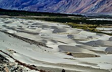
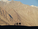
Panamik is noted for its hot springs. Between Hundar and Diskit lie several kilometres of sand dunes, and (two-humped) Bactrian camels graze in the neighbouring "forests" of seabuckthorn. Non-locals are not allowed below Hundar village into the Balti area, as it is a border area.
Monasteries[]

The 32 metre Maitreya Buddha statue is the landmark of Nubra and is maintained by the Diskit Monastery. On the Shyok (pronounced Shayok) River, the main village, Diskit, is home to the dramatically positioned Diskit Monastery which is built in 1420 AD. Hundar was the capital of the erstwhile Nubra kingdom in the 17th century, and is home to the Chamba Gompa.
Ganden Sumtseling Monastery is between Kyagar and Sumur villages. Across the Nubra or Siachan River at Panamik, is the isolated Ensa Gompa near Warisfistan village.
Flora and fauna[]
The valley is famous for its forest of Hippophae shrub, popularly known as Leh Berry. It is within this shrub forest that one can spot the white-browed tit-warbler. One can also spot the Tibetan lark, Hume's short-toed lark, and Hume's whitethroat. The various water birds like ruddy shelduck, garganey, northern pintail, and mallard can be observed on several small water bodies scattered along the route. Besides these, waders like black-tailed godwit, common sandpiper, common greenshank, common redshank, green sandpiper, and ruff can be spotted in Nubra.[11]
Education[]
The valley has been secluded as has been most of the exterior parts of Ladakh. Almost all of the region has been facing problems to get good quality education. There have been initiatives in the past by the government but extreme weather conditions and vicinity to the borders have been a major hurdle in implementing a solid education base. There is also migration of the population that gets exposed to the big cities of India and hence the people do not get benefitted out of their local learned population. There are very few Non-Government organizations active in Nubra region.
Gallery[]

A panoramic view over the Nubra

Local map with North towards down
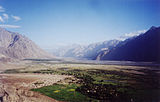
View from Diskit gompa on Nubra Valley

Seabuckthorn berries, Nubra valley, Ladakh

Bactrian camels
Silhoutte taken at Nubra Valley
This is enroute town called Hunder in Nubra.

Nubra Valley with Diskit Gompa and town immediately below and Hunder in the distance

Resort in Nubra Valley


See also[]
- Ladakh
- Khardung La
- Siachen Glacier
- Thoise
- Chalunka
- Project HIMANK, road builders in the valley and creators of curious sign boards
- Disket
Notes[]
- ^ Yarma is the upper part of the valley above Panamik, Tsurka is the right bank of the valley below Panamik, while Yarma is the left bank.
References[]
- ^ Jump up to: a b Kapadia, Harish (1999). Across Peaks & Passes in Ladakh, Zanskar & East Karakoram. Indus Publishing. p. 230. ISBN 978-81-7387-100-9.
- ^ 3,000 Demonstrate for Separate District in Sub-Zero Temperatures at Kargil, The Wire, 06/FEB/2020.
- ^ People, Attractions & Transportation in Nubra Valley, The Off: Leh Ladakh XP (Jai Kishan), 17 March 2021.
- ^ Cunningham, Ladak (1854), p. 18: "The natural divisions of the country are: 1st, Nubra on the Shayok; 2nd, Ladak Proper, on the Indus; 3rd, Zanskar, on the Zanskar river; 4th, Rukchu [Rupshu], around the lakes of Tshomo Riri [Tso Moriri] and Tsho-Kar; 5th, Purik, Suru, and Dras, on the different branches of the Dras river; 6th, Spiti, on the Spiti river: and 7th, Lahul, on the Chandra and Bhaga, or head-waters of the Chenab. These also are the actual divisions of the country, for the natural boundaries of a mountainous district generally remain unaltered, in spite of the changes wrought by war and religion. Ladak is divided politically between Maharaja Gulab Sing and the East-India Company. To the former belong all the northern districts, to the latter only the two southern districts of Lahul and Spiti."
- ^ Cunningham, Ladak (1854), p. 21.
- ^ Tehsil, Leh district administration, retrieved 15 November 2020.
- ^ Muhammad Raafi, Interview of Delan Namgial, Kashmiri Life, 17 January 2017.
- ^ Sumedha Das, Paradise on Earth, The Statesman, 24 November 2019.
- ^ Jump up to: a b Vohra, Mythic Lore from Nubra Valley (1990), pp. 225–226.
- ^ Senge H. Sering, “Reclaiming Nubra” – Locals Shunning Pakistani Influences Archived 8 July 2016 at the Wayback Machine, Institute for Defence Studies and Analyses, Delhi, 17 August 2009.
- ^ Khan, Asif (2016). "Ladakh: The Land Beyond". Buceros. 21 (3): 6–15.
Bibliography[]
- Cunningham, Alexander (1854), Ladak: Physical, Statistical, Historical, London: Wm. H. Allen and Co – via archive.org
- Francke, Rev. A. H. (1907), A History of Western Tibet, S. W. Partridge & Co – via archive.org
- Longstaff, T. G. (June 1910), "Glacier Exploration in the Eastern Karakoram", The Geographical Journal, The Royal Geographical Society, 35 (6): 622–653, doi:10.2307/1777235, JSTOR 1777235
- Shakabpa, Tsepon Wangchuk Deden (2009), One Hundred Thousand Moons: An Advanced Political History of Tibet, BRILL, ISBN 978-90-04-17732-1
- Shakspo, Nawang Tsering (1999), "The Foremost Teachers of the Kings of Ladakh", in Martijn van Beek; Kristoffer Brix Bertelsen; Poul Pedersen (eds.), Recent Research on Ladakh 8, Aarhus University Press, pp. 284–, ISBN 978-87-7288-791-3
- Thomson, Thomas (1852), Western Himalaya and Tibet: A Narrative of a Journey Through the Mountains of Northern India, During the Years 1847-8, Reeve and Company – via archive.org
- Vohra, Rohit (1990), "Mythic Lore and Historical Documents from Nubra Valley in Ladakh", Acta Orientalia Academiae Scientiarum Hungaricae, Akadémiai Kiadó, 44 (1/2): 225–239, JSTOR 23658122
External links[]
| Wikimedia Commons has media related to Nubra Valley. |
| Wikivoyage has a travel guide for Nubra Valley. |
| show |
|---|
| show Authority control |
|---|
- Valleys of Ladakh
- Indus basin
- Karakoram