Oberkrämer
Oberkrämer | |
|---|---|
 Church in Vehlefanz | |
 Coat of arms | |
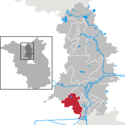
show Location of Oberkrämer within Oberhavel district | |
 Oberkrämer | |
| Coordinates: 52°42′N 13°06′E / 52.700°N 13.100°ECoordinates: 52°42′N 13°06′E / 52.700°N 13.100°E | |
| Country | Germany |
| State | Brandenburg |
| District | Oberhavel |
| Subdivisions | 7 districts |
| Government | |
| • Mayor (2015–23) | Peter Leys[1] |
| Area | |
| • Total | 103.67 km2 (40.03 sq mi) |
| Elevation | 54 m (177 ft) |
| Population (2020-12-31)[2] | |
| • Total | 11,833 |
| • Density | 110/km2 (300/sq mi) |
| Time zone | UTC+01:00 (CET) |
| • Summer (DST) | UTC+02:00 (CEST) |
| Postal codes | 16727 |
| Dialling codes | 03304 |
| Vehicle registration | OHV |
| Website | www.oberkraemer.de |


Oberkrämer is a municipality in the Oberhavel district, in Brandenburg, Germany. An experimental farm of wind turbines existed between 1941 and 1945 on the 50 m high in the area.
Subdivisions[]
Oberkrämer consists of formerly separate municipalities, which as of 31 December 2001 merged with the new municipality of Oberkrämer.
Demography[]
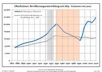
Development of population since 1875 within the current Boundaries (Blue Line: Population; Dotted Line: Comparison to Population development in Brandenburg state; Grey Background: Time of Nazi Germany; Red Background: Time of communist East Germany)
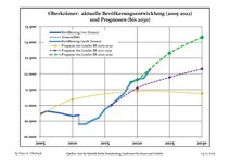
Recent Population Development and Projections (Population Development before Census 2011 (blue line); Recent Population Development according to the Census in Germany in 2011 (blue bordered line); Official projections for 2005-2030 (yellow line); for 2020-2030 (green line); for 2017-2030 (scarlet line)


|
|
|
Photogallery[]
- Schwante

Manor

Park

Former water tower


References[]
- ^ Landkreis Oberhavel Wahl der Bürgermeisterin / des Bürgermeisters, accessed 2 July 2021.
- ^ "Bevölkerung im Land Brandenburg nach amtsfreien Gemeinden, Ämtern und Gemeinden 31. Dezember 2020". Amt für Statistik Berlin-Brandenburg (in German). June 2021.
- ^ Detailed data sources are to be found in the Wikimedia Commons.Population Projection Brandenburg at Wikimedia Commons
External links[]
![]() Media related to Oberkrämer at Wikimedia Commons
Media related to Oberkrämer at Wikimedia Commons
| Authority control |
|---|
This Brandenburg location article is a stub. You can help Wikipedia by . |
- Municipalities in Brandenburg
- Localities in Oberhavel
- Province of Brandenburg
- Bezirk Potsdam
- Brandenburg geography stubs