Oiry
show This article may be expanded with text translated from the corresponding article in French. (July 2014) Click [show] for important translation instructions. |
Oiry | |
|---|---|
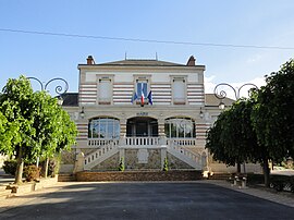 The town hall of Oiry | |
 Coat of arms | |
show Location of Oiry | |
 Oiry | |
| Coordinates: 49°01′28″N 4°03′04″E / 49.0244°N 4.0511°ECoordinates: 49°01′28″N 4°03′04″E / 49.0244°N 4.0511°E | |
| Country | France |
| Region | Grand Est |
| Department | Marne |
| Arrondissement | Épernay |
| Canton | Épernay-2 |
| Intercommunality | Épernay, Coteaux et Plaine de Champagne |
| Government | |
| • Mayor (2020–2026) | Dominique Charlot[1] |
| Area 1 | 10.76 km2 (4.15 sq mi) |
| Population (Jan. 2018)[2] | 832 |
| • Density | 77/km2 (200/sq mi) |
| Time zone | UTC+01:00 (CET) |
| • Summer (DST) | UTC+02:00 (CEST) |
| INSEE/Postal code | 51413 /51530 |
| 1 French Land Register data, which excludes lakes, ponds, glaciers > 1 km2 (0.386 sq mi or 247 acres) and river estuaries. | |


Oiry is a commune in the Marne department in north-eastern France.
Champagne[]
The village's vineyards are located in the Côte de Blancs subregion of Champagne, and are classified as Grand Cru (100%) in the Champagne vineyard classification.
See also[]
References[]
- ^ "Répertoire national des élus: les maires". data.gouv.fr, Plateforme ouverte des données publiques françaises (in French). 2 December 2020.
- ^ "Populations légales 2018". INSEE. 28 December 2020.
| Wikimedia Commons has media related to Oiry. |
This Marne geographical article is a stub. You can help Wikipedia by . |
Categories:
- Communes of Marne (department)
- Grand Cru Champagne villages
- Marne (department) geography stubs