Ojiya, Niigata
This article needs additional citations for verification. (March 2013) |
Ojiya
小千谷市 | |
|---|---|
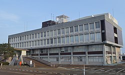 Ojiya City Hall | |
 Flag  Seal | |
 Location of Ojiya in Niigata | |
 Ojiya | |
| Coordinates: 37°18′51.7″N 138°47′42.3″E / 37.314361°N 138.795083°ECoordinates: 37°18′51.7″N 138°47′42.3″E / 37.314361°N 138.795083°E | |
| Country | Japan |
| Region | Chūbu (Kōshin'etsu) (Hokuriku) |
| Prefecture | Niigata |
| Area | |
| • Total | 155.19 km2 (59.92 sq mi) |
| Population (July 1, 2019) | |
| • Total | 34,704 |
| • Density | 220/km2 (580/sq mi) |
| Time zone | UTC+9 (Japan Standard Time) |
| Symbols | |
| • Flower | Narcissus |
| • Fish | Japanese carp |
| Phone number | 0250-62-2510 |
| Address | 2-7-5 Jonai, Ojiya-shi, Niigata-ken 947-8501 |
| Website | Official website |

Ojiya (小千谷市, Ojiya-shi) is a city located in Niigata Prefecture, Japan. As of 1 July 2019, the city had an estimated population of 34,704 in 12,758 households,[1] and a population density of 224 persons per km². The total area of the city was 155.19 square kilometres (59.92 sq mi).
Geography[]
Ojiya is located in an inland region of central Niigata Prefecture at the southern end of the Echigo Plain. The Shinano River flows through the city. The area has very heavy snow in winter.

Surrounding municipalities[]
- Niigata Prefecture
- Nagaoka
- Uonuma
- Tokamachi
Climate[]
Ojiya has a Humid climate (Köppen Cfa) characterized by warm, wet summers and cold winters with heavy snowfall. The average annual temperature in Ojiya is 12.6 °C. The average annual rainfall is 2263 mm with September as the wettest month. The temperatures are highest on average in August, at around 25.8 °C, and lowest in January, at around 0.5 °C.[2]
Demographics[]
Per Japanese census data,[3] the population of Ojiya has declined steadily over the past 40 years.
| Census Year | Population |
|---|---|
| 1970 | 44,581 |
| 1980 | 44,963 |
| 1990 | 43,437 |
| 2000 | 41,641 |
| 2010 | 38,600 |
History[]
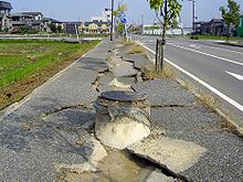
The area of present-day Ojiya was part of ancient Echigo Province. During the Edo period, the area was largely tenryō territory administered directly by the Tokugawa shogunate nd developed as a rive report on the Shinano River. The area was traditionally noted for its Ojiya chijimi, a type of linen fabric. After the Meiji restoration, the area was organised as part of Kitauonuma District, Niigata and the town of Ojiya was established with the creation of the modern municipalities system on April 1, 1889. It was raised to city status on March 10, 1954. On October 23, 2004, the Chūetsu earthquake struck Ojiya, causing shaking measured at Intensity 6+ on the Japan Meteorological Agency seismic intensity scale and causing fatalities. Electricity was cut off for three days after the earthquake.
Government[]
Ojiya has a mayor-council form of government with a directly elected mayor and a unicameral city legislature of 16 members.
Economy[]

Ojiya is known for the birthplace of Nishikigoi carps, along with Yamakoshi.
Education[]
Ojiya has eight public elementary schools and five public middle schools operated by the city government. There are two public high schools operated by the Niigata Prefectural Board of Education, and the prefecture also operates one special education school.
Transportation[]

Railway[]
 JR East - Jōetsu Line
- JR East - Iiyama Line
Highway[]
 Kan-Etsu Expressway – Ojiya IC
 National Route 17
 National Route 117
 National Route 291
 National Route 351
 National Route 403
Local attractions[]


- Ojiya Balloon Festival
- Katakai Fireworks Festival
- Ojiya Nishikigoi no sato
Notable people from Ojiya[]
- Uchiyama Gudō, Zen priest and anarcho-socialist activist
- Junzaburō Nishiwaki, poet
References[]
External links[]
| Wikimedia Commons has media related to Ojiya, Niigata. |
- Official Website (in Japanese)
| show Authority control |
|---|
- Ojiya, Niigata
- Cities in Niigata Prefecture