Oneida, Kentucky
Oneida | |
|---|---|
Census-designated place (CDP) | |
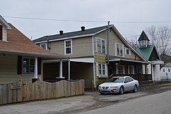 Buildings along River Street | |
 Oneida Location within the state of Kentucky | |
| Coordinates: 37°16′10″N 83°38′57″W / 37.26944°N 83.64917°WCoordinates: 37°16′10″N 83°38′57″W / 37.26944°N 83.64917°W | |
| Country | United States |
| State | Kentucky |
| County | Clay |
| Area | |
| • Total | 2.096 sq mi (5.43 km2) |
| • Land | 2.043 sq mi (5.29 km2) |
| • Water | 0.053 sq mi (0.14 km2) |
| Elevation | 778 ft (237 m) |
| Population | |
| • Total | 410 |
| • Density | 200/sq mi (76/km2) |
| Time zone | UTC-5 () |
| • Summer (DST) | UTC-4 (EST) |
| GNIS feature ID | 514357[3] |


Oneida is an unincorporated community and census-designated place (CDP) in Clay County, Kentucky, United States. Its population was 410 at the 2010 census.[2] It is the home of Oneida Baptist Institute. Goose Creek, the Red Bird River, and Bullskin Creek confluence to form the South Fork of the Kentucky River a few hundred yards from the center of the town.
The major road that leads from the center of town to the Leslie County line is called "Bullskin".
Climate[]
The climate in this area is characterized by hot, humid summers and generally mild to cool winters. According to the Köppen Climate Classification system, Oneida has a humid subtropical climate, abbreviated "Cfa" on climate maps.[4]
References[]
- ^ "US Gazetteer files: 2010, 2000, and 1990". United States Census Bureau. 2011-02-12. Retrieved 2011-04-23.
- ^ Jump up to: a b "U.S. Census website". United States Census Bureau. Retrieved 2011-05-14.
- ^ U.S. Geological Survey Geographic Names Information System: Oneida, Kentucky
- ^ Climate Summary for Oneida, Kentucky
External links[]
| show Municipalities and communities of Clay County, Kentucky, United States |
|---|

| show Authority control |
|---|
This Clay County, Kentucky state location article is a stub. You can help Wikipedia by . |
- Census-designated places in Clay County, Kentucky
- Unincorporated communities in Clay County, Kentucky
- Unincorporated communities in Kentucky
- Census-designated places in Kentucky
- Clay County, Kentucky geography stubs