Iloilo City Proper
City Proper
Downtown Ciudad Poblacion Iloilo | |
|---|---|
Iloilo City District | |
| Iloilo City Proper | |
      From upper-left to right, middle-left to right and bottom-left to right: Edificio de Villanueva; Ayuntamiento de Iloilo (Iloilo City Hall); UPV Art Gallery (Old Iloilo City Hall); Serafin Javellana; Aduana de Iloilo (Iloilo Customs House); Casa Real de Iloilo (Old Iloilo Provincial Capitol) | |
| Nickname(s): "Center of Iloilo City", "Heart of Iloilo" | |
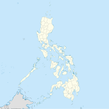
 Map of Iloilo City, Philippines with the District of City Proper in green color. | |
 City Proper Location in the Philippines | |
| Coordinates: 10°41′42.7194″N 122°33′52.92″E / 10.695199833°N 122.5647000°E | |
| Country | |
| Region | Western Visayas (Region VI) |
| Province | Iloilo (geographically only) |
| City | Iloilo City |
| Established | 1602 as La Punta (settlement by the Spanish colonists) |
| Cityhood | 1890 (cityhood during Spanish colonial regime) |
| Reincorporation | July 16, 1937 |
| Barangays | 45 (see Barangays) |
| Government | |
| • Mayor | Geronimo "Jerry" P. Trenas (Mayor of Iloilo City) |
| Area | |
| • Total | 3.75 km2 (1.45 sq mi) |
| Population (2020 census) | |
| • Total | 46,350 |
| • Density | 12,360/km2 (32,000/sq mi) |
| Demonym(s) | Taga-Ciudad Ilonggo (masculine) Ilongga (feminine) |
| Time zone | UTC+8 (Philippine Standard Time) |
| ZIP code | 5000 |
| Area code(s) | 33 |
| Patron saint | Santo Niño (district patronal saint) |
| Feast day | Fourth Sunday of January in honor of Señor Santo Niño or Holy Child Jesus (coincides with Dinagyang Festival) |
| Language(s) | Hiligaynon (Ilonggo), Filipino, English |
| Website | www |

Iloilo City Proper (City Proper) (simply known as Downtown, Ciudad, Iloilo Poblacion or Iloilo) (Hiligaynon/Ilonggo: Poblacion sang Iloilo), is one of the seven districts also known as the center or heart of Iloilo City. It received its present name from the province's original Irong-Irong reference. It was founded as La Punta and inhabited in 1602 when Spanish and Chinese residents from Jaro and Molo expanded their territorial area. During its heyday, it was called Yloylo or Iloilo.[1] It is home to the Old Iloilo Downtown CBD and Heritage Center (City Proper Central Business District and Heritage Center).[2]
History[]
The town was once invaded by the Dutch in the 17th century, who were later driven away, and later emerged as a trading port in the 19th century. Its geographical and economic significance eventually evolved when China, Norway and the United Kingdom opened up their consulates to conduct trade and commerce in the town, especially during its foundation as an international port in the 1850s.
Plaza Libertad, the city's historical square, was the site where the Philippine flag was raised for the first time in the island of Panay on December 25, 1898 during the Philippine Revolution when local troops led by Gen. Martin Delgado defeated the Spanish army.
In the 20th century, all economic activities shifted from Jaro and Molo to the town of Iloilo when businesses aggressively flourished here. It was later transformed into a chartered city and absorbed the old towns of Molo, Arevalo, Mandurriao and La Paz as well the city of Jaro.
Main sights[]
The district is the home to the main government building of the Province of Iloilo, the Iloilo provincial capital and the seat of the city government, the Iloilo City Hall. Other main agencies of the government is also located at the city proper. Its main thoroughfares are J.M. Basa St. (Calle Real), Iznart St., Gen. Luna St. and Ledesma St. It has the most service and commercial establishments among all districts.
Barangays[]
Iloilo City Proper has the most barangays in Iloilo City with a total of 45 barangays. City Proper is the second most densely populated Iloilo City district with a population density of 12,435 people per square kilometer.
| Barangays | Population (2020) | Area (km²) | Pop. density (per km²) |
|---|---|---|---|
| Arsenal Aduana | 170 | 0.08 | 2,199 |
| Baybay Tanza | 2,106 | 0.25 | 8,275 |
| Bonifacio Tanza | 2,881 | 0.04 | 67,282 |
| Concepcion-Montes | 2,550 | 0.22 | 11,559 |
| Danao | 278 | 0.20 | 1,397 |
| Delgado-Jalandoni-Bagumbayan | 218 | 0.02 | 9,281 |
| Edganzon | 360 | 0.10 | 3,482 |
| Flores | 187 | 0.04 | 4,884 |
| General Hughes-Montes | 1,895 | 0.09 | 20,849 |
| Gloria | 138 | 0.02 | 5,857 |
| Hipodromo | 629 | 0.05 | 11,746 |
| Inday | 234 | 0.15 | 1,594 |
| Jalandoni-Wilson | 827 | 0.06 | 13,749 |
| Kahirupan | 443 | 0.03 | 14,826 |
| Kauswagan | 386 | 0.04 | 8,894 |
| Legaspi dela Rama | 764 | 0.12 | 6,536 |
| Liberation | 335 | 0.05 | 6,842 |
| Mabolo-Delgado | 1,044 | 0.05 | 19,920 |
| Magsaysay | 301 | 0.07 | 4,160 |
| Malipayon-Delgado | 752 | 0.02 | 30,619 |
| Maria Clara | 575 | 0.06 | 9,635 |
| Monica Blumentritt | 1,305 | 0.06 | 20,820 |
| Muelle Loney-Montes | 1,109 | 0.09 | 12,689 |
| Nonoy | 355 | 0.08 | 4,604 |
| Ortiz | 1,272 | 0.10 | 13,207 |
| Osmeña | 90 | 0.03 | 2,870 |
| President Roxas | 181 | 0.20 | 916 |
| Rima-Rizal | 633 | 0.01 | 44,894 |
| Rizal Estanzuela | 3,215 | 0.04 | 91,465 |
| Rizal Ibarra | 560 | 0.03 | 19,257 |
| Rizal Palapala I | 1,699 | 0.02 | 84,654 |
| Rizal Palapala II | 2,228 | 0.03 | 79,543 |
| Roxas Village | 51 | 0.04 | 1,333 |
| Sampaguita | 355 | 0.13 | 2,632 |
| San Agustin | 516 | 0.19 | 2,729 |
| San Felix | 1,006 | 0.10 | 10,317 |
| San Jose | 231 | 0.03 | 7,591 |
| Santo Rosario-Duran | 1,608 | 0.11 | 14,019 |
| Tanza-Esperanza | 1,806 | 0.06 | 32,141 |
| Timawa Tanza I | 413 | 0.02 | 22,780 |
| Timawa Tanza II | 1,367 | 0.04 | 30,664 |
| Veterans Village | 5,373 | 0.23 | 23,050 |
| Villa Anita | 1,051 | 0.12 | 8,929 |
| Yulo-Arroyo | 155 | 0.04 | 4,149 |
| Zamora-Melliza | 2,698 | 0.15 | 17,519 |
| Total | 46,350 | 3.73 | 12,435 |
| Source: Iloilo City (Philippines): Barangays - Population Statistics, Charts and Map (citypopulation.de) https://www.citypopulation.de/en/philippines/iloilo/ | |||
Gallery[]

A scene at Iznart Street during a Chinese new year parade

Construction of the new Iloilo City Hall
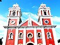
San José de Placer Church fronting Plaza Libertad
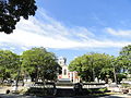
Plaza Libertad


See also[]
- Calle Real
- University of the Philippines Visayas - Iloilo City
- Dinagyang Festival
- Iloilo City
References[]
| Wikimedia Commons has media related to City Proper, Iloilo City. |
- ^ "Archived copy". Archived from the original on January 21, 2012. Retrieved February 20, 2012.
{{cite web}}: CS1 maint: archived copy as title (link) - ^ https://iloilocity.gov.ph/main/wp-content/uploads/2021/03/Vol1_CLUP-3-3-21-final-draft-1.pdf
External links[]
Coordinates: 10°41′43″N 122°33′53″E / 10.6952°N 122.5647°E
- Districts of Iloilo City