Ostrobothnia (region)
Ostrobothnia
| |
|---|---|
| Region of Ostrobothnia Landskapet Österbotten Pohjanmaan maakunta | |
 Coat of arms | |
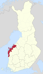 Ostrobothnia on a map of Finland | |
| Country | Finland |
| Historical province | Ostrobothnia |
| Capital | Vaasa |
| Area | |
| • Total | 7,932.36 km2 (3,062.70 sq mi) |
| Population (2019) | |
| • Total | 180,445 |
| • Density | 23/km2 (59/sq mi) |
| Time zone | UTC+2 (EET) |
| • Summer (DST) | UTC+3 (EEST) |
| ISO 3166 code | FI-12 |
| NUTS | 195 |
| Regional bird | Common swift (Apus apus) |
| Regional fish | Common whitefish (Coregonus lavaretus) |
| Regional flower | European meadowsweet (Filipendula ulmaria) |
| Website | osterbotten.fi |
Ostrobothnia (Swedish: Österbotten; Finnish: Pohjanmaa) is a region in western Finland. It borders the regions of Central Ostrobothnia, South Ostrobothnia, and Satakunta and is one of the four modern regions making up the historical province of Ostrobothnia. It is also referred to as Coastal Ostrobothnia to avoid confusion.
Ostrobothnia is one of the two Finnish regions with a Swedish-speaking majority (the other being the constitutionally monolingual province of Åland); Swedish-speakers make up 51.2%.[1] The region contains thirteen bilingual municipalities and one that is exclusively Finnish-speaking. The capital of Vaasa is predominantly inhabited by Finnish speakers, whereas smaller towns and rural areas are generally dominated by the Swedish language. The three most inhabited municipalities of that type are Korsholm, Jakobstad and Pedersöre.
Geographically, Ostrobothnia has little topographical relief, because it is mostly former seafloor brought to surface by post-glacial rebound and the accumulation of alluvial sediment. Ostrobothnia has both vast expanses of cultivated fields (lakeus) as in Southern Ostrobothnia, and the archipelago of Kvarken (Finnish: Merenkurkku). Glacial transport has deposited large quantities of rocks in the area.[2] Like elsewhere in Pohjanmaa, rivers are a prominent part of the landscape. The major rivers that discharge into the Gulf of Bothnia in Ostrobothnia are Kyrönjoki, and .
Kaskinen, a coastal town located in the southern part of the region, is the smallest town in Finland in terms of both area and population.[3]
Name and symbols[]
Prior to the officialization of the names of the Finnish regions, Ostrobothnia was also known as Vasa kustregionen in Swedish and Vaasan rannikkoseutu in Finnish, both of which translate into "[the] coastal region of Vaasa". The Institute for the Languages of Finland recommended that the region be named Kustösterbotten in Swedish and Rannikko-Pohjanmaa in Finnish, meaning "coastal Ostrobothnia" in English. However, upon the confirmation of the names of the Finnish regions on 26 February 1998, the current name of the region was officialized instead, according to the wishes of the regional government. The central government cited the Swedish language's prevalence in the region, as well as the lack of a common consensus on an alternative name the reasons for its decision.[4] In local circles or communities, Ostrobothnia is often referred to as "Pampas". The word derives from the similarities in the flat landscape with the Pampas area in South America.
The regional tree is the black alder (Alnus glutinosa), the regional mammal is the common elk (Alces alces), the regional stone is Vaasa granite and the regional song is "The march of Vaasa" (Swedish: Vasamarschen, Finnish: Vaasan marssi).
Coat of arms[]
Gules, a sheaf Or; on chief countercharged four ermines 2+2 courant.
The sprouting wheatsheaf is a symbol of the Royal House of Vasa; a Vasa king established the city of Vaasa, the capital of the region. The running stoats are a symbol of Ostrobothnia.
Municipalities and languages[]
The region of Ostrobothnia is made up of 14 municipalities, of which six have city status (marked in bold), and the links are only in the majority language names. The greater Vaasa region has about 40% Swedish native speakers and a Finnish majority, whereas the Jakobstad region has about 70% and the southern region about 57% Swedish speakers. The rural part of the Vaasa region has a sizeable Swedish-speaking majority, with the majority of native Finnish speakers in Ostrobothnia as a whole living in Vaasa city proper. Isokyrö is a former unilingually Finnish municipality of the region, but transferred to South Ostrobothnia in 2021.
Ostrobothnia is similar to German-speaking South Tyrol in Italy in that its capital has the majority language of the country as the mainly spoken one, but the region in general is having a different majority language to the nation as a whole. Other similar regions in Western Europe with a different main language compared to the country also see that reflected in the capitals. The main difference between the language statuses of Ostrobothnia and South Tyrol is that Swedish is official at governmental level in all of Finland, something that does not apply to German outside of the Tyrolean region.
| Name in Finnish |
Name in Swedish |
Population[5] | Swedish Speakers[6] |
Finnish Speakers[6] |
Sub-Region |
|---|---|---|---|---|---|
| Pietarsaari | Jakobstad | 19,098 | 56.4% | 40.2% | Jakobstad |
| Kaskinen | Kaskö | 1,283 | 28.1% | 68.1% | Sydösterbotten |
| Mustasaari | Korsholm | 19,481 | 70.2% | 28.7% | Vaasa |
| Korsnäs | Korsnäs | 2,066 | 91.2% | 3.2% | Vaasa |
| Kristiinankaupunki | Kristinestad | 6,405 | 56.6% | 42.2% | Sydösterbotten |
| Kruunupyy | Kronoby | 6,407 | 83.3% | 15.6% | Jakobstad |
| Laihia | Laihela | 7,985 | 1% | 98.3% | Kyrönmaa |
| Luoto | Larsmo | 5,536 | 92.5% | 6.5% | Jakobstad |
| Maalahti | Malax | 5,464 | 88.2% | 9.1% | Vaasa |
| Närpiö | Närpes | 9,583 | 88.4% | 5.8% | Sydösterbotten |
| Uusikaarlepyy | Nykarleby | 7,509 | 89.3% | 8.1% | Jakobstad |
| Pedersören kunta | Pedersöre | 11,187 | 90.1% | 9% | Jakobstad |
| Vaasa | Vasa | 67,447 | 24.8% | 69.8% | Vaasa |
| Vöyri | Vörå | [5] | 84.6% | 13.6% | Vaasa |
Former municipalities:
- The current Vörå is the result of consolidation of Maxmo and Oravais.
- Nykarleby has been merged with Jeppo, and .
- Korsholm has been consolidated from the five municipalities of Korsholm, , Replot, Björköby and Kvevlax.
- Vaasa has been merged with parts of Solf and Korsholm.
- Pedersöre has been merged with Esse and Purmo.
- Malax has been consolidated from the municipalities of Malax, Petalax, Bergö and the northern part of Pörtom.
- Närpes has been merged with Övermark and Pörtom.
- Kristinestad has been consolidated from Kristinestad, , and .
- Kronoby is consolidated from Kronoby, Nedervetil and Terjärv.
- Isokyrö is joined to the South Ostrobothnia region.
Climate[]
Ostrobothnia is located in the borderlands between the humid continental and subarctic climates (Köppen Dfb/Dfc). Its winters are moderated by prevailing westerly winds from the mild North Atlantic Current travelling across Norway, Sweden and the Bay of Bothnia. Although the sea tends to easily freeze over in winter during prolonged spells of cold weather due to the low salinity, winters seldom get severely cold.
In general during latter decades, the southern Bothnia Bay coastlines of central Norrland in Sweden across the strait and Ostrobothnia mostly range from slightly above 20 °C (68 °F) average highs in summer to about −3 °C (27 °F) highs and −10 °C (14 °F) lows in winter. Due to the vastness of the region from north to south, this will vary by a bit from one place to another depending on latitude.
Precipitation is quite variable but is enough to build up a reliable snowpack all through the region during winter months. In summer, Ostrobothnia experiences perpetual civil twilight due to its high latitude with the sun angle never falling below -3° at summer solstice in Vaasa and -2° in Jakobstad.[7][8] During that time of the year, daylight remains bright enough to permit daytime outdoor activities without artificial lighting especially under clear skies. As a result, days are short during winter although all areas of Ostrobothnia are far south of the Arctic Circle.
Politics[]
Results of the 2019 Finnish parliamentary election in Ostrobothnia:
- Swedish People's Party 47.23%
- Social Democratic Party 15.09%
- Finns Party 11.19%
- National Coalition Party 7.38%
- Christian Democrats 6.74%
- Centre Party 4.16%
- Left Alliance 3.54%
- Green League 3.51%
- Seven Star Movement 0.24%
- Blue Reform 0.20%
- Other parties 0.72%
Gallery[]
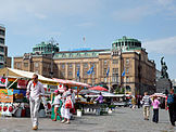
Vaasa Market Place with the "Statue of Liberty" on the right

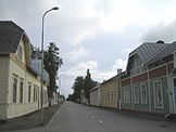
A street view from Kristinestad, one of the best preserved wooden towns in the Nordic Countries

A view towards Kvarken from Norrskär Lighthouse, Korsholm
A view of Jakobstad town from the water tower

Kristinestad Old Church from 1700

Kristinestad on the shores

An Ostrobothnian expanse in Laihia
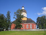
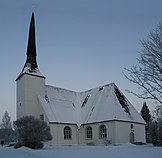
Larsmo Church

Church stables at Närpes Church

An old tobacco factory in Jakobstad

University of Vaasa Main Building
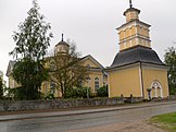
Kronoby Church

Jakobstad Town Hall
Vörå Church from 1626, oldest preserved wooden church in Finland
A street in Finland's smallest town Kaskinen with typical Jugendstil buildings in the foreground

A view from Nykarleby town

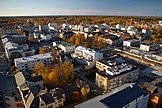
A view of City of Vaasa

Isokyrö Old Church from early 16th century
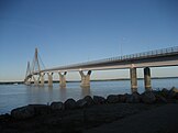
Replot Bridge, the longest bridge in Finland

There are daily ferry connections to Umeå, Sweden from Vaasa
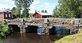
An old bridge in Korsnäs


See also[]
References[]
- ^ Väestö iän ja sukupuolen mukaan alueittain[permanent dead link] 31.12.2008. Tilastokeskus: demography.
- ^ "Aika, kallioperä ja jääkaudet » Merenkurkun saaristo". www.merenkurkku.fi. Retrieved 15 April 2018.
- ^ The Island Town of Artisans, Fishermen and Sailors – Visit Kaskinen
- ^ "Valtioneuvosto nimesi Suomen maakunnat". The Finnish Ministry of Internal Affairs (in Finnish). 26 February 1998. Archived from the original on 24 May 2011. Retrieved 22 September 2020.
- ^ Jump up to: a b "Preliminary population structure by area, 2021M01*-2021M03*". StatFin (in Finnish). Statistics Finland. Retrieved 2 May 2021.
- ^ Jump up to: a b "Population according to language and the number of foreigners and land area km2 by area as of 31 December 2008". Statistics Finland's PX-Web databases. Statistics Finland. Retrieved 29 March 2009.
- ^ "Sunrise and sunset times in Vaasan Lääni, June 2021". Timeanddate.com. Retrieved 9 January 2021.
- ^ "Sunrise and sunset times in Jakobstad, June". Timeanddate.com. Retrieved 9 January 2021.
External links[]
![]() Media related to Ostrobothnia at Wikimedia Commons
Media related to Ostrobothnia at Wikimedia Commons
Coordinates: 63°N 22°E / 63°N 22°E

| show Authority control |
|---|
- Ostrobothnia (region)
- Regions of Finland