Oudtshoorn Local Municipality
Oudtshoorn | |
|---|---|
 Seal | |
 Location in the Western Cape | |
| Coordinates: 33°40′S 22°10′E / 33.667°S 22.167°ECoordinates: 33°40′S 22°10′E / 33.667°S 22.167°E | |
| Country | South Africa |
| Province | Western Cape |
| District | Garden Route |
| Seat | Oudtshoorn |
| Wards | 13 |
| Government | |
| • Type | Municipal council |
| • Mayor | Chris MacPherson (DA) |
| Area | |
| • Total | 3,537 km2 (1,366 sq mi) |
| Population (2011)[2] | |
| • Total | 95,933 |
| • Density | 27/km2 (70/sq mi) |
| Racial makeup (2011) | |
| • Black African | 9.1% |
| • Coloured | 77.3% |
| • Indian/Asian | 0.3% |
| • White | 12.5% |
| First languages (2011) | |
| • Afrikaans | 91.0% |
| • Xhosa | 4.8% |
| • English | 2.3% |
| • Other | 1.9% |
| Time zone | UTC+2 (SAST) |
| Municipal code | WC045 |

Oudtshoorn Municipality (Afrikaans: Oudtshoorn Munisipaliteit) is a municipality located in the Western Cape Province of South Africa. As of 2011 the population was 95,933.[2]
Geography[]
The municipality covers an area of 3,537 square kilometres (1,366 sq mi) in the Little Karoo, stretching from the Swartberg mountains in the north to the Outeniqua Mountains in the south, and from the Gamkaberg in the west to the Kammanassie Mountains in the east. It abuts on the Prince Albert Municipality to the north, the George Municipality to the east, the Mossel Bay Municipality to the south, the Hessequa Municipality to the southwest and the Kannaland Municipality to the west.
According to the 2011 census the municipality has a population of 95,933 people in 21,910 households. Of this population, 77.3% describe themselves as "Coloured", 12.5% as "White", and 9.1% as "Black African". The first language of 91.0% of the population is Afrikaans, while 4.8% speak Xhosa and 2.3% speak English.[4]
Most of the residents of the municipality live in the town of Oudtshoorn, which as of 2011 has a population of 61,507.[5] East of Oudtshoorn are the towns of Dysselsdorp (pop. 12,544) and De Rust (pop. 3,566). There are small agricultural villages at (pop. 472) and De Hoop (pop. 151).
History[]
At the end of the apartheid era, the area that is today the Oudtshoorn Municipality formed part of the Klein Karoo Regional Services Council (RSC). The towns of Oudtshoorn and De Rust were governed by municipal councils elected by their white residents. The coloured residents of Bridgton (Oudtshoorn) and Blomnek (De Rust) were governed by management committees subordinate to the white councils. Dysselsdorp was also governed by a management committee. Bongolethu was governed by a town council established under the Black Local Authorities Act, 1982.
After the national elections of 1994 a process of local government transformation began, in which negotiations were held between the existing local authorities, political parties, and local community organisations. As a result of these negotiations, the existing local authorities were dissolved and transitional local councils (TLCs) were created for each town and village. In December 1994 the De Rust/Blomnek TLC replaced the Municipality of De Rust and Blomnek Management Committee. In January 1995 the Oudtshoorn TLC replaced the Municipality of Oudtshoorn, Bridgton Management Committee and Bongolethu Town Council. In the same month the Dysselsdorp TLC replaced the Dysselsdorp Management Committee.
The transitional councils were initially made up of members nominated by the various parties to the negotiations, until May 1996 when elections were held. At the time of these elections the Klein Karoo District Council was established in place of the Klein Karoo RSC, and transitional representative councils (TRCs) were elected to represent rural areas outside the TLCs on the District Council. The area that was to become Oudtshoorn Municipality included the Oudtshoorn TRC and a small part of the Bo-Langkloof TRC.
At the local elections of December 2000 the TLCs and TRCs were dissolved and the Oudtshorn Municipality was established as a single local authority. At the same election the Klein Karoo District Council was dissolved and replaced by the Eden District Municipality.
Politics[]
The municipal council consists of twenty-five members elected by mixed-member proportional representation. Thirteen councillors are elected by first-past-the-post voting in thirteen wards, while the remaining twelve are chosen from party lists so that the total number of party representatives is proportional to the number of votes received. In the election of 3 August 2016, the Democratic Alliance (DA) won a majority of fourteen seats on the council, defeating an ANC-lead coalition that previously controlled the council.[1]
The following table shows the results of the 2016 election.[6][7][8]
| Party | Votes | Seats | ||||||
|---|---|---|---|---|---|---|---|---|
| Ward | List | Total | % | Ward | List | Total | ||
| Democratic Alliance | 15,797 | 15,783 | 31,580 | 55.4% | 12 | 2 | 14 | |
| ANC | 7,770 | 7,722 | 15,492 | 27.2% | 1 | 6 | 7 | |
| Independent Civic Organisation | 1,927 | 1,750 | 3,677 | 6.5% | 0 | 2 | 2 | |
| 783 | 729 | 1,512 | 2.7% | 0 | 1 | 1 | ||
| EFF | 474 | 428 | 902 | 1.6% | 0 | 1 | 1 | |
| 409 | 431 | 840 | 1.5% | 0 | 0 | 0 | ||
| Plaaslike Besorgde Inwoners | 414 | 409 | 823 | 1.4% | 0 | 0 | 0 | |
| Freedom Front Plus | 374 | 407 | 781 | 1.4% | 0 | 0 | 0 | |
| 220 | 245 | 465 | 0.8% | 0 | 0 | 0 | ||
| ACDP | 177 | 168 | 345 | 0.6% | 0 | 0 | 0 | |
| COPE | 105 | 196 | 301 | 0.5% | 0 | 0 | 0 | |
| 82 | 88 | 170 | 0.3% | 0 | 0 | 0 | ||
| 49 | 61 | 110 | 0.2% | 0 | 0 | 0 | ||
| Total | 28,581 | 28,417 | 56,998 | 13 | 12 | 25 | ||
| Valid votes | 28,581 | 28,417 | 56,998 | 98.9% | ||||
| Spoilt votes | 322 | 299 | 621 | 1.1% | ||||
| Total votes cast | 28,903 | 28,716 | 57,619 | |||||
| Voter turnout | 28,932 | |||||||
| Registered voters | 52,443 | |||||||
| Turnout percentage | 55.2% | |||||||
The local council sends three representatives to the council of the Garden Route District Municipality. As of February 2017 this delegation consisted of two councillors from the Democratic Alliance and one from the African National Congress.[9]
Coats of arms[]
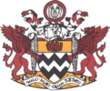
Municipality (1) — The town council adopted the Van Reede van Oudtshoorn arms "with certain modifications" on 7 February 1908.[10] The arms were : Argent, two bars dancetty Sable (i.e. a silver shield with two black zig-zag stripes across it), with two golden gryphons as supporters. A golden mural crown was placed above the shield (this appears to have been the "modification").

Municipality (2) — The arms were re-designed in 1959 by Ivan Mitford-Barberton and H. Ellis Tomlinson, and granted by the College of Arms on 9 September 1960. They were registered with the Cape Provincial Administration in June 1961[11] and at the Bureau of Heraldry in October 1970.[12]
The changes to the design were the addition of a red chief bearing a golden mural crown to the shield; the addition of a crest consisting of a pair of black wings inside a golden ring; and each supporter was given an ostrich feather to hold.[11][12] For some reason, the municipal council later changed the colours : the chief was changed to gold and the mural crown to red, the wings were changed to silver and the ring to red, and the gryphons were changed from gold to red. The registration at the Bureau does not appear to have been amended to reflect these alterations.
References[]
- ^ Jump up to: a b http://ewn.co.za/2016/08/16/Troubled-Oudtshoorn-Municipality-gets-new-mayor
- ^ Jump up to: a b c "Statistics by place". Statistics South Africa. Retrieved 27 September 2015.
- ^ "Statistics by place". Statistics South Africa. Retrieved 27 September 2015.
- ^ "Oudtshoorn Local Municipality". Census 2011.
- ^ Sum of the Main Places Oudtshoorn, Bongolethu and Bridgeton from Census 2011.
- ^ "Results Summary – All Ballots: Oudtshoorn" (PDF). Independent Electoral Commission. Retrieved 23 August 2016.
- ^ "Seat Calculation Detail: Oudtshoorn" (PDF). Independent Electoral Commission. Retrieved 23 August 2016.
- ^ "Voter Turnout Report: Oudtshoorn" (PDF). Electoral Commission. Retrieved 5 June 2017.
- ^ "Political composition of councils February 2017" (PDF). Western Cape Department of Local Government. February 2017. Retrieved 5 June 2017.
- ^ Western Cape Archives : Oudtshoorn Municipal Minutes (7 February 1908).
- ^ Jump up to: a b Cape of Good Hope Official Gazette 3087 (23 June 1961)
- ^ Jump up to: a b National Archives of South Africa : Data of the Bureau of Heraldry
External links[]
| show Municipalities and communities of Garden Route District Municipality, Western Cape |
|---|

| show Municipalities of the Western Cape |
|---|

- Local municipalities of the Garden Route District Municipality