Bitou Local Municipality
Bitou
Plett | |
|---|---|
 Seal | |
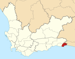 Location of Bitou Local Municipality within the Western Cape | |
| Coordinates: 33°55′S 23°25′E / 33.917°S 23.417°ECoordinates: 33°55′S 23°25′E / 33.917°S 23.417°E | |
| Country | South Africa |
| Province | Western Cape |
| District | Garden Route |
| Seat | Plettenberg Bay |
| Wards | 7 |
| Government | |
| • Type | Municipal council |
| • Mayor | Peter Lobese () |
| Area | |
| • Total | 992 km2 (383 sq mi) |
| Population (2011)[2] | |
| • Total | 49,162 |
| • Density | 50/km2 (130/sq mi) |
| Racial makeup (2011) | |
| • Black African | 45.2% |
| • Coloured | 31.2% |
| • Indian/Asian | 0.5% |
| • White | 16.9% |
| First languages (2011) | |
| • Afrikaans | 43.4% |
| • Xhosa | 38.0% |
| • English | 13.3% |
| • Other | 5.3% |
| Time zone | UTC+2 (SAST) |
| Municipal code | WC047 |

Bitou Local Municipality (Afrikaans: Bitou Munisipaliteit; Xhosa: uMasipala wase Bitou, formerly known as Plettenberg Bay Municipality) is a municipality part of Garden Route District Municipality located in the Western Cape Province of South Africa. Its municipality code is WC047.
Geography[]
The municipality covers an area of 992 square kilometres (383 sq mi) between the Indian Ocean and the Tsitsikamma Mountains around the town of Plettenberg Bay. It is the easternmost municipality on the coast of the Western Cape, with its eastern edge at the Bloukrans River forming the border with the Eastern Cape. It abuts on the Knysna Municipality to the west, the George Municipality to the northwest, and the Kou-Kamma Municipality to the east.
According to the 2011 census the municipality has a population of 49,162 people in 16,645 households. Of this population, 45.2% describe themselves as "Black African", 31.2% as "Coloured", and 16.9% as "White". The first language of 43.4% of the population is Afrikaans, while 38.0% speak Xhosa and 13.3% speak English.[4]
A majority of residents of the municipality live in the town of Plettenberg Bay, which in 2011 had a population of 31,804.[5] On the other side of the Keurbooms River mouth from Plettenberg Bay is the coastal resort of Keurboomstrand (pop. 475), while the resort of Nature's Valley (pop. 460) is situated further east at the mouth of the . The Griqua settlement of Kranshoek (pop. 5,597) is situated west of Plettenberg Bay. In the interior of the municipality are villages at Kurland (pop. 4,033) and Wittedrif (pop. 1,822).
History[]
At the end of the apartheid era, the area that is today the Bitou Municipality formed part of the South Cape Regional Services Council (RSC). The town of Plettenberg Bay was governed by a municipal council elected by the white residents while the coloured residents of New Horizons were governed by a management committee subordinate to the white council. The village of Kurland was also governed by a management committee, while the Griqua settlement at Kranshoek was governed by a board of management. The villages of Wittedrif, Keurboomstrand and Nature's Valley were governed by local councils.
After the national elections of 1994 a process of local government transformation began, in which negotiations were held between the existing local authorities, political parties, and local community organisations. As a result of these negotiations, the existing local authorities were dissolved and the Greater Plettenberg Bay Transitional Local Council (TLC) was established to replace all of them in December 1994.
The TLC was initially made up of members nominated by the various parties to the negotiations, until May 1996 when elections were held. At the time of these elections the South Cape District Council was established in place of the South Cape RSC, and transitional representative councils (TRCs) were elected to represent rural areas outside the TLCs on the District Council. The area that was to become Bitou Municipality included a part of the Outeniqua TRC.
At the local elections of December 2000 the TLCs and TRCs were dissolved and the Plettenberg Bay Municipality was established as a single local authority. At the same election the South Cape District Council was dissolved and replaced by the Eden District Municipality. In 2003 the Plettenberg Bay Municipality was renamed the Bitou Municipality.
Politics[]
The municipal council consists of thirteen members elected by mixed-member proportional representation. Seven councillors are elected by first-past-the-post voting in seven wards, while the remaining six are chosen from party lists so that the total number of party representatives is proportional to the number of votes received. In the election of 18 May 2011 no party obtained a majority; the Democratic Alliance (DA) and the African National Congress (ANC) won six seats each, with the remaining seat going to the Congress of the People (COPE). The DA and COPE formed a coalition to govern the municipality.[6]
The DA won a ward from the ANC in a by-election held in 2014, and governed Bitou alone with an outright majority of seats on the council.[7]
A hung council was elected following the 2016 municipal elections, with the DA and ANC each winning six seats, and the final seat going to the (AUF). The AUF chose to join forces with the ANC. However, six months later, in April 2017, the AUF announced that the partnership had fallen apart because the ANC had frustrated attempts to establish clean administration, had failed to commit resources to address problems, had not implemented the coalition agreement, and had not signed the agreed-upon service delivery plan. The DA and AUF negotiated for a month, following which the DA gained control of the municipality.[8]
The following table shows the results of the 2016 election.[9][10][11]
| Party | Votes | Seats | ||||||
|---|---|---|---|---|---|---|---|---|
| Ward | List | Total | % | Ward | List | Total | ||
| Democratic Alliance | 9,141 | 9,141 | 18,282 | 48.6% | 4 | 2 | 6 | |
| ANC | 7,746 | 7,673 | 15,419 | 41.0% | 3 | 3 | 6 | |
| 1,026 | 989 | 2,015 | 5.4% | 0 | 1 | 1 | ||
| EFF | 353 | 338 | 691 | 1.8% | 0 | 0 | 0 | |
| ACDP | 205 | 210 | 415 | 1.1% | 0 | 0 | 0 | |
| African Independent Congress | 148 | 263 | 411 | 1.1% | 0 | 0 | 0 | |
| COPE | 93 | 87 | 180 | 0.5% | 0 | 0 | 0 | |
| 51 | 62 | 113 | 0.3% | 0 | 0 | 0 | ||
| UDM | 19 | 41 | 60 | 0.2% | 0 | 0 | 0 | |
| 16 | 11 | 27 | 0.1% | 0 | 0 | 0 | ||
| Independent Civic Organisation | 9 | 8 | 17 | 0.0% | 0 | 0 | 0 | |
| Total | 18,807 | 18,823 | 37,630 | 7 | 6 | 13 | ||
| Valid votes | 18,807 | 18,823 | 37,630 | 99.0% | ||||
| Spoilt votes | 181 | 195 | 376 | 1.0% | ||||
| Total votes cast | 18,988 | 19,018 | 38,006 | |||||
| Voter turnout | 19,039 | |||||||
| Registered voters | 27,867 | |||||||
| Turnout percentage | 68.3% | |||||||
The local council sends two representatives to the council of the Garden Route District Municipality. As of February 2017 this delegation consisted of one councillor from the Democratic Alliance and one from the African National Congress.[12]
References[]
- ^ "Contact list: Executive Mayors". Government Communication & Information System. Archived from the original on 14 July 2010. Retrieved 22 February 2012.
- ^ Jump up to: a b "Statistics by place". Statistics South Africa. Retrieved 27 September 2015.
- ^ "Statistics by place". Statistics South Africa. Retrieved 27 September 2015.
- ^ "Bitou Local Municipality". Census 2011.
- ^ Sum of the Main Places Bossiesgerf, New Horizons, Kwanokuthula and Plettenberg Bay from Census 2011.
- ^ "Political composition of councils" (PDF). Western Cape Department of Local Government. August 2012. Retrieved 17 August 2012.
- ^ "'Important' win for DA in Plett by-election". Independent Online. Retrieved 2017-05-13.
- ^ "ANC booted in Bitou municipality, DA takes over". The Citizen. 2017-05-13. Retrieved 2017-05-13.
- ^ "Results Summary – All Ballots: Bitou" (PDF). Electoral Commission. Retrieved 5 June 2017.
- ^ "Seat Calculation Detail: Bitou" (PDF). Electoral Commission. Retrieved 5 June 2017.
- ^ "Voter Turnout Report: Bitou" (PDF). Electoral Commission. Retrieved 5 June 2017.
- ^ "Political composition of councils February 2017" (PDF). Western Cape Department of Local Government. February 2017. Retrieved 5 June 2017.
External links[]
| show Municipalities and communities of Garden Route District Municipality, Western Cape |
|---|

| show Municipalities of the Western Cape |
|---|

- Local municipalities of the Garden Route District Municipality