Paris, Missouri
Paris, Missouri | |
|---|---|
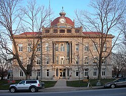 The Monroe County Courthouse in Paris. | |
 Location of Paris, Missouri | |
| Coordinates: 39°28′49″N 92°0′4″W / 39.48028°N 92.00111°WCoordinates: 39°28′49″N 92°0′4″W / 39.48028°N 92.00111°W | |
| Country | United States |
| State | Missouri |
| County | Monroe |
| Area | |
| • Total | 1.27 sq mi (3.29 km2) |
| • Land | 1.26 sq mi (3.27 km2) |
| • Water | 0.01 sq mi (0.02 km2) |
| Elevation | 692 ft (211 m) |
| Population | |
| • Total | 1,220 |
| • Estimate (2019)[3] | 1,167 |
| • Density | 924.72/sq mi (357.13/km2) |
| Time zone | UTC-6 (Central (CST)) |
| • Summer (DST) | UTC-5 (CDT) |
| ZIP code | 65275 |
| Area code(s) | 660 |
| FIPS code | 29-56144[4] |
| GNIS feature ID | 0724007[5] |
| Website | www |

Paris is a city in Monroe County, Missouri, United States. The population was 1,220 at the 2010 census. It is the county seat.[6]
History[]
Paris was platted in 1831, and named after Paris, Kentucky, the native home of a first settler.[7] A post office called Paris has been in operation since 1841.[8]
The Paris Male Academy and Union Covered Bridge are listed on the National Register of Historic Places.[9]
Geography[]
Paris is located at 39°28′49″N 92°0′4″W / 39.48028°N 92.00111°W (39.480162, -92.001245).[10] According to the United States Census Bureau, the city has a total area of 1.25 square miles (3.24 km2), of which 1.24 square miles (3.21 km2) is land and 0.01 square miles (0.03 km2) is water.[11]
Climate[]
The climate in this area is characterized by hot, humid summers and generally mild to cool winters. According to the Köppen Climate Classification system, Paris has a humid subtropical climate, abbreviated "Cfa" on climate maps.[12]
Demographics[]
| Historical population | |||
|---|---|---|---|
| Census | Pop. | %± | |
| 1870 | 895 | — | |
| 1880 | 1,253 | 40.0% | |
| 1890 | 1,487 | 18.7% | |
| 1900 | 1,397 | −6.1% | |
| 1910 | 1,474 | 5.5% | |
| 1920 | 1,431 | −2.9% | |
| 1930 | 1,367 | −4.5% | |
| 1940 | 1,473 | 7.8% | |
| 1950 | 1,407 | −4.5% | |
| 1960 | 1,393 | −1.0% | |
| 1970 | 1,442 | 3.5% | |
| 1980 | 1,598 | 10.8% | |
| 1990 | 1,486 | −7.0% | |
| 2000 | 1,529 | 2.9% | |
| 2010 | 1,220 | −20.2% | |
| 2019 (est.) | 1,167 | [3] | −4.3% |
| U.S. Decennial Census[13] | |||
2010 census[]
As of the census[2] of 2010, there were 1,220 people, 528 households, and 309 families living in the city. The population density was 983.9 inhabitants per square mile (379.9/km2). There were 643 housing units at an average density of 518.5 per square mile (200.2/km2). The racial makeup of the city was 93.7% White, 4.9% African American, 0.1% Native American, 0.2% Asian, 0.1% from other races, and 1.0% from two or more races. Hispanic or Latino of any race were 0.7% of the population.
There were 528 households, of which 24.8% had children under the age of 18 living with them, 43.2% were married couples living together, 10.4% had a female householder with no husband present, 4.9% had a male householder with no wife present, and 41.5% were non-families. 36.7% of all households were made up of individuals, and 21.8% had someone living alone who was 65 years of age or older. The average household size was 2.14 and the average family size was 2.77.
The median age in the city was 47.4 years. 19.8% of residents were under the age of 18; 6.9% were between the ages of 18 and 24; 21% were from 25 to 44; 24.5% were from 45 to 64; and 28% were 65 years of age or older. The gender makeup of the city was 43.8% male and 56.2% female.
2000 census[]
As of the census[4] of 2000, there were 1,529 people, 603 households, and 364 families living in the city. The population density was 1,228.5 people per square mile (476.1/km2). There were 682 housing units at an average density of 548.0 per square mile (212.4/km2). The racial makeup of the city was 92.15% White, 6.21% African American, 0.92% Native American, 0.07% Asian, and 0.65% from two or more races. Hispanic or Latino of any race were 0.46% of the population.
There were 603 households, out of which 27.0% had children under the age of 18 living with them, 48.4% were married couples living together, 9.1% had a female householder with no husband present, and 39.6% were non-families. 36.3% of all households were made up of individuals, and 22.6% had someone living alone who was 65 years of age or older. The average household size was 2.32 and the average family size was 3.03.
In the city, the population was spread out, with 22.8% under the age of 18, 7.3% from 18 to 24, 21.4% from 25 to 44, 20.0% from 45 to 64, and 28.5% who were 65 years of age or older. The median age was 44 years. For every 100 females there were 84.7 males. For every 100 females age 18 and over, there were 77.7 males.
The median income for a household in the city was $29,556, and the median income for a family was $36,917. Males had a median income of $27,813 versus $18,580 for females. The per capita income for the city was $14,980. About 5.8% of families and 10.4% of the population were below the poverty line, including 10.1% of those under age 18 and 10.8% of those age 65 or over.
Education[]
Public education in the city is administered by Paris R-II School District, which operates one elementary school, one middle school, and .[14]
Paris has a public library, a branch of the Little Dixie Regional Libraries.[15]
Notable people[]
- Mary Margaret McBride - Female radio pioneer, born near Paris.[16]
- Glenn Jacobs - WWE professional wrestler known as "Kane".
- Thomas Curtright - Professor of Physics at the University of Miami.
References[]
- ^ "2019 U.S. Gazetteer Files". United States Census Bureau. Retrieved July 26, 2020.
- ^ Jump up to: a b "U.S. Census website". United States Census Bureau. Retrieved 2012-07-08.
- ^ Jump up to: a b "Population and Housing Unit Estimates". United States Census Bureau. May 24, 2020. Retrieved May 27, 2020.
- ^ Jump up to: a b "U.S. Census website". United States Census Bureau. Retrieved 2008-01-31.
- ^ "US Board on Geographic Names". United States Geological Survey. 2007-10-25. Retrieved 2008-01-31.
- ^ "Find a County". National Association of Counties. Retrieved 2011-06-07.
- ^ "Monroe County Place Names, 1928–1945". The State Historical Society of Missouri. Archived from the original on June 24, 2016. Retrieved November 10, 2016.
- ^ "Post Offices". Jim Forte Postal History. Retrieved 10 November 2016.
- ^ "National Register Information System". National Register of Historic Places. National Park Service. July 9, 2010.
- ^ "US Gazetteer files: 2010, 2000, and 1990". United States Census Bureau. 2011-02-12. Retrieved 2011-04-23.
- ^ "US Gazetteer files 2010". United States Census Bureau. Archived from the original on 2012-07-02. Retrieved 2012-07-08.
- ^ Climate Summary for Paris, Missouri
- ^ "Census of Population and Housing". Census.gov. Retrieved June 4, 2015.
- ^ "Paris R-Ii School District". Great Schools. Retrieved 2 June 2019.
- ^ "Branch Information". Little Dixie Regional Libraries. Retrieved 2 June 2019.
- ^ HOW DEAR TO MY HEART by Mary Margaret McBride. The Macmillan Company 1940. Pgs. 119-120
External links[]
- City website
- Historic maps of Paris in the Sanborn Maps of Missouri Collection at the University of Missouri
| show Municipalities and communities of Monroe County, Missouri, United States |
|---|

| show Authority control |
|---|
- Populated places established in 1831
- Cities in Monroe County, Missouri
- County seats in Missouri
- Cities in Missouri
- 1831 establishments in Missouri