Parramatta Light Rail
| Parramatta Light Rail | |||
|---|---|---|---|
 | |||
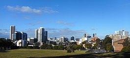 The routes serve Parramatta, the largest centre in Western Sydney | |||
| Overview | |||
| Status | Under construction | ||
| Owner | Transport for NSW | ||
| Termini | Westmead railway station Carlingford (stage 1) Sydney Olympic Park (stage 2) | ||
| Stations | 16 (stage 1) | ||
| Website | www.parramattalightrail.nsw.gov.au | ||
| Service | |||
| Services | 2 | ||
| Operator(s) | Transdev Australasia | ||
| Depot(s) | Camellia | ||
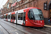
| Rolling stock | 13 Urbos 3s & 2 Citadis 305 (for testing) | ||
| History | |||
| Planned opening | 2023 (stage 1) | ||
| Technical | |||
| Line length |
| ||
| Track gauge | 1,435 mm (4 ft 8+1⁄2 in) | ||
| |||

The Parramatta Light Rail (often unofficially referred to as the Western Sydney Light Rail) is a project for a twelve-kilometre (seven-mile) light rail line in Sydney, New South Wales, Australia, which is currently under construction. The line will run from Westmead to Carlingford via the Western Sydney centre of Parramatta. The initial announcement of the project also included an eastern branch from Camellia to Strathfield. Plans to construct this branch were deferred in February 2017, and in October the original plans were replaced with a redesigned and truncated route to Sydney Olympic Park. The project will add to light rail in Sydney but the new line will be completely separated from the existing lines. It is being managed by Transport for NSW.[1]
Design[]
The routes will begin at Westmead before proceeding east to Camellia or Rydalmere via North Parramatta and the Parramatta CBD. At Camellia/Rydalmere the two routes split. The stage 1 route goes north to Carlingford, while the stage 2 route continues east to Sydney Olympic Park.
Stage 1 (main route through Parramatta and branch to Carlingford)[]
The stage 1 route was announced on 17 February 2017. The stage 1 route runs between Westmead and Carlingford via North Parramatta, the Parramatta CBD, Camellia, Rydalmere, Dundas and Telopea. It includes sixteen stops along a 12 km (7 mi) route. It includes two wire-free sections—one between Westmead and Cumberland Hospital—and another between Prince Alfred Square and Tramway Avenue.[2] The maintenance and stabling facility will be located east of Rosehill Racecourse. Trams will access the facility via a short branch line that uses the alignment of the Sandown railway line.[3][4]
The Environmental Impact Statement for stage 1 was released in August 2017.[5] Planning approval was granted in May 2018.[6]
The stage 1 stop names are open for public comment until 18 January 2021.[7] The stops and names are:[8][9]
| Name | Suburb | Platform arrangement |
Notes |
|---|---|---|---|
| Westmead | Westmead | 1 Island, 1 side | Includes 3 platforms, terminus of Western Sydney Stadium special event services. |
| Westmead Hospital | Westmead | Side | |
| Gurung | Westmead | Island | Darug word for infant, located near Westmead Children's Hospital. |
| Ngara | North Parramatta | Side | Darug word meaning 'to listen, hear, think', located near Cumberland Hospital. |
| Benaud | North Parramatta | Side | Named for nearby Richie Benaud Oval, located at Factory Street. |
| Fennell Street | Parramatta | Side | |
| Prince Alfred Square | Parramatta | Side | Serves Western Sydney Stadium. |
| Church Street Mall | Parramatta | Side | Known during development as Eat Street. |
| Parramatta Square | Parramatta | Side | Serves Parramatta railway station, terminus of Western Sydney Stadium and Rosehill Racecourse special event services. |
| Robin Thomas | Parramatta | Side | Named for nearby Robin Thomas Reserve, located at Harris Street. |
| Tramway Avenue | Parramatta | Side | Design changed from an island platform to side platforms in February 2018.[10] |
| Rosehill Gardens | Camellia | Side | Located at the site of the former Camellia railway station. Serves Rosehill Racecourse, terminus of special event services to the racecourse. |
| Yallamundi | Rydalmere | Side | Darug word relating to storytelling, located at the site of the former Rydalmere railway station. Serves Western Sydney University (Parramatta South) Campus. |
| Dundas | Dundas | Side | |
| Telopea | Telopea | Side | |
| Carlingford | Carlingford | Side |

Stage 2 (branch to Sydney Olympic Park)[]

The second branch of the light rail continues east to Sydney Olympic Park.
There are two options being considered for the connection to the stage 1 route. The first option would utilise the Carlingford railway line (and stage 1) corridor over the Parramatta River to Rydalmere, where it would then branch. The second option would leave the main stage 1 route at Camellia and utilise the branch line built to provide access to the tram depot. It would continue via the Sandown railway line corridor and Grand Avenue, then cross the Parramatta River just east of Rydalmere ferry wharf. Both versions of the route then continue via Ermington and Melrose Park, cross back to the south of the Parramatta River, pass through Wentworth Point and terminate at Sydney Olympic Park. The stage 2 route is around nine kilometres (six miles) long and will include ten to twelve stops.[11][12]
The original plans for this branch followed a route similar to that taken by Grand Avenue through Camellia before crossing the Duck River, passing through Newington, crossing Haslams Creek, serving Sydney Olympic Park and terminating at the major transport hub of Strathfield.[13]
Construction[]


In November 2017, a CPB Contractors/Downer Group joint venture and John Holland were shortlisted to build stage 1. At the same time, three consortia were shortlisted to supply the rolling stock, maintain the infrastructure and operate the services:[14][15]
- Connecting Parramatta: John Holland, Alstom and Deutsche Bahn
- Greater Parramatta: Downer Rail, Keolis Downer, Downer Group, Ansaldo and CRRC Changchun Railway Vehicles
- Great River City Light Rail: Transdev Australasia, CAF and Laing O'Rourke
The winning bidders were announced in December 2018. The CPB/Downer joint venture will build the majority of the infrastructure, while Great River City Light Rail will build the depot, light rail stops and power systems, supply the vehicles and operate the network. The total budget for stage 1 is A$2.4 billion.[2][16]
Construction began in 2018, with the line expected to open in 2023.[17]
In July 2018, work commenced on site remediation at the Camelia depot site.[18] Major construction was originally planned to start in June 2020.[19] This was brought forward to January 2020 and the first sod was turned on 31 January 2020.[20][21]
Micro tunnelling will be used to build drainage and stormwater capacity underneath Church Street, to minimise construction impacts and disruptions in comparison to traditional pipeline construction such as excavating above the ground.[22] The first micro-tunnel machine was launched in June 2020 from Centenary Square to Parramatta Town Hall and will connect to an existing pipe to extend stormwater capacity. A second micro-tunnel machine will also be launched from Centenary Square to Lennox Bridge to build drainage and stormwater capacity underneath Church Street.[23]
Major construction of Stage 1 commenced at Westmead in July 2020.[24]
Traffic changes[]
Traffic changes were implemented along and surrounding the light rail alignment as part of enabling works.[25]
Church Street[]
Church Street between Macquarie Street and Market Street became a pedestrian-only zone on 1 February 2020 prior to the start of major construction in June that year.[21][19] This included "Eat Street", a section of Church Street between George Street and Lennox Bridge where restaurants and outdoor tables and seating are located. The NSW government previously stated that work on 'Eat Street' would not start until 2020.[26][27][28] During construction, outdoor dining infrastructure along "Eat Street" would be removed and construction hoarding would be erected. The initial plan was, between 1 November to 31 January each year, 'Eat Street' would benefit from a construction 'grace period', when construction hoardings would be removed and outdoor tables and seating would be temporarily reintroduced.[29] This was to ensure that business owners, diners, tourists and shoppers do not experience constant construction works during the busy holiday season. However, after consulting with the Parramatta Light Rail Business Reference Group and Eat Street businesses, the plan was changed to 'fast tracking' the works during the initial grace period and delaying the grace period.[30] This would allow major construction to be completed earlier on August 2021, followed by a delayed grace period, before installation of stops, testing and commissioning begins.[31]
Church Street between Barney Street and Victoria Road was closed to traffic on 3 July 2020.[32] Bus services along Church Street were redirected to travel along O'Connell Street.
George Street[]
On 29 November 2019, George Street between O'Connell Street and Harris/Macarthur Street was converted from the existing one-way eastbound configuration into two-way traffic.[33] The parking and the travel lanes along the southern side of George Street were temporarily removed one week prior, to allow eastbound motorists to get used to travelling on the northern side of George Street. The conversion of George Street to two-way traffic is to offset the loss of westbound lanes on Macquarie Street, which is along the light rail alignment.[25]
O'Connell Street[]
In June 2020, works to widen O'Connell Street to four lanes between Barney Street and Albert Street were completed.[34] The intersection of O'Connell Street and Barney Street was also reconstructed to allow continuous flow between both roads.
Bus Service changes[]
After Church Street closed on 1 February 2020, the Parramatta free shuttle service 900 ran on a modified route, running along George Street instead of Macquarie Street.[35][21]
Railway line closures[]

The northern branch to Carlingford will reuse most of the Carlingford railway line, which closed on 5 January 2020.[36] The closure included Rosehill railway station, located between Clyde and Camellia, which will not be served by the light rail project.[13][37] The level crossing across Parramatta Road was also removed later that month.[38]
The Carlingford line was single track for most of its length, had shorter platforms than other lines in Sydney and had long been seen as under-utilised. Patronage declined from 446,000 journeys in 2001 to 260,000 journeys in 2014.[39] 2016-17 patronage figures based on Opal card tap on and off data recorded 511,000 journeys on the line during the year. This placed the line last among all train lines in the Opal network.[40] Various modification schemes to revitalise the line had been proposed. Action for Transport 2010, a New South Wales Government plan released in 1998, included the Parramatta Rail Link; a heavy rail line from Parramatta to Chatswood that would have utilised the Carlingford line between Camellia and Carlingford. As part of the CityRail Clearways Project announced in 2004, a passing loop was to have been built at Rydalmere, enabling a more frequent service.[41][42] Neither scheme came to fruition.
The Sandown railway line was officially closed in June 2019 and removal of the line and tracks began in July 2019.[43][44] This 1.5 kilometre line diverged from the Carlingford line at Camellia and ran close to the southern bank of the Parramatta River. Passenger services had ceased in December 1991, though the line's Rosehill platform remained in use for special charters, while freight trains ceased in June 2010 when trains from the Clyde Refinery last ran.[45][46][47] The western end of the Sandown line will be used by the light rail to provide access to a tram stabling and maintenance facility.[4]
Operation[]
Transdev will operate the network for eight years, with a possible extension of up to an additional ten years.[48]
A document produced by Transport for NSW in February 2017 stated services would operate every 7.5 minutes throughout the day.[17] However, a press release from December 2018 said services would operate every 7.5 minutes during peak periods, with frequencies at other times left unspecified.[2]
Fleet[]
Stage 1 will be operated by a fleet of thirteen Urbos 3 vehicles built by Construcciones y Auxiliar de Ferrocarriles (CAF).[48] Urbos 3 vehicles are also already in operation on the Dulwich Hill Line (Inner West Light Rail). However, unlike the Dulwich Hill Line, the Urbos 3 vehicles on the Parramatta Light Rail will operate in seven modules and are 45 metres (148 ft) long.[49][48] Some Citadis 305 trams will be tested on the Carlingford to Camellia branch to see if tram-train style vehicles will be more efficient.[citation needed]
History[]
Parramatta - Duck River tramway[]
Between 1883 and 1943, a tramway, operated by Sydney Ferries Limited, travelled from the Parramatta Park end of George Street to the mouth of the Duck River, where it originally connected with the company's Parramatta River ferry services to Sydney.[50][51][52] The connecting ferries ceased in 1928; the line then primarily carried freight until it closed in March 1943.[53][54][55] The Parramatta Light Rail will run via a similar route including via Tramway Avenue in Parramatta - named after the original line.
Route investigation[]
In 2013, Parramatta City Council published a $1 million feasibility study into a proposed Western Sydney Light Rail Network, designed to improve transport links throughout Western Sydney and meet the challenges posed by the projected rise in population in the region in the coming decades. The study found that a light rail system was a viable solution to address the growing transport needs of Parramatta and Western Sydney. The report estimated $20 million in funding was required to undertake a detailed investigation and to prepare a business case.[56] It proposed that construction of the network would take place in several stages, the first of which comprised a route from Macquarie Centre to Castle Hill via Eastwood, Dundas, Parramatta and Baulkham Hills, with a branch from Parramatta to Westmead. Further extensions were proposed from Parramatta to Bankstown and Rhodes.[56]
As part of its 2014/15 budget, the New South Wales Government announced Transport for NSW would investigate ten potential light rail routes in Western Sydney. The government allocated $400 million to ensure funds for detailed planning and construction of an initial project would be 'ready to go', should the investigations prove favourable.[57] Six of the ten routes being investigated were eliminated from contention in October 2014.[58] The routes investigated were:
| Route | Status | Notes |
|---|---|---|
| Parramatta to Bankstown | Not selected | |
| Parramatta to Castle Hill via Old Northern Road | Not selected | |
| Parramatta to Castle Hill via Windsor Road | Eliminated in October 2014 | Based on the route proposed by Parramatta City Council |
| Parramatta to Liverpool via the T-way | Eliminated in October 2014 | |
| Parramatta to Macquarie Park via Carlingford | Parramatta - Carlingford section selected | |
| Parramatta to Macquarie Park via Eastwood | Eliminated in October 2014 | Based on the route proposed by Parramatta City Council |
| Parramatta to Strathfield/Burwood via Sydney Olympic Park | Strathfield option selected | Route extended from Sydney Olympic Park to Strathfield/Burwood in October 2014 |
| Parramatta to Sydney CBD via Parramatta Road | Eliminated in October 2014 | |
| Parramatta to Rouse Hill | Eliminated in October 2014 | |
| Parramatta to Ryde via Victoria Road | Eliminated in October 2014 |
Of the final four routes, the Macquarie Park via Carlingford and the Strathfield via Olympic Park options were perceived as the frontrunners to be selected.[59] The Macquarie Park route was supported by Parramatta, Ryde and The Hills councils.[60][61][62] The Strathfield route was supported by The WestLine Partnership, a lobby group consisting of businesses and organisations with a presence in the area.[63] Auburn and Canada Bay councils were later joined by Strathfield Council as members of the group.[64][65]
The Strathfield route passes through industrial areas of Sydney and the potential for these areas to generate funding and patronage was a key point of contention during the lobbying period. The WestLine Partnership suggested the Strathfield route could be partially financed via value capture. Property developers building urban renewal projects along the line would provide a financial contribution to the government.[66] The group also suggested building a branch from Newington to Rhodes and indicated its funding model could allow a route to Carlingford to be built as well.[67] Supporters of the Macquarie Park route argued the needs of that corridor were more pressing and the Strathfield route would be poorly utilised in its early years.[68][69]
Official announcement[]

The Parramatta Light Rail scheme was officially unveiled on 8 December 2015, when the government announced it had selected the Strathfield route plus a truncated version of the Macquarie Park route that ends at Carlingford.[70] The two routes were proposed to converge at Camellia and proceed through Parramatta to Westmead.
The government's announcement included a $1 billion contribution towards the project. The government will also adopt the value capture approach advocated by The WestLine Partnership, by instigating an infrastructure contribution on new residential developments along the route. The revenue raised by the levy will be used to help fund the light rail and other infrastructure for the area.[70] The government's investigations into the value capture process held up the announcement of the preferred route but would reportedly have allowed the two lines to be built together.[66] The state government will also explore funding contributions from the federal and local tiers of government.[70] The convenor of The partnership stated that the light rail project's funding model would be used as a test case for funding future infrastructure projects.[65]
Construction of the lines was expected to commence in late 2018 but there was no announcement of an expected completion date or a total budget for the project.[71][72] An early estimate from January 2016 put the total cost at $3.51 billion.[73]
Deferral and redesign of the eastern branch[]
In August 2016, Transport for NSW noted the project could be delivered in stages.[74] A new metro line between the Sydney central business district and Parramatta was announced in November 2016.[75] The metro would adopt a similar route to the Strathfield branch of the light rail; media reports indicated the metro project would most likely cause the deferral of construction of this branch.[76] This was confirmed in February 2017, when it was announced that the Westmead - Camellia section and the Carlingford branch would be built as stage 1 of the light rail project.
Despite the deferral of construction, planning work for the Strathfield via Sydney Olympic Park branch continued.[17] Media reports indicated the route could shift from running to the south of the Parramatta River to the north of the river and that the section from Sydney Olympic Park to Strathfield could be dropped.[77][78]
The preferred stage 2 route was announced in October 2017. The changes reported on by the media were confirmed. The redesigned route runs from either Rydalmere or Camellia to Sydney Olympic Park via Ermington, Melrose Park and Wentworth Point. No details about the project's cost or construction dates were announced. As at October 2019 the final business case for stage 2 is still being considered.[11][79]
In November 2020, it was reported that a block of land at Camellia, bought by the NSW government for $53.5 million for the stage 2 extension, was effectively worthless because of high levels of soil contamination.[80] The purchase was referred to the Independent Commission Against Corruption (ICAC) because an internal investigation by the NSW transport department found the purchase of the land, for three times what the Valuer-General estimated it was worth, broke basic rules, and the land was bought from a developer without a valuation. The developer had bought the six-hectare parcel of land only months before, for $38 million.[81]
References[]
- ^ Parramatta Light Rail Transport for NSW Reviewed 23 July 2019
- ^ Jump up to: a b c "Parramatta Light Rail contracts signed". www.transport.nsw.gov.au. Transport for NSW. 20 December 2018.
- ^ "Transport for NSW 2015-16 Annual Report Volume 1" (PDF). Transport for NSW. p. 30. Archived from the original (PDF) on 18 November 2016. Retrieved 18 November 2016.
- ^ Jump up to: a b "Preferred route - stage 1" (PDF). Transport for NSW. Archived (PDF) from the original on 28 February 2019. Retrieved 17 February 2017.
- ^ Gilbert, Ewan (23 August 2017). "Parramatta Light Rail: Consultation for stage one nears end as Government confirms acquisitions". ABC News. Australian Broadcasting Corporation.
- ^ "Parramatta Light Rail approved". www.transport.nsw.gov.au. Transport for NSW. 30 May 2018. Retrieved 30 May 2018.
- ^ "Geographical Names Act 1966 (372)" (PDF). Government Gazette of the State of New South Wales. 11 December 2020. p. 2.
- ^ "Parramatta light rail to connect communities". Transport for NSW. 17 February 2017. Retrieved 17 February 2017.
- ^ "Parramatta Light Rail | Stage 1 – Westmead to Carlingford via Camellia: Environmental Impact Statement" (PDF). Transport for NSW. pp. 5-31–5-52, 5-84–5-85. Retrieved 24 August 2017.
- ^ "Parramatta Light Rail (Stage 1) – Westmead to Carlingford via Parramatta CBD and Camellia Submissions Report (incorporating Preferred Infrastructure Report)" (PDF). Transport for NSW. February 2018. pp. 6-49–6-50. Retrieved 25 February 2018.
- ^ Jump up to: a b "Parramatta Light Rail to Sydney Olympic Park". Transport for NSW. Retrieved 18 October 2017.
- ^ Constance, Andrew. "We're planning light rail extension to Sydney Olympic Park to improve public transport for 1000's[sic] of event goers". Twitter. Retrieved 19 October 2017.
- ^ Jump up to: a b "Parramatta Light Rail - How the preferred network was chosen". Transport for NSW. Archived from the original on 10 December 2015. Retrieved 8 December 2015.
- ^ World's best to build and operate Parramatta Light Rail Transport for NSW 22 November 2017
- ^ Parramatta light rail shortlists announced Metro Report International 23 November 2017
- ^ Downer JV awarded Parramatta Light Rail contract Downer Rail 28 December 2018
- ^ Jump up to: a b c "Parramatta Light Rail – Stage 1: frequently asked questions" (PDF). Transport for NSW. Retrieved 17 February 2017.
- ^ Future Parramatta light rail stabling site to be decontaminated Rail Express 15 May 2018
- ^ Jump up to: a b "Parramatta CBD's construction schedule released". Parramatta Light Rail. 23 October 2019. Archived from the original on 26 October 2019. Retrieved 4 November 2019.
- ^ "Major construction to begin in January 2020". Parramatta Light Rail. 19 December 2019. Retrieved 3 February 2020.
- ^ Jump up to: a b c "First sod turned for Paramatta Light Rail". Transport for NSW. 31 January 2020. Retrieved 3 February 2020.
- ^ "Micro Tunnelling". Parramatta Light Rail. Retrieved 16 June 2020.
- ^ "Micro-tunnel machine launches to Parramatta Town Hall". Parramatta Light Rail. 15 June 2020. Retrieved 16 June 2020.
- ^ Light rail taking shape in Westmead Parramatta Light Rail 30 July 2020.
- ^ Jump up to: a b "Enabling Road Works". Parramatta Light Rail. Retrieved 6 November 2019.
- ^ "Parramatta Light Rail – Stage 1: Connecting great places" (PDF). Transport for NSW. March 2017. pp. 1, 4. Archived from the original (PDF) on 21 June 2017. Retrieved 7 June 2017.
- ^ "NSW 'guarantees' later start of Parramatta Light Rail" Rail Express
- ^ Construction certainty for Parramatta 'Eat Street' Transport for NSW
- ^ "Construction on 'Eat Street' in 2020" (PDF). Parramatta Light Rail. 23 October 2019. Archived (PDF) from the original on 4 November 2019. Retrieved 4 November 2019.
- ^ "Eat Street light rail works fast-tracked". Parramatta Light Rail. 14 October 2020. Retrieved 25 January 2021.
- ^ "Eat Street light rail works fast-tracked" (PDF). Minister for Transport and Roads. 15 October 2020. Retrieved 25 January 2021.
- ^ "Closure Church St North Parramatta - Driver Notice" (PDF). CDC NSW. Retrieved 20 July 2020.
- ^ "Pedestrians Urged To Look Both Ways As Parramatta's George Street Becomes Two-Way". NSW Government - Tomorrow's Sydney. Retrieved 6 November 2019.
- ^ "Major roads makeover in Parramatta". Parramatta Light Raildate=10 June 2020. Retrieved 15 June 2020.
- ^ "Upcoming changes in Parramatta CBD". 27 January 2020. Retrieved 3 February 2020.
- ^ T6 Carlingford Line closure for Parramatta Light Rail –Temporary Transport Plan Transport for NSW
- ^ "Parramatta Light Rail | Stage 1 – Westmead to Carlingford via Camellia: Environmental Impact Statement" (PDF). Transport for NSW. pp. 5–65, 5–66, 8–27. Retrieved 24 August 2017.
- ^ "Boom! Gates are gone on Parramatta Road". Parramatta Light Rail. 29 January 2020. Retrieved 3 February 2020.
- ^ "Journeys by line and year". Bureau of Transport Statistics. p. Journeys by line. Archived from the original on 11 October 2015. Retrieved 28 July 2016.
- ^ "Train Patronage - Monthly Figures". Transport for NSW. Retrieved 13 July 2017.
- ^ "Big mini-budget for Sydney's rail network" Railway Digest May 2004 page 8
- ^ "State Environmental Planning Policy No 63—Major Transport Projects (Amendment No 3) under the Environmental Planning and Assessment Act 1979" (PDF). NSW Parliamentary Counsel's Office. September 2005. p. 7. Retrieved 22 April 2017.
- ^ "Transport Administration (Authority To Close Railway Lines – Carlingford And Sandown Lines) Order 2019 (66)" (PDF). Government Gazette of the State of New South Wales. 28 June 2019. p. 2269. Retrieved 28 June 2019.
- ^ "News Update September 2019 Newsletter" (PDF). Parramatta Light Rail. September 2019. Archived (PDF) from the original on 4 November 2019. Retrieved 4 November 2019.
- ^ "Cityrail launches new timetable". Railway Digest (February 1992): 45. 1992.
- ^ Walters, Chris (March 2020). "The Last Train to Carlingford". Railway Digest.
- ^ Sandown: End of the Line Railway Digest September 2010 page 24
- ^ Jump up to: a b c "Transfer Australasia Consortium Secures Parramatta Light Rail". 20 December 2018. Retrieved 4 November 2019.
- ^ "Parramatta Light Rail Overview" (PDF). Parramatta Light Rail. Archived from the original (PDF) on 3 December 2019. Retrieved 4 November 2019.
- ^ "The Parramatta Tram". The Sydney Morning Herald. 2 October 1883. Retrieved 14 July 2016.
- ^ Dunn, John (2006). Comeng: A History of Commonwealth Engineering Volume 1, 1921-1955. Kenthurst: Rosenberg Publishing. p. 95. ISBN 1877058424.
- ^ Oakes, John (2009). Sydney's Forgotten Industrial Railways. Redfern: Australian Railway Historical Society. p. 29. ISBN 9780980510645.
- ^ "Parramatta Ferry to Terminate at Bridge: Company's Decision". The Sun. 7 February 1928. Retrieved 7 June 2017.
- ^ Hoskins, Ian (2015). "River Cycles - A History of the Parramatta River". Dictionary of Sydney. Retrieved 7 June 2017.
- ^ McCarthy, Ken (April 1973). "The Era of the Steam Tramway" (PDF). Trolley Wire. 14 No. 2 (145): 3.
- ^ Jump up to: a b "Western Sydney Light Rail Network". Parramatta City Council. Archived from the original on 7 June 2015. Retrieved 3 July 2013.
- ^ "Parramatta light rail: $400 million reserved to transform travel to Sydney's second CBD". Transport for NSW. 17 June 2014. Archived from the original on 21 June 2014. Retrieved 18 June 2014.
- ^ "Four Western Sydney corridors shortlisted for Parramatta Light Rail". Transport for NSW. 27 October 2014. Archived from the original on 27 October 2014.
- ^ Lehmann, John (8 June 2015). "Sydney Olympic Park light rail project promises long-overdue 'linking up' of infrastructure". The Daily Telegraph. Retrieved 7 December 2015.
- ^ "MEDIA RELEASE: Parramatta City Council's vision for Western Sydney Light Rail". Parramatta City Council. 11 June 2015. Retrieved 7 December 2015.
- ^ "Parramatta to Macquarie Park Light Rail". City of Ryde. 8 May 2015. Retrieved 7 December 2015.
- ^ "Hills Mayor calls on James Shaw to change track on Light Rail route". The Hills Shire Council. 13 March 2015. Retrieved 7 December 2015.
- ^ "About The WestLine Partnership" (PDF). Sydney Olympic Park Business Association. The WestLine Partnership. Retrieved 7 December 2015.
- ^ "Strathfield Council commits $20,000 to support the WestLine Partnership". Strathfield Council. 27 March 2015.
- ^ Jump up to: a b The WestLine Partnership. "Full Steam Ahead for Light Rail Along Olympic Corridor". Sydney Olympic Park Business Association. Retrieved 28 December 2015.
- ^ Jump up to: a b Clennell, Andrew (7 December 2015). "Western Sydney light rail project worth more than $2b to be announced". The Daily Telegraph. Retrieved 7 December 2015.
- ^ FitzGerald, Deborah (24 February 2015). "Corporate push to connect light rail from Parramatta to Olympic Park with $1.1 billion in private funding". Parramatta Advertiser.
- ^ "The time is NOW for Light Rail to Carlingford". The Hills Shire Council. 8 June 2015. Retrieved 7 December 2015.
- ^ Kembrey, Melanie; Saulwick, Jacob (7 December 2015). "Premier Mike Baird to announce light rail from Parramatta to Sydney Olympic Park". The Sydney Morning Herald. Retrieved 7 December 2015.
- ^ Jump up to: a b c "Making it happen in Western Sydney: Parramatta light rail network unveiled". Transport for NSW. 8 December 2015. Archived from the original on 8 December 2015.
- ^ "Parramatta Light Rail". Transport for NSW. Retrieved 8 December 2015.
- ^ O'Sullivan, Matt (8 December 2015). "Parramatta light rail line via Sydney Olympic Park gets green light". The Sydney Morning Herald.
- ^ Saulwick, Jacob (16 October 2016). "Parramatta light rail costs blow out to more than $3.5 billion". The Sydney Morning Herald.
- ^ "Parramatta Light Rail Project Overview" (PDF). Transport for NSW. August 2016. p. 2.
- ^ "Sydney Metro West: a new railway, more trains for Western Sydney". Transport for NSW. 14 November 2016.
- ^ O'Sullivan, Matt (2 October 2016). "Change of course looms for multibillion-dollar Parramatta light rail". The Sydney Morning Herald.
- ^ "New route being considered for the Parramatta Light Rail". Twitter. Seven News Sydney. Retrieved 29 August 2017.
- ^ "Change of route leaves Sydney suburb out of light rail plans". 9news.com.au. Nine Digital. 14 July 2017. Retrieved 16 July 2017.
- ^ Frequently Asked Questions Parramatta Light Rail Accessed 9 October 2019
- ^ Ferguson, Adele; O'Sullivan, Matt (17 November 2020). "Secret report values controversial Sydney land as 'worthless'". Sydney Morning Herald. Retrieved 14 December 2020.
- ^ Ferguson, Adele; O'Sullivan, Matt (14 December 2020). "Internal probe into toxic land scandal reveals agency flouted rules". Sydney Morning Herald. Retrieved 14 December 2020.
External links[]
- Light rail in Sydney
- Proposed railway lines in Australia
- Transdev
- Under construction tram and light rail transit systems
- 2023 in rail transport
- Transport infrastructure in Parramatta
- Camellia, New South Wales