Payson, Arizona
Payson, Arizona | |
|---|---|
Town | |
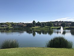 Green Valley Park | |
| Motto(s): "Arizona's Cool Mountain Town" | |
 Location of Payson in Gila County, Arizona | |
 Payson, Arizona Location in Arizona | |
| Coordinates: 34°14′22″N 111°19′39″W / 34.23944°N 111.32750°WCoordinates: 34°14′22″N 111°19′39″W / 34.23944°N 111.32750°W | |
| Country | |
| State | |
| County | Gila |
| Incorporated | 1973[1] |
| Government | |
| • Type | Council-manager |
| • Body | Payson Town Council |
| • Mayor | Tom Morrissey (Arizona politician) |
| Area | |
| • Total | 19.36 sq mi (50.13 km2) |
| • Land | 19.35 sq mi (50.11 km2) |
| • Water | 0.01 sq mi (0.02 km2) |
| Elevation | 5,000 ft (1,524 m) |
| Population | |
| • Total | 15,301 |
| • Estimate (2019)[4] | 15,813 |
| • Density | 817.29/sq mi (315.56/km2) |
| Time zone | UTC-7 (MST (no DST)) |
| ZIP codes | 85541, 85547 |
| Area code(s) | 928 |
| FIPS code | 04-53700 |
| GNIS ID(s) | 32746, 2413121 |
| Website | www |


Payson is a town in northern Gila County, Arizona, United States. Due to Payson's location being very near to the geographic center of Arizona, it has been called "The Heart of Arizona". The town is surrounded by the Tonto National Forest and has many outdoor activities year round. As of the 2010 census, the population of Payson was 15,301.[3]
History[]
Payson considers its founding year 1882, at which time the town was known as "Green Valley". On March 3, 1884, a post office was established with the help of Illinois Representative Levi Joseph Payson. In honor of the representative's help, the town's name was changed to "Payson".
Payson had its first rodeo in 1884. It considers its rodeo the "world's oldest continuous", as it has been held every year since.
In 1918 author Zane Grey made his first trip to the area surrounding Payson. He would come back with regularity through 1929, and would purchase two plots of land near Tonto Creek, including 120 acres (49 ha) from Sampson Elam Boles under Myrtle Point. Grey wrote numerous books about the area and also filmed some movies, such as To the Last Man, in the Payson area in the 1920s.
During Prohibition the manufacture, sale, and distribution of liquor was plentiful. The transactions took place on historic Bootleg Alley.[6]
During the 1930s an effort began to try to get Payson a better road to connect it to the outside world. At that time the town was very isolated, with a trip from Phoenix to Payson taking eight to twelve hours. Throughout the 1950s work on a paved road from Phoenix to Payson progressed, and the road was completed in 1958. A few years ago[when?] this highway, State Route 87 (also known as the "Beeline Highway"), was expanded to four lanes.
Geography[]
Located in northern Gila County at 34°14′22″N 111°19′39″W / 34.23944°N 111.32750°W (34.239462, -111.327456),[7] at an elevation of 5,000 feet (1,500 m), the town has a total area of 19.5 square miles (51 km2).[3] The Mogollon Rim, the southern boundary of the Colorado Plateau, lies to the north of Payson, with elevations exceeding 7,500 feet (2,300 m); there are many cold water lakes on top of the rim. They are stocked with fish by the Arizona Game and Fish Department.
Payson is bordered to the east by the town of Star Valley. Other nearby communities are Pine, Strawberry, Gisela and Rye, all within Gila County. Globe, the Gila County seat, is 80 miles (130 km) to the south via State Routes 87 and 188. State Route 87, the Beeline Highway, leads southwest 90 miles (140 km) to Phoenix and northeast 90 miles (140 km) to Winslow. State Route 260 leads east from Payson 90 miles (140 km) to Show Low.
Zane Grey Country[]

"Zane Grey Country" is a term for the area around Payson. This term was most often used in the 1970s and 1980s, and appeared in the header of the local newspaper, the Payson Roundup. In recent times it has fallen somewhat out of favor, as the term "Rim Country" has become more popular among locals.[citation needed]
Climate[]
Owing to its elevation of 5,000 feet (1,500 m), Payson has what is classified as a Mediterranean climate (Köppen Csa), though atypical for this climate with its early-summer drought and late-summer rainfall. While average temperatures do reach the high 80s to mid 90s in summer, the town's altitude usually keeps it protected from the 100 °F (37.8 °C)+ temperatures usually found at Arizona's lower elevations. Monsoon storms often develop in the later afternoon, bring heavy rainfall to the area and also lower the temperature. Summer nights cool down into the 50s.
Winter is also mild, with cold nights. January's average nighttime low is 25.3 °F or −3.7 °C with some nights in the teens, but by mid-afternoon, the temperature has usually risen into the 50s. There are only a few days of real winter, with 23.3 inches (0.59 m) of annual snowfall, but very little snow cover.
The weather in Payson is as varied as the landscape, and a snowstorm is often followed by weather so warm that any accumulation melts away within a day or two. In spring the desert blooms with a fiery array of Indian paintbrush, primrose, and the golds and fuchsias of cactus blossoms and other brightly colored wildflowers.
On Monday, November 5, 2001, between about 8 pm and 10:30 pm, Payson was treated to a rare display of the Northern Lights. It is extremely rare and only happens during solar flares because Payson is so far south. The lights appeared in a red color.[8]
| hideClimate data for Payson, Arizona | |||||||||||||
|---|---|---|---|---|---|---|---|---|---|---|---|---|---|
| Month | Jan | Feb | Mar | Apr | May | Jun | Jul | Aug | Sep | Oct | Nov | Dec | Year |
| Record high °F (°C) | 77 (25) |
80 (27) |
89 (32) |
91 (33) |
99 (37) |
106 (41) |
107 (42) |
104 (40) |
103 (39) |
94 (34) |
83 (28) |
76 (24) |
107 (42) |
| Average high °F (°C) | 54.4 (12.4) |
58.5 (14.7) |
63.0 (17.2) |
71.0 (21.7) |
79.7 (26.5) |
90.0 (32.2) |
92.9 (33.8) |
90.6 (32.6) |
85.4 (29.7) |
75.0 (23.9) |
62.5 (16.9) |
54.9 (12.7) |
73.2 (22.9) |
| Average low °F (°C) | 25.3 (−3.7) |
27.4 (−2.6) |
30.8 (−0.7) |
34.8 (1.6) |
41.6 (5.3) |
49.6 (9.8) |
57.9 (14.4) |
57.5 (14.2) |
50.5 (10.3) |
40.2 (4.6) |
30.1 (−1.1) |
25.2 (−3.8) |
39.2 (4.0) |
| Record low °F (°C) | −8 (−22) |
1 (−17) |
3 (−16) |
15 (−9) |
22 (−6) |
31 (−1) |
39 (4) |
37 (3) |
33 (1) |
16 (−9) |
6 (−14) |
−7 (−22) |
−8 (−22) |
| Average precipitation inches (mm) | 2.33 (59) |
2.34 (59) |
2.68 (68) |
1.15 (29) |
0.66 (17) |
0.37 (9.4) |
2.42 (61) |
2.97 (75) |
1.81 (46) |
1.89 (48) |
1.70 (43) |
1.75 (44) |
22.07 (558.4) |
| Average snowfall inches (cm) | 4.8 (12) |
5.0 (13) |
4.7 (12) |
2.9 (7.4) |
0 (0) |
0 (0) |
0 (0) |
0 (0) |
0 (0) |
0.1 (0.25) |
2.2 (5.6) |
3.6 (9.1) |
23.3 (59.35) |
| Average precipitation days (≥ 0.01 inch) | 6.4 | 5.9 | 7.0 | 3.9 | 3.1 | 2.2 | 9.6 | 10.6 | 6.5 | 4.7 | 4.5 | 5.1 | 69.5 |
| Average snowy days (≥ 0.1 inch) | 1.7 | 1.3 | 1.7 | 0.7 | 0 | 0 | 0 | 0 | 0 | 0.1 | 0.7 | 1.2 | 7.4 |
| Source: NOAA[9] | |||||||||||||
Demographics[]
| Historical population | |||
|---|---|---|---|
| Census | Pop. | %± | |
| 1970 | 1,787 | — | |
| 1980 | 5,068 | 183.6% | |
| 1990 | 8,377 | 65.3% | |
| 2000 | 13,620 | 62.6% | |
| 2010 | 15,301 | 12.3% | |
| 2019 (est.) | 15,813 | [4] | 3.3% |
| U.S. Decennial Census[10] | |||
As of the census[11] of 2019, there were 15,297 people living in Payson, AZ and is the 2,788th largest city in the United States. 5,832 households, and 4,070 families residing in the town. The population density was 791 people per square mile, which is 1275% higher than the Arizona average and 773% higher than the national average. There were 7,033 housing units at an average density of 361.2 per square mile (139.5/km2). The racial makeup of the town was 92.5% White, 0.2% Black or African American, 2.6% Native American, 0.5% Asian, <0.1% Pacific Islander, 3.0% from other races, and 1.3% from two or more races. 9.3% of the population were Hispanic or Latino of any race.
There were 5,832 households, out of which 21.7% had children under the age of 18 living with them, 58.6% were married couples living together, 8.0% had a female householder with no husband present, and 30.2% were non-families. 26.0% of all households were made up of individuals, and 14.6% had someone living alone who was 65 years of age or older. The average household size was 2.30 and the average family size was 2.71.
In the town, the population was spread out, with 18.1% under the age of 18, 4.6% from 18 to 24, 15.3% from 25 to 44, 25.9% from 45 to 64, and 36.2% who were 65 years of age or older. The median age was 57.1 years. This is approximately 54% higher than the Arizona average of 37. The male/female ratio was 0.9:1. English was spoken by 93% of people and Spanish was spoken by 5% of people.
The median income for a household in the town was $33,638, and the median income for a family was $38,713. Males had a median income of $30,900 versus $23,750 for females. The per capita income for the town was $19,513. About 6.5% of families and 9.9% of the population were below the poverty line, including 15.1% of those under age 18 and 4.7% of those age 65 or over.
Recreation[]


97% of the land around Payson is under the jurisdiction of the United States Forest Service (Payson is surrounded by the Tonto National Forest) or by tribal governments. Much of the land is available for recreational activities. Payson also has many hiking trails available to use. The Tonto Natural Bridge, the largest known natural bridge in the world, is located just northwest of Payson in Tonto Natural Bridge State Park, a unit of the Arizona State Park system. The area incorporates three golf courses, two of which belong to private country clubs. Mazatzal Casino, a tribal casino, is operated by the Tonto Apache Indian Reservation near the south end of the city.
The Payson area is a popular destination for rock hounds. In various areas surrounding the community quartz crystals can be found, some rivaling Herkimer diamonds in quality, as well as geodes, agate and onyx. Fossils are commonly found in the Paleozoic strata that is exposed along the Mogollon Rim to the north and west of Payson along State Route 87 and State Route 260.
Payson is known for its rodeo, the oldest continuous rodeo in the world.[12][13]
Payson has two parks, Green Valley Park and Rumsey Park. It also has two lakes, which are part of the Urban Fish Program. A community swimming pool is located near Rumsey Park, and the town hosts free outdoor concerts in the summer. Other activities include intramural sports like baseball and football. Payson also has a small skate park.
Payson hosts a Fourth of July fireworks display at Green Valley Park.
Culture[]

Payson is the site of the annual Arizona State Championship Old Time Fiddlers Contest, held in September. The fiddle contest features both local and nationally known players and awards cash prizes. Payson is also home of two rodeos. In May the Multi-Purpose Event Center across from the Tonto Apache Indian Reservation hosts the Gary Hardt Memorial Rodeo. In August, the historic August Doin's Rodeo (1884) takes place making Payson, Arizona the "Home of the World's Oldest Continuous Rodeo." Prescott is known as hosting the "World's Oldest Rodeo" (1888), but took a hiatus during World War II.
Public services[]
Education[]
The town is served by the Payson Unified School District.[14]
A branch of Gila Community College is located in Payson.[15]
Police department[]
In 2010, the Governor of Arizona appointed the Payson Police Department Executive Director, Detective Matt Van Camp, as state coordinator for the controversial Department of Defense reutilization program of military excess equipment, also known as the 1033 program.
Transportation[]
The Payson Senior Center operates the Beeline Bus, which provides local bus service to Payson, Star Valley, and Mesa del Caballo.[16] Mountain Valley Shuttle stops in Payson on its Phoenix–Show Low route.[17]
Historic structures[]
| Part of a series of the |
| Cities, towns and CDPs in Arizona with lists and images of historic properties, forts, cemeteries or historic districts |
|---|
The following are images of some of the historic structures recognized as such by the local Payson government. These properties have plaques which tell of their historical significance.
- The Haught Cabin – Henry and Sarah Haught built their log cabin in 1904 of alternating layers of logs and chinking in Roberts Mesa. The Haught's cabin measured 10′ by 18′. It had a dirt floor and no windows. The cabin was moved to Tonto Creek and by 1930, it was abandoned. In 1999, the cabin was moved once more, this time to the Green Valley Park and reassembled on the museum's grounds which is located at 700 South Green Valley Parkway.[18]
- The Sidles Mud House – Henry Sidles built in 1882, a poured mud house at 505A W. Main Street. The mud house was later purchased by August and Wilhelmina Pieper.[19]
- The Pieper Mansion – August and Wilhelmina Pieper built a new house which became known as the "Pieper Mansion" in 1893. After the house, which is located at 505 W. Main Street, was completed, the Piepers moved in and used the "mud house" for storage.[19]
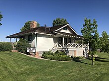
- The Ranger Station – This is the oldest Ranger Station still standing in the Southwest. It belonged to the Payson Ranger District of the National Tonto Forest. The station was built in 1907.[20]
- The Ranger Family House – was built in 1933 and as the Ranger Station it is the oldest Ranger Family House still standing in the Southwest.[20]
- The Ranger Office – was built in 1932 and together with the Ranger Station and the Ranger Family House completes the ranger complex of the Payson Ranger District. The three properties are located in the grounds of what is now the Green Valley Park on 700 South Green Valley Parkway.[20]
- The Ox Bow Inn and Saloon – built in 1933 and located at 607 W Main Street. The log inn was built as the Payson Hotel and the restaurant was named the Busy Bee. In 1945 the business was taken over and expanded by Jimmy Cox, who renamed the hotel the Ox Bow Inn.[21] The property was listed in the National Register of Historic Places on October 1, 2004, ref.: #04001073.
- The Tonto Bridge – Tonto Natural Bridge has been in the making for thousands of years. It is believed to be the largest natural travertine bridge in the world. By "travertine", what is meant that white or light-colored calcareous rock was deposited from mineral springs.

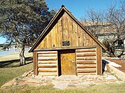
The Haught Cabin

The Haught Cabin viewed from a different angle
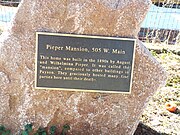
The Pieper Mansion historic marker

The Pieper Mansion
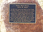
The Sidles Mud House historic marker
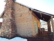
The Sidles Mud House

The Sidles Mud House viewed from a different angle
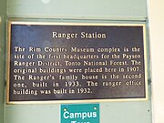
The Ranger Station historic marker

Ranger Station

Ranger Family House

Ranger Office

The Ox Bow Inn and Saloon

The Ox Bow Inn and Saloon viewed from a different angle
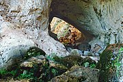
Tonto Natural Bridge


Nearest cities and towns[]
References[]
- ^ http://www.paysonaz.gov/Council/agendas/2015/03-05-15-A/I3cdrtowerwell.pdf
- ^ "Feature Detail Report for: Payson". Geographic Names Information System. United States Geological Survey.
- ^ Jump up to: a b c "Geographic Identifiers: 2010 Demographic Profile Data (G001): Payson town, Arizona". U.S. Census Bureau, American Factfinder. Retrieved October 28, 2016.[dead link]
- ^ Jump up to: a b "Population and Housing Unit Estimates". United States Census Bureau. May 24, 2020. Retrieved May 27, 2020.
- ^ "2019 U.S. Gazetteer Files". United States Census Bureau. Retrieved June 30, 2020.
- ^ Payson Roundup, December 4, 2002
- ^ "US Gazetteer files: 2010, 2000, and 1990". United States Census Bureau. 2011-02-12. Retrieved 2011-04-23.
- ^ http://www.schursastrophotography.com/latest22.html
- ^ "Payson, AZ" (PDF). National Oceanic and Atmospheric Administration. December 2011. Archived from the original (PDF) on July 22, 2014. Retrieved December 6, 2011.
- ^ "Census of Population and Housing". Census.gov. Retrieved June 4, 2016.
- ^ "U.S. Census website". United States Census Bureau. Retrieved 2008-01-31.
- ^ Pyle, Jinx; Jayne Peace Pyle (2004). Rodeo 101. Git a Rope! Publishing. ISBN 0-9722560-8-3.
- ^ Craven, Scott (August 18, 2006). "Ropin', rasslin' and bustin' bronc' World's Oldest Continuous Rodeo' in Payson". The Arizona Republic. Retrieved 2008-04-22.
- ^ Payson Unified School District
- ^ Gila Community College
- ^ "Routes-Map". Beeline Bus. Retrieved 2020-01-27.
- ^ "Route Schedule/Stops". Retrieved 2020-01-27.
- ^ Rim County Museum
- ^ Jump up to: a b The Mud House
- ^ Jump up to: a b c Smithsonian Magazine
- ^ "The History of Payson's Oxbow Inn & Saloon". Oxbow Inn. 2008-11-04.
External links[]
- Town of Payson official website
- Payson Roundup, local newspaper
- Payson visitors' site
- Tonto Natural Bridge State Park
- Tonto National Forest
| show Municipalities and communities of Gila County, Arizona, United States |
|---|

| show Authority control |
|---|
- Populated places of the Mogollon Rim
- Micropolitan areas of Arizona
- Towns in Gila County, Arizona
- Populated places established in 1882
- 1882 establishments in Arizona Territory