Polk City, Florida
Polk City, Florida | |
|---|---|
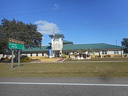 Polk City Government Center as seen from Florida State Road 559 | |
| Motto(s): " Building Today For A Better Today "
[1] | |
 Location in Polk County and the state of Florida | |
| Coordinates: 28°10′48″N 81°49′35″W / 28.18000°N 81.82639°WCoordinates: 28°10′48″N 81°49′35″W / 28.18000°N 81.82639°W | |
| Country | United States |
| State | Florida |
| County | Polk |
| Area | |
| • Total | 5.08 sq mi (13.17 km2) |
| • Land | 4.50 sq mi (11.67 km2) |
| • Water | 0.58 sq mi (1.50 km2) |
| Elevation | 171 ft (52 m) |
| Population (2010) | |
| • Total | 1,562 |
| • Estimate (2019)[5] | 2,724 |
| • Density | 604.66/sq mi (233.49/km2) |
| Time zone | UTC-5 (Eastern (EST)) |
| • Summer (DST) | UTC-4 (EDT) |
| ZIP code | 33868 |
| Area code(s) | 863 |
| FIPS code | 12-57950[4] |
| GNIS feature ID | 0289150[3] |
| Website | Polk City Florida Official Website |

Polk City is a city in Polk County, Florida, United States. The population was 1,562 at the 2010 census. As of 2018, the population recorded by the U.S. Census Bureau is 2,422.[6] It is part of the Lakeland–Winter Haven Metropolitan Statistical Area.
History[]
Polk City was incorporated as a Town in 1925, and changed by ordinance to the City of Polk City in 2005.[1] The city was named after the county, itself named after James Knox Polk, the eleventh president of the United States.[7]
Geography[]
According to the United States Census Bureau, the city has a total area of 0.8 square miles (2.1 km2), all land. Polk City is located within the Central Florida Highlands area of the Atlantic coastal plain with a terrain consisting of flatland interspersed with gently rolling hills.[8]
Climate[]
Polk City is located in the humid subtropical zone (Köppen climate classification: Cfa).[9]
Demographics[]
| Historical population | |||
|---|---|---|---|
| Census | Pop. | %± | |
| 1930 | 222 | — | |
| 1940 | 195 | −12.2% | |
| 1950 | 171 | −12.3% | |
| 1960 | 203 | 18.7% | |
| 1970 | 151 | −25.6% | |
| 1980 | 576 | 281.5% | |
| 1990 | 1,439 | 149.8% | |
| 2000 | 1,516 | 5.4% | |
| 2010 | 1,562 | 3.0% | |
| 2019 (est.) | 2,724 | [5] | 74.4% |
| U.S. Decennial Census[10] | |||
As of the census[4] of 2000, there were 1,516 people, 542 households, and 422 families residing in the town. The population density was 1,966.2 inhabitants per square mile (760.2/km2). There were 596 housing units at an average density of 773.0 per square mile (298.9/km2). The racial makeup of the town was 94.13% White, 1.91% African American, 0.33% Native American, 0.40% Asian, 1.78% from other races, and 1.45% from two or more races. Hispanic or Latino of any race were 8.11% of the population.
There were 542 households, out of which 39.1% had children under the age of 18 living with them, 55.4% were married couples living together, 14.9% had a female householder with no husband present, and 22.0% were non-families. 17.2% of all households were made up of individuals, and 5.2% had someone living alone who was 65 years of age or older. The average household size was 2.80 and the average family size was 3.07.[11] In the town the population was spread out, with 29.8% under the age of 18, 7.4% from 18 to 24, 32.4% from 25 to 44, 19.9% from 45 to 64, and 10.6% who were 65 years of age or older. The median age was 34 years. For every 100 females, there were 97.4 males. For every 100 females age 18 and over, there were 95.6 males.[citation needed]
The median income for a household in the town was $32,083, and the median income for a family was $36,705. Males had a median income of $28,158 versus $20,579 for females. The per capita income for the town was $14,108. About 13.6% of families and 13.4% of the population were below the poverty line, including 11.2% of those under age 18 and 5.7% of those age 65 or over.[citation needed]
Arts and culture[]
Annual cultural events[]
There is a yearly Founder's Day festival in midtown park located at the beginning of General James A. Van Fleet State Trail.[12]
Museums and other points of interest[]
Fantasy of Flight, an aviation-related attraction, takes visitors back to the pioneering days of early flight, World War I, World War II and beyond.[13] The museum closed in April 2014 but is planned to reopen later in a downscaled form.[14][15] Polk City Community Library is a public library that is a member of the Polk County Library Cooperative. It provides free computer use and interlibrary loan services. The library is located at 215 S. Bougainvillea Avenue.
Sports[]
While small in both size and population Polk City offers its residents a vast array of activities throughout the year. For children there is Tee-Ball and Little League as well as a Pee-Wee football league.
Government[]
Polk City is governed by a five-person council that elects a mayor and vice mayor from its membership.[16]
Utilities[]
The Polk City power grid is supported by distribution lines from Lakeland Electric and TECO.[17]
Infrastructure[]
Transportation[]
- Interstate 4 - Located just south of town, this freeway is a major highway in central Florida, leading westward to Lakeland and Tampa and eastward to Orlando.
- SR 33 - Called Commonwealth Avenue, this road leads southward to Lakeland and northward across the Green Swamp, toward Groveland.
- SR 559 - This road leads southward to I-4 and Auburndale.
References[]
- ^ Jump up to: a b c "Polk City Florida Official Website". Polk City Florida Official Website. Retrieved September 22, 2012.
- ^ "2019 U.S. Gazetteer Files". United States Census Bureau. Retrieved July 2, 2020.
- ^ Jump up to: a b U.S. Geological Survey Geographic Names Information System: Polk City, Florida
- ^ Jump up to: a b "U.S. Census website". United States Census Bureau. Retrieved 2008-01-31.
- ^ Jump up to: a b "Population and Housing Unit Estimates". United States Census Bureau. May 24, 2020. Retrieved May 27, 2020.
- ^ "Population and Housing Unit Estimates". Retrieved January 12, 2020.
- ^ "Profile for Polk City, Florida, FL". ePodunk. Retrieved September 22, 2012.
- ^ "Florida's Geological History". University of Florida. Retrieved 2010-10-14.
- ^ "World Map of the Köppen-Geiger climate classification updated". University of Veterinary Medicine Vienna. 2008-11-06. Retrieved 2010-09-10.
- ^ "Census of Population and Housing". Census.gov. Retrieved June 4, 2015.
- ^ [United States Department of Housing and Urban Development. (2008). Indiana income limits [Data file]. Retrieved from http://www.huduser.org/Datasets/IL/IL08/in_fy2008.pdf "Polk County"] Check
|url=value (help) (PDF). Office of Economic and Demographic Research. Office of Economic and Demographic Research. Retrieved 27 June 2021. - ^ "Polk City Founders' Day Set For Saturday". Retrieved September 19, 2012.
- ^ "Fantasy of Flight". Fantasy of Flight. Retrieved September 19, 2012.
- ^ "Fantasy of Flight closing as daily attraction". tbo.com. Archived from the original on 2014-03-09. Retrieved 2013-03-04.
- ^ "General aviation in the marketplace". General Aviation News/. Retrieved 2013-03-14.
- ^ Official website for Polk City
- ^ "LE and TECO Improve Reliability". Lakeland Electric. 2019-08-13. Retrieved 2020-03-10.
External links[]
 Media from Wikimedia Commons
 Travel guides from Wikivoyage
- Polk City Florida Official Website Portal style website, Government, Business, Library, Recreation and more
- Map of Polk City in 1927
- City-Data.com Comprehensive Statistical Data and more about Polk City
| show Municipalities and communities of Polk County, Florida, United States |
|---|

| show Authority control |
|---|
- Cities in Polk County, Florida
- Populated places established in 1925
- Cities in Florida