Poplar River (Montana–Saskatchewan)
| Poplar River | |
|---|---|
 | |
 The Poplar River | |
| Location | |
| Countries |
|
| Province | Saskatchewan |
| State | Montana |
| Counties | |
| Physical characteristics | |
| Source | |
| • coordinates | 49°15′13″N 106°23′32″W / 49.25361°N 106.39222°W[1] |
| Mouth | |
• coordinates | 48°05′03″N 105°11′08″W / 48.08417°N 105.18556°WCoordinates: 48°05′03″N 105°11′08″W / 48.08417°N 105.18556°W[1] |
• elevation | 1,942 feet (592 m)[1] |
| Discharge | |
| • location | near Poplar |
| • average | 122 cu ft/s (3.5 m3/s)[2] |
| Basin features | |
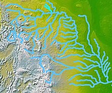
| River system | Missouri River |

The Poplar River is a tributary of the Missouri River, approximately 167 miles (269 km) long in Saskatchewan in Canada and Montana in the United States.
It rises in several forks on the plains of southern Saskatchewan. The western fork rises near Killdeer, Saskatchewan and flows southeast, into northeastern Montana, past Richland and across Daniels County. The middle fork rises northwest of Rockglen, Saskatchewan and flows southeast, into northeastern Montana, and passes west of Scobey. The two forks unite in the northern Fort Peck Indian Reservation. The combined fork flows southeast, then south-southwest, and joins the Missouri River near Poplar.
Along with the Milk River and Big Muddy Creek, it is one of three waterways in Canada that drain into the Gulf of Mexico.
Variant names[]
The Poplar River has also been known as: Lost Child Creek and Middle Fork Poplar River.[1]
See also[]
- List of Saskatchewan rivers
- List of rivers of Montana
Notes[]
- Rivers of Montana
- Rivers of Saskatchewan
- Tributaries of the Missouri River
- International rivers of North America
- Bodies of water of Roosevelt County, Montana
- Bodies of water of Daniels County, Montana
- Montana river stubs
- Canada river stubs
- Saskatchewan geography stubs