Radoma
Radoma | |
|---|---|
Municipality | |
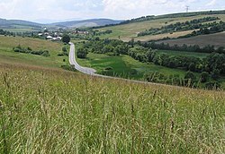 | |
 Radoma Location of Radoma in the Prešov Region | |
| Coordinates: 49°12′N 21°34′E / 49.200°N 21.567°ECoordinates: 49°12′N 21°34′E / 49.200°N 21.567°E | |
| Country | |
| Region | Prešov |
| District | Svidník |
| First mentioned | 1274 |
| Area | |
| • Total | 10.914 km2 (4.214 sq mi) |
| Elevation | 220 m (720 ft) |
| Population (2004-12-31) | |
| • Total | 439 |
| • Density | 40/km2 (100/sq mi) |
| Time zone | UTC+1 (CET) |
| • Summer (DST) | UTC+2 (CEST) |
| Postal code | 090 42 (pošta Okrúhle) |
| Area code(s) | +421-54 |
| Car plate | SK |
| Website | www |


Radoma is a village and municipality in Svidník District in the Prešov Region of north-eastern Slovakia.
History[]
In historical records the village was first mentioned in 1272.
Geography[]
The municipality lies at an altitude of 243 metres and covers an area of 10.914 km². It has a population of about 436 people.
External links[]
 Media related to Radoma at Wikimedia Commons
- Official website

This Prešov Region geography article is a stub. You can help Wikipedia by . |
Categories:
- Villages and municipalities in Svidník District
- Šariš
- Prešov Region geography stubs