Riley, Kansas
Riley, Kansas | |
|---|---|
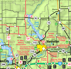
 Location within Riley County and Kansas | |
 | |
| Coordinates: 39°17′53″N 96°49′38″W / 39.29806°N 96.82722°WCoordinates: 39°17′53″N 96°49′38″W / 39.29806°N 96.82722°W | |
| Country | United States |
| State | Kansas |
| County | Riley |
| Founded | 1871 |
| Incorporated | 1903 |
| Area | |
| • Total | 0.48 sq mi (1.26 km2) |
| • Land | 0.48 sq mi (1.26 km2) |
| • Water | 0.00 sq mi (0.00 km2) |
| Elevation | 1,289 ft (393 m) |
| Population | |
| • Total | 939 |
| • Estimate (2019)[3] | 952 |
| • Density | 1,962.89/sq mi (757.79/km2) |
| Time zone | UTC-6 (CST) |
| • Summer (DST) | UTC-5 (CDT) |
| ZIP code | 66531 |
| Area code | 785 |
| FIPS code | 20-59875 [4] |
| GNIS ID | 476207 [5] |
| Website | cityofriley.org |

Riley is a city in Riley County, Kansas, United States. As of the 2010 census, the city population was 939.[6]
History[]
Riley was originally called Union, and under the latter name was founded in 1871. It was renamed Riley Center in the late 1870s.[7] Riley was the name of a railroad employee.[8]
Geography[]
Riley is located at 39°17′53″N 96°49′38″W / 39.29806°N 96.82722°W (39.298179, -96.827097).[9] According to the United States Census Bureau, the city has a total area of 0.48 square miles (1.24 km2), all of it land.[10]
Climate[]
The climate in this area is characterized by hot, humid summers and generally mild to cool winters. According to the Köppen Climate Classification system, Riley has a humid subtropical climate, abbreviated "Cfa" on climate maps.[11]
Demographics[]
| Historical population | |||
|---|---|---|---|
| Census | Pop. | %± | |
| 1880 | 93 | — | |
| 1910 | 343 | — | |
| 1920 | 364 | 6.1% | |
| 1930 | 431 | 18.4% | |
| 1940 | 392 | −9.0% | |
| 1950 | 414 | 5.6% | |
| 1960 | 575 | 38.9% | |
| 1970 | 668 | 16.2% | |
| 1980 | 779 | 16.6% | |
| 1990 | 804 | 3.2% | |
| 2000 | 886 | 10.2% | |
| 2010 | 939 | 6.0% | |
| 2019 (est.) | 952 | [3] | 1.4% |
| U.S. Decennial Census[12] | |||
Riley is part of the Manhattan, Kansas Metropolitan Statistical Area.
2010 census[]
As of the 2010 census,[2] there were 939 people, 363 households, and 251 families living in the city. The population density was 1,956.3 inhabitants per square mile (755.3/km2). There were 406 housing units at an average density of 845.8 per square mile (326.6/km2). The racial makeup of the city was 96.6% White, 0.6% African American, 1.3% Native American, 0.5% from other races, and 1.0% from two or more races. Hispanic or Latino of any race were 2.3% of the population.
There were 363 households, of which 38.0% had children under the age of 18 living with them, 52.1% were married couples living together, 12.1% had a female householder with no husband present, 5.0% had a male householder with no wife present, and 30.9% were non-families. 25.9% of all households were made up of individuals, and 7.4% had someone living alone who was 65 years of age or older. The average household size was 2.59 and the average family size was 3.15.
The median age in the city was 34 years. 29.9% of residents were under the age of 18; 5.6% were between the ages of 18 and 24; 30.1% were from 25 to 44; 24.8% were from 45 to 64; and 9.6% were 65 years of age or older. The gender makeup of the city was 50.1% male and 49.9% female.
2000 census[]
As of the census[4] of 2000, there were 886 people, 337 households, and 241 families living in the city. The population density was 2,170.5 people per square mile (834.4/km2). There were 376 housing units at an average density of 921.1 per square mile (354.1/km2). The racial makeup of the city was 94.13% White, 0.79% African American, 2.37% Native American, 0.34% Asian, 1.24% from other races, and 1.13% from two or more races. Hispanic or Latino of any race were 1.69% of the population.
There were 337 households, out of which 40.9% had children under the age of 18 living with them, 59.3% were married couples living together, 10.4% had a female householder with no husband present, and 28.2% were non-families. 23.7% of all households were made up of individuals, and 11.6% had someone living alone who was 65 years of age or older. The average household size was 2.63 and the average family size was 3.16.
In the city, the population was spread out, with 31.3% under the age of 18, 8.4% from 18 to 24, 30.7% from 25 to 44, 18.6% from 45 to 64, and 11.1% who were 65 years of age or older. The median age was 33 years. For every 100 females, there were 95.2 males. For every 100 females age 18 and over, there were 91.5 males.
The median income for a household in the city was $32,794, and the median income for a family was $37,955. Males had a median income of $26,528 versus $19,318 for females. The per capita income for the city was $15,164. About 8.7% of families and 10.7% of the population were below the poverty line, including 17.0% of those under age 18 and 3.4% of those age 65 or over.
Education[]
The community is served by Riley County USD 378 public school district.
Notable people[]
- Jordy Nelson, former National Football League wide receiver for the Green Bay Packers and Oakland Raiders.
See also[]
References[]
- ^ "2019 U.S. Gazetteer Files". United States Census Bureau. Retrieved July 24, 2020.
- ^ Jump up to: a b "U.S. Census website". United States Census Bureau. Retrieved 2012-07-06.
- ^ Jump up to: a b "Population and Housing Unit Estimates". United States Census Bureau. May 24, 2020. Retrieved May 27, 2020.
- ^ Jump up to: a b "U.S. Census website". United States Census Bureau. Retrieved 2008-01-31.
- ^ "US Board on Geographic Names". United States Geological Survey. 2007-10-25. Retrieved 2008-01-31.
- ^ "2010 City Population and Housing Occupancy Status". U.S. Census Bureau. Archived from the original on July 21, 2011. Retrieved November 1, 2011.
- ^ Kansas State Historical Society (1916). Biennial Report of the Board of Directors of the Kansas State Historical Society. Kansas State Printing Plant. pp. 276.
- ^ Capace, Nancy (1 June 2000). Encyclopedia of Kansas. North American Book Dist LLC. p. 259. ISBN 978-0-403-09312-0.
- ^ "US Gazetteer files: 2010, 2000, and 1990". United States Census Bureau. 2011-02-12. Retrieved 2011-04-23.
- ^ "US Gazetteer files 2010". United States Census Bureau. Archived from the original on January 12, 2012. Retrieved 2012-07-06.
- ^ Climate Summary for Riley, Kansas
- ^ United States Census Bureau. "Census of Population and Housing". Retrieved August 21, 2014.
External links[]
| hide Municipalities and communities of Riley County, Kansas, United States | ||
|---|---|---|
| Cities |  | |
| Unincorporated communities | ||
| Footnotes | †This populated place is designated a Census-Designated Place (CDP) by the United States Census Bureau. ‡This populated place also has portions in an adjacent county or counties. | |
| ||
| Authority control |
|
|---|
- Cities in Kansas
- Cities in Riley County, Kansas
- Manhattan, Kansas metropolitan area