Ripley Township, Brown County, Illinois
Ripley Township | |
|---|---|
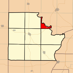 Location in Brown County | |
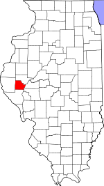 Brown County's location in Illinois | |
| Coordinates: 40°01′34″N 90°39′32″W / 40.02611°N 90.65889°WCoordinates: 40°01′34″N 90°39′32″W / 40.02611°N 90.65889°W | |
| Country | United States |
| State | Illinois |
| County | Brown |
| Established | November 8, 1853 |
| Area | |
| • Total | 6.04 sq mi (15.6 km2) |
| • Land | 6.04 sq mi (15.6 km2) |
| • Water | 0 sq mi (0 km2) 0% |
| Elevation | 581 ft (177 m) |
| Population (2010) | |
| • Estimate (2016)[1] | 100 |
| • Density | 16.9/sq mi (6.5/km2) |
| Time zone | UTC-6 (CST) |
| • Summer (DST) | UTC-5 (CDT) |
| ZIP code | 62353 |
| FIPS code | 17-009-64187 |

Ripley Township is one of nine townships in Brown County, Illinois, USA. As of the 2010 census, its population was 102 and it contained 59 housing units.[2]
Geography[]
According to the 2010 census, the township has a total area of 6.04 square miles (15.6 km2), all land.[2]
Cities[]
- Ripley (vast majority)
Cemeteries[]
The township contains Ripley Township Cemetery.
Major highways[]
 US Route 24
Demographics[]
| Historical population | |||
|---|---|---|---|
| Census | Pop. | %± | |
| 2016 (est.) | 100 | [1] | |
| U.S. Decennial Census[3] | |||
School districts[]
- Brown County Community Unit School District 1
Political districts[]
- Illinois' 18th congressional district
- State House District 93
- State Senate District 47
References[]
- "Ripley Township, Brown County, Illinois". Geographic Names Information System. United States Geological Survey. Retrieved 2010-01-04.
- United States Census Bureau 2007 TIGER/Line Shapefiles
- United States National Atlas
- ^ a b "Population and Housing Unit Estimates". Retrieved June 9, 2017.
- ^ a b "Population, Housing Units, Area, and Density: 2010 - County -- County Subdivision and Place -- 2010 Census Summary File 1". United States Census. Archived from the original on 2020-02-12. Retrieved 2013-05-28.
- ^ "Census of Population and Housing". Census.gov. Retrieved June 4, 2016.
External links[]
Places adjacent to Ripley Township, Brown County, Illinois | |
|---|---|
Municipalities and communities of Brown County, Illinois, United States | ||
|---|---|---|
| Cities | ||
| Villages | ||
| Townships | ||
| Unincorporated communities | ||
| Ghost towns | ||
| ||
Categories:
- Townships in Brown County, Illinois
- Populated places established in 1853
- Townships in Illinois
- 1853 establishments in Illinois