Roscoe, Nebraska
Roscoe, Nebraska | |
|---|---|
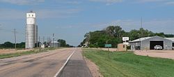 Roscoe, seen from the east along U.S. Highway 30 | |
 Roscoe | |
| Coordinates: 41°07′50″N 101°35′09″W / 41.13056°N 101.58583°WCoordinates: 41°07′50″N 101°35′09″W / 41.13056°N 101.58583°W | |
| Country | United States |
| State | Nebraska |
| County | Keith |
| Area | |
| • Total | 0.16 sq mi (0.41 km2) |
| • Land | 0.16 sq mi (0.41 km2) |
| • Water | 0.0 sq mi (0.0 km2) |
| Elevation | 3,173 ft (967 m) |
| Population (2010) | |
| • Total | 63 |
| • Density | 400/sq mi (154.6/km2) |
| Time zone | UTC-7 (Central (CST)) |
| • Summer (DST) | UTC-6 (CDT) |
| ZIP Code | 69153 |
| Area code(s) | 308 |
| FIPS code | 31-42285 |
| GNIS feature ID | 832680 |


Roscoe is an unincorporated community and census-designated place in Keith County, Nebraska, United States. As of the 2010 census it had a population of 63.[1]
Geography[]
Roscoe is in east-central Keith County in the valley of the South Platte River. Its altitude is 3,173 feet (967 m) above sea level.[2] U.S. Route 30 passes through the community, leading west 7 miles (11 km) to Ogallala, the Keith county seat, and east 12 miles (19 km) to Paxton. Nebraska Link 51B leads south 1 mile (1.6 km) across the South Platte River to Interstate 80 at Exit 133.
According to the U.S. Census Bureau, the Roscoe CDP has an area of 0.16 square miles (0.41 km2), all land.[1]
History[]
Roscoe got its start in the 1870s when the railroad was extended to that point.[3]
References[]
- ^ a b "Geographic Identifiers: 2010 Census Summary File 1 (G001), Roscoe CDP, Nebraska". American FactFinder. U.S. Census Bureau. Archived from the original on February 13, 2020. Retrieved April 11, 2019.
- ^ U.S. Geological Survey Geographic Names Information System: Roscoe, Nebraska
- ^ Burr, George L.; Buck, O. O. (1921). History of Hamilton and Clay Counties, Nebraska. S.J. Clarke Publishing Company. p. 123.
Municipalities and communities of Keith County, Nebraska, United States | ||
|---|---|---|
| City | ||
| Villages | ||
| CDPs | ||
| Unincorporated communities | ||
| ||
This Keith County, Nebraska state location article is a stub. You can help Wikipedia by . |
- Census-designated places in Keith County, Nebraska
- Census-designated places in Nebraska
- South Central Nebraska geography stubs