Ogallala, Nebraska
Ogallala, Nebraska | |
|---|---|
 Front Street tourist attraction | |
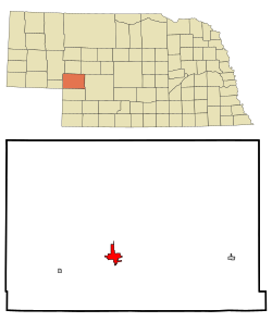 Location of Ogallala, Nebraska | |
| Coordinates: 41°7′44″N 101°43′10″W / 41.12889°N 101.71944°WCoordinates: 41°7′44″N 101°43′10″W / 41.12889°N 101.71944°W | |
| Country | United States |
| State | Nebraska |
| County | Keith |
| Founded | 1868 |
| Government | |
| • Type | City Council/City Manager |
| • Mayor | Deb Schilz |
| • City Manager | Bruce Smith |
| Area | |
| • Total | 5.02 sq mi (13.00 km2) |
| • Land | 4.96 sq mi (12.84 km2) |
| • Water | 0.06 sq mi (0.16 km2) |
| Elevation | 3,222 ft (982 m) |
| Population | |
| • Total | 4,737 |
| • Estimate (2019)[4] | 4,497 |
| • Density | 907.20/sq mi (350.28/km2) |
| Time zone | UTC-7 (Mountain (MST)) |
| • Summer (DST) | UTC-6 (MDT) |
| ZIP code | 69153 |
| Area code(s) | 308 |
| FIPS code | 31-35980 |
| GNIS feature ID | 0831832[3] |
| Website | ogallala-ne.gov |

Ogallala is a city in and the county seat of Keith County, Nebraska, United States.[5] The population was 4,737 at the 2010 census. In the days of the Nebraska Territory, the city was a stop on the Pony Express and later along the transcontinental railroad. The Ogallala Aquifer was named after the city.
History[]
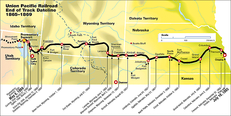
Ogallala first gained fame as a terminus for cattle drives that traveled from Texas to the Union Pacific railhead located there. These trails are known as the Western or Great Western trails.[6][7] The Union Pacific Railroad reached Ogallala on May 24, 1867.[8] The city itself was not laid out until 1875 and not incorporated until 1884[9] The town's name comes from the Oglala Sioux tribe.[10]
Geography[]
Ogallala is located at 41°7′44″N 101°43′10″W / 41.12889°N 101.71944°W (41.128806, -101.719460).[11] According to the United States Census Bureau, the city has a total area of 5.02 square miles (13.00 km2), of which 4.96 square miles (12.85 km2) is land and 0.06 square miles (0.16 km2) is water.[12] Ogallala is in the US Mountain Time Zone (UTC−7/-6). Ogallala is close to Lake McConaughy, a large man-made lake and a state recreation area with sandy beaches, boating and swimming. The South Platte River runs through Ogallala.
Climate[]
| Ogallala, Nebraska | ||||||||||||||||||||||||||||||||||||||||||||||||
|---|---|---|---|---|---|---|---|---|---|---|---|---|---|---|---|---|---|---|---|---|---|---|---|---|---|---|---|---|---|---|---|---|---|---|---|---|---|---|---|---|---|---|---|---|---|---|---|---|
| Climate chart (explanation) | ||||||||||||||||||||||||||||||||||||||||||||||||
| ||||||||||||||||||||||||||||||||||||||||||||||||
| ||||||||||||||||||||||||||||||||||||||||||||||||
Ogallala has a dry humid continental climate (Köppen Dfa), bordering on cold semi-arid with an annual average precipitation of 20.40 in (518 mm). Winters are cold, while summers are hot and often stormy. Precipitation is greatest in the late spring and summer, with winter being the driest part of the year.
| hideClimate data for Ogallala, Nebraska | |||||||||||||
|---|---|---|---|---|---|---|---|---|---|---|---|---|---|
| Month | Jan | Feb | Mar | Apr | May | Jun | Jul | Aug | Sep | Oct | Nov | Dec | Year |
| Record high °F (°C) | 74 (23) |
78 (26) |
92 (33) |
95 (35) |
100 (38) |
108 (42) |
115 (46) |
109 (43) |
109 (43) |
95 (35) |
82 (28) |
76 (24) |
115 (46) |
| Average high °F (°C) | 38.2 (3.4) |
43.2 (6.2) |
51.4 (10.8) |
62.7 (17.1) |
72.5 (22.5) |
83.1 (28.4) |
90.8 (32.7) |
88.5 (31.4) |
78.8 (26.0) |
67.1 (19.5) |
51.4 (10.8) |
40.9 (4.9) |
64.1 (17.8) |
| Average low °F (°C) | 11.9 (−11.2) |
16.2 (−8.8) |
23.7 (−4.6) |
34.2 (1.2) |
44.8 (7.1) |
54.9 (12.7) |
61.0 (16.1) |
58.7 (14.8) |
47.6 (8.7) |
35.0 (1.7) |
22.7 (−5.2) |
14.6 (−9.7) |
35.4 (1.9) |
| Record low °F (°C) | −29 (−34) |
−30 (−34) |
−23 (−31) |
−10 (−23) |
19 (−7) |
32 (0) |
38 (3) |
37 (3) |
15 (−9) |
−3 (−19) |
−10 (−23) |
−36 (−38) |
−36 (−38) |
| Average precipitation inches (mm) | 0.44 (11) |
0.43 (11) |
1.10 (28) |
2.17 (55) |
3.19 (81) |
2.98 (76) |
2.70 (69) |
2.22 (56) |
1.49 (38) |
1.01 (26) |
0.56 (14) |
0.46 (12) |
18.76 (477) |
| Average snowfall inches (cm) | 4.7 (12) |
4.8 (12) |
6.8 (17) |
3.7 (9.4) |
0.3 (0.76) |
0 (0) |
0 (0) |
0 (0) |
0.1 (0.25) |
1.6 (4.1) |
5.0 (13) |
4.3 (11) |
31.3 (80) |
| Source: [13] | |||||||||||||
Demographics[]
| Historical population | |||
|---|---|---|---|
| Census | Pop. | %± | |
| 1880 | 114 | — | |
| 1890 | 494 | 333.3% | |
| 1900 | 355 | −28.1% | |
| 1910 | 643 | 81.1% | |
| 1920 | 1,062 | 65.2% | |
| 1930 | 1,631 | 53.6% | |
| 1940 | 3,159 | 93.7% | |
| 1950 | 3,456 | 9.4% | |
| 1960 | 4,250 | 23.0% | |
| 1970 | 4,976 | 17.1% | |
| 1980 | 5,638 | 13.3% | |
| 1990 | 5,095 | −9.6% | |
| 2000 | 4,930 | −3.2% | |
| 2010 | 4,737 | −3.9% | |
| 2019 (est.) | 4,497 | [4] | −5.1% |
| U.S. Decennial Census[14] 2012 Estimate[15] | |||
2010 census[]
As of the census[2] of 2010, there were 4,737 people, 2,100 households, and 1,298 families living in the city. The population density was 955.0 inhabitants per square mile (368.7/km2). There were 2,397 housing units at an average density of 483.3 per square mile (186.6/km2). The racial makeup of the city was 94.6% White, 0.2% African American, 0.6% Native American, 0.4% Asian, 2.2% from other races, and 2.0% from two or more races. Hispanic or Latino of any race were 7.5% of the population.
There were 2,100 households, of which 27.5% had children under the age of 18 living with them, 48.0% were married couples living together, 9.6% had a female householder with no husband present, 4.2% had a male householder with no wife present, and 38.2% were non-families. 34.1% of all households were made up of individuals, and 14.6% had someone living alone who was 65 years of age or older. The average household size was 2.23 and the average family size was 2.85.
The median age in the city was 43.7 years. 23.6% of residents were under the age of 18; 6.8% were between the ages of 18 and 24; 21.4% were from 25 to 44; 28.3% were from 45 to 64; and 20.1% were 65 years of age or older. The gender makeup of the city was 48.8% male and 51.2% female.
2000 census[]
As of the census of 2000, there were 4,930 people, 2,052 households, and 1,339 families living in the city. The population density was 1,472.4 people per square mile (568.2/km2). There were 2,314 housing units at an average density of 691.1 per square mile (266.7/km2). The racial makeup of the city was 96.45% White, 0.02% African American, 0.87% Native American, 0.22% Asian, 1.68% from other races, and 0.75% from two or more races. Hispanic or Latino of any race were 4.79% of the population.
There were 2,052 households, out of which 31.5% had children under the age of 18 living with them, 53.0% were married couples living together, 9.5% had a female householder with no husband present, and 34.7% were non-families. 30.7% of all households were made up of individuals, and 14.7% had someone living alone who was 65 years of age or older. The average household size was 2.35 and the average family size was 2.94.
In the city, the population was spread out, with 26.5% under the age of 18, 6.7% from 18 to 24, 26.5% from 25 to 44, 21.9% from 45 to 64, and 18.4% who were 65 years of age or older. The median age was 39 years. For every 100 females, there were 89.0 males. For every 100 females age 18 and over, there were 85.0 males.
As of 2000 the median income for a household in the city was $32,141, and the median income for a family was $39,688. Males had a median income of $27,436 versus $18,292 for females. The per capita income for the city was $17,674. About 5.0% of families and 7.8% of the population were below the poverty line, including 9.3% of those under age 18 and 9.1% of those age 65 or over.
Education[]


Public schools[]
Ogallala is served by the Ogallala Public School District [16]
- High School—Ogallala High School
- Elementary and Middle School—Prairie View School (grade PK-8)
Private schools[]
- St. Paul's Lutheran School (PreK-5)
- St. Luke's Catholic School (PreK-5)
Media[]
Radio[]
Newspaper[]
- Keith County News (bi-weekly)
Point of interest[]
The Ogallala post office contains an oil-on-canvas mural, titled Long Horns, painted in 1938 by Frank Mechau. Murals were produced from 1934 to 1943 in the United States through the Section of Painting and Sculpture, later called the Section of Fine Arts, of the Treasury Department.[17]
Notable people[]
- John Lanigan – longtime morning radio host at WMJI in Cleveland; National Radio Hall of Fame inductee
- Ken Schilz – Nebraska state senator
- Thomas Shanahan – United States federal judge
References[]
- ^ "2019 U.S. Gazetteer Files". United States Census Bureau. Retrieved July 26, 2020.
- ^ Jump up to: a b "U.S. Census website". United States Census Bureau. Retrieved 2012-06-24.
- ^ "US Board on Geographic Names". United States Geological Survey. 2007-10-25. Retrieved 2008-01-31.
- ^ Jump up to: a b "Population and Housing Unit Estimates". United States Census Bureau. May 24, 2020. Retrieved May 27, 2020.
- ^ "Find a County". National Association of Counties. Archived from the original on May 31, 2011. Retrieved 2011-06-07.
- ^ Skaggs, Jimmy M. "WESTERN TRAIL". Handbook of Texas Online. exas State Historical Association. Retrieved 2010-07-20.
- ^ Busby, Myra. "Along The Great Western Cattle Trail". www.greatwesterncattletrail.com. Retrieved 2010-07-20.
- ^ "Union Pacific End of Track Dateline 1865-1869" (GIF). Historical Maps of the Union Pacific. Union Pacific Railroad Company. Retrieved 2010-07-20.
- ^ Seltzer, Leon, ed. (1952), "Ogallala, Nebraska", Columbia Lippincott Gazetteer of the world: Lippincott's pronouncing gazetteer, New York: Columbia University Press, p. 1378
- ^ "history of ogallala..." Official Website, City of Ogallala. City of Ogallala. Retrieved 19 August 2012.
- ^ "US Gazetteer files: 2010, 2000, and 1990". United States Census Bureau. 2011-02-12. Retrieved 2011-04-23.
- ^ "US Gazetteer files 2010". United States Census Bureau. Archived from the original on January 12, 2012. Retrieved 2012-06-24.
- ^ https://wrcc.dri.edu/cgi-bin/cliMAIN.pl?ne6200
- ^ United States Census Bureau. "Census of Population and Housing". Retrieved October 18, 2013.
- ^ "Annual Estimates of the Resident Population: April 1, 2010 to July 1, 2012". Archived from the original on June 2, 2013. Retrieved October 18, 2013.
- ^ "Ogallala Public School District". www.opsd.org. Retrieved 2010-07-20.
- ^ Park, Marlene and Gerald E. Markowitz, Democratic vistas: Post Offices and Public Art in the New Deal, Temple University Press, Philadelphia 1984
External links[]
| Wikimedia Commons has media related to Ogallala, Nebraska. |
- City of Ogallala
 Geographic data related to Ogallala, Nebraska at OpenStreetMap
| show Municipalities and communities of Keith County, Nebraska, United States |
|---|

- Cities in Nebraska
- Cities in Keith County, Nebraska
- County seats in Nebraska
- Populated places established in 1875
- Pony Express stations
- Boot Hill cemeteries