Colfax County, Nebraska
Colfax County | |
|---|---|
 Colfax County Courthouse in Schuyler | |
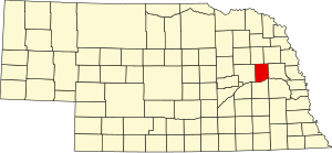 Location within the U.S. state of Nebraska | |
 Nebraska's location within the U.S. | |
| Coordinates: 41°35′N 97°05′W / 41.58°N 97.09°W | |
| Country | |
| State | |
| Founded | 1869 |
| Named for | Schuyler Colfax |
| Seat | Schuyler |
| Largest city | Schuyler |
| Area | |
| • Total | 417 sq mi (1,080 km2) |
| • Land | 412 sq mi (1,070 km2) |
| • Water | 4.9 sq mi (13 km2) 1.2%% |
| Population | |
| • Estimate (2018) | 10,881 |
| • Density | 25.7/sq mi (9.9/km2) |
| Time zone | UTC−6 (Central) |
| • Summer (DST) | UTC−5 (CDT) |
| Congressional district | 1st |
| Website | www |


Colfax County is a county in the U.S. state of Nebraska. As of the 2010 United States Census, the population was 10,515.[1] Its county seat is Schuyler.[2] The county and its seat are named after US Vice President (1869-1873) Schuyler Colfax.[3]
In the Nebraska license plate system, Colfax County is represented by the prefix 43 (it had the 43rd largest number of vehicles registered in the county when the license plate system was established in 1922).
History[]
Colfax County was established by the Nebraska legislature in 1869, as part of the division of Platte County into three parts. The new county was named for Schuyler Colfax, then the Vice-President of the United States. The site of Shell Creek Station on the Union Pacific Railroad was chosen as the county seat, and renamed Schuyler also after Colfax.[4] Schuyler was incorporated in 1870, and the county's first courthouse was constructed in 1872.[5][6]
Colfax County in May 2020 had the sixth-highest per capita COVID-19 infection rate of any American county. About one of every 23 residents has tested positive, with 467 cases.[7] As of October 2020, one in every 13 residents has tested positive, with 798 cases. [8]
Geography[]
According to the US Census Bureau, the county has an area of 417 square miles (1,080 km2), of which 412 square miles (1,070 km2) is land and 4.9 square miles (13 km2) (1.2%) is water.[9]
Major highways[]
Adjacent counties[]
- Dodge County – east
- Butler County – south
- Platte County – west
- Stanton County – north
- Cuming County – northeast
Demographics[]
| Historical population | |||
|---|---|---|---|
| Census | Pop. | %± | |
| 1870 | 1,424 | — | |
| 1880 | 6,588 | 362.6% | |
| 1890 | 10,453 | 58.7% | |
| 1900 | 11,211 | 7.3% | |
| 1910 | 11,610 | 3.6% | |
| 1920 | 11,624 | 0.1% | |
| 1930 | 11,434 | −1.6% | |
| 1940 | 10,627 | −7.1% | |
| 1950 | 10,010 | −5.8% | |
| 1960 | 9,595 | −4.1% | |
| 1970 | 9,498 | −1.0% | |
| 1980 | 9,890 | 4.1% | |
| 1990 | 9,139 | −7.6% | |
| 2000 | 10,441 | 14.2% | |
| 2010 | 10,515 | 0.7% | |
| 2018 (est.) | 10,881 | [10] | 3.5% |
| US Decennial Census[11] 1790-1960[12] 1900-1990[13] 1990-2000[14] 2010-2013[1] | |||
As of the 2000 United States Census,[15] there were 10,441 people, 3,682 households, and 2,592 families in the county. The population density was 25 people per square mile (10/km2). There were 4,088 housing units at an average density of 10 per square mile (4/km2). The racial makeup of the county was 81.73% White, 0.07% Black or African American, 0.19% Native American, 0.20% Asian, 0.14% Pacific Islander, 15.94% from other races, and 1.73% from two or more races. 26.17% of the population were Hispanic or Latino of any race. 28.8% were of German and 24.2% Czech ancestry.
The said that the county was 47.4 , 3.5 black African American, .5% Asian and 47.2% Hispanic.
There were 3,682 households, out of which 35.60% had children under the age of 18 living with them, 58.90% were married couples living together, 7.10% had a female householder with no husband present, and 29.60% were non-families. 25.70% of all households were made up of individuals, and 15.40% had someone living alone who was 65 years of age or older. The average household size was 2.80 and the average family size was 3.31.
The county population contained 28.90% under the age of 18, 8.50% from 18 to 24, 27.90% from 25 to 44, 18.70% from 45 to 64, and 16.00% who were 65 years of age or older. The median age was 35 years. For every 100 females there were 106.40 males. For every 100 females age 18 and over, there were 105.70 males.
The median income for a household in the county was $35,849, and the median income for a family was $40,936. Males had a median income of $25,656 versus $20,485 for females. The per capita income for the county was $15,148. About 7.20% of families and 10.80% of the population were below the poverty line, including 13.80% of those under age 18 and 7.90% of those age 65 or over.
Communities[]
Politics[]
Colfax County voters are reliably Republican. In only one national election since 1936 did the county select the Democratic Party candidate.
See also[]
References[]
- ^ Jump up to: a b "State & County QuickFacts". US Census Bureau. Archived from the original on July 8, 2011. Retrieved September 17, 2013.
- ^ "Find a County". National Association of Counties. Archived from the original on 31 May 2011. Retrieved 7 June 2011.
- ^ Bain, David Haward (2004). The Old Iron Road: An Epic of Rails, Roads, and the Urge to Go West. New York City NY: Penguin Books. pp. 65–6. ISBN 0-14-303526-6.
- ^ Bowman, J. R. (1882). Shearer, Frederick E. (ed.). The Pacific tourist. J.R. Bowman's illustrated transcontinental guide of travel from the Atlantic to the Pacific Ocean. New York: J.R. Bowman. p. 26. OCLC 752667534. Retrieved 9 May 2018.
- ^ "Colfax County History". www.colfaxne.com. Retrieved December 8, 2017.
- ^ Griepentrog, Harold. "Schuyler: Colfax County".
- ^ See https://www.nytimes.com/interactive/2020/us/coronavirus-us-cases.html "Coronavirus in the U.S.: Latest Map and Case Count" The New York Times May 15, 2020.]
- ^ Times, The New York. "Nebraska Covid Map and Case Count". The New York Times. ISSN 0362-4331. Retrieved 2020-10-04.
- ^ "2010 Census Gazetteer Files". US Census Bureau. August 22, 2012. Archived from the original on November 13, 2013. Retrieved December 6, 2014.
- ^ "Population and Housing Unit Estimates". Retrieved December 26, 2019.
- ^ "US Decennial Census". US Census Bureau. Retrieved December 6, 2014.
- ^ "Historical Census Browser". University of Virginia Library. Retrieved December 6, 2014.
- ^ "Population of Counties by Decennial Census: 1900 to 1990". US Census Bureau. Retrieved December 6, 2014.
- ^ "Census 2000 PHC-T-4. Ranking Tables for Counties: 1990 and 2000" (PDF). US Census Bureau. Retrieved December 6, 2014.
- ^ "U.S. Census website". US Census Bureau. Retrieved 31 January 2008.
- ^ Election Results
| show Places adjacent to Colfax County, Nebraska |
|---|
| show Municipalities and communities of Colfax County, Nebraska, United States |
|---|

Coordinates: 41°35′N 97°05′W / 41.58°N 97.09°W
| show Authority control |
|---|
- Nebraska counties
- Colfax County, Nebraska
- 1869 establishments in Nebraska
- Populated places established in 1869