Frontier County, Nebraska
Frontier County | |
|---|---|
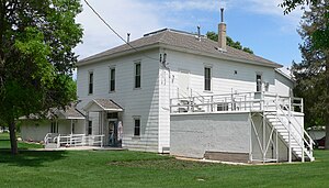 Frontier County Courthouse in Stockville | |
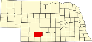 Location within the U.S. state of Nebraska | |
 Nebraska's location within the U.S. | |
| Coordinates: 40°32′N 100°23′W / 40.53°N 100.39°W | |
| Country | |
| State | |
| Founded | 1872 |
| Seat | Stockville |
| Largest city | Curtis |
| Area | |
| • Total | 980 sq mi (2,500 km2) |
| • Land | 975 sq mi (2,530 km2) |
| • Water | 5.5 sq mi (14 km2) 0.6%% |
| Population | |
| • Estimate (2017) | 2,631 |
| • Density | 2.7/sq mi (1.0/km2) |
| Time zone | UTC−6 (Central) |
| • Summer (DST) | UTC−5 (CDT) |
| Congressional district | 3rd |
| Website | www |

Frontier County is a county in the U.S. state of Nebraska. As of the 2010 United States Census, the population was 2,756.[1] Its county seat is Stockville.[2]
In the Nebraska license plate system, Frontier County is represented by the prefix 60 (it had the sixtieth-largest number of vehicles registered in the county when the license plate system was established in 1922).
History[]
Frontier County was formed in 1872.[3] It was named for its location along the frontier border in the late 19th century.[4]
The courthouse was completed in 1889.[5]
Geography[]
According to the US Census Bureau, the county has an area of 980 square miles (2,500 km2), of which 975 square miles (2,530 km2) is land and 5.5 square miles (14 km2) (0.6%) is water.[6]
Major highways[]
 U.S. Highway 83
 Nebraska Highway 18
 Nebraska Highway 21
 Nebraska Highway 23
Adjacent counties[]
- Gosper County – east
- Furnas County –southeast
- Red Willow County – south
- Hitchcock County – southwest
- Hayes County – west
- Lincoln County – north
- Dawson County – northeast
Protected areas[]
- Hugh Butler Lake / Red Willow Reservoir State Wildlife Management Area (part)[7]
- Medicine Creek Reservoir State Recreation Area[8]
Demographics[]
| Historical population | |||
|---|---|---|---|
| Census | Pop. | %± | |
| 1880 | 934 | — | |
| 1890 | 8,497 | 809.7% | |
| 1900 | 8,781 | 3.3% | |
| 1910 | 8,572 | −2.4% | |
| 1920 | 8,540 | −0.4% | |
| 1930 | 8,114 | −5.0% | |
| 1940 | 6,417 | −20.9% | |
| 1950 | 5,282 | −17.7% | |
| 1960 | 4,311 | −18.4% | |
| 1970 | 3,982 | −7.6% | |
| 1980 | 3,647 | −8.4% | |
| 1990 | 3,101 | −15.0% | |
| 2000 | 3,099 | −0.1% | |
| 2010 | 2,756 | −11.1% | |
| 2017 (est.) | 2,631 | [9] | −4.5% |
| US Decennial Census[10] 1790-1960[11] 1900-1990[12] 1990-2000[13] 2010-2013[1] | |||
As of the 2000 United States Census,[14] there were 3,099 people, 1,192 households, and 828 families in the county. The population density was 3 people per square mile (1/km2). There were 1,543 housing units at an average density of 2 per square mile (1/km2). The racial makeup of the county was 98.29% White, 0.10% Black or African American, 0.26% Native American, 0.26% Asian, 0.39% from other races, and 0.71% from two or more races. 0.97% of the population were Hispanic or Latino of any race. 45.8% were of German, 12.8% English, 6.3% American and 6.1% Irish ancestry.
There were 1,192 households, out of which 31.40% had children under the age of 18 living with them, 62.50% were married couples living together, 4.80% had a female householder with no husband present, and 30.50% were non-families. 26.30% of all households were made up of individuals, and 12.30% had someone living alone who was 65 years of age or older. The average household size was 2.48 and the average family size was 3.02.
The county population contained 26.00% under the age of 18, 11.30% from 18 to 24, 22.80% from 25 to 44, 23.00% from 45 to 64, and 16.90% who were 65 years of age or older. The median age was 38 years. For every 100 females there were 100.50 males. For every 100 females age 18 and over, there were 98.50 males.
The median income for a household in the county was $33,038, and the median income for a family was $38,664. Males had a median income of $25,792 versus $16,941 for females. The per capita income for the county was $16,648. About 9.30% of families and 12.20% of the population were below the poverty line, including 9.90% of those under age 18 and 8.30% of those age 65 or over.
Communities[]
- Curtis
- Eustis
- Freedom
- Maywood
- Moorefield
- Orafino
- Stockville (county seat)
Politics[]
Frontier County voters are strongly Republican. In no national election since 1936 has the county selected the Democratic Party candidate (as of 2020). The polarization has increased in recent years with Republican candidate Donald Trump winning 85.0% of the vote in 2020, a record in the county.
See also[]
- National Register of Historic Places listings in Frontier County, Nebraska
References[]
- ^ Jump up to: a b "State & County QuickFacts". US Census Bureau. Archived from the original on June 7, 2011. Retrieved September 19, 2013.
- ^ "Find a County". National Association of Counties. Archived from the original on 31 May 2011. Retrieved 7 June 2011.
- ^ Burr, George L. (1921). History of Hamilton and Clay Counties, Nebraska, Vol. 1. S.J. Clarke Pub. Co. p. 110.
- ^ Gannett, Henry (1905). The Origin of Certain Place Names in the United States. Govt. Print. Off. p. 132.
- ^ "Stockville, Frontier County". Center for Advanced Land Management Information Technologies. University of Nebraska. Retrieved 9 August 2014.
- ^ "2010 Census Gazetteer Files". US Census Bureau. August 22, 2012. Archived from the original on November 13, 2013. Retrieved December 7, 2014.
- ^ Red Willow Reservoir State Wildlife Management Area, McCook NE Google Maps (accessed 21 January 2019)
- ^ Medicine Creek Reservoir State Recreation Area Google Maps (accessed 21 January 2019)
- ^ "Population and Housing Unit Estimates". Retrieved 21 January 2019.
- ^ "US Decennial Census". US Census Bureau. Retrieved December 7, 2014.
- ^ "Historical Census Browser". University of Virginia Library. Retrieved December 7, 2014.
- ^ "Population of Counties by Decennial Census: 1900 to 1990". US Census Bureau. Retrieved December 7, 2014.
- ^ "Census 2000 PHC-T-4. Ranking Tables for Counties: 1990 and 2000" (PDF). US Census Bureau. Retrieved December 7, 2014.
- ^ "U.S. Census website". US Census Bureau. Retrieved 31 January 2008.
- ^ Election Results
- ^ The leading "other" candidate, Progressive Theodore Roosevelt, received 579 votes, while Socialist candidate Eugene Debs received 120 votes and Prohibition Eugene Chafin received 37 votes.
| show Places adjacent to Frontier County, Nebraska |
|---|
| show Municipalities and communities of Frontier County, Nebraska, United States |
|---|

Coordinates: 40°32′N 100°23′W / 40.53°N 100.39°W
| show Authority control |
|---|
- Nebraska counties
- Frontier County, Nebraska
- 1872 establishments in Nebraska
- Populated places established in 1872