Sahla Tahtania
Sahla Tahtania | |
|---|---|
Village | |
 Sahla Tahtania | |
| Coordinates: 27°16′39″N 2°29′25″E / 27.27750°N 2.49028°ECoordinates: 27°16′39″N 2°29′25″E / 27.27750°N 2.49028°E | |
| Country | |
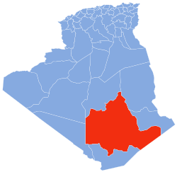
| Province | Tamanrasset Province |
| District | In Salah District |
| Commune | In Salah[1] |
| Elevation | 275 m (902 ft) |
| Time zone | UTC+1 (CET) |

Sahla Tahtania (also written Sahela Tahtania) is a village in the commune of In Salah,[1] in In Salah District, Tamanrasset Province, Algeria. It is located just to the west of the N1 national highway, 9 kilometres (5.6 mi) north of the town of In Salah.[2]
References[]
- ^ Jump up to: a b "Décret n° 84-365, fixant la composition, la consistance et les limites territoriale des communes. Wilaya d'El Oued" (PDF) (in French). Journal officiel de la République Algérienne. 19 December 1984. p. 1495. Archived from the original (PDF) on 2 March 2013 or before. Retrieved 6 June 2013. Check date values in:
|archivedate=(help) - ^ "Sahela Tahtania, Algeria". Geonames.org. Retrieved 20 June 2013.
Neighbouring towns and cities
| show Places adjacent to Sahla Tahtania |
|---|
This article about a location in Tamanrasset Province is a stub. You can help Wikipedia by . |
Categories:
- Populated places in Tamanrasset Province
- Algeria geography stubs