Adrar Province
Adrar Province
ولاية أدرار | |
|---|---|
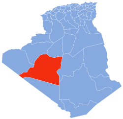 Map of Algeria highlighting Adrar | |
| Coordinates: 27°52′50″N 0°17′50″W / 27.88056°N 0.29722°WCoordinates: 27°52′50″N 0°17′50″W / 27.88056°N 0.29722°W | |
| Country | |
| Capital | Adrar |
| Government | |
| • PPA president | Mr. Menad Mehdi (FLN) |
| • Wāli | Mr. Messaoud Djari |
| Area | |
| • Total | 424,948 km2 (164,073 sq mi) |
| Elevation | 276 m (906 ft) |
| Population (2008)[1] | |
| • Total | 402,197 |
| • Density | 0.95/km2 (2.5/sq mi) |
| Time zone | UTC+01 (CET) |
| Area Code | +213 (0) 49 |
| ISO 3166 code | DZ-01 |
| Districts | 11 |
| Municipalities | 28 |

Adrar (Arabic: ولاية أدرار, Berber languages: ⴰⴷⵔⴰⵔ) is a province (wilaya) in southwestern Algeria, named after its capital Adrar. It is the second-largest province, with an area of 424,948 km², roughly the size of the US state of California. It had 402,197 inhabitants at the 2008 population census.[1]
It is bordered by five other wilayas: to the west by Tindouf; to the north by Béchar and El Bayadh; to the east by Ghardaïa and Tamanrasset. To the south, it is bordered by Mauritania and Mali.
Adrar is composed of three natural and cultural regions: Touat (Adrar, Zaouiet Kounta), Gourara (Aougrout, Timimoune) and (Aoulef), and 299 ksour.
History[]
The province was created from parts of the and in 1974.
Geography[]
Location[]
The province of Adrar is located in south-west Algeria.
| show Places adjacent to Adrar Province |
|---|
Administrative divisions[]
The province comprises 7 districts (daïras) and 16 communes or municipalities (baladiyahs)
The following table shows the list of districts in the province of Adrar and all the communes in each district.
| District | Number of communes |
Communes | Area (km²) |
Population |
|---|---|---|---|---|
| Adrar | 3 | Adrar • Bouda • Ouled Ahmed Timmi (Ouled Ahmed Temmi) | 9,423 | 64,547 |
| Aoulef | 4 | Akabli • Aoulef • Timokten • Tit | 23,936 | 40,036 |
| Fenoughil | 3 | Fenoughil • Tamentit • Tamest | 20,970 | 24,532 |
| Reggane | 2 | Reggane • Sali | 140,981 | 25,483 |
| T'Sabit | 2 | Sebaa • Tsabit | 19,446 | 13,821 |
| Zaouiet Kounta | 2 | Zaouiet Kounta • In Zghmir | 15,100 | 28,593 |
Districts[]
Communes[]
| No.[2][3] | Commune [2][3] | Arabic [2] | Population [3] |
|---|---|---|---|
| 01 | Adrar | أدرار | 43,903 |
| 02 | Tamest | تامست | 6,658 |
| 03 | Charouine | شروين | 8,678 |
| 04 | Reggane | رقان | 14,179 |
| 05 | In Zghmir | ان زقمير | 14,062 |
| 06 | Tit | تيط | 3,160 |
| 07 | Ksar Kaddour | قصر قدور | 3,500 |
| 08 | Tsabit | تسابيت | 11,832 |
| 09 | Timimoun (Timmimoun) | تيميمون | 28,595 |
| 10 | Ouled Said | أوالد السعيد | 7,538 |
| 11 | Zaouiet Kounta | زاوية كنتة | 14,531 |
| 12 | Aoulef | أولف | 15,229 |
| 13 | Timokten (Timoktene, Timekten, Tamekten) | تمقطن | 14,134 |
| 14 | Tamentit (Tamantit) | تمنطيط | 7,912 |
| 15 | Fenoughil | فنوغيل | 9,962 |
| 16 | Tinerkouk | تينركوك | 13,393 |
| 17 | Deldoul | دلدول | 7,465 |
| 18 | Sali | سالى | 11,304 |
| 19 | Akabli | أقبلى | 7,513 |
| 20 | Metarfa | الطارفة | 7,061 |
| 21 | Ouled Ahmed Timmi (Ouled Ahmed Temmi) | أوالد أحمد تيمى | 11,976 |
| 22 | Bouda | بودة | 8,668 |
| 23 | Aougrout | أوقروت | 9,878 |
| 24 | Talmine | طلمين | 9,469 |
| 25 | Bordj Badji Mokhtar | برج باجى مختار | 9,323 |
| 26 | Sebaa (Sbaa) | السبع | 1,989 |
| 27 | Ouled Aissa | أوالد عيسى | 5,497 |
| 28 | Timiaouine | تيمياوين | 4,206 |
See also[]
References[]
- ^ Jump up to: a b Office National des Statistiques, Recensement General de la Population et de l’Habitat 2008 Archived July 24, 2008, at the Wayback Machine Preliminary results of the 2008 population census. Accessed on 2008-07-02.
- ^ Jump up to: a b c (in French) "Code Geographique National" (PDF). 5ème Recensement General de la Population et de l’Habitat (in Arabic). 2008. Archived from the original (PDF) on 2010-11-13.
- ^ Jump up to: a b c "Répartition des Sièges des Assemblées Populaires Communales: 01 — Wilaya d'Adrar" (PDF). Journal Officiel de la République Algérienne (in French) (47). 10 July 2002.
External links[]
| show Authority control |
|---|
- Adrar Province
- Provinces of Algeria
- States and territories established in 1974