Tiaret Province
Tiaret Province
ولاية تيارت | |
|---|---|
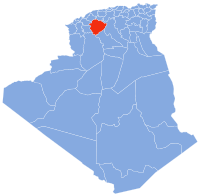
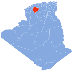 Map of Algeria highlighting Tiaret | |
| Coordinates: 35°23′N 01°20′E / 35.383°N 1.333°ECoordinates: 35°23′N 01°20′E / 35.383°N 1.333°E | |
| Country | |
| Capital | Tiaret |
| Area | |
| • Total | 20,673 km2 (7,982 sq mi) |
| Population (2008)[1] | |
| • Total | 842,060 |
| • Density | 41/km2 (110/sq mi) |
| Time zone | UTC+01 (CET) |
| Area Code | +213 (0) 46 |
| ISO 3166 code | DZ-14 |
| Districts | 14 |
| Municipalities | 42 |

Tiaret (Arabic: ولاية تيارت) is a province (wilaya) of Algeria. The capital is Tiaret.
History[]
The province was created from El Asnam department and Tiaret department in 1974.
In 1984 Tissemsilt Province is carved out of its territory.
Administrative division[]
The province is divided into 14 districts (daïras), which are further divided into 42 communes or municipalities.
Districts[]
Communes[]
- Aïn Bouchekif
- Aïn Deheb
- Aïn El Hadid
- Aïn Kermes
- Aïn Zarit
- Bougara
- Chehaima
- Dahmouni
- Djebilet Rosfa
- Djillali Ben Omar
- Faidja
- Frenda
- Guertoufa
- Hamadia
- Ksar Chellala
- Madna
- Mahdia
- Mechraa Safa
- Medrissa
- Medroussa
- Meghila
- Mellakou
- Nadorah
- Naima
- Oued Lilli
- Rahouia
- Rechaiga
- Sebaine
- Sebt
- Serghine
- Si Abdelghani
- Sidi Abderrahmane
- Sidi Ali Mellal
- Sidi Bakhti
- Sidi Hosni
- Sougueur
- Tagdemt
- Takhemaret
- Tiaret
- Tidda
- Tousnina
- Zmalet El Emir Abdelkader
References[]
- ^ Office National des Statistiques, Recensement General de la Population et de l’Habitat 2008 Archived 2008-07-24 at the Wayback Machine Preliminary results of the 2008 population census. Accessed on 2008-07-02.
External links[]
- (in French) Official website
| show Authority control |
|---|
This article about a location in Tiaret Province is a stub. You can help Wikipedia by . |
Categories:
- Tiaret Province
- Provinces of Algeria
- States and territories established in 1974
- Algeria geography stubs