Tamanrasset Province
Tamanrasset Province
ولاية تمنراست | |
|---|---|
| Province of Tamanrasset | |
 | |
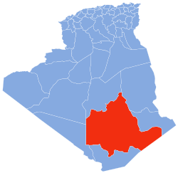 Map of Algeria highlighting Tamanrasset | |
| Coordinates: 22°47′N 05°31′E / 22.783°N 5.517°ECoordinates: 22°47′N 05°31′E / 22.783°N 5.517°E | |
| Country | |
| Capital | Tamanrasset |
| Government | |
| • Governor | Shater Abdel Karim |
| Area | |
| • Total | 667,667 km2 (257,788 sq mi) |
| Area rank | 1st |
| Elevation | 1,400 m (4,600 ft) |
| Highest elevation | 3,303 m (10,837 ft) |
| Population (2008)[1] | |
| • Total | 115,043 (within current boundaries) |
| • Rank | 50th |
| Time zone | UTC+01 (CET) |
| Area Code | +213 (0) 29 |
| ISO 3166 code | DZ-11 |
| Districts | 3 |
| Municipalities | 5 |

Tamanrasset or Tamanghasset (Arabic: ولاية تمنراست Wilāya Tamanrāssat, Berber languages: is the largest province (wilaya) in Algeria. It was named after its province seat, Tamanrasset. The province has two national parks, more than any other in Algeria. They are Tassili n'Ajjer National Park and Ahaggar National Park. The province is the largest in Algeria as it is 667,667 km² large, comparable to Texas or Finland or Malaysia ekip.
Geography[]
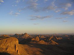
It is located in the deep southern region of Algeria and is 2000 km south of Algiers (capital of Algeria). On the north it is bordered by In Salah Province, on the north-east by Illizi Province, on the east by Djanet Province, on the south by In Guezzam Province, and on the west by Adrar Province, the second largest province by area, and Bordj Badji Mokhtar Province. Tamanrasset also has an international border with Niger. The province is the largest Algerian province with area of 336,854 km2 (130,060 sq mi) although it is located in the heart of the desert. The Province of Tamanrasset has a moderate climate because of its mountainous terrain. The province has an elevation of 1,400 meters. The highest point of Tamanrasset Province is Mount Tahat, which is also the highest point of Algeria with 3,303 meters. The most well known tourist destination is the Tomb of Tinhan.
History[]
The province was created from Oasis department in 1974.
Administrative divisions[]
The province is divided into 3 districts (daïras),[2] which are further divided into 5 communes or municipalities.
| District | Commune | Arabic |
|---|---|---|
| Abalessa District | Abalessa | أبلسة |
| Tamanrasset District | In Amguel | عين امقل |
| Tamanrasset | تامنراست | |
| Tazrouk District | Idlès | إدلس |
| Tazrouk | تاظروك |
See also[]
References[]
- ^ Office National des Statistiques, Recensement General de la Population et de l’Habitat 2008 Archived 2008-07-24 at the Wayback Machine Preliminary results of the 2008 population census. Accessed on 2008-07-02.
- ^ "The official journal of People's Democratic Republic of Algeria" (PDF). SGG Algeria. Retrieved 2007-11-06.
| show Authority control |
|---|
This article about a location in Tamanrasset Province is a stub. You can help Wikipedia by . |
- Tamanrasset Province
- Tuareg
- Provinces of Algeria
- States and territories established in 1974
- Algeria geography stubs