Saint-Remy-sous-Broyes
Saint-Remy-sous-Broyes | |
|---|---|
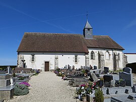 The church in Saint-Remy-sous-Broyes | |
show Location of Saint-Remy-sous-Broyes | |
 Saint-Remy-sous-Broyes | |
| Coordinates: 48°42′09″N 3°46′30″E / 48.7025°N 3.775°ECoordinates: 48°42′09″N 3°46′30″E / 48.7025°N 3.775°E | |
| Country | France |
| Region | Grand Est |
| Department | Marne |
| Arrondissement | Épernay |
| Canton | Sézanne-Brie et Champagne |
| Government | |
| • Mayor (2020–2026) | Dany Carton[1] |
| Area 1 | 7.75 km2 (2.99 sq mi) |
| Population (Jan. 2018)[2] | 105 |
| • Density | 14/km2 (35/sq mi) |
| Time zone | UTC+01:00 (CET) |
| • Summer (DST) | UTC+02:00 (CEST) |
| INSEE/Postal code | 51514 /51120 |
| 1 French Land Register data, which excludes lakes, ponds, glaciers > 1 km2 (0.386 sq mi or 247 acres) and river estuaries. | |


Saint-Remy-sous-Broyes (French pronunciation: [sɛ̃ ʁemi su bʁwa], literally Saint-Remy under Broyes) is a commune in the Marne department in north-eastern France.
See also[]
References[]
- ^ Maires au 17-06-2020, data.gouv.fr, accessed 1 December 2020
- ^ "Populations légales 2018". INSEE. 28 December 2020.
| Wikimedia Commons has media related to Saint-Remy-sous-Broyes. |
This Marne geographical article is a stub. You can help Wikipedia by . |
Categories:
- Communes of Marne (department)
- Marne (department) geography stubs