Saint-Roch-des-Aulnaies
show This article may be expanded with text translated from the corresponding article in French. (December 2017) Click [show] for important translation instructions. |
Saint-Roch-des-Aulnaies | |
|---|---|
Parish municipality | |
 | |
 Location within L'Islet RCM | |
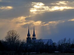
 Saint-Roch-des-Aulnaies Location in southern Quebec | |
| Coordinates: 47°19′N 70°11′W / 47.317°N 70.183°WCoordinates: 47°19′N 70°11′W / 47.317°N 70.183°W[1] | |
| Country | |
| Province | |
| Region | Chaudière-Appalaches |
| RCM | L'Islet |
| Constituted | July 1, 1855 |
| Government | |
| • Mayor | Michel Castonguay |
| • Federal riding | Montmagny—L'Islet— Kamouraska—Rivière- du-Loup |
| • Prov. riding | Côte-du-Sud |
| Area | |
| • Total | 162.40 km2 (62.70 sq mi) |
| • Land | 49.25 km2 (19.02 sq mi) |
| Population | |
| • Total | 967 |
| • Density | 19.6/km2 (51/sq mi) |
| • Pop 2006-2011 | |
| • Dwellings | 533 |
| Postal code(s) | G0R 4E0 |
| Area code(s) | 418 and 581 |
| Highways | |
| Website | www.saintroch desaulnaies.ca |

Saint-Roch-des-Aulnaies is a parish municipality in Quebec, Canada.
See also[]
References[]
- ^ Reference number 57597 of the Commission de toponymie du Québec (in French)
- ^ Jump up to: a b Geographic code 17065 in the official Répertoire des municipalités (in French)
- ^ Jump up to: a b "(Code 2417065) Census Profile". 2011 census. Statistics Canada. 2012.
External links[]
 Media related to Saint-Roch-des-Aulnaies at Wikimedia Commons
| show Adjacent Municipal Subdivisions |
|---|
| hide | |
|---|---|
| Cities & Towns | |
| Municipalities | |
| Parishes |
|
| |
| show Authority control |
|---|
This Chaudière-Appalaches location article is a stub. You can help Wikipedia by . |
Categories:
- Parish municipalities in Quebec
- Incorporated places in Chaudière-Appalaches
- Chaudière-Appalaches geography stubs