Sakaiminato, Tottori
This article needs additional citations for verification. (January 2009) |
Sakaiminato
境港市 | |
|---|---|
 Sakaiminato city | |
 Flag  Seal | |
 Location of Sakaiminato in Tottori Prefecture | |
 Sakaiminato Location in Japan | |
| Coordinates: 35°32′N 133°14′E / 35.533°N 133.233°ECoordinates: 35°32′N 133°14′E / 35.533°N 133.233°E | |
| Country | Japan |
| Region | Chūgoku (San'in) |
| Prefecture | Tottori Prefecture |
| Government | |
| • Mayor | |
| Area | |
| • Total | 29.02 km2 (11.20 sq mi) |
| Population (1 June 2016) | |
| • Total | 33,888 |
| • Density | 1,200/km2 (3,000/sq mi) |
| Time zone | UTC+09:00 (JST) |
| City hall address | 3000, Agarimichichō, Sakaiminato-shi, Tottori-ken 684-8501 |
| Website | www |
| Symbols | |
| Flower | Chrysanthemum |
| Tree | Japanese Black Pine |

Sakaiminato (境港市, Sakaiminato-shi) is a city in Tottori Prefecture, Japan.[1]
History[]
An Imperial decree in July 1899 established Sakai as an open port for trading with the United States and the United Kingdom.[2]
Sakaiminato was founded on April 1, 1956. A merger with Yonago and other neighboring municipalities was proposed, but the majority of the citizenry voted against this, and Sakaiminato remained an autonomous municipality.[citation needed]
Geography[]
At the northern end of Yumigahama Peninsula, it is surrounded by the Miho Bay on the Sea of Japan to the east, Lake Nakaumi to the west and the in the north, which also makes up the border with Shimane Prefecture and its capital Matsue.[citation needed]
In 2008, Sakaiminato had an estimated population of 35,710 and a population density of 1,240 persons per km2. The total area is 28.79 km2 (11.12 sq mi).[citation needed]
Economy[]
The seaport of Sakaiminato has a long history as a seaport for the San'in Region. Following World War II the city has served as the base of the fishing industry for all of Western Japan. Consequently, marine product processing is also a major industry in the city.[3]
Transportation[]
Yonago Airport is in Sakaiminato and is the busiest airport in Tottori Prefecture.[3] Nearby , next to the airport, is run by the Ministry of Defence. Asiana Airlines operates a sales office in Sakaiminato.[4]
Sakaiminato is linked to the Japanese railway network by the Sakai Line branch, which runs between Sakaiminato Station and Yonago Station on the San'in Main Line.[5]
The port at Sakaiminato serves the DBS Cruise ferry Eastern Dream, which connects Japan to Donghae, South Korea, and Vladivostok, Russia.[6]
Twin towns – sister cities[]
Sakaiminato is twinned with:[7]
 Hunchun, China
Notable residents[]
Sakaiminato is the home of Shigeru Mizuki, the creator of GeGeGe no Kitaro, a character seen in many forms throughout Japan. The spirit of Kitaro can be found in Sakaiminato, on Kitaro Road, a street dedicated to all the characters that appear in Mizuki's stories. One hundred bronze statues of the story's characters line both sides of the road.[citation needed]
Sakaiminato was also where the photographer Shōji Ueda was born and ran a studio.[citation needed]
Gallery[]
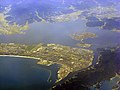
Aerial view of part of Sakaiminato.

Eshima Ohashi Bridge links Sakaiminato and Matsue across a narrow channel.

References[]
- ^ The name of Sakaiminato in the Japanese language is formed from two kanji characters. The first, 境, means "border", and the second, 港 means "port".
- ^ US Department of State. (1906). A digest of international law as embodied in diplomatic discussions, treaties and other international agreements (John Bassett Moore, ed.), Vol. 5, p. 759.
- ^ Jump up to: a b "Kurayoshi Plain". Encyclopedia of Japan. Tokyo: Shogakukan. 2012. Archived from the original on 2007-08-25. Retrieved 2012-04-12.
- ^ "Worldwide Offices Japan." Asiana Airlines. Retrieved on 2009-01-19 from http://us.flyasiana.com/Global/US/en/homepage?cmd=&fid=ABOUT13000®ion=JP&city=&searchWrd=#01.
- ^ "Sakaiminato/Yonago". Japan: The Official Guide. Japan National Tourism Organization. Retrieved 2015-06-24.
- ^ "DBS Cruise Ferry Sakaiminato - Donghae - Vladivostok". DBS Cruise Ferry. Retrieved 2015-06-24.
- ^ "境港市の友好都市". city.sakaiminato.lg.jp (in Japanese). Sakaiminato. Retrieved 2020-11-12.
External links[]
 Media related to Sakaiminato, Tottori at Wikimedia Commons
- Sakaiminato City official web site (in Japanese)
- Sakaiminato City official web site (in English)
| show Authority control |
|---|
- Cities in Tottori Prefecture
- Port settlements in Japan
- Populated coastal places in Japan