San-Nicolao
show This article may be expanded with text translated from the corresponding article in French. (December 2008) Click [show] for important translation instructions. |
San Nicolao | |
|---|---|
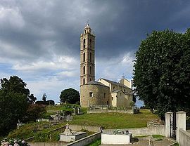 The parish church of Saint-Nicolas | |
show Location of San Nicolao | |
 San Nicolao | |
| Coordinates: 42°22′30″N 9°31′15″E / 42.375°N 9.5208°ECoordinates: 42°22′30″N 9°31′15″E / 42.375°N 9.5208°E | |
| Country | France |
| Region | Corsica |
| Department | Haute-Corse |
| Arrondissement | Corte |
| Canton | Castagniccia |
| Intercommunality | Costa Verde |
| Government | |
| • Mayor (2020–2026) | Marie-Thérèse Olivesi[1] |
| Area 1 | 7.73 km2 (2.98 sq mi) |
| Population (Jan. 2018)[2] | 2,031 |
| • Density | 260/km2 (680/sq mi) |
| Time zone | UTC+01:00 (CET) |
| • Summer (DST) | UTC+02:00 (CEST) |
| INSEE/Postal code | 2B313 /20230 |
| Elevation | 0–922 m (0–3,025 ft) (avg. 250 m or 820 ft) |
| 1 French Land Register data, which excludes lakes, ponds, glaciers > 1 km2 (0.386 sq mi or 247 acres) and river estuaries. | |


San-Nicolao is a commune in the Haute-Corse department of France on the island of Corsica.
Population[]
| Year | Pop. | ±% |
|---|---|---|
| 1962 | 573 | — |
| 1968 | 682 | +19.0% |
| 1975 | 731 | +7.2% |
| 1982 | 867 | +18.6% |
| 1990 | 1,061 | +22.4% |
| 1999 | 1,316 | +24.0% |
| 2008 | 1,543 | +17.2% |
Geography[]
San Nicolao is located in the east side of the island.
See also[]
- Communes of the Haute-Corse department
References[]
- ^ "Répertoire national des élus: les maires". data.gouv.fr, Plateforme ouverte des données publiques françaises (in French). 2 December 2020.
- ^ "Populations légales 2018". INSEE. 28 December 2020.
| Wikimedia Commons has media related to San-Nicolao (Haute-Corse). |
| show Communes of the Haute-Corse department |
|---|
| show Authority control |
|---|
This Haute-Corse geographical article is a stub. You can help Wikipedia by . |
Categories:
- Communes of Haute-Corse
- Haute-Corse geography stubs