San Diego
San Diego, California | |
|---|---|
City | |
| City of San Diego | |
     From top, left to right: Downtown, La Jolla, Casa de Balboa, Old Point Loma lighthouse, Presidio Park | |
 Seal | |
| Nickname(s): "America's Finest City", "Birthplace of California", "City in Motion"[1] | |
| Motto(s): Semper Vigilans (Latin for 'Ever Vigilant') | |
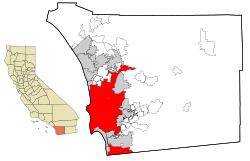 Location within San Diego County | |
 San Diego Location within California | |
| Coordinates: 32°42′54″N 117°09′45″W / 32.71500°N 117.16250°WCoordinates: 32°42′54″N 117°09′45″W / 32.71500°N 117.16250°W | |
| Country | |
| State | |
| County | |
| Established | July 16, 1769 |
| Incorporated | March 27, 1850[2] |
| Named for | Saint Didacus of Alcalá |
| Government | |
| • Type | Strong mayor[3] |
| • Body | San Diego City Council |
| • Mayor | Todd Gloria (D) |
| • City Attorney | Mara Elliott (D)[4] |
| • City Council[5] | List |
| • State Assembly Members | List
|
| • State Senators | List
|
| Area | |
| • Total | 372.42 sq mi (964.56 km2) |
| • Land | 325.88 sq mi (844.02 km2) |
| • Water | 46.54 sq mi (120.54 km2) 12.68% |
| Elevation | 62 ft (19 m) |
| Highest elevation | 1,591 ft (485 m) |
| Lowest elevation | 0 ft (0 m) |
| Population (2020) | |
| • Total | 1,386,932 |
| • Rank | 8th in the United States 2nd in California |
| • Density | 4,255.96/sq mi (1,643.25/km2) |
| • Metro | 3,298,634 (17th) |
| Demonym(s) | San Diegan |
| Time zone | UTC−8 (Pacific) |
| • Summer (DST) | UTC−7 (PDT) |
| ZIP Codes[10] | 92101–92124, 92126–92132, 92134–92140, 92142, 92143, 92145, 92147, 92149–92155, 92158–92161, 92163, 92165–92179, 92182, 92186, 92187, 92190–92199 |
| Area codes | 619/858 |
| FIPS code | 06-66000 |
| GNIS feature IDs | 1661377, 2411782 |
| Website | SanDiego.gov |


San Diego (/ˌsæn diˈeɪɡoʊ/ SAN dee-AY-goh, Spanish: [san ˈdjeɣo]; Spanish for 'Saint Didacus') is a city in the U.S. state of California on the coast of the Pacific Ocean and immediately adjacent to the Mexican border. With a 2020 population of 1,386,932,[11] San Diego is the eighth most populous city in the United States and second most populous in California (after Los Angeles). The city is the county seat of San Diego County, the fifth most populous county in the United States, with 3,338,330 estimated residents as of 2019. The city is known for its mild year-round climate, natural deep-water harbor, extensive beaches and parks, long association with the United States Navy and Marine Corps, and recent emergence as a healthcare and biotechnology development center.
Historically home to the Kumeyaay people, San Diego is frequently referred to as the "Birthplace of California", as it was the first site visited and settled by Europeans on what is now the West Coast of the United States.[12] Upon landing in San Diego Bay in 1542, Juan Rodríguez Cabrillo claimed the area for Spain, forming the basis for the settlement of Alta California 200 years later. The Presidio and Mission San Diego de Alcalá, founded in 1769, formed the first European settlement in what is now California. In 1821, San Diego became part of the newly declared Mexican Empire, which reformed as the First Mexican Republic two years later. California became part of the United States in 1848 following the Mexican–American War and was admitted to the union as a state in 1850.
San Diego's main economic engines are military and defense-related activities, tourism, international trade, research, and manufacturing. The city is the economic center of the San Diego–Tijuana conurbation, the second most populous transborder metropolitan area in the western hemisphere (after Detroit–Windsor), home to an estimated 4,922,723 people as of 2012.[13] The primary border crossing between San Diego and Tijuana, the San Ysidro Port of Entry, is the busiest international land border crossing in the world outside of Asia (fourth-busiest overall). The city's primary airport, San Diego International Airport, is the busiest single-runway airport in the world.[a][14]
History[]
Spanish Empire 1769–1821
First Mexican Empire 1821–1823
United Mexican States 1823–1848
California Republic 1846
United States 1848–present
Pre-colonial period[]

The original inhabitants of the region are now known as the San Dieguito and La Jolla people.[15][16] The Kumeyaay people migrated into the area of San Diego around 1000 CE,[17][18] who erected villages scattered across the region, including the village of Cosoy (Kosa'aay) which was the Kumeyaay village that the future settlement of San Diego would stem from in today's Old Town.[19][20] The village of Cosoy was made up of thirty to forty families living in pyramid-shaped housing structures and was supported by a freshwater spring from the hillsides.[19]
Spanish period[]

The first European to visit the region was explorer Juan Rodríguez Cabrillo, sailing under the flag of Castile but possibly born in Portugal. Sailing his flagship San Salvador from Navidad, New Spain, Cabrillo claimed the bay for the Spanish Empire in 1542, and named the site "San Miguel".[21] In November 1602, Sebastián Vizcaíno was sent to map the California coast. Arriving on his flagship San Diego, Vizcaíno surveyed the harbor and what are now Mission Bay and Point Loma and named the area for the Catholic Saint Didacus, a Spaniard more commonly known as San Diego de Alcalá. On November 12, 1602, the first Christian religious service of record in Alta California was conducted by Friar Antonio de la Ascensión, a member of Vizcaíno's expedition, to celebrate the feast day of San Diego.[22]

The permanent European colonization of California and of San Diego began in 1769 with the arrival of four contingents of Spaniards from New Spain and the Baja California peninsula. Two seaborne parties reached San Diego Bay: the San Carlos, under Vicente Vila and including as notable members the engineer and cartographer Miguel Costansó and the soldier and future governor Pedro Fages, and the San Antonio, under Juan Pérez. An initial overland expedition to San Diego from the south was led by the soldier Fernando Rivera and included the Franciscan missionary, explorer, and chronicler Juan Crespí, followed by a second party led by the designated governor Gaspar de Portolà and including the mission president (and now saint) Junípero Serra.[23]
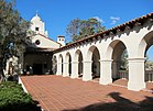
In May 1769, Portolà established the Fort Presidio of San Diego on a hill near the San Diego River above the Kumeyaay village of Cosoy,[19] which would later become incorporated into the Spanish settlement,[20] making it the first settlement by Europeans in what is now the state of California. In July of the same year, Mission San Diego de Alcalá was founded by Franciscan friars under Serra.[24][25] The mission became a site for a Kumeyaay revolt in 1775, which forced the mission to relocate six miles (10 km) up the San Diego River.[26] By 1797, the mission boasted the largest native population in Alta California, with over 1,400 neophytes living in and around the mission proper.[27] Mission San Diego was the southern anchor in Alta California of the historic mission trail El Camino Real. Both the Presidio and the Mission are National Historic Landmarks.[28][29]
Mexican period[]

In 1821, Mexico won its independence from Spain, and San Diego became part of the Mexican territory of Alta California. In 1822, Mexico began its attempt to extend its authority over the coastal territory of Alta California. The fort on Presidio Hill was gradually abandoned, while the town of San Diego grew up on the level land below Presidio Hill. The Mission was secularized by the Mexican government in 1834, and most of the Mission lands were granted to former soldiers. The 432 residents of the town petitioned the governor to form a pueblo, and Juan María Osuna was elected the first alcalde ("municipal magistrate"), defeating Pío Pico in the vote. Beyond the town, Mexican land grants expanded the number of California ranchos that modestly added to the local economy. (See, List of pre-statehood mayors of San Diego.) However, San Diego had been losing population throughout the 1830s, due to increasing tension between the settlers and the indigenous Kumeyaay and in 1838 the town lost its pueblo status because its size dropped to an estimated 100 to 150 residents.[30] The ranchos in the San Diego region would face Kumeyaay raids in the late 1830s and the town itself would face raids in the 1840s.[31]
Americans gained an increased awareness of California, and its commercial possibilities, from the writings of two countrymen involved in the often officially forbidden, to foreigners, but economically significant hide and tallow trade, where San Diego was a major port and the only one with an adequate harbor: William Shaler's "Journal of a Voyage Between China and the North-Western Coast of America, Made in 1804" and Richard Henry Dana's more substantial and convincing account, of his 1834–36 voyage, the classic Two Years Before the Mast.[32]

In 1846, the United States went to war against Mexico and sent a naval and land expedition to conquer Alta California. At first, they had an easy time of it, capturing the major ports including San Diego, but the Californios in southern Alta California struck back. Following the successful revolt in Los Angeles, the American garrison at San Diego was driven out without firing a shot in early October 1846. Mexican partisans held San Diego for three weeks until October 24, 1846, when the Americans recaptured it. For the next several months the Americans were blockaded inside the pueblo. Skirmishes occurred daily and snipers shot into the town every night. The Californios drove cattle away from the pueblo hoping to starve the Americans and their Californio supporters out. On December 1, the American garrison learned that the dragoons of General Stephen W. Kearney were at Warner's Ranch. Commodore Robert F. Stockton sent a mounted force of fifty under Captain Archibald Gillespie to march north to meet him. Their joint command of 150 men, returning to San Diego, encountered about 93 Californios under Andrés Pico. In the ensuing Battle of San Pasqual, fought in the San Pasqual Valley which is now part of the city of San Diego, the Americans suffered their worst losses in the campaign. Subsequently, a column led by Lieutenant Gray arrived from San Diego, rescuing Kearny's battered and blockaded command.[33]
Stockton and Kearny went on to recover Los Angeles and force the capitulation of Alta California with the "Treaty of Cahuenga" on January 13, 1847. As a result of the Mexican–American War of 1846–48, the territory of Alta California, including San Diego, was ceded to the United States by Mexico, under the terms of the Treaty of Guadalupe Hidalgo in 1848. The Mexican negotiators of that treaty tried to retain San Diego as part of Mexico, but the Americans insisted that San Diego was "for every commercial purpose of nearly equal importance to us with that of San Francisco," and the Mexican–American border was eventually established to be one league south of the southernmost point of San Diego Bay, so as to include the entire bay within the United States.[34]
American period[]

The state of California was admitted to the United States in 1850. That same year San Diego has designated the seat of the newly established San Diego County and was incorporated as a city. Joshua H. Bean, the last alcalde of San Diego, was elected the first mayor. Two years later the city was bankrupt;[35] the California legislature revoked the city's charter and placed it under control of a board of trustees, where it remained until 1889. A city charter was reestablished in 1889, and today's city charter was adopted in 1931.[36]
The original town of San Diego was located at the foot of Presidio Hill, in the area which is now Old Town San Diego State Historic Park. The location was not ideal, being several miles away from navigable water at its port at La Playa. In 1850, William Heath Davis promoted a new development by the bay shore called "New San Diego", several miles south of the original settlement; however, for several decades the new development consisted only of a pier, a few houses and an Army depot for the support of Fort Yuma. After 1854, the fort became supplied by sea and by steamboats on the Colorado River and the depot fell into disuse. From 1857 to 1860, San Diego became the western terminus of the San Antonio-San Diego Mail Line, the earliest overland stagecoach and mail operation from the Eastern United States to California, coming from Texas through New Mexico Territory in less than 30 days.[37]
In the late 1860s, Alonzo Horton promoted a move to the bayside area, which he called "New Town" and which became Downtown San Diego. Horton promoted the area heavily, and people and businesses began to relocate to New Town because its location on San Diego Bay was convenient to shipping. New Town soon eclipsed the original settlement, known to this day as Old Town, and became the economic and governmental heart of the city.[38] Still, San Diego remained a relative backwater town until the arrival of a railroad connection in 1878.
In 1912, San Diego was the site of a free speech fight between the Industrial Workers of the World and the city government who passed an ordinance forbidding the freedom of speech along an area of "Soapbox Row" that led to civil disobedience, vigilantism, police violence, the abduction of Emma Goldman's husband Ben Reitman and multiple riots.[39][40] San Diego's proximity to Tijuana during the Mexican Revolution made this one of the most significant free speech fights during the Wobbly era.[41]
In 1916, the neighborhood of Stingaree, the original home of San Diego's first Chinatown and "Soapbox Row", was demolished by anti-vice campaigners to make way for the Gaslamp Quarter.[42]

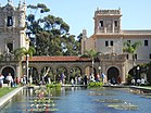
In the early part of the 20th century, San Diego hosted the World's Fair twice: the Panama-California Exposition (1915) and the California Pacific International Exposition in 1935. Both expositions were held in Balboa Park, and many of the Spanish/Baroque-style buildings that were built for those expositions remain to this day as central features of the park. The buildings were intended to be temporary structures, but most remained in continuous use until they progressively fell into disrepair. Most were eventually rebuilt, using castings of the original façades to retain the architectural style.[43] The menagerie of exotic animals featured at the 1915 exposition provided the basis for the San Diego Zoo.[44] During the 1950s there was a citywide festival called Fiesta del Pacifico highlighting the area's Spanish and Mexican past.[45] In the 2010s there was a proposal for a large-scale celebration of the 100th anniversary of Balboa Park, but the plans were abandoned when the organization tasked with putting on the celebration went out of business.[46]
The southern portion of the Point Loma peninsula was set aside for military purposes as early as 1852. Over the next several decades the Army set up a series of coastal artillery batteries and named the area Fort Rosecrans.[47] Significant U.S. Navy presence began in 1901 with the establishment of the Navy Coaling Station in Point Loma, and expanded greatly during the 1920s.[48] By 1930, the city was host to Naval Base San Diego, Naval Training Center San Diego, San Diego Naval Hospital, Camp Matthews, and Camp Kearny (now Marine Corps Air Station Miramar). The city was also an early center for aviation: as early as World War I, San Diego was proclaiming itself "The Air Capital of the West".[49] The city was home to important airplane developers and manufacturers like Ryan Airlines (later Ryan Aeronautical), founded in 1925, and Consolidated Aircraft (later Convair), founded in 1923.[50] Charles A. Lindbergh's plane The Spirit of St. Louis was built in San Diego in 1927 by Ryan Airlines.[49]
During World War II, San Diego became a major hub of military and defense activity, due to the presence of so many military installations and defense manufacturers. The city's population grew rapidly during and after World War II, more than doubling between 1930 (147,995) and 1950 (333,865).[51] During the final months of the war, the Japanese had a plan to target multiple U.S. cities for biological attack, starting with San Diego. The plan was called "Operation Cherry Blossoms at Night" and called for kamikaze planes filled with fleas infected with plague (Yersinia pestis) to crash into civilian population centers in the city, hoping to spread plague in the city and effectively kill tens of thousands of civilians. The plan was scheduled to launch on September 22, 1945, but was not carried out because Japan surrendered five weeks earlier.[52][53][54][55]
After World War II, the military continued to play a major role in the local economy, but post-Cold War cutbacks took a heavy toll on the local defense and aerospace industries. The resulting downturn led San Diego leaders to seek to diversify the city's economy by focusing on research and science, as well as tourism.[56]
From the start of the 20th century through the 1970s, the American tuna fishing fleet and tuna canning industry were based in San Diego, "the tuna capital of the world".[57] San Diego's first tuna cannery was founded in 1911, and by the mid-1930s the canneries employed more than 1,000 people. A large fishing fleet supported the canneries, mostly staffed by immigrant fishermen from Japan, and later from the Portuguese Azores and Italy whose influence is still felt in neighborhoods like Little Italy and Point Loma.[58][59] Due to rising costs and foreign competition, the last of the canneries closed in the early 1980s.[60]
Downtown San Diego was in decline in the 1960s and 1970s, but experienced some urban renewal since the early 1980s, including the opening of Horton Plaza, the revival of the Gaslamp Quarter, and the construction of the San Diego Convention Center; Petco Park opened in 2004.[61]
Geography[]

According to SDSU professor emeritus Monte Marshall, San Diego Bay is "the surface expression of a north-south-trending, nested graben". The Rose Canyon and Point Loma fault zones are part of the San Andreas Fault system. About 40 miles (64 km) east of the bay are the Laguna Mountains in the Peninsular Ranges, which are part of the backbone of the American continents.[62]
The city lies on approximately 200 deep canyons and hills separating its mesas, creating small pockets of natural open space scattered throughout the city and giving it a hilly geography.[63] Traditionally, San Diegans have built their homes and businesses on the mesas, while leaving the urban canyons relatively wild.[64] Thus, the canyons give parts of the city a segmented feel, creating gaps between otherwise proximate neighborhoods and contributing to a low-density, car-centered environment. The San Diego River runs through the middle of San Diego from east to west, creating a river valley that serves to divide the city into northern and southern segments. During the historic period and presumably earlier as well, the river has shifted its flow back and forth between San Diego Bay and Mission Bay, and its fresh water was the focus of the earliest Spanish explorers. Miguel Costansó, a cartographer, wrote in 1769, "When asked by signs where the watering-place was, the Indians pointed to a grove which could be seen at a considerable distance to the northeast, giving to understand that a river or creek flowed through it, and that they would lead our men to it if they would follow."[65][66] That river was the San Diego River.[65] Several reservoirs and Mission Trails Regional Park also lie between and separate developed areas of the city.

Notable peaks within the city limits include Cowles Mountain, the highest point in the city at 1,591 feet (485 m);[8] Black Mountain at 1,558 feet (475 m); and Mount Soledad at 824 feet (251 m). The Cuyamaca Mountains and Laguna Mountains rise to the east of the city, and beyond the mountains are desert areas. The Cleveland National Forest is a half-hour drive from downtown San Diego. Numerous farms are found in the valleys northeast and southeast of the city.
In its 2013 ParkScore ranking, The Trust for Public Land reported that San Diego had the 9th-best park system among the 50 most populous U.S. cities.[67] ParkScore ranks city park systems by a formula that analyzes acreage, access, and service and investment.
Communities and neighborhoods[]

The City of San Diego recognizes 52 individual areas as Community Planning Areas.[68] Within a given planning area there may be several distinct neighborhoods. Altogether the city contains more than 100 identified neighborhoods.
Downtown San Diego is located on San Diego Bay. Balboa Park encompasses several mesas and canyons to the northeast, surrounded by older, dense urban communities including Hillcrest and North Park. To the east and southeast lie City Heights, the College Area, and Southeast San Diego. To the north lies Mission Valley and Interstate 8. The communities north of the valley and freeway, and south of Marine Corps Air Station Miramar, include Clairemont, Kearny Mesa, Tierrasanta, and Navajo. Stretching north from Miramar are the northern suburbs of Mira Mesa, Scripps Ranch, Rancho Peñasquitos, and Rancho Bernardo. The far northeast portion of the city encompasses Lake Hodges and the San Pasqual Valley, which holds an agricultural preserve. Carmel Valley and Del Mar Heights occupy the northwest corner of the city. To their south are Torrey Pines State Reserve and the business center of the Golden Triangle. Further south are the beach and coastal communities of La Jolla, Pacific Beach, Mission Beach, and Ocean Beach. Point Loma occupies the peninsula across San Diego Bay from downtown. The communities of South San Diego (an Exclave), such as San Ysidro and Otay Mesa, are located next to the Mexico–United States border, and are physically separated from the rest of the city by the cities of National City and Chula Vista. A narrow strip of land at the bottom of San Diego Bay connects these southern neighborhoods with the rest of the city.[69]
For the most part, San Diego neighborhood boundaries tend to be understood by its residents based on geographical boundaries like canyons and street patterns.[70] The city recognized the importance of its neighborhoods when it organized its 2008 General Plan around the concept of a "City of Villages".[71]
Cityscape[]

San Diego was originally centered on the Old Town district, but by the late 1860s the focus had shifted to the bayfront, in the belief that this new location would increase trade. As the "New Town" – present-day Downtown – waterfront location quickly developed, it eclipsed Old Town as the center of San Diego.[38]
The development of skyscrapers over 300 feet (91 m) in San Diego is attributed to the construction of the El Cortez Hotel in 1927, the tallest building in the city from 1927 to 1963.[72] As time went on, multiple buildings claimed the title of San Diego's tallest skyscraper, including the Union Bank of California Building and Symphony Towers. Currently the tallest building in San Diego is One America Plaza, standing 500 feet (150 m) tall, which was completed in 1991.[73] The downtown skyline contains no super-talls, as a regulation put in place by the Federal Aviation Administration in the 1970s set a 500 feet (152 m) limit on the height of buildings within a one-mile (1.6 km) radius of the San Diego International Airport.[74] An iconic description of the skyline includes its skyscrapers being compared to the tools of a toolbox.[75]
There are several new high-rises under construction, including two that exceed 400 feet (122 m) in height.
Climate[]
| San Diego | ||||||||||||||||||||||||||||||||||||||||||||||||||||||||||||
|---|---|---|---|---|---|---|---|---|---|---|---|---|---|---|---|---|---|---|---|---|---|---|---|---|---|---|---|---|---|---|---|---|---|---|---|---|---|---|---|---|---|---|---|---|---|---|---|---|---|---|---|---|---|---|---|---|---|---|---|---|
| Climate chart (explanation) | ||||||||||||||||||||||||||||||||||||||||||||||||||||||||||||
| ||||||||||||||||||||||||||||||||||||||||||||||||||||||||||||
| ||||||||||||||||||||||||||||||||||||||||||||||||||||||||||||

San Diego has one of the top-ten best climates in the United States, according to the Farmers' Almanac[77] and has one of the two best summer climates in the country as scored by The Weather Channel.[78] Under the Köppen–Geiger climate classification system, the San Diego area has been variously categorized as having either a semi-arid climate (BSh in the original classification[79] and BSkn in modified Köppen classification with the n denoting summer fog)[80] or a Mediterranean climate[81] (Csa).[82] San Diego's climate is characterized by warm, dry summers and mild winters, with most of the annual precipitation falling between December and March. The city has a mild climate year-round,[83] with an average of 201 days above 70 °F (21 °C) and low rainfall (9–13 inches [230–330 mm] annually).
The climate in San Diego, like most of Southern California, often varies significantly over short geographical distances, resulting in microclimates. In San Diego, this is mostly because of the city's topography (the Bay, and the numerous hills, mountains, and canyons). Frequently, particularly during the "May gray/June gloom" period, a thick "marine layer" cloud cover keeps the air cool and damp within a few miles of the coast, but yields to bright cloudless sunshine approximately 5–10 miles (8–16 km) inland.[84] Sometimes the June gloom lasts into July, causing cloudy skies over most of San Diego for the entire day.[85][86] Even in the absence of June gloom, inland areas experience much more significant temperature variations than coastal areas, where the ocean serves as a moderating influence. Thus, for example, downtown San Diego averages January lows of 50 °F (10 °C) and August highs of 78 °F (26 °C). The city of El Cajon, just 10 miles (16 km) inland from downtown San Diego, averages January lows of 42 °F (6 °C) and August highs of 88 °F (31 °C).
The average surface temperature of the water at Scripps Pier in the California Current has increased by almost 3 °F (1.7 °C) since 1950, according to scientists at Scripps Institution of Oceanography.[87] Additionally, the mean minimum is now above 40 °F (4 °C), putting San Diego in hardiness zone 11, with the last freeze having occurred many decades ago.

Annual rainfall along the coast averages 10.65 inches (271 mm) and the median is 9.6 inches (240 mm).[88] The months of December through March supply most of the rain, with February the only month averaging 2 inches (51 mm) or more. The months of May through September tend to be almost completely dry. Although there are few wet days per month during the rainy period, rainfall can be heavy when it does fall. Rainfall is usually greater in the higher elevations of San Diego; some of the higher areas can receive 11–15 inches (280–380 mm) per year. Variability from year to year can be dramatic: in the wettest years of 1883/1884 and 1940/1941, more than 24 inches (610 mm) fell, whilst in the driest years there was as little as 3.2 inches (80 mm). The wettest month on record is December 1921 with 9.21 inches (234 mm).
Snow in the city is so rare that it has been observed only six times in the century-and-a-half that records have been kept. In 1949 and 1967, snow stayed on the ground for a few hours in higher locations like Point Loma and La Jolla. The other three occasions, in 1882, 1946, and 1987, involved flurries but no accumulation.[89] On February 21, 2019, snow fell and accumulated in residential areas of the city, but none fell in the downtown area.[90]
| Month | Jan | Feb | Mar | Apr | May | Jun | Jul | Aug | Sep | Oct | Nov | Dec | Year |
|---|---|---|---|---|---|---|---|---|---|---|---|---|---|
| Record high °F (°C) | 88 (31) |
90 (32) |
99 (37) |
98 (37) |
98 (37) |
101 (38) |
100 (38) |
98 (37) |
111 (44) |
107 (42) |
100 (38) |
88 (31) |
111 (44) |
| Mean maximum °F (°C) | 78.8 (26.0) |
78.6 (25.9) |
80.2 (26.8) |
82.1 (27.8) |
79.3 (26.3) |
79.6 (26.4) |
82.9 (28.3) |
85.2 (29.6) |
90.6 (32.6) |
87.8 (31.0) |
85.4 (29.7) |
77.0 (25.0) |
94.0 (34.4) |
| Average high °F (°C) | 66.4 (19.1) |
66.2 (19.0) |
67.0 (19.4) |
68.8 (20.4) |
69.5 (20.8) |
71.7 (22.1) |
75.3 (24.1) |
77.3 (25.2) |
77.2 (25.1) |
74.6 (23.7) |
70.7 (21.5) |
66.0 (18.9) |
70.9 (21.6) |
| Daily mean °F (°C) | 58.4 (14.7) |
59.0 (15.0) |
60.7 (15.9) |
62.9 (17.2) |
64.8 (18.2) |
67.2 (19.6) |
70.7 (21.5) |
72.4 (22.4) |
71.7 (22.1) |
68.1 (20.1) |
62.7 (17.1) |
57.9 (14.4) |
64.7 (18.2) |
| Average low °F (°C) | 50.3 (10.2) |
51.8 (11.0) |
54.5 (12.5) |
57.1 (13.9) |
60.0 (15.6) |
62.6 (17.0) |
66.1 (18.9) |
67.5 (19.7) |
66.2 (19.0) |
61.5 (16.4) |
54.8 (12.7) |
49.8 (9.9) |
58.5 (14.7) |
| Mean minimum °F (°C) | 43.7 (6.5) |
46.1 (7.8) |
48.7 (9.3) |
51.9 (11.1) |
55.8 (13.2) |
59.3 (15.2) |
63.0 (17.2) |
63.9 (17.7) |
61.8 (16.6) |
55.5 (13.1) |
48.2 (9.0) |
43.0 (6.1) |
42.6 (5.9) |
| Record low °F (°C) | 25 (−4) |
34 (1) |
36 (2) |
39 (4) |
45 (7) |
50 (10) |
54 (12) |
54 (12) |
50 (10) |
43 (6) |
36 (2) |
32 (0) |
25 (−4) |
| Average rainfall inches (mm) | 1.98 (50) |
2.20 (56) |
1.46 (37) |
0.65 (17) |
0.28 (7.1) |
0.05 (1.3) |
0.08 (2.0) |
0.01 (0.25) |
0.12 (3.0) |
0.50 (13) |
0.79 (20) |
1.67 (42) |
9.79 (249) |
| Average rainy days (≥ 0.01 in) | 6.5 | 7.1 | 6.2 | 3.8 | 2.2 | 0.7 | 0.7 | 0.3 | 0.9 | 2.4 | 3.7 | 5.8 | 40.3 |
| Average relative humidity (%) | 63.1 | 65.7 | 67.3 | 67.0 | 70.6 | 74.0 | 74.6 | 74.1 | 72.7 | 69.4 | 66.3 | 63.7 | 69.0 |
| Average dew point °F (°C) | 42.8 (6.0) |
45.3 (7.4) |
47.3 (8.5) |
49.5 (9.7) |
53.1 (11.7) |
57.0 (13.9) |
61.2 (16.2) |
62.4 (16.9) |
60.6 (15.9) |
55.6 (13.1) |
48.6 (9.2) |
43.2 (6.2) |
52.2 (11.2) |
| Mean monthly sunshine hours | 239.3 | 227.4 | 261.0 | 276.2 | 250.5 | 242.4 | 304.7 | 295.0 | 253.3 | 243.4 | 230.1 | 231.3 | 3,054.6 |
| Percent possible sunshine | 75 | 74 | 70 | 71 | 58 | 57 | 70 | 71 | 68 | 69 | 73 | 74 | 69 |
| Source: NOAA (sun, relative humidity, and dew point 1961–1990)[92][93][94] | |||||||||||||
Ecology[]

Like much of southern California, the majority of San Diego's current area was originally occupied on the west by coastal sage scrub and on the east by chaparral, plant communities made up mostly of drought-resistant shrubs.[95] The steep and varied topography and proximity to the ocean create a number of different habitats within the city limits, including tidal marsh and canyons. The chaparral and coastal sage scrub habitats in low elevations along the coast are prone to wildfire, and the rates of fire increased in the 20th century, due primarily to fires starting near the borders of urban and wild areas.[96]
San Diego's broad city limits encompass a number of large nature preserves, including Torrey Pines State Reserve, Los Peñasquitos Canyon Preserve, and Mission Trails Regional Park. Torrey Pines State Reserve and a coastal strip continuing to the north constitute one of only two locations where the rare species of Torrey Pine, Pinus torreyana, is found.[97]
Due to the steep topography that prevents or discourages building, along with some efforts for preservation, there are also a large number of canyons within the city limits that serve as nature preserves, including Switzer Canyon, Tecolote Canyon Natural Park,[98] and Marian Bear Memorial Park in San Clemente Canyon,[99] as well as a number of small parks and preserves.
San Diego County has one of the highest counts of animal and plant species that appear on the endangered list of counties in the United States.[100] Because of its diversity of habitat and its position on the Pacific Flyway, San Diego County has recorded 492 different bird species, more than any other region in the country.[101] San Diego always scores high in the number of bird species observed in the annual Christmas Bird Count, sponsored by the Audubon Society, and it is known as one of the "birdiest" areas in the United States.[102][103]
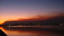
San Diego and its backcountry suffer from periodic wildfires. In October 2003, San Diego was the site of the Cedar Fire, at that time the largest wildfire in California over the past century.[104] The fire burned 280,000 acres (1,100 km2), killed 15 people, and destroyed more than 2,200 homes.[105] In addition to damage caused by the fire, smoke resulted in a significant increase in emergency room visits due to asthma, respiratory problems, eye irritation, and smoke inhalation; the poor air quality caused San Diego County schools to close for a week.[106] Wildfires four years later destroyed some areas, particularly within Rancho Bernardo, as well as the nearby communities of Rancho Santa Fe and Ramona.[100]
Demographics[]
| Historical population | |||
|---|---|---|---|
| Census | Pop. | %± | |
| 1850 | 500 | — | |
| 1860 | 731 | 46.2% | |
| 1870 | 2,300 | 214.6% | |
| 1880 | 2,637 | 14.7% | |
| 1890 | 16,159 | 512.8% | |
| 1900 | 17,700 | 9.5% | |
| 1910 | 39,578 | 123.6% | |
| 1920 | 74,361 | 87.9% | |
| 1930 | 147,995 | 99.0% | |
| 1940 | 203,341 | 37.4% | |
| 1950 | 334,387 | 64.4% | |
| 1960 | 573,224 | 71.4% | |
| 1970 | 696,769 | 21.6% | |
| 1980 | 875,538 | 25.7% | |
| 1990 | 1,110,549 | 26.8% | |
| 2000 | 1,223,400 | 10.2% | |
| 2010 | 1,307,402 | 6.9% | |
| 2020 | 1,386,932 | 6.1% | |
| Population History of Western U.S. Cities & Towns, 1850–1990[51] U.S. Decennial Census[107] 2010–2020[11] | |||
| Racial composition | 2010[108] | 1990[109] | 1970[109] | 1940[109] |
|---|---|---|---|---|
| White | 58.9% | 67.1% | 88.9% | 96.9% |
| —Non-Hispanic | 45.1% | 58.7% | 78.9%[110] | n/a |
| Black or African American | 6.7% | 9.4% | 7.6% | 2.0% |
| Hispanic or Latino (of any race) | 28.8% | 20.7% | 10.7%[110] | n/a |
| Asian | 15.9% | 11.8% | 2.2% | 1.0% |

The city had a population of 1,307,402 according to the 2010 census, distributed over a land area of 372.1 square miles (963.7 km2).[111] The urban area of San Diego extends beyond the administrative city limits and had a total population of 2,956,746, making it the third-largest urban area in the state, after that of the Los Angeles metropolitan area and San Francisco metropolitan area. They, along with the Riverside–San Bernardino, form those metropolitan areas in California larger than the San Diego metropolitan area, which had a total population of 3,095,313 at the 2010 census.
The 2010 population represents an increase of just under 7% from the 1,223,400 people, 450,691 households, and 271,315 families reported in 2000.[108] The estimated city population in 2009 was 1,306,300. The population density was 3,771.9 inhabitants per square mile (1,456.3/km2). The racial makeup of San Diego was 58.9% White, 6.7% African American, 0.6% Native American, 15.9% Asian (5.9% Filipino, 2.7% Chinese, 2.5% Vietnamese, 1.3% Indian, 1.0% Korean, 0.7% Japanese, 0.4% Laotian, 0.3% Cambodian, 0.1% Thai). 0.5% Pacific Islander (0.2% Guamanian, 0.1% Samoan, 0.1% Native Hawaiian), 12.3% from other races, and 5.1% from two or more races. The ethnic makeup of the city was 28.8% Hispanic or Latino (of any race);[108][112] 24.9% of the total population were Mexican American, 1.4% were Spanish American and 0.6% were Puerto Rican. Median age of Hispanics was 27.5 years, compared to 35.1 years overall and 41.6 years among non-Hispanic whites; Hispanics were the largest group in all ages under 18, and non-Hispanic whites constituted 63.1% of population 55 and older.

As of January 2019, the San Diego City and County had the fifth-largest homeless population among major cities in the United States, with 8,102 people experiencing homelessness.[113] In the city of San Diego, 4,887 individuals were experiencing homelessness according to the 2020 count.[114]
In 2000 there were 451,126 households, out of which 30.2% had children under the age of 18 living with them, 44.6% were married couples living together, 11.4% had a female householder with no husband present, and 39.8% were non-families. Households made up of individuals account for 28.0%, and 7.4% had someone living alone who was 65 years of age or older. The average household size was 2.61, and the average family size was 3.30.
The U.S. Census Bureau reported that in 2000, 24.0% of San Diego residents were under 18, and 10.5% were 65 and over.[108] As of 2011 the median age was 35.6; more than a quarter of residents were under age 20 and 11% were over age 65.[115] Millennials (ages 18 through 34) constitute 27.1% of San Diego's population, the second-highest percentage in a major U.S. city.[116] The San Diego County regional planning agency, SANDAG, provides tables and graphs breaking down the city population into five-year age groups.[117]
In 2000, the median income for a household in the city was $45,733, and the median income for a family was $53,060. Males had a median income of $36,984 versus $31,076 for females. The per capita income for the city was $35,199.[118] According to Forbes in 2005, San Diego was the fifth wealthiest U.S. city,[119] but about 10.6% of families and 14.6% of the population were below the poverty line, including 20.0% of those under age 18 and 7.6% of those age 65 or over.[118] San Diego was rated the fifth-best place to live in the United States in 2006 by Money magazine,[120] although it was no longer rated in the top 100 places by 2017.[121] As of January 1, 2008 estimates by the San Diego Association of Governments revealed that the household median income for San Diego rose to $66,715, up from $45,733 in 2000.[122]
San Diego was named the ninth-most LGBT-friendly city in the U.S. in 2013.[123] The city also has the seventh-highest percentage of gay residents in the U.S. Additionally in 2013, San Diego State University (SDSU), one of the city's prominent universities, was named one of the top LGBT-friendly campuses in the nation.[124]
According to a 2014 study by the Pew Research Center, 68% of the population of the city identified themselves as Christians, with 32% professing attendance at a variety of churches that could be considered Protestant, and 32% professing Roman Catholic beliefs.[125][126] while 27% claim no religious affiliation. The same study says that other religions (including Judaism, Buddhism, Islam, and Hinduism) collectively make up about 5% of the population.
Economy[]
The largest sectors of San Diego's economy are defense/military, tourism, international trade, and research/manufacturing.[127][128] In 2014, San Diego was designated by a Forbes columnist as the best city in the country to launch a small business or startup company.[129] San Diego recorded a median household income of $79,646 in 2018, an increase of 3.89% from $76,662 in 2017.[130] The median property value in San Diego in 2018 was $654,700,[130] and the average home has two cars per household.[130]
Defense and military[]


The economy of San Diego is influenced by its deepwater port, which includes the only major submarine and shipbuilding yards on the West Coast.[131] Several major national defense contractors were started and are headquartered in San Diego, including General Atomics, Cubic, and NASSCO.[132][133]
San Diego hosts the largest naval fleet in the world:[134] In 2008 it was home to 53 ships, over 120 tenant commands, and more than 35,000 sailors, marines, Department of Defense civilian employees and contractors.[135] About 5 percent of all civilian jobs in the county are military-related, and 15,000 businesses in San Diego County rely on Department of Defense contracts.[135]
Military bases in San Diego include US Navy facilities, Marine Corps bases, and Coast Guard stations. The city is "home to the majority of the U.S. Pacific Fleet's surface combatants, all of the Navy's West Coast amphibious ships and a variety of Coast Guard and Military Sealift Command vessels".[135][136]
The military infrastructure in San Diego is still growing and developing, with numerous military personnel stationed there, numbers of which are expected to rise. This plays a significant role in the city's economy, as of 2020, it provides roughly 25% of the GRP and provides 23% of the total jobs in San Diego.[137][138][139]
Tourism[]

Tourism is a major industry owing to the city's climate, beaches,[140] and tourist attractions such as Balboa Park, Belmont amusement park, San Diego Zoo, San Diego Zoo Safari Park, and SeaWorld San Diego. San Diego's Spanish and Mexican heritage is reflected in many historic sites across the city, such as Mission San Diego de Alcalá and Old Town San Diego State Historic Park. Also, the local craft brewing industry attracts an increasing number of visitors[141] for "beer tours" and the annual San Diego Beer Week in November;[142] San Diego has been called "America's Craft Beer Capital."[143]
San Diego County hosted more than 32 million visitors in 2012; collectively they spent an estimated $8 billion. The visitor industry provides employment for more than 160,000 people.[144]
San Diego's cruise ship industry used to be the second-largest in California. Numerous cruise lines operate out of San Diego. However, cruise ship business has been in decline since 2008, when the Port hosted over 250 ship calls and more than 900,000 passengers. By 2016–2017, the number of ship calls had fallen to 90.[145]
Local sightseeing cruises are offered in San Diego Bay and Mission Bay, as well as whale-watching cruises to observe the migration of gray whales, peaking in mid-January.[146] Sport fishing is another popular tourist attraction; San Diego is home to southern California's biggest sport fishing fleet.[147]
International trade[]

San Diego's commercial port and its location on the United States–Mexico border make international trade an important factor in the city's economy. The city is authorized by the United States government to operate as a Foreign Trade Zone.[148]
The city shares a 15-mile (24 km) border with Mexico that includes two border crossings. San Diego hosts the busiest international border crossing in the world, in the San Ysidro neighborhood at the San Ysidro Port of Entry.[149] A second, primarily commercial border crossing operates in the Otay Mesa area; it is the largest commercial crossing on the California-Baja California border and handles the third-highest volume of trucks and dollar value of trade among all United States-Mexico land crossings.[150]
One of the Port of San Diego's two cargo facilities is located in Downtown San Diego at the Tenth Avenue Marine Terminal. This terminal has facilities for containers, bulk cargo, and refrigerated and frozen storage, so that it can handle the import and export of many commodities.[151] In 2009 the Port of San Diego handled 1,137,054 short tons of total trade; foreign trade accounted for 956,637 short tons while domestic trade amounted to 180,417 short tons.[152]
Historically tuna fishing and canning was one of San Diego's major industries,[153] although the American tuna fishing fleet is no longer based in San Diego. Seafood company Bumble Bee Foods is headquartered in San Diego and Chicken of the Sea was until 2018.[154][155]
Companies[]

San Diego hosts several major producers of wireless cellular technology. Qualcomm was founded and is headquartered in San Diego, and is one of the largest private-sector employers in San Diego.[156] Other wireless industry manufacturers headquartered here include Nokia, LG Electronics,[157] Kyocera International,[158] Cricket Communications and Novatel Wireless.[159] The largest software company in San Diego is security software company Websense Inc.[160] San Diego also has the U.S. headquarters for the Slovakian security company ESET.[161] San Diego has been designated as an iHub Innovation Center for potential collaboration between wireless and the life sciences.[162]
The University of California, San Diego and other research institutions have helped to fuel the growth of biotechnology.[163] In 2013, San Diego had the second-largest biotech cluster in the United States, below the Boston area and above the San Francisco Bay Area.[164] There are more than 400 biotechnology companies in the area.[165] In particular, the La Jolla and nearby Sorrento Valley areas are home to offices and research facilities for numerous biotechnology companies.[166] Major biotechnology companies like Illumina and Neurocrine Biosciences are headquartered in San Diego, while many other biotech and pharmaceutical companies have offices or research facilities in San Diego. San Diego is also home to more than 140 contract research organizations (CROs) that provide contract services for pharmaceutical and biotechnology companies.[167]
Top employers[]
According to the city's 2016 Comprehensive Annual Financial Report,[168] the top employers in the city are:
| Employer | Employees |
|---|---|
| United States Navy | 38,455 |
| University of California, San Diego | 29,986 |
| Sharp HealthCare | 17,807 |
| County of San Diego | 17,384 |
| San Diego Unified School District | 14,120 |
| Qualcomm, Inc. | 11,600 |
| City of San Diego | 11,387 |
| Scripps Health | 10,853 |
| Kaiser Permanente | 8,385 |
| San Diego Community College District | 5,580 |
Real estate[]

San Diego has high real estate prices. San Diego home prices peaked in 2005, and then declined along with the national trend. As of December 2010, prices were down 36 percent from the peak,[169] median price of homes having declined by more than $200,000 between 2005 and 2010.[170] As of May 2015, the median price of a house was $520,000.[171] In November 2018 the median home price was $558,000. The San Diego metropolitan area had one of the worst housing affordability rankings of all metropolitan areas in the United States in 2009.[172]
Consequently, San Diego has experienced negative net migration since 2004. A significant number of people moved to adjacent Riverside County, commuting daily to jobs in San Diego, while others are leaving the region altogether and moving to more affordable regions.[173]
Government[]
Local government[]

The city is governed by a mayor and a nine-member city council. In 2006, its government changed from a council–manager government to a strong mayor government, as decided by a citywide vote in 2004. The mayor is in effect the chief executive officer of the city, while the council is the legislative body.[174] The City of San Diego is responsible for police, public safety, streets, water and sewer service, planning and zoning, and similar services within its borders. San Diego is a sanctuary city,[175] however, San Diego County is a participant of the Secure Communities program.[176][177] As of 2011, the city had one employee for every 137 residents, with a payroll greater than $733 million.[178]
The members of the city council are each elected from single-member districts within the city. The mayor and city attorney are elected directly by the voters of the entire city. The mayor, city attorney, and council members are elected to four-year terms, with a two-term limit.[179] Elections are held on a non-partisan basis per California state law; nevertheless, most officeholders do identify themselves as either Democrats or Republicans. In 2007, registered Democrats outnumbered Republicans by about 7 to 6 in the city,[180] and Democrats currently (as of 2021) hold a 8–1 majority in the city council. The current mayor, Todd Gloria, is a member of the Democratic Party.
San Diego is part of San Diego County, and includes all or part of the 1st, 2nd, 3rd and 4th supervisorial districts of the San Diego County Board of Supervisors,[181] Other county officers elected in part by city residents include the Sheriff, District Attorney, , and .
Areas of the city immediately adjacent to San Diego Bay ("tidelands") are administered by the Port of San Diego, a quasi-governmental agency which owns all the property in the tidelands and is responsible for its land use planning, policing, and similar functions. San Diego is a member of the regional planning agency San Diego Association of Governments (SANDAG). Public schools within the city are managed and funded by independent school districts (see below).
State and federal representation[]
In the California State Senate, San Diego County encompasses the 38th, 39th and 40th districts,[182] represented by Brian Jones (R), Toni Atkins (D), and Ben Hueso (D), respectively.
In the California State Assembly, lying partially within the city of San Diego are the 77th, 78th, 79th, and districts,[183] represented by Brian Maienschein (D), Chris Ward (D), Akilah Weber (D), and Lorena Gonzalez (D), respectively.
In the United States House of Representatives, San Diego County includes parts or all of California's 49th, 50th, 51st, 52nd, and 53rd congressional districts,[184] represented by Mike Levin (D), Darrell Issa (R), Juan Vargas (D), Scott Peters (D), and Sara Jacobs (D), respectively.
Election history[]
After narrowly supporting Lyndon B. Johnson in 1964, San Diego provided majorities to all six Republican presidential candidates from 1968 to 1988. However, in more recent decades, San Diego has trended in favor of Democratic presidential candidates for president. George H.W. Bush in 1988 is the last Republican candidate to carry San Diego in a presidential election.
| Year | Democratic | Republican | Third Parties |
|---|---|---|---|
| 2020[185] | 68.55% 461,985 | 29.14% 196,373 | 2.32% 15,614 |
| 2016[186] | 65.86% 364,108 | 28.00% 154,797 | 6.13% 33,909 |
| 2012[187] | 61.29% 312,832 | 36.43% 185,922 | 2.28% 11,660 |
| 2008[188] | 62.57% 335,724 | 35.73% 191,711 | 1.69% 9,086 |
| 2004[189] | 55.06% 270,746 | 43.91% 215,904 | 1.03% 5,071 |
| 2000[190] | 53.13% 221,979 | 42.27% 176,616 | 4.59% 19,193 |
| 1996[191] | 50.75% 198,169 | 39.93% 155,912 | 9.33% 36,414 |
| 1992[192] | 43.53% 192,829 | 31.85% 141,093 | 24.62% 109,084 |
| 1988[193] | 43.94% 177,207 | 54.67% 220,472 | 1.40% 5,631 |
| 1984[194] | 39.10% 142,985 | 59.61% 218,025 | 1.29% 4,716 |
| 1980[195] | 31.32% 106,282 | 54.96% 186,491 | 13.72% 46,569 |
| 1976[196] | 44.63% 131,525 | 53.54% 157,780 | 1.97% 5,801 |
| 1972[197] | 39.04% 114,997 | 57.93% 170,636 | 3.03% 8,916 |
| 1968[198] | 39.58% 91,276 | 54.10% 124,769 | 6.32% 14,572 |
| 1964[199] | 51.38% 112,469 | 48.62% 106,422 |
Major scandals[]
San Diego was the site of the 1912 San Diego free speech fight, in which the city restricted speech, vigilantes brutalized and tortured anarchists, and the San Diego Police Department killed a member of the Industrial Workers of the World (IWW).
In 1916, rainmaker Charles Hatfield was blamed for $4 million in damages and accused of causing San Diego's worst flood, during which about 20 Japanese American farmers died.[200]
Then-mayor Roger Hedgecock was forced to resign his post in 1985, after he was found guilty of one count of conspiracy and 12 counts of perjury, related to the alleged failure to report all campaign contributions.[201][202] After a series of appeals, the 12 perjury counts were dismissed in 1990 based on claims of juror misconduct; the remaining conspiracy count was reduced to a misdemeanor and then dismissed.[203]
A 2002 scheme to underfund pensions for city employees led to the San Diego pension scandal. This resulted in the resignation of newly re-elected Mayor Dick Murphy[204] and the criminal indictment of six pension board members.[205] Those charges were finally dismissed by a federal judge in 2010.[206]
On November 28, 2005, U.S. Congressman Randy "Duke" Cunningham resigned after being convicted on federal bribery charges. He had represented California's 50th congressional district, which includes much of the northern portion of the city of San Diego. In 2006, Cunningham was sentenced to a 100-month prison sentence.[207] He was released in 2013.
In 2005 two city council members, Ralph Inzunza and Deputy Mayor Michael Zucchet – who briefly took over as acting mayor when Murphy resigned – were convicted of extortion, wire fraud, and conspiracy to commit wire fraud for taking campaign contributions from a strip club owner and his associates, allegedly in exchange for trying to repeal the city's "no touch" laws at strip clubs.[208] Both subsequently resigned. Inzunza was sentenced to 21 months in prison.[209] In 2009, a judge acquitted Zucchet on seven out of the nine counts against him, and granted his petition for a new trial on the other two charges;[210] the remaining charges were eventually dropped.[211]
In July 2013, three former supporters of mayor Bob Filner asked him to resign because of allegations of repeated sexual harassment.[212] Over the ensuing six weeks, 18 women came forward to publicly claim that Filner had sexually harassed them,[213] and multiple individuals and groups called for him to resign. Filner agreed to resign effective August 30, 2013, subsequently pleaded guilty to one felony count of false imprisonment and two misdemeanor battery charges, and was sentenced to house arrest and probation.[214][215]
Crime[]

San Diego was ranked as the 20th-safest city in America in 2013 by Business Insider.[216] According to Forbes magazine, San Diego was the ninth-safest city in the top 10 list of safest cities in the U.S. in 2010.[217] Like most major cities, San Diego had a declining crime rate from 1990 to 2000. 1991 would mark the city's deadliest year, registering 179 homicides[218] within city limits (while the region as a whole peaked at 278 homicides),[219] capping off an unabated, eight-year climb in murders, rapes, robberies, and assault dating back to 1983. At the time, the city was ranked last among the 10 most populous U.S. cities in homicides per 1,000 population, and ninth in crimes per 1,000.[220] From 1980 to 1994, San Diego surpassed 100 murders ten times before tapering off to 91 homicides in 1995. That number would not exceed 79 for the next 15 years.[221] Crime in San Diego increased in the early 2000s.[222][223][224] In 2004, San Diego had the sixth lowest crime rate of any U.S. city with over half a million residents.[224] From 2002 to 2006, the crime rate overall dropped 0.8%, though not evenly by category. While violent crime decreased 12.4% during this period, property crime increased 1.1%. Total property crimes per 100,000 people were lower than the national average in 2008.[225]
According to Uniform Crime Report statistics compiled by the Federal Bureau of Investigation (FBI) in 2010, there were 5,616 violent crimes and 30,753 property crimes. Of these, the violent crimes consisted of forcible rapes, 73 robberies and 170 aggravated assaults, while 6,387 burglaries, 17,977 larceny-thefts, 6,389 motor vehicle thefts and 155 acts of arson defined the property offenses.[226] In 2013, San Diego had the lowest murder rate of the ten largest cities in the United States.[227]
Education[]
Primary and secondary schools[]
Public schools in San Diego are operated by independent school districts. The majority of the public schools in the city are served by the San Diego Unified School District, the second-largest school district in California, which includes 11 K–8 schools, 107 elementary schools, 24 middle schools, 13 atypical and alternative schools, 28 high schools, and 45 charter schools.[228]
Several adjacent school districts which are headquartered outside the city limits serve some schools within the city; these include the Poway Unified School District, Del Mar Union School District, San Dieguito Union High School District, and Sweetwater Union High School District. In addition, there are a number of private schools in the city.
Colleges and universities[]

According to education rankings released by the U.S. Census Bureau in 2017, 44.4% of San Diegans (city, not county) ages 25 and older hold bachelor's degrees, compared to 30.9% in the United States as a whole. The census ranks the city as the ninth-most educated city in the United States, based on these figures.[229]
The largest university in the area is the University of California, San Diego (UCSD). The university is the southernmost campus of the University of California system and is the second largest employer in the city. It is the only university in the city that is classified "R1: Doctoral Universities – Very high research activity", and it has the 7th largest research expenditure in the country.[230]
Other public colleges and universities in the city include San Diego State University (SDSU) and the San Diego Community College District, which includes San Diego City College, San Diego Mesa College, and San Diego Miramar College.
Private non-profit colleges and universities in the city include the University of San Diego (USD), Point Loma Nazarene University (PLNU), National University's San Diego campus, University of Redlands' School of Business San Diego campus, Brandman University's San Diego campus, San Diego Christian College, and John Paul the Great Catholic University. For-profit institutions include Alliant International University (AIU), California International Business University (CIBU), California College San Diego, Fashion Institute of Design & Merchandising's San Diego campus, NewSchool of Architecture and Design, Platt College, Southern States University (SSU), UEI College, and Woodbury University School of Architecture's satellite campus.
There is one medical school in the city, the UCSD School of Medicine. There are three ABA accredited law schools in the city, which include California Western School of Law, Thomas Jefferson School of Law, and University of San Diego School of Law. There is also one law school, Western Sierra Law School, not accredited by the ABA.
Libraries[]

The city-run San Diego Public Library system is headquartered downtown and has 36 branches throughout the city.[231] The newest location is in Skyline Hills, which broke ground in 2015.[232] The libraries have had reduced operating hours since 2003 due to the city's financial problems. In 2006 the city increased spending on libraries by $2.1 million.[233] A new nine-story Central Library on Park Boulevard at J Street opened on September 30, 2013.[234]
In addition to the municipal public library system, there are nearly two dozen libraries open to the public run by other governmental agencies, and by schools, colleges, and universities.[235] Noteworthy are the Malcolm A. Love Library at San Diego State University, and the Geisel Library at the University of California, San Diego.
Culture[]

Many popular museums, such as the San Diego Museum of Art, the San Diego Natural History Museum, the Museum of Us, the Museum of Photographic Arts, and the San Diego Air & Space Museum, are located in Balboa Park, which is also the location of the San Diego Zoo. The Museum of Contemporary Art San Diego (MCASD) is located in La Jolla and has a branch located at the Santa Fe Depot downtown. The downtown branch consists of two buildings on two opposite streets. The Columbia district downtown is home to historic ship exhibits belonging to the San Diego Maritime Museum, headlined by the Star of India, as well as the unrelated San Diego Aircraft Carrier Museum featuring the USS Midway aircraft carrier.
The San Diego Symphony at Symphony Towers performs on a regular basis; from 2004 to 2017, its director was Jahja Ling. The San Diego Opera at Civic Center Plaza, now directed by David Bennett, was ranked by Opera America as one of the top 10 opera companies in the United States. Old Globe Theatre at Balboa Park produces about 15 plays and musicals annually. The La Jolla Playhouse at UCSD is directed by Christopher Ashley. Both the Old Globe Theatre and the La Jolla Playhouse have produced the world premieres of plays and musicals that have gone on to win Tony Awards[236] or nominations[237] on Broadway. The Joan B. Kroc Theatre at Kroc Center's Performing Arts Center is a 600-seat state-of-the-art theatre that hosts music, dance, and theatre performances. The San Diego Repertory Theatre at the Lyceum Theatres in Westfield Horton Plaza produces a variety of plays and musicals. Hundreds of movies and a dozen TV shows have been filmed in San Diego, a tradition going back as far as 1898.[238]
Sports[]
Professional sports[]
The San Diego region is currently home to one major professional team—Major League Baseball (MLB)'s San Diego Padres, as well as several other top-level professional sports teams and minor league teams.
Baseball[]
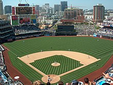
The Padres play at Petco Park in Downtown's East Village. Prior to the opening of Petco Park in 2004, the Padres had played their home games at San Diego Stadium (also known as Jack Murphy Stadium and Qualcomm Stadium) in Mission Valley since joining Major League Baseball in 1969 as an expansion team. The Padres originated as a Minor League Baseball (MiLB) team in the Pacific Coast League (PCL), where they played from 1936 through 1968 until they joined Major League Baseball. As a PCL team, the Padres were based at Lane Field (now the site of the InterContinental Hotel San Diego) in Downtown's Columbia neighborhood from 1936 through 1957, and Westgate Park in Mission Valley (now the site of Fashion Valley Mall) from 1958 through 1967. Their final season as a minor league team, 1968, was also their first at San Diego Stadium.
San Diego has hosted the MLB All-Star Game three times: 1978 and 1992 at San Diego Stadium, and 2016 at Petco Park. Additionally, Petco Park has served as one of the host sites of the World Baseball Classic three times: 2006, the inaugural tournament (for which San Diego hosted the championship), 2009, and 2017.
Football[]
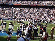
From 1961 through the 2016 season, the city hosted a National Football League (NFL) franchise, the San Diego Chargers. The Chargers, members of the American Football League (AFL) until the AFL–NFL merger in 1970, were based at Mission Valley's San Diego Stadium from 1967 through the 2016 season, and previously at Balboa Stadium in East Village–Balboa Park from 1961 through 1966. In 2017, they moved to Los Angeles following a request by owner Dean Spanos to relocate the team to SoFi Stadium, a new stadium constructed by Los Angeles Rams owner Stan Kroenke, where the Chargers would be a tenant and share the new stadium with the Rams. They are now known as the Los Angeles Chargers.[239]
The San Diego Fleet, who also played at San Diego Stadium (then known as SDCCU Stadium) competed in the single season of the short-lived Alliance of American Football (AAF).
Three NFL Super Bowl championships were held at San Diego Stadium: Super Bowl XXII in 1988, Super Bowl XXXII in 1998, and Super Bowl XXXVII in 2003.
Basketball[]
San Diego has a history in professional basketball, all encompassed within an 18-year period from 1967 to 1984.
The San Diego Rockets, a National Basketball Association (NBA) expansion franchise, played from 1967 to 1971. The franchise was founded and owned by local sports booster Robert Breitbard, who also founded and owned the original San Diego Gulls hockey franchise of the Western Hockey League and developed the San Diego Sports Arena (initially known as the San Diego International Sports Center), where the Rockets played. In 1971, the Rockets were sold and relocated to Houston after Breitbard encountered financial distress due to tax-assessment issues surrounding the sports arena, which ultimately prevented sale of the team to another local owner. The tax issues also led to Breitbard relinquishing control of the arena to Canadian millionaire Peter Graham, who's alleged mismanagement of the arena hampered future sports tenants. The franchise is now known as the Houston Rockets.
The 1971 NBA All-Star Game was held at the San Diego Sports Arena, hosted by the Rockets just months prior to the team's sale and relocation.
During the 1971–72 NBA season, San Diego was the part-time home of the Golden State Warriors for six home games (one each month of the season). The Warriors notably changed their name from "San Francisco" to "Golden State" prior to the season as the team was searching for a new home arena and looked to make a play for the San Diego market (as well as Oakland) following the departure of the Rockets to Houston. The team ultimately stayed in the San Francisco Bay Area, settling full time in Oakland at Oakland Arena the following season.
From 1972 to 1975, San Diego was home to the San Diego Conquistadors of the American Basketball Association (ABA), the league's first (and ultimately only) expansion team. Known as the Conquistadors (a.k.a. "The Q's") for its first three seasons, the name was changed to the San Diego Sails following a change in ownership for the 1975–76 season. The franchise was folded 11 games into that season after ownership learned that the team was to be shut out of the upcoming ABA–NBA merger, reportedly at the insistence of then-Los Angeles Lakers owner Jack Kent Cooke. Cooke was upset that the San Diego franchise had signed former Lakers star Wilt Chamberlain away from his franchise two years prior (Lakers ownership successfully sued Chamberlain over the contract, ultimately preventing Chamberlain from playing with the Conquistadors, relegating him to coaching duties) and also expressed unwillingness of allowing another team in Southern California.[240] The Conquistadors/Sails played at Peterson Gymnasium for the 1972–73 season and Golden Hall for the 1973–74 season before ownership was permitted to base the team at the San Diego Sports Arena, where it played the remainder of its games.
Professional basketball returned from 1978 to 1984, in the form of the NBA's San Diego Clippers, the relocated successor to the Buffalo Braves franchise. The team was based at the San Diego Sports Arena. In 1981, the Clippers were bought by Los Angeles-area real estate developer Donald Sterling. Sterling attempted to move the team the following year in 1982 to his home of Los Angeles, but his request was denied by the NBA, which investigated Sterling's alleged widespread mismanagement of the franchise the same year. The investigation report recommended the termination of Sterling's ownership of the Clippers on the basis that he had failed to pay creditors and players on time. Days before a scheduled vote to terminate his ownership, he announced he would sell the team, prompting the league to cancel the scheduled vote. Sterling ultimately remained owner, satisfying league officials by instead relinquishing operational duties of the franchise. In 1984, Sterling again applied to relocate the team to Los Angeles, and despite again being denied permission to do so from the NBA, moved the team to Los Angeles Memorial Sports Arena. Lawsuits followed, but Sterling ultimately prevailed and was able to keep the team in Los Angeles, also in part due to his close personal friendship with then-Lakers owner Jerry Buss, who welcomed sharing the Los Angeles market with Sterling's franchise.[241] The franchise is now known as the Los Angeles Clippers. San Diego has not hosted major professional basketball since.
Ice hockey[]
Though San Diego has never hosted a National Hockey League (NHL) team, the city is represented by the San Diego Gulls of the American Hockey League, the highest level of minor league ice hockey. The current version of the Gulls, which began play in 2015 after relocating from Norfolk, Virginia, plays at Pechanga Arena and following a long lineage of professional ice hockey teams which have used the San Diego Gulls name. The original San Diego Gulls, which played from 1966 until 1974, were the first tenants at the San Diego Sports Arena.
Soccer[]
San Diego has never hosted a Major League Soccer (MLS) team, though it is currently represented by San Diego Loyal SC of the USL Championship (the highest level of minor league soccer) as well as San Diego 1904 FC of the National Independent Soccer Association (the second-highest level of minor league soccer). The city also hosts the San Diego Sockers of the Major Arena Soccer League, the highest level of professional indoor soccer. The current version of the Sockers follows a lineage of other professional soccer teams which have used the San Diego Sockers name.
In 2022, the city will become the home to a a new expansion team of the National Women's Soccer League (NWSL), slated to play its home games at Torero Stadium for its inaugural season before moving to more permanent home by 2023.[242]
Lacrosse[]
The San Diego Seals of the National Lacrosse League (NLL) represent San Diego at box lacrosse's highest level. The team was founded by Joseph Tsai and began play in 2018, playing their games at Pechanga Arena.
Rugby[]
Rugby is a developing sport in the city, with top level professional teams representing San Diego in both union and league rules competition.
The San Diego Legion of Major League Rugby (MLR), the highest level of rugby union, is based in the city at Torero Stadium, having began play in 2018 as one of the league's founding franchises.
The San Diego Swell of the North American Rugby League (NARL), the highest level of rugby league, were announced in 2021 as a founding member of the league and are expected to begin play in 2022.[243]
The San Diego Breakers, who played in the only season of PRO Rugby (2016) before the league folded, likewise played at Torero Stadium. The USA Sevens, a major international rugby event, was also held at the same stadium from 2007 through 2009. San Diego is also represented by Old Mission Beach Athletic Club RFC,[244] the former home club of USA Rugby's former Captain Todd Clever.[245] San Diego participated in the Western American National Rugby League between 2011 and 2013.[246]
Other sports[]
San Diego has hosted numerous other major sports events. College football's annual bowl game, the Holiday Bowl, is held in the city. The annual Farmers Insurance Open golf tournament (formerly the Buick Invitational) on the PGA Tour occurs at Torrey Pines Golf Course. This course was also the site of the 2008 U.S. Open Golf Championship. Soccer, American football, and track and field are also played in Balboa Stadium, the city's first stadium, which was constructed in 1914.[247]
The San Diego Yacht Club hosted the America's Cup yacht races three times during the period 1988 to 1995. The amateur beach sport Over-the-line was invented in San Diego,[248] and the annual world Over-the-line championships are held at Mission Bay every year.[249]
Teams[]
Major professional team[]
| Club | Sport | Since | League | Venue (capacity) | Attendance avg. |
|---|---|---|---|---|---|
| San Diego Padres | Baseball | 1969 | Major League Baseball (MLB) | Petco Park (40,209) | 29,585 (2019) |
Other highest-level professional teams[]
| Club | Sport | Since | League | Venue (capacity) | Attendance avg. |
|---|---|---|---|---|---|
| San Diego Seals | Lacrosse (box) | 2017 | National Lacrosse League (NLL) | Pechanga Arena (12,920) | 7,769 (2018–19) |
| San Diego Sockers | Indoor Soccer | 2009 | Major Arena Soccer League (MASL) | Pechanga Arena (12,920) | 3,607 (2018–19) |
| San Diego Legion | Rugby (union) | 2018 | Major League Rugby (MLR) | Torero Stadium (8,000) | 3,043 (2019) |
| San Diego Strike Force | Indoor football | 2019 | Indoor Football League (IFL) | Pechanga Arena (12,920) | 1,734 (2018–19) |
| San Diego Aviators | Tennis | 2014 | World TeamTennis (WTT) | Omni La Costa Resort and Spa (2,100) | - |
| San Diego Growlers | Ultimate | 2015 | American Ultimate Disc League (AUDL) | Balboa Stadium (3,000) | - |
| San Diego Lions | Australian football | 1997 | United States Australian Football League
(USAFL) |
- | - |
| San Diego Swell | Rugby (league) | 2022 | North American Rugby League (NARL) | - | - |
| San Diego NWSL team | Soccer | 2022 | National Women's Soccer League (NWSL) | Torero Stadium (8,000) | - |
Minor league professional teams[]
| Club | Sport | Since | League | Venue (capacity) | Attendance avg. | Competition
Tier |
|---|---|---|---|---|---|---|
| San Diego Gulls | Ice hockey | 2015 | American Hockey League (AHL) | Pechanga Arena (12,920) | 9,021 (2018–19) | 2 |
| San Diego Loyal SC | Soccer | 2020 | USL Championship (USLC) | Torero Stadium (8,000) | 6,100 (2020) | 2 |
| San Diego 1904 FC | Soccer | 2019 | National Independent Soccer Association (NISA) | Chula Vista Elite Athlete Training Center (N/A) | 2,782 (2019) | 3 |
College teams[]
San Diego hosts three NCAA Division I universities: San Diego State University; the University of California, San Diego; and the University of San Diego. The city also hosts Point Loma Nazarene University of NCAA Division II. Also in the San Diego area are California State University, San Marcos of NCAA Division II and the University of Saint Katherine of the NAIA, both located in San Marcos, and San Diego Christian College of the NAIA, located in Santee.
| Club | University | Enrollment | League | Primary conference |
|---|---|---|---|---|
| San Diego State Aztecs | San Diego State University | 35,081 | NCAA Division I (FBS) | Mountain West Conference |
| San Diego Toreros | University of San Diego | 8,328 | NCAA Division I (FCS) | West Coast Conference |
| UC San Diego Tritons | University of California, San Diego | 40,473 | NCAA Division I | Big West Conference |
| Cal State San Marcos Cougars | California State University San Marcos | 13,893 | NCAA Division II | California Collegiate Athletic Association |
| Point Loma Nazarene Sea Lions | Point Loma Nazarene University | 3,480 | NCAA Division II | Pacific West Conference |
| San Diego Christian Hawks | San Diego Christian College | 681 | NAIA | Golden State Athletic Conference |
| Saint Katherine Firebirds | University of Saint Katherine | 300 | NAIA | California Pacific Conference |
Media[]
Published within the city are the daily newspaper, The San Diego Union Tribune and its online portal of the same name,[250] and the alternative newsweeklies, the San Diego CityBeat and San Diego Reader. Times of San Diego is a free online newspaper covering news in the metropolitan area. Voice of San Diego is a non-profit online news outlet covering government, politics, education, neighborhoods, and the arts. The San Diego Daily Transcript is a business-oriented online newspaper.
San Diego is also the headquarters of national far-right cable TV channel One America News Network (OANN), which was founded in 2013 and is owned by Herring Networks. The network gained notoriety for being ardent supporters of Donald Trump and providing a platform for right-wing conspiracy theories.
San Diego led U.S. local markets with 69.6 percent broadband penetration in 2004 according to Nielsen//NetRatings.[251]
San Diego's first television station was KFMB, which began broadcasting on May 16, 1949.[252] Since the Federal Communications Commission (FCC) licensed seven television stations in Los Angeles, two VHF channels were available for San Diego because of its relative proximity to the larger city. In 1952, however, the FCC began licensing UHF channels, making it possible for cities such as San Diego to acquire more stations. Stations based in Mexico (with ITU prefixes of XE and XH) also serve the San Diego market. Television stations today include XHTJB 3 (Once TV), XETV 6 (Canal 5), KFMB 8 (CBS, with CW/MNTV on DT2), KGTV 10 (ABC), XEWT 12 (Televisa Regional), KPBS 15 (PBS), KBNT-CD 17 (Univision), XHTIT-TDT 21 (Azteca 7), XHJK-TDT 27 (Azteca 13), XHAS 33 (Telemundo), K35DG-D 35 (UCSD-TV), KDTF-LD 51 (Unimás), KNSD 39 (NBC), KZSD-LP 20 (Azteca America), KSEX-CD 42 (Infomercials), XHBJ-TDT 45 (Gala TV), XHDTV 49 (Milenio Televisión), KUSI 51 (Independent), XHUAA-TDT 57 (Canal de las Estrellas), and KSWB-TV 69 (Fox). San Diego has an 80.6 percent cable penetration rate.[253]
Due to the ratio of U.S. and Mexican-licensed stations, San Diego is the largest media market in the United States that is legally unable to support a television station duopoly between two full-power stations under FCC regulations, which disallow duopolies in metropolitan areas with fewer than nine full-power television stations and require that there be eight unique station owners that remain once a duopoly is formed (there are only seven full-power stations on the California side of the San Diego-Tijuana market).[254] Though the E. W. Scripps Company owns KGTV and KZSD-LP, they are not considered a duopoly under the FCC's legal definition as common ownership between full-power and low-power television stations in the same market is permitted regardless to the number of stations licensed to the area. As a whole, the Mexico side of the San Diego-Tijuana market has two duopolies and one triopoly (Entravision Communications owns both XHAS-TV and XHDTV-TV, Azteca owns XHJK-TV and XHTIT-TV, and Grupo Televisa owns XHUAA-TV and XHWT-TV along with being the license holder for XETV-TV, which was formerly managed by California-based subsidiary Bay City Television).
San Diego's television market is limited to only San Diego County. The Imperial Valley, including El Centro, is in the Yuma, Arizona television market while neighboring Orange and Riverside counties are part of the Los Angeles market. (Sometimes in the past, a missing network affiliate in the Imperial Valley would be available on cable TV from San Diego.) As a result, San Diego is the largest single-county media market in the United States.
The radio stations in San Diego include nationwide broadcaster iHeartMedia; Entercom Communications, Local Media San Diego, and many other smaller stations and networks. Stations include: KOGO AM 600, KGB AM 760, KCEO AM 1000, KCBQ AM 1170, K-Praise, KLSD AM 1360, KFSD 1450 AM, KPBS-FM 89.5, Channel 933, Star 94.1, FM 94/9, FM News and Talk 95.7, Q96 96.1, KyXy 96.5, Free Radio San Diego (AKA Pirate Radio San Diego) 96.9FM FRSD, KWFN 97.3, KXSN 98.1, Big-FM 100.7, 101.5 KGB-FM, KLVJ 102.1, KSON 103.7, Rock 105.3, and another Pirate Radio station at 106.9FM, as well as a number of local Spanish-language radio stations.
Infrastructure[]
Utilities[]
Water is supplied to residents by the Water Department of the City of San Diego. The city receives most of its water from the Metropolitan Water District of Southern California.
Gas and electric utilities are provided by San Diego Gas & Electric, a division of Sempra Energy.
Street lights[]
In the mid-20th century the city had mercury vapor street lamps. In 1978, the city decided to replace them with more efficient sodium vapor lamps. This triggered an outcry from astronomers at Palomar Observatory 60 miles (100 km) north of the city, concerned that the new lamps would increase light pollution and hinder astronomical observation.[255] The city altered its lighting regulations to limit light pollution within 30 miles (50 km) of Palomar.[256]
In 2011, the city announced plans to upgrade 80% of its street lighting to new energy-efficient lights that use induction technology, a modified form of fluorescent lamp producing a broader spectrum than sodium vapor lamps. The new system is predicted to save $2.2 million per year in energy and maintenance.[257] The city stated the changes would "make our neighborhoods safer."[257] They also increase light pollution.[258]
In 2014, San Diego announced plans to become the first U.S. city to install cyber-controlled street lighting, using an "intelligent" lighting system to control 3,000 LED street lights.[259]
Transportation[]

With the automobile being the primary means of transportation for over 80 percent of residents, San Diego is served by a network of freeways and highways. This includes Interstate 5, which runs south to Tijuana and north to Los Angeles; Interstate 8, which runs east to Imperial County and the Arizona Sun Corridor; Interstate 15, which runs northeast through the Inland Empire to Las Vegas and Salt Lake City; and Interstate 805, which splits from I-5 near the Mexican border and rejoins I-5 at Sorrento Valley.
Major state highways include SR 94, which connects downtown with I-805, I-15 and East County; SR 163, which connects downtown with the northeast part of the city, intersects I-805 and merges with I-15 at Miramar; SR 52, which connects La Jolla with East County through Santee and SR 125; SR 56, which connects I-5 with I-15 through Carmel Valley and Rancho Peñasquitos; SR 75, which spans San Diego Bay as the San Diego-Coronado Bridge, and also passes through South San Diego as Palm Avenue; and SR 905, which connects I-5 and I-805 to the Otay Mesa Port of Entry.
The stretch of SR 163 that passes through Balboa Park is San Diego's oldest freeway, and has been called one of America's most beautiful parkways.[260]

San Diego's roadway system provides an extensive network of cycle routes. Its dry and mild climate makes cycling a convenient year-round option; however, the city's hilly terrain and long average trip distances make cycling less practicable. Older and denser neighborhoods around the downtown tend to be oriented to utility cycling. This is partly because of the grid street patterns now absent in newer developments farther from the urban core, where suburban style arterial roads are much more common. As a result, the majority of cycling is recreational. In 2006, San Diego was rated the best city (with a population over 1 million) for cycling in the U.S.[261]
San Diego is served by the San Diego Trolley light rail system,[262] by the SDMTS bus system,[263] and by Coaster[264] and Amtrak Pacific Surfliner[265] commuter rail; northern San Diego county is also served by the Sprinter light rail line.[266] The trolley primarily serves downtown and surrounding urban communities, Mission Valley, east county, and coastal south bay. A planned mid-coast extension of the Trolley will operate from Old Town to University City and the University of California, San Diego along the I-5 Freeway, with planned operation by 2021. The Amtrak and Coaster trains currently run along the coastline and connect San Diego with Los Angeles, Orange County, Riverside, San Bernardino, and Ventura via Metrolink and the Pacific Surfliner. There are two Amtrak stations in San Diego, in Old Town and the Santa Fe Depot downtown. San Diego transit information about public transportation and commuting is available on the Web and by dialing "511" from any phone in the area.[267]

The city has two major commercial airports within or near its city limits. Downtown San Diego International Airport (SAN), also known as Lindbergh Field, is the busiest single-runway airport in the United States.[268] It served over 24 million passengers in 2018, and is dealing with larger numbers every year.[269] It is located on San Diego Bay, three miles (4.8 km) from downtown, and maintains scheduled flights to the rest of the United States (including Hawaii), as well as to Canada, Germany, Mexico, Japan, and the United Kingdom. It is operated by an independent agency, the San Diego Regional Airport Authority. Tijuana International Airport has a terminal within the city limits in the Otay Mesa district connected to the rest of the airport in Tijuana, Mexico, via the Cross Border Xpress cross-border footbridge. It is the primary airport for flights to the rest of Mexico, and offers connections via Mexico City to the rest of Latin America. In addition, the city has two general-aviation airports, Montgomery Field (MYF) and Brown Field (SDM).[270]
Recent regional transportation projects have sought to mitigate congestion, including improvements to local freeways, expansion of San Diego Airport, and doubling the capacity of the cruise ship terminal. Freeway projects included expansion of Interstates 5 and 805 around "The Merge" where these two freeways meet, as well as expansion of Interstate 15 through North County, which includes new high-occupancy-vehicle (HOV) "managed lanes". A tollway (the southern portion of SR 125, known as the South Bay Expressway) connects SR 54 and Otay Mesa, near the Mexican border. According to an assessment in 2007, 37 percent of city streets were in acceptable condition. However, the proposed budget fell $84.6 million short of bringing streets up to an acceptable level.[271] Expansion at the port has included a second cruise terminal on Broadway Pier, opened in 2010. Airport projects include expansion of Terminal Two.[272]
Notable people[]
Sister cities[]
San Diego's sister cities are:[273]
 Alcalá de Henares, Spain (est. 1982)
 Campinas, Brazil (est. 1995)
 Cavite City, Philippines (est. 1969)
 Edinburgh, Scotland (est. 1977)
 Jalalabad, Afghanistan (est. 2004)
 Jeonju, South Korea (est. 1983)
 León, Mexico (est. 1969)
 Panama City, Panama (est. 2015)
 Perth, Australia (est. 1986)
 Taichung, Taiwan (est. 1983)
 Tema, Ghana (est. 1976)
- Tijuana, Mexico (est. 1993)
 Vladivostok, Russia (est. 1991)
 Warsaw, Poland (est. 1996)
 Yantai, China (est. 1985)
 Yokohama, Japan (est. 1957)
See also[]
This section is empty. You can help by . (October 2021) |
Notes[]
- ^ London-Gatwick and Mumbai International, which both handle slightly more traffic, each have two operational runways, though only one can be used at a time because of aircraft separation requirements (leading to these airports frequently being misleadingly referred to as "single-runway airports").
- ^ Mean monthly maxima and minima (i.e. the highest and lowest temperature readings during an entire month or year) calculated based on data at said location from 1991 to 2020.
- ^ Official precipitation records for San Diego were kept at the Weather Bureau Office in downtown from October 1850 to December 1859 at the Mission San Diego and from November 1871 to June 1939 and a variety of buildings at downtown, and at San Diego Int'l (Lindbergh Field) since July 1939.[91] Temperature records, however, only date from October 1874. For more information on data coverage, see ThreadEx
References[]
- ^ "California City Nicknames List". www.seecalifornia.com. Retrieved December 29, 2020.
- ^ "California Cities by Incorporation Date". California Association of Local Agency Formation Commissions. Archived from the original (Word) on November 3, 2014. Retrieved August 25, 2014.
- ^ "City of San Diego City Charter, Article XV" (PDF). City of San Diego. Retrieved November 5, 2014.
- ^ "Office of the City Attorney". The City of San Diego. Retrieved December 14, 2016.
- ^ "City Council Offices". City of San Diego. Retrieved December 10, 2014.
- ^ "2019 U.S. Gazetteer Files". United States Census Bureau. Retrieved July 1, 2020.
- ^ "City of San Diego". Geographic Names Information System. United States Geological Survey. Retrieved October 16, 2014.
- ^ a b "San Diego: Geography and Climate". city-data.com. Retrieved October 16, 2014.
- ^ "2020 Population and Housing State Data". United States Census Bureau. Retrieved August 22, 2021.
- ^ "ZIP code(tm) Lookup". United States Postal Service. Retrieved November 19, 2014.
- ^ a b "QuickFacts: San Diego city, California". United States Census Bureau. Retrieved August 20, 2021.
- ^ McGrew, Clarence Alan (1922). City of San Diego and San Diego County: the birthplace of California. American Historical Society. Retrieved July 23, 2011.
- ^ America: metropolitan areas. World Gazetteer. 2011. Archived from the original on September 30, 2007. Retrieved February 19, 2012.
- ^ "San Diego Int'l Airport will dig up the runway every night for a year". San Diego Union-Tribune. November 20, 2017. Retrieved January 26, 2021.
- ^ Gallegos, Dennis R. (editor). 1987. San Dieguito-La Jolla: Chronology and Controversy. San Diego County Archaeological Society, Research Paper No. 1.
- ^ Gallegos, Dennis R. 2017. First People: A Revised Chronology for San Diego County. StorySeekers, San Diego.
- ^ "Kumeyaay indians". kumeyaay.info. Retrieved July 1, 2010.[unreliable source?]
- ^ "Lesson Plan: For the Last 10,000 Years..." (PDF). National Estuarine Research Reserves via NOAA. Archived from the original (PDF) on October 18, 2011. Retrieved July 27, 2012.
- ^ a b c Mogilner, Geoffrey. "Cosoy: Birthplace of New California". San Diego History Center | San Diego, CA | Our City, Our Story. Retrieved August 27, 2020.
- ^ a b "Kosa'aay (Cosoy) History". www.cosoy.org. Retrieved August 27, 2020.
- ^ "San Diego Historical Society". Sandiegohistory.org. Retrieved March 12, 2011.
- ^ Mills, James (October 1967). "San Diego...Where California Began". Journal of San Diego History. 13 (4). Archived from the original on June 14, 2011. Retrieved February 17, 2017.
- ^ Pourade, Richard F. 1960. The History of San Diego: The Explorers. Union-Tribune Publishing Company, San Diego.
- ^ Ide, Arthur Frederick (Fall 1976). "San Diego: The Saint and the City". Journal of San Diego History. 22 (4).
- ^ "San Diego Historical Society:Timeline of San Diego history". Sandiegohistory.org. Retrieved May 4, 2011.
- ^ Carrico, Richard. "Sociopolitical Aspects of the 1775 Revolt at Mission San Diego de Alcala". San Diego History Center | San Diego, CA | Our City, Our Story. Retrieved August 27, 2020.
- ^ "Keyfacts". missionscalifornia.com. Archived from the original on June 10, 2010. Retrieved July 1, 2010.
- ^ "Mission San Diego". Mission San Diego. Retrieved July 1, 2010.
- ^ "National Park Service, National Historical Landmarks Program: San Diego Presidio". Tps.cr.nps.gov. October 10, 1960. Archived from the original on July 21, 2011. Retrieved May 4, 2011.
- ^ "Timeline of San Diego History | San Diego History Center". December 24, 2015. Archived from the original on December 24, 2015. Retrieved August 7, 2018.
- ^ Connolly, Mike. "Kumeyaay - The Mexican Period". www.kumeyaay.com.
- ^ Bean, Walton (1973). California: An Interpretive History (Second ed.). New York: McGraw-Hill, Inc. pp. 74–76. ISBN 978-0-07-004224-7.
- ^ Griswold del Castillo, Richard (Winter 2003). "The U.S.-Mexican War in San Diego, 1846–1847". San Diego Historical Society Quarterly.
- ^ Griswold de Castillo 1990, p. 39
- ^ "A History of San Diego Government". Office of the City Clerk. City of San Diego. Retrieved May 27, 2014.
- ^ "City of San Diego website". Sandiego.gov. Retrieved July 1, 2010.
- ^ Basil C. Pearce, "The Jackass Mail—San Antonio and San Diego Mail Line", San Diego Historical Society Quarterly, Spring 1969, Volume 15, Number 2
- ^ a b Engstrand 2005, p. 80
- ^ Hall, Matthew T. (February 8, 2012). "100 years ago, San Diego banned free speech". San Diego Union-Tribune. Retrieved July 9, 2021.
- ^ Dotinga, Randy (March 15, 2011). "When San Diego Had Its Own Big Labor Clash". Voice of San Diego. Retrieved July 9, 2021.
- ^ Waller, Tom (April 2, 1992). "The Wobblies and San Diego's shame | San Diego Reader". San Diego Reader. Retrieved July 9, 2021.
- ^ "Shady Ladies in the "Stingaree District" When The Red Lights Went Out in San Diego". San Diego History Center. Archived from the original on September 5, 2005. Retrieved March 8, 2011.
- ^ "Balboa Park future is full of repair jobs". The San Diego Union-Tribune. March 18, 2015. Archived from the original on March 18, 2015. Retrieved August 7, 2018.
- ^ Marjorie Betts Shaw. "The San Diego Zoological Garden: A Foundation to Build on". Journal of San Diego History. 24 (3, Summer 1978). Retrieved May 4, 2011.
- ^ "CHAPTER 5: A Fiesta – Re-living the Days of the Dons | San Diego History Center". March 4, 2016. Archived from the original on March 4, 2016. Retrieved August 7, 2018.
- ^ Perry, Tony (March 5, 2014). "Balboa Park centennial event organizers end efforts". Los Angeles Times. Retrieved April 8, 2014.
- ^ "Historic California Posts: Fort Rosecrans". California State Military Museum. Archived from the original on July 14, 2007. Retrieved November 26, 2012.
- ^ University of San Diego: Military Bases in San Diego Archived April 11, 2007, at the Wayback Machine
- ^ a b Gerald A. Shepherd. "When the Lone Eagle returned to San Diego". Journal of San Diego History. 40 (s. 1 and 2, Winter 1992). Retrieved May 4, 2011.
- ^ "Consolidated Aircraft/Convair Online Exhibition". San Diego Air & Space Museum. Retrieved September 22, 2014.
- ^ a b Moffatt, Riley. Population History of Western U.S. Cities & Towns, 1850–1990. Lanham: Scarecrow, 1996, 54.
- ^ Naomi Baumslag, Murderous Medicine: Nazi Doctors, Human Experimentation, and Typhus, 2005, p.207
- ^ "Weapons of Mass Destruction: Plague as Biological Weapons Agent". GlobalSecurity.org. Retrieved December 21, 2014.
- ^ Amy Stewart (April 25, 2011). "Where To Find The World's Most 'Wicked Bugs': Fleas". National Public Radio.
- ^ Russell Working (June 5, 2001). "The trial of Unit 731". The Japan Times.
- ^ "Milken Institute". Milken Institute. Retrieved July 1, 2010.
- ^ "San Diego History Center Honors San Diego's Tuna Fishing Industry at Annual Gala". San Diego History Center. Retrieved September 1, 2012.
- ^ Felando, August & Medina, Harold (Winter–Spring 2012). "The Origins of California's High-Seas Tuna Fleet". The Journal of San Diego History. 58 (1 & 2): 5–8, 18. ISSN 0022-4383.
- ^ Lechowitzky, Irene (November 19, 2006). "It's the old country, with new condos". Los Angeles Times. Retrieved September 1, 2012.
- ^ Crawford, Richard (June 20, 2009). "San Diego once was 'Tuna Capital of World'". San Diego Union Tribune. Retrieved September 1, 2012.[permanent dead link]
- ^ Erie, Steven P.; Kogan, Vladimir; MacKenzi, Scott A. (January 27, 2010). "Redevelopment, San Diego Style: The Limits of Public–Private Partnerships" (PDF). Urban Affairs Review. 45 (5): 644–678. doi:10.1177/1078087409359760. S2CID 154024558. Archived from the original (PDF) on February 18, 2020.CS1 maint: multiple names: authors list (link)
- ^ Marshall, Monte. "The Geology and Tectonic Setting of San Diego Bay, and That of the Peninsular Ranges and Salton Trough, Southern California". Phil Farquharson. Retrieved July 13, 2012.
- ^ "Canyon Enhancement Planning Guide" (PDF). San Diego Canyonlands. p. 7. Archived from the original (PDF) on June 20, 2013. Retrieved July 20, 2012.
- ^ Schad, Jerry (March 12, 2010). Afoot and Afield in San Diego. Wilderness Press, Berkeley, Calif. p. 111. ISBN 9780899975153. Retrieved May 4, 2011.
- ^ a b "Expeditions by Sea" The Explorers. Trans. Richard F. Pourade. La Jolla: Copley, 1960. 64–72.
- ^ Janet R. Fireman and Manuel P. Servín, "Miguel Costansó: California's Forgotten Founder." California Historical Society Quarterly, vol. 49, no. 1, March 1970, pp. 3–19.
- ^ "Report: San Diego has 9th best parks among survey of 50 U.S. cities – 10News.com KGTV ABC10 San Diego". April 27, 2014. Archived from the original on April 27, 2014. Retrieved August 7, 2018.
- ^ "City of San Diego Community Planning Areas". Sandiego.gov. Retrieved May 4, 2011.
- ^ "How San Ysidro Became Part of the City of San Diego". Voice of San Diego. May 8, 2019. Retrieved December 9, 2019.
- ^ Aitken, Stuart, and Prosser, Rudy (September 3, 2010). "Residents' Spatial Knowledge of Neighborhood Continuity and Form', Geographical Analysis". Geographical Analysis. 22 (4): 301–325. doi:10.1111/j.1538-4632.1990.tb00213.x.CS1 maint: multiple names: authors list (link)
- ^ Roger Showley (April 18, 2010). "City, SANDAG win planning awards". San Diego Union-Tribune. Retrieved May 4, 2011.
- ^ "San Diego Timeline Diagram". Skyscraper Source Media. Retrieved May 31, 2011.
- ^ "One America Plaza". Emporis.com. Retrieved May 16, 2009.
- ^ "Airport Land Use Compatibility Plan for San Diego International Airport" (PDF). San Diego County Regional Airport Authority. October 4, 2004. pp. 51–52. Archived from the original (PDF) on June 30, 2014. Retrieved May 16, 2009.
- ^ Bergman, Heather (June 27, 2005). "San Diego's skyline grows up: residential towers filling some of the missing 'tools' as office projects are nearing completion". San Diego Business Journal. The Heritage Group. Archived from the original on February 4, 2013. Retrieved August 28, 2012.
- ^ "NOAA NCEI U.S. Climate Normals Quick Access".
- ^ Geiger, Peter (October 5, 2006). "The 10 Best Weather Cities". Farmer's Almanac. Almanac Publishing. Archived from the original on June 15, 2011. Retrieved April 19, 2011.
- ^ Kellogg, Becky; Erdman, Jonathan (September 2010). "America's Best Climates". The Weather Channel. Archived from the original on July 23, 2011. Retrieved October 10, 2020.
- ^ M. Kottek; J. Grieser, C. Beck, B. Rudolf, and F. Rubel (2006). "World Map of the Köppen-Geiger climate classification updated". Meteorol. Z. 15 (3): 259–263. Bibcode:2006MetZe..15..259K. doi:10.1127/0941-2948/2006/0130. Retrieved July 9, 2013.CS1 maint: multiple names: authors list (link)
- ^ "Atlas of the Biodiversity of California" (PDF). March 31, 2010. Archived from the original (PDF) on March 31, 2010. Retrieved August 7, 2018.
- ^ Francisco Pugnaire and Fernando Valladares eds. Functional Plant Ecology. 2d ed. 2007. p.287.
- ^ Michael Allaby, Martyn Bramwell, Jamie Stokes, eds. Weather and Climate: An Illustrated Guide to Science. 2006. p.182.
- ^ Michalski, Greg et al. First Measurements and Modeling of ∆17O in atmospheric nitrate Archived July 24, 2013, at the Wayback Machine. Geophysical Research Letters, Vol. 30, No. 16. p.3. 2003.
- ^ "UCSD". Meteora.ucsd.edu. May 14, 2010. Archived from the original on June 13, 2010. Retrieved July 1, 2010.
- ^ "Monthly Averages for San Diego, CA". The Weather Channel. Archived from the original on May 2, 2009. Retrieved April 22, 2009.
- ^ "Monthly Averages for El Cajon, CA". The Weather Channel. Archived from the original on June 4, 2011. Retrieved April 22, 2009.
- ^ Lee, Mike (June 18, 2011). "Is global warming changing California Current?". U-T (San Diego Union Tribune). Retrieved June 20, 2011.
- ^ "San Diego's average rainfall set to lower level". San Diego Union-Tribune. March 16, 2011. Retrieved April 12, 2011.
- ^ Rowe, Peter (December 13, 2007). "The day it snowed in San Diego". San Diego Union Tribune. Archived from the original on August 10, 2011. Retrieved May 4, 2011.
- ^ "Storm brings major snowfall to East County communities". Fox 5. Fox 5 Digital Team. February 21, 2019. Retrieved February 27, 2021.
- ^ Conner, Glen. History of weather observations San Diego, California 1849–1948. Climate Database Modernization Program, NOAA's National Climatic Data Center. pp. 7–8.
- ^ "NowData – NOAA Online Weather Data". National Oceanic and Atmospheric Administration. Retrieved June 14, 2021.
- ^ "Summary of Monthly Normals 1991–2020". National Oceanic and Atmospheric Administration. Retrieved June 14, 2021.
- ^ "San Diego/Lindbergh Field CA Climate Normals 1961–1990". National Oceanic and Atmospheric Administration. Retrieved July 18, 2020.
- ^ Pryde, Philip R. 2014. "The Nature of the County: San Diego's Climate, Vegetation, and Wildlife". In: San Diego: An Introduction to the Region, by Philip R. Pryde, pp. 29–45. 5th ed. Sunbelt Publications, San Diego.
- ^ Wells, Michael L.; O'Leary, John F.; Franklin, Janet; Michaelsen, Joel; McKinsey, David E. (November 2, 2004). "Variations in a regional fire regime related to vegetation type in San Diego County, California (USA)". Landscape Ecology. 19 (2): 139–152. doi:10.1023/B:LAND.0000021713.81489.a7. S2CID 40769609. 1572-9761.
- ^ Strömberg, Nicklas; Hogan, Michael (November 29, 2008). "Torrey Pine: Pinus torreyana". GlobalTwitcher. Archived from the original on January 16, 2009. Retrieved April 22, 2009.
- ^ "Tecolote Canyon Natural Park & Nature Center". The City of San Diego. Retrieved April 22, 2009.
- ^ "Marian Bear Memorial Park". The City of San Diego. Retrieved April 22, 2009.
- ^ a b "SignOnSanDiego.com > News > Politics – White House seeks limits to species act". October 21, 2012. Archived from the original on October 21, 2012. Retrieved August 7, 2018.
- ^ "San Diego County Bird Atlas Project". San Diego Natural History Museum. Retrieved June 20, 2014.
- ^ "Corpus Christi Recognized as Birdiest City". Corpus Christi Daily. December 2004. Archived from the original on October 25, 2007. Retrieved April 13, 2011.
- ^ "Corpus Christi remains 'birdiest city in America'". Corpus Christi Convention and Visitors Bureau. June 25, 2008. Retrieved April 13, 2011.
- ^ Goldstein, Bruce Evan (September 2007). "The Futility of Reason: Incommensurable Differences Between Sustainability Narratives in the Aftermath of the 2003 San Diego Cedar Fire". Journal of Environmental Policy & Planning. 9 (3 & 4): 227–244. doi:10.1080/15239080701622766.
- ^ "CalFire website". Fire.ca.gov. Retrieved July 1, 2010.
- ^ Viswanathan, S.; Eria, L.; Diunugala, N.; Johnson, J.; McClean, C. (January 2006). "An Analysis of Effects of San Diego Wildfire on Ambient Air Quality". Journal of the Air & Waste Management Association. 56 (1): 56–67. doi:10.1080/10473289.2006.10464439. PMID 16499147. S2CID 27215815. Archived from the original on December 27, 2008. Retrieved December 15, 2008.
- ^ United States Census Bureau. "Census of Population and Housing". Retrieved April 27, 2015.
- ^ a b c d "San Diego (city) QuickFacts from the US Census Bureau". US Census Bureau. Archived from the original on August 2, 2012. Retrieved February 14, 2010.
- ^ a b c Gibson, Campbell; Jung, Kay. "Historical Census Statistics On Population Totals By Race, 1790 to 1990, and By Hispanic Origin, 1970 to 1990, For Large Cities And Other Urban Places In The United States". U.S. Census Bureau. Retrieved February 18, 2019.
- ^ a b From 15% sample
- ^ Census: 1,307,402 Live in San Diego (March 8, 2011). "Voice of San Diego, March 8, 2011". Voiceofsandiego.org. Archived from the original on May 12, 2011. Retrieved May 4, 2011.CS1 maint: multiple names: authors list (link)
- ^ "San Diego, CA Census Profile". USA Today. March 8, 2011. Retrieved March 12, 2011.
- ^ "2019 AHAR: Part 1 - PIT Estimates of Homelessness in the U.S. - HUD Exchange". www.hudexchange.info. United States Department of Housing and Urban Development. January 2020.
- ^ "Homelessness on City of San Diego Streets Drops by 12 Percent in Annual Count". City of San Diego Official Website. April 28, 2020.
- ^ "Population". City of San Diego. March 1, 2011. Retrieved March 2, 2016.
- ^ Lipkin, Michael (March 3, 2016). "San Diego Has Nation's Second-Largest Millennial Population". San Diego Business Journal. Retrieved March 4, 2016.
- ^ "SANDAG document". Retrieved July 1, 2010.[permanent dead link]
- ^ a b "San Diego city, California". United States Census Bureau. 2000. Archived from the original on February 12, 2020. Retrieved April 22, 2009.
- ^ Clemence, Sara (October 28, 2005). "Richest Cities in the U.S." Forbes. Retrieved April 22, 2009.
- ^ "Best Places to Live 2006". Money. 2006. Retrieved November 29, 2009.
- ^ "Best Places to Live 2017". Money. 2017. Archived from the original on September 18, 2017. Retrieved December 21, 2017.
- ^ "Population and Housing Estimates" (PDF). SANDAG: Profile Warehouse. 2008. Retrieved April 22, 2009.
- ^ Divya - NerdWallet.com (May 30, 2013). "NerdWallet names America's most gay-friendly cities | San Diego Gay and Lesbian News". Sdgln.com. Retrieved June 15, 2013.
- ^ "San Diego State University | Campus Pride | The leading national organization for LGBT student leaders and campus groups". Campus Pride. Retrieved June 15, 2013.
- ^ Major U.S. metropolitan areas differ in their religious profiles, Pew Research Center
- ^ "America's Changing Religious Landscape". Pew Research Center: Religion & Public Life. May 12, 2015.
- ^ "City of San Diego website: Economic Development". Sandiego.gov. Archived from the original on May 6, 2011. Retrieved April 11, 2011.
- ^ Powell, Ronald W. (October 17, 2007). "Tourism district OK'd by council". San Diego Union-Tribune. Retrieved April 22, 2009.
- ^ Post, Tom (March 13, 2014). "The Best Places To Launch A Startup In 2014". Forbes. Retrieved June 15, 2015.
- ^ a b c San Diego DataUSA
- ^ Ronald D. White (July 3, 2011). "Full steam ahead for Nassco shipyard in San Diego". Los Angeles Times. Retrieved September 1, 2012.
- ^ "S.D. companies dominate defense industry rankings". San Diego Union Tribune. August 11, 2010. Retrieved September 1, 2012.
- ^ "San Diego" (PDF). San Diego Convention Center Corporation. City of San Diego. Archived from the original (PDF) on May 5, 2012. Retrieved September 1, 2012.
Several major defense contractors are also headquartered in San Diego, including General Atomics, Cubic and NASSCO.
- ^ Eric Terrill; Julia Thomas, Anne Footer. "Submitted in response to Federal Funding Opportunity: FY 2011 Implementation of the U.S. Integrated Ocean Observing System (IOOS)" (PDF). Southern California Coastal Ocean Observing System. University of California, San Diego. Archived from the original (PDF) on August 26, 2011. Retrieved April 21, 2011.
- ^ Tierney Plumb (August 24, 2012). "San Diego companies lead state in '11 defense contracts". San Diego Daily Transcript. Retrieved September 1, 2012.
San Diego houses the largest concentration of military in the world; it is the homeport to more than 60 percent of the ships of the U.S. Pacific Fleet and more than one-third of the combat power of the U.S. Marine Corps.
- ^ "U.S. military economic footprint in San Diego is growing, new report says". San Diego Union-Tribune. October 10, 2019. Retrieved February 25, 2021.
- ^ "Welcome to Naval Base San Diego". Cnic.navy.mil. Retrieved February 25, 2021.
- ^ "2020 San Diego Military Economic Impact Report" (PDF). Sdmac.org. Retrieved February 25, 2021.
- ^ Calvert, Kyla (July 15, 2010). "Arizona Visitors Still Flocking To San Diego Beaches". San Diego, CA: KPBS. Retrieved May 28, 2021.
- ^ Dickerman, Sara (May 25, 2012). "Beyond San Diego's Surf and Sun: Suds". The New York Times. Retrieved May 30, 2012.
- ^ "San Diego Kicks Off First-Ever Beer Week". The Full Pint. August 17, 2009. Retrieved May 30, 2012.
- ^ Glassman, Bruce (March 30, 2014). San Diego's Top Brewers: Inside America's Craft Beer Capital. Chef's Press. ISBN 978-0981622231.
- ^ "San Diego Tourism Industry Research". San Diego Tourism Authority. 2012. Archived from the original on December 21, 2016. Retrieved July 16, 2013.
- ^ Lori Weisberg (August 10, 2017). "Is San Diego cruise business making a comeback?". San Diego Union-Tribune. Retrieved December 21, 2017.[permanent dead link]
- ^ "Whale Watching in San Diego". InTheCity-SanDiego Tourism. 2011–2012. Archived from the original on February 7, 2012. Retrieved February 19, 2012.
- ^ Sisson, Paul (September 3, 2015). "The big hook-up: Sportfishing's superb season". San Diego Union-Tribune. Retrieved September 8, 2015.
- ^ "City of San Diego:Foreign Trade Zone". Retrieved April 28, 2011.
- ^ "Number of border crossings stabilizes". San Diego Union-Tribune. July 11, 2010. Retrieved April 28, 2011.
- ^ "SANDAG: Otay Mesa Port of Entry Southbound Truck Route Improvements" (PDF). sandiegohealth.org. Retrieved April 28, 2011.
- ^ "Port of San Diego:10th Avenue Marine Terminal". Archived from the original on May 5, 2011. Retrieved April 28, 2011.
- ^ "National ranking of California ports by cargo volume". San Diego Daily Transcript. March 21, 2011. Retrieved April 28, 2011.
- ^ "Tuna! Celebrating San Diego's Famous Fishing Industry". San Diego History Center. Retrieved September 1, 2012.
- ^ Roger Showley (January 29, 2013). "Bumble Bee may buzz downtown: The tuna company considers high-profile move from Kearny Mesa". San Diego Union Tribune. Archived from the original on July 24, 2013. Retrieved February 3, 2013.
- ^ "Chicken of the Sea Moves North American HQ from S.D. to El Segundo". San Diego Business Jounral. May 3, 2018. Retrieved September 7, 2021.
- ^ "City Of San Diego Largest Employers". San Diego Daily Transcript. Retrieved April 22, 2009.
- ^ Glazer, Joyce (October 6, 2008). "San Diego-based LG Mobile Phones donated $250,000 to the VH1 Save the Music Foundation". Entrepreneur Media. Archived from the original on July 24, 2013. Retrieved March 18, 2011.[dead link]
- ^ Desjardins, Doug (January 11, 2010). "Kyocera International to Get New Leader". San Diego Business Journal. Archived from the original on July 27, 2011. Retrieved March 20, 2011.[dead link]
- ^ "Novatel website: Corporate headquarters". Archived from the original on April 17, 2011. Retrieved April 11, 2011.
- ^ "Websense Named Top Software Company in San Diego County". NBC News. November 6, 2007. Retrieved April 22, 2009.
- ^ Allen, Mike (September 20, 2010). "ESET Polishes the Apple, Now Protects Macs". San Diego Business Journal. Retrieved March 20, 2011.
- ^ "iHub San Diego" (PDF). California Governor's Office of Economic Development. Archived from the original (PDF) on July 18, 2011. Retrieved April 7, 2011.
- ^ Doyle, Monica (February 5, 2004). "UCSD Extension Awarded A $150,000 Grant For Biotechnology Collaboration With Israel". UCSD News. Retrieved April 22, 2009.
- ^ Bradley J. Fikes (February 12, 2013). "Report: San Diego 2nd in life sciences". San Diego Union Tribune. Archived from the original on July 24, 2013. Retrieved February 15, 2013.
- ^ "SDBN.org". SDBN.org. Archived from the original on July 15, 2012. Retrieved July 1, 2010.
- ^ Walcott, Susan M. (May 2002). "Analyzing an Innovative Environment: San Diego as a Bioscience Beachhead" (PDF). Economic Development Quarterly. 16 (2): 99–114. doi:10.1177/0891242402016002001. S2CID 154435216.
- ^ Bigelow, Bruce V. "San Diego's Life Sciences CROs—The Map of Clinical Research Organizations", "Xconomy", San Diego, January 27, 2010.
- ^ City of San Diego, California Comprehensive Annual Financial Report, Year ended June 30, 2016, page 325
- ^ Freeman, Mike (December 29, 2010). "Housing Prices Fall Again, Index Says". San Diego Union Tribune. Retrieved May 4, 2011.
- ^ Showley, Roger (May 9, 2010). "Realty Revival". San Diego Union Tribune. Retrieved May 4, 2011.
- ^ "Median price of home hits $520K in San Diego". FOX5 San Diego. May 8, 2015. Retrieved January 29, 2016.
- ^ Cox, Wendell (January 28, 2009). "New Survey: Improving Housing Affordability – But Still a Way to Go". NewGeography. Retrieved June 20, 2013.
- ^ Weisberg, Lori (March 22, 2007). "Greener pastures outside of county?". San Diego Union-Tribune. Archived from the original on August 14, 2016. Retrieved May 16, 2021.
- ^ "San Diego City website". Sandiego.gov. Archived from the original on July 20, 2010. Retrieved July 1, 2010.
- ^ Grant Martin (April 10, 2011). "A close look at 'sanctuary cities'". The Arizona Republic. Retrieved January 13, 2013.
These communities – called "sanctuary cities" by both critics and defenders – are home to many of the estimated 10.8 million illegal immigrants in the U.S. and include Austin, New York City, San Diego and Minneapolis.
- ^ John Coté (May 18, 2010). "Sheriff asks to opt out of federal immigration program". San Francisco Chronicle. Retrieved January 13, 2013.
The program is already in place for numerous counties in California that have sanctuary cities, including Los Angeles, San Diego and Alameda.
- ^ Ruxandra Guidi. "'Secure Communities' Program Comes Under Fire". KPBS. Retrieved January 13, 2013.
- ^ Rosiak, Luke (July 22, 2013). "EXography: 19 U.S. cities have proportionately bigger workforces than bankrupted Detroit". Washington Examiner. District of Columbia. Retrieved May 16, 2015.
- ^ "San Diego City website". Sandiego.gov. Retrieved July 1, 2010.
- ^ "Voter Registration in the City of San Diego" (PDF). San Diego Office of the City Clerk. August 1, 2007. Retrieved April 22, 2009.
- ^ "Registrar of voters: Maps of individual supervisorial districts". County of San Diego. Retrieved May 31, 2011.
- ^ "Communities of Interest – City". California Citizens Redistricting Commission. Archived from the original on October 23, 2015. Retrieved September 27, 2014.
- ^ "Communities of Interest — City". California Citizens Redistricting Commission. Archived from the original on October 23, 2015. Retrieved September 28, 2014.
- ^ "Communities of Interest – City". California Citizens Redistricting Commission. Archived from the original on September 30, 2013. Retrieved September 27, 2014.
- ^ "Supplement to the Statement of Vote. Political Districts within Counties for President" (PDF). California Secretary of State. Retrieved April 14, 2021.
- ^ "Supplement to the Statement of Vote. Political Districts within Counties for President" (PDF). California Secretary of State.
- ^ "Supplement to the Statement of Vote. Political Districts within Counties for President" (PDF). California Secretary of State.
- ^ "Political Districts within Counties for United States President" (PDF). California Secretary of State.
- ^ "Supplement to the Statement of Vote. Political Districts within Counties for President" (PDF). California Secretary of State.
- ^ "Supplement to the Statement of Vote. Political Districts within Counties for President" (PDF). California Secretary of State.
- ^ "Supplement to the Statement of Vote. Political Districts within Counties for President" (PDF). California Secretary of State.
- ^ "Supplement to the Statement of Vote. Political Districts within Counties for President" (PDF). California Secretary of State.
- ^ "Statement of vote". Sacramento, Calif. : The Secretary. November 17, 1968 – via Internet Archive.
- ^ "Statement of vote". Sacramento, Calif. : The Secretary. November 17, 1968 – via Internet Archive.
- ^ "Statement of vote". Sacramento, Calif. : The Secretary. November 17, 1968 – via Internet Archive.
- ^ "Statement of vote". Sacramento, Calif. : The Secretary. November 17, 1968 – via Internet Archive.
- ^ "Statement of vote". Sacramento, Calif. : The Secretary. November 17, 1968 – via Internet Archive.
- ^ "California statement of vote". [Sacramento, Calif.] : Secretary of State. November 17, 1962 – via Internet Archive.
- ^ "California statement of vote". [Sacramento, Calif.] : Secretary of State. November 17, 1962 – via Internet Archive.
- ^ Jenkins, Garry (2005). The Wizard of Sun City: The Strange True Story of Charles Hatfield, the Rainmaker Who Drowned a City's Dreams. Thunder's Mouth Press via Amazon Look Inside. p. Front flap. ISBN 978-1-56025-675-5.
- ^ Horstman, Barry (December 6, 1987). "Man About Town : San Diego's Ex-Mayor Roger Hedgecock Hasn't Let His Felony Conviction Get Him Down. But This Week, the Past May Catch Up With Him". Los Angeles Times. Retrieved April 2, 2011.
- ^ Abrahamson, Alan (February 2, 1992). "Bailiff's Bias in Hedgecock Trial Disclosed". Los Angeles Times. Retrieved April 3, 2011.
- ^ "Hedgecock has clean slate; judge erases felony record". San Diego Union-Tribune. January 1, 1991. Retrieved June 1, 2011.
- ^ "San Diego's Widening Pension Woes". Bloomberg BusinessWeek. June 13, 2005. Retrieved July 1, 2010.
- ^ Strumpf, Daniel (June 15, 2005) San Diego's Pension Scandal for Dummies, San Diego City Beat via Internet Archive. Retrieved April 3, 2011.
- ^ Hall, Matthew T. (April 8, 2010). "Five cleared in San Diego pension case". San Diego Union-Tribune. Retrieved July 1, 2010.
- ^ "Cunningham Moving to Arizona Prison". The Washington Post. January 5, 2007. Retrieved February 3, 2010.
- ^ Moran, Greg & Thornton, Kelly (July 19, 2005). "Councilmen Guilty". San Diego Union-Tribune. Archived from the original on August 9, 2011. Retrieved April 6, 2011.
- ^ "Ralph Inzunza Goes to Prison (Soon)". NBC San Diego. January 20, 2012. Retrieved July 8, 2012.
- ^ "Appeals Court opinion, Sept. 1, 2009" (PDF). Retrieved July 1, 2010.
- ^ Greg Moran (October 14, 2010). "Seven Years Later, Zucchet Cleared". San Diego Union-Tribune. Retrieved April 6, 2011.
- ^ Filner apologizes, gets professional help, San Diego Union Tribune, July 11, 2013
- ^ Lah, Kyung (August 21, 2013). "Another sex harassment accusation for San Diego Mayor Bob Filner". CNN. Retrieved August 22, 2013.
- ^ "San Diego Mayor Resigns in Sexual Harassment Scandal". NY Times. August 23, 2013. Retrieved August 23, 2013.
- ^ "Ex-San Diego mayor Bob Filner pleads guilty to 3 charges". USA Today. October 15, 2013. Retrieved October 15, 2013.
- ^ Safe Cities In America. Business Insider (July 25, 2013). Retrieved on September 6, 2013.
- ^ Levy, Francesca (September 11, 2010). "America's Safest Cities". Forbes. Retrieved February 20, 2011.
- ^ Landsberg, Mitchell (January 2, 1992). "Once Again, Homicide Records Fall in Many Big Cities With Graphic". Associated Press. Retrieved January 1, 2020.
- ^ Burke, Cynthia (April 2014). "Thirty Years of Crime in the San Diego Region: 1984 through 2013" (PDF). Retrieved January 1, 2020.
- ^ Platte, Mark (December 5, 1991). "Violent Crime Is Up Sharply in San Diego". Los Angeles Times. Retrieved December 25, 2020.
- ^ "San Diego Historical Crime Actuals" (PDF). 1950–2020. Retrieved December 25, 2020.
- ^ "SDPD Historical Crime Actuals 1950–2006" (PDF). San Diego Police Department. April 14, 2006. Retrieved April 22, 2009.
- ^ "SDPD Historical Crime Rates Per 1,000 Population 1950–2006" (PDF). San Diego Police Department. April 14, 2006. Retrieved April 22, 2009.
- ^ a b Manolatos, Tony; Kristina Davis (April 14, 2006). "County crows at glowing crime report". San Diego Union-Tribune. Retrieved April 22, 2009.
- ^ "Crime Report for San Diego, California". Archived from the original on June 15, 2011. Retrieved March 23, 2011.
- ^ "California – Offenses Known to Law Enforcement by State by City, 2010". Federal Bureau of Investigation. 2010. Retrieved March 7, 2013.
- ^ Davis, Kristina (February 22, 2014). "Murder hits near-record low in county". San Diego Union Tribune. Retrieved April 3, 2015.
- ^ "San Diego Unified School District – Our District". San Diego Unified School District. Archived from the original on May 14, 2011. Retrieved May 31, 2011.
- ^ "U.S. Census Bureau QuickFacts: San Diego County, California; California." Census Bureau QuickFacts. U.S. Census Bureau. Accessed March 15, 2019.
- ^ "nsf.gov - Table 20 - NCSES Higher Education Research and Development: Fiscal Year 2018 - US National Science Foundation (NSF)". ncsesdata.nsf.gov. Retrieved January 11, 2021.
- ^ "Branch Listing | City of San Diego Official Website". www.sandiego.gov. Archived from the original on September 3, 2016. Retrieved October 8, 2016.
- ^ "Construction begins on Skyline Hills Library". fox5sandiego.com. October 8, 2015. Retrieved October 8, 2016.
- ^ Hall, Matthew T. (April 12, 2006). "Budget spares libraries, parks". San Diego Union-Tribune. Retrieved April 22, 2009.
- ^ "New main library is a creation in concrete", San Diego Union-Tribune, November 16, 2011
- ^ "San Diego Area Libraries". San Diego State University. Archived from the original on November 3, 2005. Retrieved April 24, 2012.
- ^ "La Jolla Playhouse". La Jolla Playhouse. Retrieved July 1, 2010.
- ^ "Old Globe Theater". Oldglobe.org. December 2, 1937. Archived from the original on September 25, 2010. Retrieved July 1, 2010.
- ^ "Journal of San Diego History, vol. 48, no. 2". Sandiegohistory.org. Retrieved March 12, 2011.
- ^ Schrotenboer, Brent (January 12, 2017). "What we know about Chargers' move to Los Angeles". USA Today. Retrieved January 13, 2017.
- ^ "ESPN.com: Wilt battled 'loser' label". static.espn.go.com. Retrieved February 4, 2021.
- ^ Goldaper, Sam (November 13, 1983). "Clippers Are Showing Signs of Revival (Published 1983)". The New York Times. ISSN 0362-4331. Retrieved February 4, 2021.
- ^ "Women's pro soccer coming to San Diego in 2022". San Diego Union-Tribune. June 8, 2021. Retrieved June 8, 2021.
- ^ O'Brien, James (June 7, 2021). "North American Rugby League launch date pushed back". HullLive. Retrieved June 7, 2021.
- ^ "OMBAC Rugby Home". Ombac.org. Retrieved July 1, 2010.
- ^ "About". Todd Clever. January 16, 1983. Archived from the original on April 14, 2010. Retrieved July 1, 2010.
- ^ "RL Hopes to Move West". Americanrugbynews.com. Archived from the original on October 1, 2010. Retrieved March 12, 2011.
- ^ "Balboa Stadium". Stadiums of Pro Football. Retrieved September 21, 2014.
- ^ Granberry, Mike (July 10, 1981). "Over-the-Line". Los Angeles Times. Retrieved May 4, 2011.
- ^ "Over-the-Line official website". Ombac.org. Retrieved May 4, 2011.
- ^ Hello, Guest (January 3, 2012). "To our readers". UTSanDiego.com. Retrieved February 10, 2012.
- ^ "San Diego, Phoenix and Detroit Lead Broadband Wired Cities, According to Nielsen//NetRatings" (PDF). Nielsen//NetRatings. September 15, 2004. Archived from the original (PDF) on July 24, 2008. Retrieved April 25, 2011.
- ^ Stigall, Gary (May 3, 1999). "KFMB-TV Turns 50". Society of Broadcast Engineers Chapter 36 San Diego. Retrieved April 22, 2009.
- ^ San Diego market in "Market Profiles". Television Bureau of Advertising. Archived from the original on August 7, 2011. Retrieved April 25, 2011.
- ^ "FCC revives local television ownership rules". Federal Communications Commission. August 5, 1999.
- ^ Blakeslee, Sandra (August 14, 1983). "Astronomers say street lights will blind Palomar". The New York Times. Retrieved February 20, 2014.
- ^ "Outdoor lighting regulations" (PDF). City of San Diego. Retrieved February 20, 2014.
- ^ a b "San Diego to install brighter, more efficient streetlights". San Diego Gay & Lesbian News. September 19, 2011. Retrieved January 30, 2014.
- ^ City of San Diego official website, "Street Division: Electrical Street Lights" Retrieved February 15, 2014
- ^ "San Diego to Link Street Lights to Industrial Internet". Daily Fusion. Archived from the original on February 2, 2014. Retrieved January 30, 2014.
- ^ Marshall, David. San Diego's Balboa Park. Arcadia Publishing. 2007.
- ^ "San Diego, Madison (WI) and Boulder (CO) Are Best among Cities of Their Size, While Atlanta, Boston and Houston Are Worst". Bicycling. January 26, 2006. Archived from the original on January 31, 2009. Retrieved April 22, 2009.
- ^ "SDMTS – Trolley Information". San Diego Metropolitan Transit System. 2013. Retrieved July 15, 2013.
- ^ "SDMTS – Bus Routes". San Diego Metropolitan Transit System. 2013. Retrieved July 15, 2013.
- ^ "COASTER – NCTD". North County Transit District. Retrieved September 21, 2013.
- ^ "Pacific Surfliner Train – from Los Angeles to San Diego & More – Amtrak". National Railroad Passenger Corporation. 2013. Retrieved July 15, 2013.
- ^ "SPRINTER – NCTD". North County Transit District. Retrieved September 21, 2013.
- ^ "511 Overview". SANDAG. Archived from the original on July 24, 2013. Retrieved July 15, 2013.
- ^ Downey, Dave (April 24, 2006). "FAA chief says region right to consider bases". North County Times. Archived from the original on January 13, 2009. Retrieved March 8, 2021.
- ^ "San Diego International Airport: Air Traffic Reports". San Diego County Regional Airport Authority. Retrieved May 26, 2019.
- ^ "City of San Diego:Airports". Sandiego.gov. Retrieved May 4, 2011.
- ^ Hall, Matthew (May 2, 2007). "City: 37 percent of streets in acceptable driving condition". San Diego Union-Tribune. Retrieved April 22, 2009.
- ^ "San Diego International Airport – Airport Development Plan". San Diego County Regional Airport Authority. 2011. Archived from the original on July 24, 2013. Retrieved July 15, 2013.
- ^ "Our Sister Cities". San Diego International Sister Cities Association. Retrieved July 19, 2020.
General sources[]
- Engstrand, Iris Wilson (May 30, 2005). San Diego: California's Cornerstone. Sunbelt Publications, Inc. ISBN 978-0-932653-72-7. Retrieved January 14, 2015.
- Griswold de Castillo, Richard (1990). The Treaty of Guadalupe Hidalgo: A Legacy of Conflict. University of Oklahoma Press. ISBN 978-0-8061-2478-0.
External links[]
 Definitions from Wiktionary
 Media from Wikimedia Commons
 News from Wikinews
 Quotations from Wikiquote
 Texts from Wikisource
 Textbooks from Wikibooks
 Travel guides from Wikivoyage
 Resources from Wikiversity
- Official website

- Civic San Diego (replaced redevelopment corporations)
- SANDAG, San Diego's Regional Planning Agency
- Demographic Fact Sheet from Census Bureau
- San Diego Historical Society
- San Diego Unified School District
- San Diego Public Library
- San Diego Tourism Authority (formerly the San Diego Convention and Visitors Bureau)
| General |  | |
|---|---|---|
| Sites |
| |
| ||
Articles relating to San Diego and San Diego County | |||||||||||||||||||||||||||||||||||||||||||||||||||||||||||||||||||||||||||||||||||||||||||||||||||||||||||||||||||||||||||||||||||||||||||||||||||||||||
|---|---|---|---|---|---|---|---|---|---|---|---|---|---|---|---|---|---|---|---|---|---|---|---|---|---|---|---|---|---|---|---|---|---|---|---|---|---|---|---|---|---|---|---|---|---|---|---|---|---|---|---|---|---|---|---|---|---|---|---|---|---|---|---|---|---|---|---|---|---|---|---|---|---|---|---|---|---|---|---|---|---|---|---|---|---|---|---|---|---|---|---|---|---|---|---|---|---|---|---|---|---|---|---|---|---|---|---|---|---|---|---|---|---|---|---|---|---|---|---|---|---|---|---|---|---|---|---|---|---|---|---|---|---|---|---|---|---|---|---|---|---|---|---|---|---|---|---|---|---|---|---|---|---|
| |||||||||||||||||||||||||||||||||||||||||||||||||||||||||||||||||||||||||||||||||||||||||||||||||||||||||||||||||||||||||||||||||||||||||||||||||||||||||


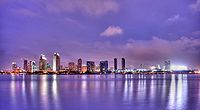


Authority control | |
|---|---|
| General | |
| National libraries | |
| Other |
|
- San Diego
- 1769 establishments in Alta California
- 1850 establishments in California
- California Enterprise Zones
- Cities in San Diego County, California
- County seats in California
- Incorporated cities and towns in California
- Populated coastal places in California
- Populated places established in 1769
- San Antonio–San Diego Mail Line
- San Diego Bay
- San Diego County, California
- San Diego metropolitan area
- Spanish mission settlements in North America
- Stagecoach stops in the United States