San Luis Obispo, California
San Luis Obispo, California | |
|---|---|
City | |
| City of San Luis Obispo | |
 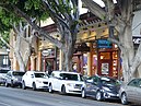  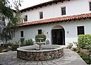  Clockwise: Mission San Luis Obispo de Tolosa, Higuera Street, Downtown San Luis, Mission San Luis Obispo de Tolosa, California Polytechnic State University. | |
 Flag  Seal | |
| Nickname(s): "SLO", "San Luis", "SLO Town" | |
 Location in San Luis Obispo County and the state of California | |
 San Luis Obispo, California Location in the United States | |
| Coordinates: 35°16′27″N 120°39′47″W / 35.27417°N 120.66306°WCoordinates: 35°16′27″N 120°39′47″W / 35.27417°N 120.66306°W | |
| Country | |
| State | |
| County | San Luis Obispo |
| Founded | September 1, 1772 |
| Incorporated | February 16, 1856[1] |
| Named for | St. Louis of Toulouse |
| Government | |
| • Type | Council-Mayor-Administrative Officer[2] |
| • Body | San Luis Obispo City Council |
| • Mayor | Heidi Harmon (D)[3] |
| • City Manager | Derek J. Johnson[4] |
| • Council Members[3] | show
List |
| • County Supervisors[5] | show
List |
| • State & Federal Congressmen[6] | show
List |
| Area | |
| • Total | 13.25 sq mi (34.32 km2) |
| • Land | 13.11 sq mi (33.94 km2) |
| • Water | 0.15 sq mi (0.38 km2) 1.18% |
| Elevation | 233 ft (71 m) |
| Population | |
| • Total | 45,119 |
| • Estimate (2019)[10] | 47,459 |
| • Density | 3,621.44/sq mi (1,398.20/km2) |
| Demonym(s) | San Luis Obispan |
| Time zone | UTC−8 (Pacific) |
| • Summer (DST) | UTC−7 (PDT) |
| ZIP Codes | 93401–93403, 93405–93410, 93412 |
| Area code | 805 |
| FIPS code | 06-68154 |
| GNIS feature IDs | 1652788, 2411796 |
| Website | slocity |


San Luis Obispo (/sæn ˌluːɪs əˈbɪspoʊ/,[11] Spanish: [san ˈlwis oˈβispo]) is a city in the U.S. state of California and San Luis Obispo County, 190 miles (310 km) north of Los Angeles and 230 miles (370 km) south of San Francisco on Southern California's Central Coast. The population was 45,119 at the 2010 census.[12]
Founded in 1772 by Spanish Franciscan Junípero Serra, San Luis Obispo is one of California's oldest European-founded communities. Serra's Mission San Luis Obispo de Tolosa was named after the 13th-century saint and bishop Louis of Toulouse. The city, locally referred to as San Luis or SLO, is the county seat of San Luis Obispo County and is adjacent to California Polytechnic State University.
History[]
Native American[]
The earliest human inhabitants of the local area were the Chumash people. One of the earliest villages lies south of San Luis Obispo and reflects the landscape of the early Holocene when estuaries came farther inland. The Chumash people used marine resources of the inlets and bays along the Central Coast and inhabited a network of villages, including sites at Los Osos and Morro Creek.[13] The tribal site on present-day San Luis Obispo was named tiłhini, Obispeño for "Place of the full moon".[14]
Mission period[]
During the Spanish Empire expansion throughout the world, specifically in 1769, Franciscan Junípero Serra received orders from Spain to bring the Catholic faith to the natives of Alta California; the idea was to unify the empire under the same religion and language. Mission San Diego was the first Spanish mission founded in Alta California that same year.
On September 7, 1769, an expedition led by Gaspar de Portolá entered the San Luis Obispo area from coastal areas around today's Pismo Beach. One of the expedition's three diarists, padre Juan Crespí, recorded the name given to this area by the soldiers as Cañada de Los Osos ("cañada" translates as "valley" or "canyon"). The party traveled north along San Luis Obispo Creek, turned west through Los Osos Valley, and reached Morro Bay on September 9.[15]
In 1770, Portola established the Presidio of Monterey and Junípero Serra founded the second mission, San Carlos Borromeo, in Monterey. The mission was moved to Carmel the following year. As supplies dwindled in 1772 at the mission and Presidio, the people faced starvation. Remembering the Valley of the Bears, Presidio of Monterey commander Pedro Fages (a member of the Portolà expedition) led a hunting expedition to bring back food. Over twenty-five mule loads of dried bear meat and seed were sent north to relieve the missionaries, soldiers, and neophytes (baptized natives). The natives were impressed at the ease by which the Spaniards could take down the huge grizzlies with their weapons. Some of the bear meat was traded with the local people in exchange for edible seed. It was after this that Junípero Serra decided that La Cañada de Los Osos would be an ideal place for the fifth mission.[citation needed]
The area had abundant supplies of food and water, the climate was also very mild, and the local Chumash were very friendly. With soldiers, muleteers, and pack animals carrying mission supplies, Junípero Serra set out from Carmel to reach the Valley of the Bears. On September 1, 1772, Junípero Serra celebrated the first Mass with a cross erected near San Luis Creek. The very next day, he departed for San Diego leaving Fr. José Cavaller, with the difficult task of building the mission. Fr. , five soldiers and two neophytes began building Mission San Luis Obispo de Tolosa (Spanish for '"St. Louis Bishop of Toulouse"') which would later become the town of San Luis Obispo.
The first mission structures were built with whatever materials could be found nearby. Later, more permanent buildings were constructed with adobe walls, wood timber roof beams and tile roofs. The completed mission compound included: the church, the priests' residence, the convento, storerooms, neophyte and visitor residences, soldiers' barracks and other structures. The mission also had a grist mill, tannery, water supply system, land for farming and pastures for livestock. The whole community of priests, natives and soldiers needed to produce goods for their own livelihood.
When the Mexican War of Independence from Spain broke out in 1810, all California missions had to become virtually self-sufficient, receiving few funds or supplies from Spanish sources. Beginning soon after Mexico won her independence from Spain in 1821, anti-Spanish feelings led to calls for expulsion of the Spanish Franciscans and secularization of the missions. Because the fledgling Mexican government had many more important problems to deal with than far-off California, actual secularization didn't happen until the mid-1830s.
Rancho and town[]

After 1834, the mission became an ordinary parish, and most of its huge land holdings were broken up into land grants called ranchos. The ranchos were given by Mexican land grant from 1837 to 1846, with the mission itself being granted in the final year. The central community, however, remained in the same location and formed the nucleus of today's city of San Luis Obispo.
After the Mexican–American War annexed California to the United States, San Luis Obispo was the first town incorporated in the newly formed San Luis Obispo County. It remained the center of the county to the present. Early in the American period, the region was well known for lawlessness.[16] It gained a reputation as "Barrio del Tigre" (or Tiger-Town) because of the endemic problem.[17] Robberies and murders that left no witnesses were carried out on along the El Camino Real and elsewhere around San Luis Obispo for several years. Finally a gang of eight men committed a robbery with three murders and a kidnapping at the Rancho San Juan Capistrano del Camote in May 1858, that uncharacteristically left two witnesses alive. This brought about the formation of a vigilance committee in the County that killed one, the suspected leader of the gang , and lynched six others, a total of seven men suspected of such misdeeds (the most lethal in California history).[16][17][18] Members of the committee remained influential members of the community for decades.
The ranchos remained focused on cattle after the conquest of California. With the discovery of gold, the county experienced a major economic surge with the rising price of beef, with the highest prices coming in 1851. The county remained focused on cattle until 1863, when a drought left most ranchos devastated. Residents quickly turned to other venues, leading to the breaking up of many of the ranchos and a major change in the economic climate of the town, which focused less on cattle ranching and more on dairies, agriculture, and mined goods from then onward.
San Luis Obispo once had a burgeoning Chinatown in the vicinity of Palm St. and Chorro Street. Laborers were brought from China by Ah Louis in order to construct the Pacific Coast Railway, roads connecting San Luis Obispo to Paso Robles and Paso Robles to Cambria, and also the 1884 to 1894 tunneling through Cuesta Ridge for the Southern Pacific Railroad. The town's Chinatown revolved around Ah Louis Store and other Palm Street businesses owned and run by Chinese business people. Today, Mee Heng Low chop suey shop is all that remains of the culture, although a slightly Chinatown-themed commercial development has been planned. A display of some of the unearthed relics from this period can be seen on the first floor of the Palm Street parking garage, which was built over the location where Chinatown once stood. The San Luis Obispo Historical Society (adjacent to the Mission) also contains rotating historical exhibits.[19]
San Luis Obispo was also a popular stop when people are on the way to Los Angeles. U.S. Route 101 and California State Route 1 with the rise of car culture. Due to its popularity as a stop, it was the location of the first motel in the world, the Milestone Mo-Tel.
San Luis Obispo's largest and oldest voluntary organization is the San Luis Obispo Chamber of Commerce, which also is the oldest and largest voluntary organization in San Luis Obispo County.
Historic buildings and districts[]
San Luis Obispo has more than 180 historic buildings that have been designated as City of San Luis Obispo Historic Resources. Three of the city's designated historic resources have also been designated as California Historic Landmarks. They are: Mission San Luis Obispo de Tolosa (CHL 325); Dallidet Adobe (CHL 720); and Ah Louis Store (CHL 802). In addition, eight of the city's designated historic resources have been listed on the National Register of Historic Places (NRHP). They are: Myron Angel House (NRHP 11/22/82); Pacific Coast Railway Company Grain Warehouse (NRHP 6/23/88); Robert Jack House (NRHP 4/13/92); Tribune-Republic Building (NRHP 6/24/93); San Luis Obispo Carnegie Library (NRHP 3/30/95); Ah Louis Store (NRHP 3/26/08); William Shipsey House (NRHP 3/31/10); and (NRHP 5/10/16). The Carnegie Library, located at 696 Monterey Street, is home to the San Luis Obispo County Historical Museum which includes a research center with information on the city's other historical resources.[20]
The city also has five designated historic districts as follows:
- Downtown Historic District – Covers 61.5 acres generally bounded by Palm Street to the north, Marsh Street to the south, Osos Street to the east, and Nipomo Street to the west, plus Dana Street in the northwest. The Downtown Historic District covers the oldest part of the city, including the Mission San Luis Obispo de Tolosa and many commercial structures from the city's boom era from the 1890s to the 1910s.[21]
- Chinatown Historic District – Covers 4.4 acres along both sides of Palm Street between Chorro and Morrow Streets. Established in 1995 to recognize the contributions of the city's Chinese community.[22]
- Old Town Historic District – Covers 86 acres generally bounded by Pacific Street on the north, Islay Street on the south, Santa Rosa Street on the east, and Beach Street on the west. Established in 1987, the district is located in the city's oldest residential neighborhoods with historic homes dating from the 1880s to the turn of the century.[23]
- Mill Street Historic District – Covers 20 acres from Peach Street on the north, Palm Street on the south, Pepper Street on the east and Toro Street on the west Established in 1987, the area consists of early 20th century homes in the Tudor Revival, Craftsman, Mission Revival, Prairie Colonial, and Shingle styles. Sometimes referred to as Fremont Heights.[24]
- Railroad Historic District – Covers 80.7 acres bounded by the railroad right-of-way on the east, Johnson Avenue on the north, Orcutt Road on the south, Leff Street on the northwest, and Broad Street on the west. Established in 1998 along the historic boundaries of the Southern Pacific rail yard. It includes residential and commercial resources constructed following the arrival of the Southern Pacific Railroad in 1894.[25]
Geography[]
San Luis Obispo is located on U.S. Route 101 about 31 miles (50 km) north of Santa Maria.
According to the United States Census Bureau, the city has a total area of 12.93 square miles (33.5 km2), of which, 12.78 square miles (33.1 km2) is land and 0.15 square miles (0.39 km2) (1.18%) is water.
San Luis Obispo is on the West Coast of the United States and in the Central Coast of California. The Pacific Ocean is about 11 miles (18 km) west of San Luis Obispo. The Santa Lucia Mountains lie just east of San Luis Obispo. These mountains are the headwaters for San Luis Obispo Creek, whose watershed encompasses 84 square miles (220 km2) surrounding the city and flows to the Pacific Ocean at Avila Beach.[26]
San Luis Obispo is a seismically active area; there are a number of nearby faults including the San Andreas Fault. The Nine Sisters are a string of hills that partially run through San Luis Obispo. They are geologically noteworthy for being volcanic plugs. Six of the nine peaks are open to the public for recreation.[27]

Climate[]
San Luis Obispo experiences a cool Mediterranean climate (Köppen climate classification Csb). On average it has 50 days with measurable rain per year – mostly during winter months. Summers are generally warm and sunny, often with morning fog from the Pacific coast. Winters are generally mild, though below freezing lows may be expected four nights per year.[citation needed] Measurable snowfall in San Luis Obispo has not officially been recorded since records began in 1870, although photos show about 0.3 inches (0.76 cm) fell in 1922 and snow flurries were reported in both 1988 and 2006. Temperatures do, however, vary widely at any time of the year, with 80 °F (27 °C) readings in January and February not uncommon. On January 15, 2021, the weather station at California Polytechnic University (San Luis Obispo) recorded a temperature of 93 degrees Fahrenheit, being the warmest "winter" temperature ever recorded in the city. Although heat extremes in the 110s have been recorded, the maritime moderation is generally strong due to the proximity to the cool ocean waters.
| hideClimate data for San Luis Obispo (1981–2010 normals, extremes 1927–present) | |||||||||||||
|---|---|---|---|---|---|---|---|---|---|---|---|---|---|
| Month | Jan | Feb | Mar | Apr | May | Jun | Jul | Aug | Sep | Oct | Nov | Dec | Year |
| Record high °F (°C) | 93 (34) |
89 (32) |
92 (33) |
104 (40) |
102 (39) |
109 (43) |
111 (44) |
107 (42) |
114 (46) |
109 (43) |
98 (37) |
92 (33) |
114 (46) |
| Average high °F (°C) | 61.1 (16.2) |
62.0 (16.7) |
63.6 (17.6) |
66.4 (19.1) |
69.3 (20.7) |
73.0 (22.8) |
76.0 (24.4) |
76.9 (24.9) |
76.8 (24.9) |
73.7 (23.2) |
67.3 (19.6) |
61.1 (16.2) |
69.0 (20.6) |
| Daily mean °F (°C) | 52.3 (11.3) |
53.4 (11.9) |
54.7 (12.6) |
56.7 (13.7) |
59.3 (15.2) |
62.6 (17.0) |
65.2 (18.4) |
65.9 (18.8) |
65.5 (18.6) |
62.6 (17.0) |
57.2 (14.0) |
52.1 (11.2) |
59.0 (15.0) |
| Average low °F (°C) | 43.6 (6.4) |
44.8 (7.1) |
45.8 (7.7) |
47.0 (8.3) |
49.2 (9.6) |
52.1 (11.2) |
54.5 (12.5) |
54.8 (12.7) |
54.3 (12.4) |
51.5 (10.8) |
47.1 (8.4) |
43.1 (6.2) |
49.0 (9.4) |
| Record low °F (°C) | 24 (−4) |
21 (−6) |
28 (−2) |
29 (−2) |
32 (0) |
35 (2) |
36 (2) |
40 (4) |
35 (2) |
30 (−1) |
23 (−5) |
17 (−8) |
17 (−8) |
| Average precipitation inches (mm) | 4.95 (126) |
5.12 (130) |
3.97 (101) |
1.39 (35) |
0.47 (12) |
0.10 (2.5) |
0.02 (0.51) |
0.04 (1.0) |
0.26 (6.6) |
0.93 (24) |
2.16 (55) |
3.71 (94) |
23.12 (587) |
| Average precipitation days (≥ 0.01 in) | 8.8 | 9.7 | 9.1 | 4.4 | 2.2 | 0.6 | 0.4 | 0.3 | 1.2 | 3.0 | 4.9 | 7.7 | 52.3 |
| Source: NOAA[28][29] | |||||||||||||
Demographics[]
| Historical population | |||
|---|---|---|---|
| Census | Pop. | %± | |
| 1880 | 2,243 | — | |
| 1890 | 2,995 | 33.5% | |
| 1900 | 3,021 | 0.9% | |
| 1910 | 5,157 | 70.7% | |
| 1920 | 5,895 | 14.3% | |
| 1930 | 8,276 | 40.4% | |
| 1940 | 8,881 | 7.3% | |
| 1950 | 14,180 | 59.7% | |
| 1960 | 20,437 | 44.1% | |
| 1970 | 28,036 | 37.2% | |
| 1980 | 34,252 | 22.2% | |
| 1990 | 41,958 | 22.5% | |
| 2000 | 44,174 | 5.3% | |
| 2010 | 45,119 | 2.1% | |
| 2019 (est.) | 47,459 | [10] | 5.2% |
| U.S. Decennial Census[30] | |||

2010[]
The 2010 United States Census[12] reported that San Luis Obispo had a population of 45,119. The population density was 3,489.4 people per square mile (1,347.3/km2). The racial makeup of San Luis Obispo was 38,117 (84.5%) White, 523 (1.2%) African American, 275 (0.6%) Native American, 2,350 (5.2%) Asian, 65 (0.1%) Pacific Islander, 1,973 (4.4%) from other races, and 1,816 (4.0%) from two or more races. Hispanic or Latino people of any race were 6,626 persons (14.7%).
The Census reported that 43,937 people (97.4% of the population) lived in households, 967 (2.1%) lived in non-institutionalized group quarters, and 215 (0.5%) were institutionalized.
There were 19,193 households, out of which 3,178 (16.6%) had children under the age of 18 living in them, 5,690 (29.6%) were opposite-sex married couples living together, 1,336 (7.0%) had a female householder with no husband present, 586 (3.1%) had a male householder with no wife present. There were 1,104 (5.8%) unmarried opposite-sex partnerships, and 124 (0.6%) same-sex married couples or partnerships. 6,213 households (32.4%) were made up of individuals, and 1,957 (10.2%) had someone living alone who was 65 years of age or older. The average household size was 2.29. There were 7,612 families (39.7% of all households); the average family size was 2.81.
The population was spread out, with 5,522 people (12.2%) under the age of 18, 15,670 people (34.7%) aged 18 to 24, 9,630 people (21.3%) aged 25 to 44, 8,866 people (19.7%) aged 45 to 64, and 5,431 people (12.0%) who were 65 years of age or older. The median age was 26.5 years. For every 100 females, there were 109.1 males. For every 100 females age 18 and over, there were 110.2 males.
There were 20,553 housing units at an average density of 1,589.5 per square mile (613.7/km2), of which 7,547 (39.3%) were owner-occupied, and 11,646 (60.7%) were occupied by renters. The homeowner vacancy rate was 1.6%; the rental vacancy rate was 5.7%. 17,225 people (38.2% of the population) lived in owner-occupied housing units and 26,712 people (59.2%) lived in rental housing units.
The city has a desired maximum population of 57,200 within the urban reserve, however with the extremely rapid growth of the area it is unknown whether this population cap will remain.[31]
2000[]
As of the 2000 census,[32] there were 27, 819 people, 18,639 households, and 7,697 families residing in the city. The population density was 4,144.5 people per square mile (1,600.0/km2). There were 19,306 housing units at an average density of 1,811.3 per square mile (699.3/km2). The racial makeup of the city was 84.1% White, 5.3% Asian, 1.5% African American, 0.7% Native American, 0.1% Pacific Islander, 4.8% from other races, and 3.6% from two or more races. 11.7% of the population were Hispanic or Latino of any race.
There were 18,639 households, out of which 17.7% had children under the age of 18 living with them. 31.3% were married couples living together, 7.2% had a female householder with no husband present, and 58.7% were non-families. 32.7% of all households were made up of individuals, and 9.5% had someone living alone who was 65 years of age or older. The average household size was 2.27 and the average family size was 2.86.
In the city, the population was spread out, with 14.2% under the age of 18, 33.6% from 18 to 24, 23.7% from 25 to 44, 16.5% from 45 to 64, and 12.1% who were 65 years of age or older. The median age was 26 years. For every 100 females, there were 105.8 males. For every 100 females age 18 and over, there were 106.3 males.
The median income for a household in the city was $98,977 and the median income for a family was $112,740. The median household income in San Luis Obispo County was $60,534, and the median family income was $72,327. Males had a median income of $41,915 versus $27,407 for females. The per capita income for the city was $20,386. 26.6% of the population and 7.1% of families were below the poverty line, a similar number to Cleveland, Ohio. Out of the total population, 9.3% of those under the age of 18 and 4.6% of those 65 and older were living below the poverty line.
Economy[]
Downtown San Luis Obispo is centered around the Mission San Luis Obispo de Tolosa. The downtown area has many eclectic shops and boutiques.[33] One of the primary draws of this area for students, visitors, and residents are outdoor sports such as hiking, kayaking, surfing, windsurfing, skimboarding, diving, sailing, and kite boarding. Takken's Shoes is headquartered in San Luis Obispo. Ernie Ball's Music Man factory is located in San Luis Obispo. Mindbody and iFixit have been headquartered in San Luis Obispo since their inceptions. In 2019, SLO experienced a boom in home construction along with continued building of commercial structures. As housing had not kept up with job growth, many people who cannot afford to live where they work, commute to their jobs in SLO.[34]
Pacific Gas and Electric is the largest non-governmental employer in the city.[35] In 2016, they announced the closure of the Diablo Canyon Nuclear Power Plant in 2025, which will cost the local economy 1500 jobs with an average salary of $157,000, as well as nearly $1 billion annually in economic activity. An impact mitigation of $85 million was denied by the California Public Utilities Commission, leaving the community short on funds for schools and other projects.[36] It is expected that there will be cuts to schools, public services, and a regional economic depression. San Luis Coast Unified School District is projected to lose at least 9% of their current annual operating income. Measures to weather the economic downturn are being investigated by the city.[37] One such bill, SB1090, was introduced by state senators Bill Monning and Jordan Cunningham on March 16, 2018, in an attempt to reclaim the $85 million that was denied by the CPUC, as well as to secure $350 million towards keeping workers at the plant and in the city until the final shutdown in 2025.[38] Congressman Salud Carbajal introduced H.R. 5441 to the House of Representatives in order to create Energy Opportunity Zones, which is designed to specifically target areas that have had a nuclear power plant shut down within 10 years (including San Luis Obispo) for federal tax credits for renewable energy generation, including solar, wind, and wave energy.[39]
Top employers[]
According to the city's 2009 Comprehensive Annual Financial Report,[40] the top employers in the city are:
| # | Employer | Employees |
|---|---|---|
| 1 | California Polytechnic State University | 2,693 |
| 2 | County of San Luis Obispo | 2,570 |
| 3 | California Men's Colony | 2,000 |
| 4 | Pacific Gas and Electric (Diablo Canyon) | 1,719 |
| 5 | Cal Poly Corporation | 1,641 |
| 6 | Cuesta College | 1,559 |
| 7 | Tenet Healthcare | 1,100 |
| 8 | San Luis Coastal Unified School District | 873 |
| 9 | City of San Luis Obispo | 583 |
| 10 | Community Action Partnership of San Luis Obispo County | 403 |
Government[]
Local[]
San Luis Obispo is incorporated as a charter city. It is also the county seat of San Luis Obispo County. The city charter provides for a "Council-Mayor-City Manager" form of municipal government.[41] The City Council has five members, a mayor who is elected to two-year terms, with each mayor limited to serving no more than four consecutive terms, and four city council members who are elected to four-year terms, with each council member limited to serving no more than two consecutive terms.[42]
Fire department[]
The fire department of San Luis Obispo was first organized in 1872 and now has 45 full-time firefighters and four fire stations (as of 2007).[43] The SLO City Fire Stations are staffed with three-man ALS engine companies and a four-man ALS Truck company. Each apparatus has at least one paramedic on duty each day. The department responds to over 4,500 calls each year. The San Luis Obispo City Fire Department also maintains a bike medic program which is used at the Farmers' Market and other special events throughout the city. Four members of the Fire Department are also on the San Luis Obispo SWAT Team as SWAT Medics and respond using Squad 1 (an ALS equipped ambulance which also carries some light rescue gear and other specialty tools) The front-line members of the department are represented by the San Luis Obispo City Firefighters' IAFF Local 3523.[43]
Utilities Department[]
The City of San Luis Obispo Utilities Department can trace its lineage back to 1872 when plans were made to provide the city with safe drinking water.[44] Currently the Utilities Department operates a water treatment plant designed to treat 16 million gallons a day, the Whale Rock Reservoir located in Cayucos, CA, a water distribution system including 15 pressure zones and 150 miles of water mains.[45] The Water Resource Recovery Facility treats 4.5 million gallons per day and is currently undergoing a plant upgrade expected to be completed in 2021.[46]
Notable ordinances[]
In June 1990 City Councilman proposed a city ordinance to ban smoking in all indoor public areas. Following a failed effort[citation needed] by R. J. Reynolds Tobacco Company to defeat the ordinance, the City Council voted 4–1 in favor on June 19, 1990, with only Mayor Ron Dunin dissenting. As a result, on August 2, 1990, San Luis Obispo became the first municipality in the world to ban smoking in all public buildings, including bars and restaurants. This statute has been a catalyst worldwide in anti-smoking legislation.[47][48][49] In April, 2010, San Luis Obispo strengthened its anti-smoking legislation, making smoking in public, excepting for certain conditions, a citable offense beginning on June 20, 2010.[50]
In 1982, following public hearings, the City Council approved an ordinance forbidding the construction of "drive-through" businesses.[51] In-N-Out Burger opened a restaurant in the nearby town of Atascadero because of the ban.[52] In 2008 the City Council voted 3–2 to keep the ban.[53][54]
In 1982 a city ordinance was passed that prohibited the sale of alcoholic beverages at any business selling gasoline, with the exception of one Mobil (now Union 76) service station on South Higuera Street that was grandfathered in prior to the ordinance. The city council voted 3–2 to abolish the ordinance in 2004.[55]
In April 2010, an "unruly gathering" ordinance passed with a vote of 4–1. This ordinance poses a fine of $700 for the hosts of gatherings with more than 20 people on private property which create a substantial disturbance in a significant amount of the neighborhood. Unlawful conduct includes excessive noise; public drunkenness; serving alcohol to minors; fighting; urinating in public; crowds overflowing into yards, sidewalks, or streets; or similar unlawful behaviors.[56][57]
State and federal representation[]
In the California State Legislature, San Luis Obispo is in the 17th Senate District, represented by Democrat John Laird, and in the 35th Assembly District, represented by Republican Jordan Cunningham.[58]
In the United States House of Representatives, San Luis Obispo is in California's 24th congressional district, represented by Democrat Salud Carbajal.[59]
Education[]

All public K–12 institutions in San Luis Obispo are operated by San Luis Coastal Unified School District, which contains six elementary schools, one middle school (Laguna Middle School), and one high school, San Luis Obispo High School. The district also operates several schools outside of San Luis Obispo in nearby Avila Beach, Edna Valley, Morro Bay, and Los Osos.[60]
San Luis Obispo is home to California Polytechnic State University (Cal Poly), a public university enrolling 22,188 students as of Fall 2017.[61] The school is just outside city limits and provides on-campus housing for nearly 6,000 freshmen and sophomores. The area is also served by Cuesta College, a community college located a short driving distance away.
Transportation[]


The city is home to San Luis Obispo County Regional Airport which offers private air service and non-stop commercial air service to San Francisco, Los Angeles, Seattle, Denver, and Phoenix, Dallas-Fort Worth, Las Vegas, and service to Portland and San Diego beginning in 2020. Amtrak provides daily rail transport service at San Luis Obispo station as the northern terminus of the Pacific Surfliner line from San Diego, and as a stop on the Coast Starlight line. The Amtrak train goes north to Salinas, San Jose, Oakland, San Francisco (via Emeryville), Sacramento, Portland, and Seattle, and south to Los Angeles. Greyhound closed its station building in San Luis Obispo on March 12, 2009; it still serves the city via a transit bus stop on Railroad Avenue. There are also multiple companies that provide shuttle services or black car service to and from the airport, including SLO Safe Ride, Obsidian Luxury Services, and Ride-On.
Public transit includes the citywide SLO Transit bus lines as well as the county-wide SLO Regional Transit system. Rideshare encourages the use of the local public transit, as well as carpooling and cycling. Riders for the SLO Transit system are now able to plan their trips using Google Transit.[62] The SLO Car Free program provides an online one-stop-shop for all car-free vacationing needs from bus schedules and bike maps, to discounts on transportation, lodging, and attractions.
U.S. Route 101 and California State Route 1 are the major north–south highways in San Luis Obispo, linking the city to the rest of the Central Coast region, San Francisco to the north, and Los Angeles to the south. Both enter the city from the south as a concurrency. As they head north, Highway 1 then splits towards the coast to Morro Bay, while Highway 101 stays more inland to Atascadero and Paso Robles. California State Route 227 provides an alternate route to Highway 101 from San Luis Obispo south to Arroyo Grande.
Bicycling is increasing as a mode of transportation. The Bill Roalman (Morro Street) Bicycle Boulevard gives priority to bicycle traffic while a special bicycle traffic signal (one of only a handful in the United States) allows bicyclists their own phase in traffic flow.[63] The SLO County Bicycle Coalition offers a free bicycle valet service during the weekly Farmers' Market. In 2007, the city was designated as a Bicycle Friendly Community at the Gold level by the League of American Bicyclists.
The city provides parking in three multistory parking structures downtown.[64] Street parking downtown is metered except on holidays. The city's Racks with Plaques program has increased bike racks in the downtown area and has cut down on parking congestion.
Culture[]

The Madonna Inn is an eccentric landmark established by Alex Madonna in 1958. The Fremont Theater, an historic Art Deco theater from the 1940s, plays first-run movies on the huge screen. Murals adorn the walls of the main theater while neon swirls light the ceiling. The Palm Theatre boasts solar heating and is home to the San Luis Obispo International Film Festival. Since about 1960, people have been sticking chewed gum on the walls of Bubblegum Alley. The doctor's office on the corner of Santa Rosa and Pacific streets is one of very few commercial buildings designed by Frank Lloyd Wright. San Luis also has a Carnegie Library which is now home to the San Luis Obispo County Historical Museum.[65]
The "underground city" is a series of tunnels beneath the city.[66]
One of the largest Mardi Gras parades west of the Mississippi was held in San Luis Obispo, but canceled in 2005 because of difficulties related to crowd control and alcohol consumption.

Cal Poly's open house, Poly Royal, was held annually from 1933 to 1990. It was canceled in 1945 due to war rationing.[67] It began as a show-and-tell for students to display their projects. It traces its origins to the 1904 Farmer's Institute and Picnic Basket. By the 1980s, as the college became "the most popular...university in the 19-campus CSU system", Poly Royal began drawing over 100,000 people from throughout the state, including 126,000 people in 1985. Concerts, parties, and other entertainment were added and it earned $3–4 million in revenue for the city every year.[68][69]
Following a "mini-riot" in 1989 at an off-campus apartment during Poly Royal, the events in 1990 would cancel the event "indefinitely." Two nights of rioting on April 28–29 led to 127 arrests, over 100 injuries and 14 police injuries on top of "several hundred thousand dollars'" worth of damage. A liquor store near campus, Campus Bottle, was destroyed by revelers demanding alcohol. The second night was much larger than the first as people were leaving a concert on campus and parties off-campus were broken up and revelers flooded the streets. Mayor Dunin called the events "the worst experience in the history of San Luis Obispo." After a meeting between Mayor Dunin and University President Warren Baker the following Monday, Poly Royal was canceled from that point forward. The name Poly Royal returned in 2001 as "Open House Presents Poly Royal", a scaled-down version that was designed for students and parents.[70][71][72][73][74] Another "mini riot" took place in the same neighborhood, across from Campus Bottle, in the early morning hours of March 7, 2015.[75] Over 1,500 young adults converged on the area to celebrate "St. Fratty's Day." Several dozen students climbed onto the roof of a garage and the building collapsed.[76]
San Luis Obispo has been home of several other events, including a stop on the way of the Olympic Flame Relay, the Tour of California bicycle race, Cinco de Mayo celebrations, and a long-standing Christmas Parade. In May, the Madonna Hotel hosts the annual California Festival of Beers, which includes beer tasting of over 200 craft beers. Another attraction is the development of Edna Valley into a well-known wine region. Just south of the city, people can spend an afternoon wine tasting several wineries in the area with a very short drive. The wine region extends north beyond Paso Robles (30 miles north) and south to Santa Ynez (70 miles south).[citation needed]
During summer months, a free outdoor concert Friday evening is called Concerts in the Plaza. Other noteworthy events include the San Luis Obispo International Film Festival, Festival Mozaic, a classical and crossover music festival, and the Plein Air Festival.[77]
San Luis Obispo hosts a farmers' market where vendors sell food and goods and various visual and music artists perform.
Since June 2000, the first Thursday of every month is The Bike Happening (also known as Bike Nite) in San Luis Obispo. People gather at the Mission Plaza with their bikes. The bikers go around on multiple circuits on the main streets of downtown.
One of the cultural focal centers of San Luis Obispo is the Christopher Cohan Performing Arts Center built on the Cal Poly campus, which was constructed utilizing the donations of local businesses and individuals. The Performing Arts Center consists of multiple venues, including the original Spanos Theatre. The largest venue, Harmon Hall, seats 1,300. Many high school and college programs are scheduled. Local artists perform plays, music and dance. The addition of the Performing Arts Center attracts many touring performances which are usually not found in communities of comparable size to San Luis Obispo. The summer of 2007 was the opening concert of the Forbes Pipe Organ, which was built elevated into a side wall of Harmon Hall and required the donation of a further $3 million for purchase and installation.[78]
The San Luis Obispo Museum of Art began in the 1950s when a small group of artists, educators and enthusiasts established the foundation. Over the years, the San Luis Obispo Art Association evolved into the San Luis Obispo Art Center, which evolved into the San Luis Obispo Museum of Art. The museum, with a focus on California Contemporary Art, shows 24 exhibitions per year, has both adult and children's art classes, and hosts art talks, films and other events. The museum launched a $15 million Capital Campaign for a new building in 2017.[79][80]
Media[]
Television[]
The following TV stations broadcast in Santa Barbara, San Luis Obispo, and Santa Maria Television Market Area:
- KEYT 3, a dual ABC/CBS television affiliate based in Santa Barbara; seen on K31KE-D Channel 31 in San Luis Obispo
- KSBY 6, a NBC television affiliate; licensed to and broadcast from San Luis Obispo
- KCOY 12, a Dabl television affiliate; broadcast from Santa Maria
- K16FC-D 16, repeater of non-commercial independent KCET Los Angeles
- KKFX 24, a FOX television affiliate; licensed to San Luis Obispo studios broadcast from KCOY in Santa Maria. Also seen on cable channel 11.
- KTAS 33, a Telemundo affiliate; broadcast from San Luis Obispo
- KPMR 38, a Univision affiliate; broadcast from Santa Barbara
- KOCE 50, a PBS member station from Los Angeles; seen locally on Dish and Directv Only.
- KQED 9, a PBS member station from San Francisco. Cable only on Spectrum Channel 8.
Radio[]
AM frequency
- 890 KIHC "Immaculate Heart Radio" Catholic Radio
- 920 KVEC "News/Talk"
- 1030 KJDJ "Radio Vida Abundante" "Spanish Christian"
- 1280 KXTK "ESPN Radio" Sports
- 1340 KYNS "Alt 93.7" Alternative
- 1400 KKJL "K-Jewell" Adult Standards
FM frequency
- 88.5 KARQ "Air1" Contemporary Christian
- 89.3 KLFF "Family Life Radio" Christian Radio
- 90.1 KCBX NPR "Central Coast Public Radio"
- 91.3 KCPR "Cal Poly Radio" California Polytechnic State University
- 92.5 KKAL "The Krush" AAA
- 93.3 KZOZ Classic Rock
- 94.9 KPYG "KPIG" AAA
- 95.3 KXTZ "The Beach" Adult Hits
- 96.1 KSLY "K-LOVE" Contemporary Christian
- 98.1 KKJG "K-JUG" Country
- 99.7 KESC Classical Rebroadcast of KUSC 91.5 Los Angeles
- 100.5 KXDZ "The Beach" Adult Hits Repeats KXTZ 95.3 FM
- 101.3 KERW "Eclectic 24" Eclectic Repeats KCRW 89.9 Los Angeles
- 103.1 KLUN "Radio Lazer" Regional Mexican
- 103.5 KTEA "K-TEA" Classic Hits
- 104.5 KSTT "Coast 104.5" Adult Contemporary
- 105.3 KCJZ "Bob FM" Adult Hits
- 106.1 KWWV "Wild 106.1" CHR-Rhythmic
- 107.3 KMLM "La M" Regional Mexican
In popular culture[]
Scenes from the 1990 film My Blue Heaven were filmed in commercial areas of San Luis Obispo. Scenes from the 2002 film Murder by Numbers were filmed in and around San Luis Obispo.
Notable people[]
Born or raised in San Luis Obispo[]
- Ed Brown, professional football quarterback
- Kathie Browne, actress
- Vern Burke, football player
- Les Cain, Major League Baseball pitcher
- Heidi Cruz, investment banker; married to U.S. Senator Ted Cruz
- John Darnielle, musician (The Mountain Goats)[81]
- Zac Efron, actor[82]
- Chuck Estrada, former Major League Baseball pitcher
- Wolfgang Gartner, house music producer and DJ
- William Hockey, entrepreneur and engineer
- Robert Hunter, lyricist for the Grateful Dead[83]
- Tim Kennedy, UFC fighter
- Greg Kumparak, editor of TechCrunch
- Jim Lonborg, Major League Baseball pitcher
- MAKJ, house music producer and DJ
- Miss Fame, drag queen and makeup artist
- Arron Oberholser, golfer
- Bud Ogden, basketball player
- Chris Pontius, daredevil entertainer (Jackass)[84]
- Paul Rachubka, soccer player
- Loren Roberts, golfer
- Chris Seitz, soccer player
- Najahe Sherman, television news anchor and reporter
- Stephanie Brown Trafton, Olympic athlete
- Dean Treanor, manager of the Indianapolis Indians and former MILB pitcher[85]
- William H. Young, labor union leader
- , professional women's soccer center [86]
Lived in San Luis Obispo[]
- Jon Anderson, musician (Yes)
- Chase McBride, singer, musician, and visual artist
- Ernie Ball, guitarist and entrepreneur
- John Barbata, musician
- Peter Buck, musician (R.E.M.)
- Ronnie Bucknum, racing driver
- Casey Candaele, former Major League Baseball player[87]
- Ron Capps (racing driver), NHRA race car driver
- Rich Ferguson, magician
- Allen Fox, tennis player and coach
- Blake Irving, businessman[88]
- Jack Kerouac, writer[89]
- Mike Krukow, former Major League Baseball pitcher and sportscaster
- Chuck Liddell, former UFC light-heavyweight champion mixed martial artist
- Scott Lighty, mixed martial artist
- Ah Louis, Chinese American pioneer and businessman
- Hannah Marks, actress[90]
- Judith McNaught, novelist
- Lee Michaels, musician
- Frances Margaret Milne, librarian, writer
- The Pendragons, magicians
- Gene Romero, motorcycle racer
- Jerry Scott, cartoonist
- G. D. Spradlin, actor
- John Sturges, film director
- Robin Ventura, baseball player[91]
- Jason Von Flue, UFC and Ultimate Fighter season II veteran mixed martial artist
- , Historian, Former Director of the San Luis Obispo County Historical Museum, Museum Administrator for the Clark County Museum System[92][93] Author of 400 articles[92] and 2 books (Memories of the Land: Placenames of San Luis Obispo County and Asphalt Memories; Origins of some Street Names of Clark County)[94] regularly called in on the TV Show Pawn Stars[95] and commonly known as 'The Beard of Knowledge'.[96]
- , commonly known as Cypher or The Cynical Historian, Historian, YouTuber and Veteran Tanker.[97]
Attended California Polytechnic State University[]
Notable bands[]
- Deeds of Flesh, death metal band
- Double Take, teen pop duo
- Fialta, indie pop band
- Lakes, indie rock band
- Little Wings, indie folk band
- Night Riots, alternative rock band
- The Honey Trees, dream pop band
- The Revels, 1960s surf rock band
- Scissors for Lefty, indie rock band
- The Sentinals, 1960s surf band
- Sherwood, indie rock band
- Still Time, indie rock band
- Watashi Wa, pop rock band
- Weird Al Yankovic, comedy musician
See also[]
- San Luis Obispo Pioneer, the city's first newspaper
- Camp San Luis Obispo
References[]
- ^ "California Cities by Incorporation Date". California Association of Local Agency Formation Commissions. Archived from the original (Word) on November 3, 2014. Retrieved August 25, 2014.
- ^ "City Structure". City of San Luis Obispo. Archived from the original on June 29, 2014. Retrieved December 30, 2014.
- ^ Jump up to: a b "Mayor and City Council". City of San Luis Obispo. Retrieved November 1, 2018.
- ^ "Office of the City Manager". City of San Luis Obispo. Retrieved November 2, 2018.
- ^ "San Luis Obispo County Adopted Supervisor District Boundaries". San Luis Obispo County. Retrieved November 2, 2018.
- ^ "Statewide Database". UC Regents. Archived from the original on February 1, 2015. Retrieved November 18, 2014.
- ^ "2019 U.S. Gazetteer Files". United States Census Bureau. Retrieved July 1, 2020.
- ^ "San Luis Obispo". Geographic Names Information System. United States Geological Survey. Retrieved November 24, 2014.
- ^ "San Luis Obispo (city) QuickFacts". United States Census Bureau. Archived from the original on August 29, 2012. Retrieved March 15, 2015.
- ^ Jump up to: a b "Population and Housing Unit Estimates". United States Census Bureau. May 24, 2020. Retrieved May 27, 2020.
- ^ "San Luis Obispo - definition of San Luis Obispo in English from the Oxford dictionary". OxfordDictionaries.com. Retrieved January 17, 2016.
- ^ Jump up to: a b "2010 Census Interactive Population Search: CA - San Luis Obispo city". U.S. Census Bureau. Archived from the original on July 15, 2014. Retrieved July 12, 2014.
- ^ "The Megalithic Portal". Mwegalithic.co.uk. Retrieved September 7, 2015.
- ^ "yakʔitʸutʸu resources - University Housing - Cal Poly, San Luis Obispo". Cal Poly, San Luis Obispo University Housing. Retrieved November 1, 2018.
- ^ Bolton, Herbert E. (1927). Fray Juan Crespi: Missionary Explorer on the Pacific Coast, 1769-1774. HathiTrust Digital Library. pp. 184–187. Retrieved December 7, 2019.
- ^ Jump up to: a b Angel, Myron (1886). The History of San Luis Obispo County. CA: Thompson & West. pp. 294–304.
- ^ Jump up to: a b Daniel, Krieger (1988). San Luis Obispo County: Looking Backward into the Middle Kingdom. Windsor Publications. pp. 34–49.
- ^ A list of vigilance committee victims for the whole of California history may be found in Ken Gonzales-Day, Lynching in the West, NC: Duke University Press, 2006, 207-228.
- ^ "Five Views: An Ethnic History Site Survey". Nps.gov. Retrieved January 13, 2014.
- ^ [1] Archived January 2, 2016, at the Wayback Machine
- ^ "Historic Preservation Program Guidelines". City of San Luis Obispo. November 2010. pp. 38–42.
- ^ Historic Preservation Program Guidelines, pp. 43-46.
- ^ Historic Preservation Program Guidelines, pp. 34-37.
- ^ Historic Preservation Program Guidelines, pp. 47-50.
- ^ Historic Preservation Program Guidelines, pp. 51-55.
- ^ Brian B. Stark; Brett Wilkison (January 1, 2002). San Luis Obispo Creek Watershed Enhancement Plan (PDF) (Report). The Land Conservancy of San Luis Obispo County. p. 93. Retrieved January 20, 2013.
- ^ "The Nine Sisters of San Luis Obispo County". Sierra Club. Archived from the original on June 25, 2009. Retrieved February 12, 2007.
- ^ "NOWData - NOAA Online Weather Data". National Oceanic and Atmospheric Administration. Retrieved September 3, 2017.
- ^ "CA San Luis Obispo Poly U". National Oceanic and Atmospheric Administration. Retrieved September 27, 2015.
- ^ "Census of Population and Housing". Census.gov. Retrieved June 4, 2015.
- ^ "SLO General Plan Land Use Element". SLO General Plan Land Use Element.
- ^ "U.S. Census website". United States Census Bureau. Retrieved January 31, 2008.
- ^ Wilson, Nick (March 28, 2019). "Are high rent and parking restrictions forcing businesses out of downtown SLO?". The Tribune. Retrieved March 28, 2019.
- ^ Wilson, Nick (June 19, 2019). "SLO has plans for thousands of new homes, buildings. Not everyone is happy about it". The Tribune. Retrieved June 2, 2020.
- ^ By. "PG&E agrees to close Diablo Canyon in 2025". sanluisobispo.
- ^ By. "Diablo Canyon will close in 2025 — without SLO County's $85 million settlement". sanluisobispo.
- ^ By. "Diablo Canyon will close. Will SLO County be left alone to pick up the pieces?". sanluisobispo.
- ^ [2]
- ^ [3]
- ^ "City of San Luis Obispo CAFR" (PDF). Archived from the original (PDF) on June 28, 2014. Retrieved January 13, 2014.
- ^ "San Luis Obispo City Charter". City of San Luis Obispo. Retrieved December 15, 2010.
- ^ "City Government: City Structure". City of San Luis Obispo. Archived from the original on July 25, 2006. Retrieved February 12, 2007.
- ^ Jump up to: a b "City of San Luis Obispo Fire Department". City of San Luis Obispo. Retrieved May 22, 2007.
- ^ https://www.historyinslocounty.org/Early%20Champions%20in%20Health.htm
- ^ https://www.slocity.org/government/department-directory/utilities-department/water/distribution-system
- ^ https://www.slocity.org/government/department-directory/utilities-department/wastewater/wastewater-treatment
- ^ "Letter to Nebraska Senators from San Luis Obispo Chamber of Commerce in favor of Smokefree Legislation". Tobacco.org. Retrieved April 7, 2007.
- ^ Corwin, Miles (August 2, 1990). "Smokers Snuffed : San Luis Obispo Will Implement Nation's Toughest Tobacco Law Today". Los Angeles Times.
- ^ STRICT SMOKING BAN OK'D, San Jose Mercury News, June 21, 1990
- ^ San Luis Obispo Smoking Ban Now in Effect Archived March 1, 2012, at the Wayback Machine
- ^ "Fast food drive-thrus to remain banned in SLO - The Tribune & SanLuis…". archive.is. September 12, 2012. Archived from the original on September 12, 2012.
- ^ "Atascadero City Council : Staff Report : Informational Background Report : Drive-Throughs : Overview of Zoning Issues and Impacts" (PDF). Atascadero.org. Retrieved September 7, 2015.
- ^ The Death of the Drive-Thru. QSR Magazine. Retrieved July 21, 2013.
- ^ "Archived copy". Archived from the original on December 2, 2012. Retrieved February 6, 2016.CS1 maint: archived copy as title (link)
- ^ Lynem, Julie (February 18, 2004). "San Luis Obispo, California, City Council Allows Gas Stations to Sell Beer, Wine". The Tribune (San Luis Obispo). AllBusiness.com. Retrieved December 22, 2008.
- ^ Barba, Jessica. "Unruly Gathering Ordinance Passes Without Protest". Mustang Daily. Archived from the original on February 6, 2015.
- ^ Tregenza, Ardith. "Unruly Gathering Rules" (PDF). San Luis Obispo Police Department.
- ^ "Statewide Database". UC Regents. Archived from the original on February 1, 2015. Retrieved December 3, 2014.
- ^ "California's 24th Congressional District - Representatives & District Map". Civic Impulse, LLC. Retrieved September 29, 2014.
- ^ "SLCUSD: Our Schools". San Luis Coastal Unified School District ("SLCUSD").
- ^ "Term Enrollment Summary".
- ^ [4] Archived March 23, 2010, at the Wayback Machine
- ^ Russell, Angel. "SLO's plan for growing the greenbelt, carbon neutrality and a circular economy". www.kcbx.org. Retrieved June 28, 2020.
- ^ [5] Archived August 17, 2007, at the Wayback Machine
- ^ "slochs.org". slochs.org. Retrieved September 7, 2015.
- ^ What Lies Beneath: The truth behind San Luis Obispo's tunnels | KSBY.com | San Luis Obispo, Santa Maria, Santa Barbara, Paso Robles Archived February 15, 2015, at the Wayback Machine. KSBY.com. Retrieved July 21, 2013.
- ^ Poly Royal Archived September 27, 2013, at the Wayback Machine. Lib.calpoly.edu. Retrieved July 21, 2013.
- ^ Savage, David G. (May 28, 1985). "'Cow Poly' : Rural, Yes, but Country Club It's Not". Los Angeles Times.
- ^ [lib.calpoly.edu/universityarchives/history/polyroyal/index3.html "Poly Royal"]. lib.calpoly.edu (2001-03-08). Retrieved July 21, 2013.
- ^ Corwin, Miles; Stolberg, Sheryl (April 29, 1990). "Cal Poly Festival Revelers Rampage in San Luis Obispo : Riot: Cars, homes and businesses are vandalized by mobs. Tear gas and high-pressure water hoses are used by police". Los Angeles Times.
- ^ Corwin, Miles (April 30, 1990). "Melees Might Be Ignoble End for Festivals : Riot: Civic leaders, Cal Poly officials and students will begin meeting to decide the future of the Poly Royal after a weekend of violence". Los Angeles Times.
- ^ Corwin, Miles (May 1, 1990). "Cal Poly Ends Annual Fest; Blames Rioting". Los Angeles Times.
- ^ "STATE : Cal Poly Pulls Plug on Festivals". Los Angeles Times. April 30, 1990.
- ^ Poly Royal Riot 1990 » Photos from the Vault. Sloblogs.thetribunenews.com. Retrieved July 21, 2013.
- ^ "8 people hurt in SLO roof collapse". Ksby.com. March 7, 2015. Retrieved September 7, 2015.
- ^ "Nine injured as garage roof collapses at San Luis Obispo block party". LA Times. March 8, 2015. Retrieved September 7, 2015.
- ^ Events | San Luis Obispo, Ca Vacation Ideas, Hotel Packages, Things to Do. Sanluisobispovacations.com. Retrieved July 21, 2013.
- ^ Performing Arts Center. Pacslo.org. Retrieved July 21, 2013.
- ^ [6]
- ^ [7]
- ^ Off-Ramp (July 2, 2011). "Mountain Goats' John Darnielle on coming of age in LA sprawl | Off-Ramp | 89.3 KPCC". Scpr.org. Retrieved January 13, 2014.
- ^ "Zac Efron a rising star". sanluisobispo.com. Retrieved January 17, 2017.
- ^ "San Luis Obispo's Grateful Dead connection » Sidetracked". thetribunenews.com. Retrieved January 17, 2017.
- ^ "Chris Pontius of 'Jackass' fame is a San Luis Obispo native". sanluisobispo.com. Retrieved January 17, 2017.
- ^ "Indians Field Staff : 2015 Field Staff". Milb.com. Retrieved September 7, 2015.
- ^ "Sandy Oceguera, Professional Women's Soccer Center, Lives in San Luis Obispo". sanluisobispo.com. Retrieved February 5, 2021.
- ^ "Latest local news from San Luis Obispo, CA | The Tribune". Sanluisobispo.com. Archived from the original on September 8, 2015. Retrieved September 7, 2015.
- ^ "San Luis Obispo man named CEO of Go Daddy". sanluisobispo.
- ^ Off the road | Cover Story | New Times San Luis Obispo, CA. Newtimesslo.com (2009-04-29). Retrieved July 21, 2013.
- ^ "Hollywood Elementary, New York Times Magazine, June 4, 2006". Nytimes.com. Retrieved January 13, 2014.
- ^ "The San Luis Obispo Tribune". Retrieved April 5, 2016.
- ^ Jump up to: a b http://hendersonhistoricalsociety.org/bio-mark-hall-patton
- ^ https://www.reviewjournal.com/rj-magazine/end-of-the-line-for-mark-hall-patton-2301146/
- ^ https://www.amazon.com/Books-Mark-P-Hall-Patton/s?rh=n%3A283155%2Cp_27%3AMark+P.+Hall-Patton
- ^ https://www.latimes.com/nation/la-na-c1-vegas-pawn-star-20140619-story.html
- ^ https://www.marathi.tv/anchor/mark-hall-patton/
- ^ https://www.youtube.com/watch?v=q-xUz6POwGA
External links[]
| Wikimedia Commons has media related to San Luis Obispo, California. |
| Wikivoyage has a travel guide for San Luis Obispo, California. |
- Official website

- A video of the history of Mission San Luis Obispo
- San Luis Obispo community wiki
- Visit San Luis Obispo County
- The San Luis Obispo City-County Public Library
- The Tribune, the largest daily newspaper serving all of San Luis Obispo County
- San Luis Obispo New Times, alternative weekly newspaper with 100,000 circulation founded in 1986
- SLO Talk Radio, Internet based radio with local-centric programming available LIVE and on demand with shows that celebrate culture, commerce and community on the California Central Coast.
- The ROCK, an online newspaper covering news, events and local features
- Downtown SLO Association has information about concerts in the plaza and Farmers' Market.
- San Luis Obispo Chamber of Commerce promotes member business and serves as the city's contracted tourism promoter. Also runs the city's Visitors Center, 895 Monterey St.
- San Luis Obispo Railroad Museum
- San Luis Obispo local weather
- San Luis Obispo: a history in architecture by Janet Penn Franks, 2004
| show Municipalities and communities of San Luis Obispo County, California, United States |
|---|


| show |
|---|

| show Southern California megaregion as defined by RPA |
|---|

| show Authority control |
|---|
- San Luis Obispo, California
- 1772 establishments in Alta California
- 1856 establishments in California
- Cities in San Luis Obispo County, California
- County seats in California
- Incorporated cities and towns in California
- Populated places established in 1772
- Populated places established in 1856
- Spanish mission settlements in North America