San Marcos Regional Airport
San Marcos Regional Airport | |||||||||||||||||||
|---|---|---|---|---|---|---|---|---|---|---|---|---|---|---|---|---|---|---|---|
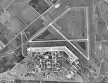 USGS aerial photo - 28 January 1995 | |||||||||||||||||||
| Summary | |||||||||||||||||||
| Airport type | Public | ||||||||||||||||||
| Owner/Operator | City of San Marcos | ||||||||||||||||||
| Serves | San Marcos, Texas | ||||||||||||||||||
| Location | San Marcos, Caldwell County, Texas, USA | ||||||||||||||||||
| Elevation AMSL | 594.7 ft / 181 m | ||||||||||||||||||
| Coordinates | 29°53′34″N 097°51′47″W / 29.89278°N 97.86306°W | ||||||||||||||||||
| Map | |||||||||||||||||||
 HYI Location of airport in Texas / United States | |||||||||||||||||||
| Runways | |||||||||||||||||||
| |||||||||||||||||||
| Statistics (2015) | |||||||||||||||||||
| |||||||||||||||||||


San Marcos Regional Airport (ICAO: KHYI, FAA LID: HYI) is a public use airport located in Caldwell County, Texas, United States. It is four nautical miles (7 km) east of the central business district of San Marcos, a city that is mostly in Hays County. The airport is owned by the City of San Marcos and operated by Texas Aviation Partners.[1] It is located east of the border of Caldwell County and Hays County.[2] Before it was operated as a civilian airport it was known as Gary Air Force Base.
Although most U.S. airports use the same three-letter location identifier for the FAA and IATA, this airport is assigned HYI by the FAA but has no designation from the IATA.[3]
History[]
Military[]
It was the site of the Gary Army Airfield
Civilian[]
Organized San Marcans fought to save the base, and on November 20, 1964, President Lyndon B. Johnson announced in a speech at his alma mater, Southwest Texas State University, that the abandoned Camp Gary would be the site of a new federal vocational training facility called Job Corps. Today it's known as the Gary Job Corps Center, the largest in the nation.
In 2014, the airport was selected to be the location for the Aircraft Owners and Pilots Association's regional fly-in.[4]
Facilities and aircraft[]
San Marcos Regional Airport covers an area of 1,393 acres (564 ha) at an elevation of 597 feet (182 m) above mean sea level. It has three asphalt paved runways: 8/26 is 6,330 by 100 feet (1,929 x 30 m), 13/31 is 5,603 by 150 feet (1,708 x 46 m) and 17/35 is 5,213 by 100 feet (1,589 x 30 m).[1]
For the 12-month period ending September 30, 2015, the airport had 46,422 aircraft operations, an average of 127 per day: 98% general aviation, 2% military and <1% air taxi. At that time there were 108 aircraft based at this airport: 76% single-engine, 20% multi-engine and 4% jet.[1]
Accidents and incidents[]
- Two airplanes collided on September 24, 2020 while attempting to land at San Marcos Regional Airport. Two men in one of the planes were injured while the pilot and sole occupant of the second one was uninjured. One of the planes burned and the second one crashed under-turned.[5]
See also[]
References[]
- ^ Jump up to: a b c d FAA Airport Form 5010 for HYI PDF, effective 2009-05-07.
- ^ MapQuest: San Marcos Municipal Airport
- ^ Great Circle Mapper: KHYI - San Marcos, Texas
- ^ "Pancakes Barbecue and Aviation". AOPA Pilot: 39. June 2014.
- ^ https://www.kvue.com/article/news/local/two-planes-involved-in-crash-at-san-marcos-regional-airport/269-61030b04-f53a-4508-809e-7f6d3ab61c68
External links[]
- FAA Terminal Procedures for HYI, effective September 9, 2021
- Resources for this airport:
- FAA airport information for HYI
- AirNav airport information for KHYI
- FlightAware airport information and live flight tracker
- NOAA/NWS weather observations: current, past three days
- SkyVector aeronautical chart, Terminal Procedures
| show Authority control |
|---|
- San Marcos, Texas
- Airports in Texas
- Buildings and structures in Caldwell County, Texas
- Transportation in Caldwell County, Texas
- Transportation in Hays County, Texas
- Airports in Greater Austin