Sandyston Township, New Jersey
Sandyston Township, New Jersey | |
|---|---|
| Township of Sandyston | |
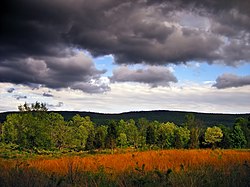 Autumn landscape | |
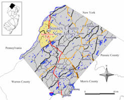 Map of Sandyston Township in Sussex County. Inset: Location of Sussex County highlighted in the State of New Jersey. | |
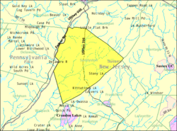 Census Bureau map of Sandyston Township, New Jersey | |
 Sandyston Township Location in Sussex County | |
| Coordinates: 41°12′49″N 74°48′49″W / 41.213621°N 74.81353°WCoordinates: 41°12′49″N 74°48′49″W / 41.213621°N 74.81353°W[1][2] | |
| Country | |
| State | |
| County | |
| Royal charter | February 26, 1762 |
| Incorporated | February 21, 1798 |
| Government | |
| • Type | Township |
| • Body | Township Committee |
| • Mayor | George B. Harper Jr. (R, term ends December 31, 2020)[3][4] |
| • Municipal clerk | Amanda Lobban[5] |
| Area | |
| • Total | 42.06 sq mi (108.94 km2) |
| • Land | 41.33 sq mi (107.05 km2) |
| • Water | 0.73 sq mi (1.89 km2) 1.74% |
| Area rank | 48th of 565 in state 4th of 24 in county[1] |
| Elevation | 692 ft (211 m) |
| Population | |
| • Total | 1,998 |
| • Estimate (2019)[11] | 1,823 |
| • Rank | 486th of 566 in state 21st of 24 in county[12] |
| • Density | 47.0/sq mi (18.1/km2) |
| • Density rank | 555th of 566 in state 23rd of 24 in county[12] |
| Time zone | UTC−05:00 (Eastern (EST)) |
| • Summer (DST) | UTC−04:00 (Eastern (EDT)) |
| ZIP Code | 07826 - Branchville[13] |
| Area code(s) | 973[14] |
| FIPS code | 3403765700[1][15][16] |
| GNIS feature ID | 0882255[1][17] |
| Website | www |


Sandyston Township is a small rural township in Sussex County, New Jersey, United States, located in the northwestern part of the state near the Pennsylvania border. The township is surrounded by and part of many national and state parks. As of the 2010 United States census, the township's population was 1,998,[8][9][10] reflecting an increase of 173 (+9.5%) from the 1,825 counted in the 2000 census, which had in turn increased by 93 (+5.4%) from the 1,732 counted in the 1990 census.[18] Sandyston's growth in recent years has been attributed to the influx of people from more urban parts of the state and even New York City, located less than 75 miles (121 km) away.
New Jersey Monthly magazine ranked Sandyston Township as its 26th best place to live in its 2008 rankings of the "Best Places To Live" in New Jersey.[19]
Sandyston was first formed by royal charter on February 26, 1762, from portions of Walpack Township. Sandyston was incorporated as a township on February 21, 1798, by an act of the New Jersey Legislature as part of the initial group of 104 townships incorporated in the state.[20]
Geography[]
According to the United States Census Bureau, the township had a total area of 42.06 square miles (108.94 km2), including 41.33 square miles (107.05 km2) of land and 0.73 square miles (1.89 km2) of water (1.74%).[1][2]
The township ranges from 300 to 1,600 feet (91 to 488 m) above sea level. A ridge runs along the eastern half of the township called the Kittatinny Mountains. The highest point in the township is Sunrise Mountain in Stokes State Forest. The lowest point is around the Delaware River in the western half of the township.
Unincorporated communities, localities and place names located partially or completely within the township include Abertown, Bevans, Centerville, Dingmans Ferry, Hainesville, Kittatinny Lake, Lake Ashroe, Layton, Namanack Island, Normanock, Peters Valley, Shaytown, Stoney Lake and Tuttles Corner.[21]
Sandyston Township borders the Sussex County municipalities of Frankford Township, Montague Township and Walpack Township.[22][23]
Demographics[]
| Historical population | |||
|---|---|---|---|
| Census | Pop. | %± | |
| 1810 | 703 | — | |
| 1820 | 858 | 22.0% | |
| 1830 | 1,097 | 27.9% | |
| 1840 | 1,209 | 10.2% | |
| 1850 | 1,327 | 9.8% | |
| 1860 | 1,480 | 11.5% | |
| 1870 | 1,230 | −16.9% | |
| 1880 | 1,195 | −2.8% | |
| 1890 | 1,084 | −9.3% | |
| 1900 | 939 | −13.4% | |
| 1910 | 855 | −8.9% | |
| 1920 | 727 | −15.0% | |
| 1930 | 610 | −16.1% | |
| 1940 | 651 | 6.7% | |
| 1950 | 829 | 27.3% | |
| 1960 | 1,019 | 22.9% | |
| 1970 | 1,303 | 27.9% | |
| 1980 | 1,485 | 14.0% | |
| 1990 | 1,732 | 16.6% | |
| 2000 | 1,825 | 5.4% | |
| 2010 | 1,998 | 9.5% | |
| 2019 (est.) | 1,823 | [11][24] | −8.8% |
| Population sources: 1800-1920[25] 1840[26] 1850-1870[27] 1850[28] 1870[29] 1880-1890[30] 1890-1910[31] 1910-1930[32] 1930-1990[33] 2000[34][35] 2010[8][9][10] | |||
Census 2010[]
The 2010 United States census counted 1,998 people, 788 households, and 561 families in the township. The population density was 47.0 per square mile (18.1/km2). There were 988 housing units at an average density of 23.2 per square mile (9.0/km2). The racial makeup was 97.45% (1,947) White, 0.40% (8) Black or African American, 0.10% (2) Native American, 0.55% (11) Asian, 0.00% (0) Pacific Islander, 0.30% (6) from other races, and 1.20% (24) from two or more races. Hispanic or Latino of any race were 3.40% (68) of the population.[8]
Of the 788 households, 29.9% had children under the age of 18; 58.8% were married couples living together; 7.9% had a female householder with no husband present and 28.8% were non-families. Of all households, 22.6% were made up of individuals and 7.6% had someone living alone who was 65 years of age or older. The average household size was 2.54 and the average family size was 3.01.[8]
22.5% of the population were under the age of 18, 7.7% from 18 to 24, 21.6% from 25 to 44, 36.5% from 45 to 64, and 11.7% who were 65 years of age or older. The median age was 43.7 years. For every 100 females, the population had 98.8 males. For every 100 females ages 18 and older there were 98.6 males.[8]
The Census Bureau's 2006-2010 American Community Survey showed that (in 2010 inflation-adjusted dollars) median household income was $73,750 (with a margin of error of +/- $8,449) and the median family income was $96,071 (+/- $15,669). Males had a median income of $62,071 (+/- $9,210) versus $41,875 (+/- $7,589) for females. The per capita income for the borough was $40,921 (+/- $9,604). About 2.5% of families and 2.4% of the population were below the poverty line, including none of those under age 18 and 2.2% of those age 65 or over.[36]
Census 2000[]
As of the 2000 United States census[15] there were 1,825 people, 693 households, and 503 families residing in the township. The population density was 42.8 people per square mile (16.5/km2). There were 907 housing units at an average density of 21.3 per square mile (8.2/km2). The racial makeup of the township was 97.86% White, 0.38% African American, 0.16% Native American, 0.44% Asian, 0.11% Pacific Islander, 0.05% from other races, and 0.99% from two or more races. Hispanic or Latino of any race were 1.32% of the population.[34][35]
There were 793 households, out of which 35.2% had children under the age of 18 living with them, 62.9% were married couples living together, 5.9% had a female householder with no husband present, and 27.3% were non-families. 22.8% of all households were made up of individuals, and 9.7% had someone living alone who was 65 years of age or older. The average household size was 2.63 and the average family size was 3.12.[34][35]
In the township the population was spread out, with 25.2% under the age of 18, 6.0% from 18 to 24, 28.5% from 25 to 44, 26.9% from 45 to 64, and 13.4% who were 65 years of age or older. The median age was 40 years. For every 100 females, there were 101.4 males. For every 100 females age 18 and over, there were 99.6 males.[34][35]
The median income for a household in the township was $55,667, and the median income for a family was $65,774. Males had a median income of $46,167 versus $30,660 for females. The per capita income for the township was $23,854. About 3.6% of families and 5.4% of the population were below the poverty line, including 6.8% of those under age 18 and 6.4% of those age 65 or over.[34][35]
Parks and recreation[]
- Delaware Water Gap National Recreation Area and Stokes State Forest cover more than two-thirds of the township[37]
- Brau Kettle[38]
Government[]
Local government[]
Sandyston Township is governed under the township form of New Jersey municipal government, one of 141 municipalities (of the 565) statewide that use this form, the second-most commonly used form of government in the state.[39] The governing body is comprised of the three-person Township Committee, whose members are elected directly by the voters in partisan elections to serve three-year terms of office on a staggered basis, with one seat coming up for election each year as part of the November general election.[6][40] At an annual reorganization meeting, the Township Committee selects one of its members to serve as Mayor and another as Deputy Mayor.
As of 2020, members of the Sandyston Township Committee are Mayor George B. Harper Jr. (R, term on committee and as mayor ends December 31, 2020), Deputy Mayor Kamala M. "Kammy" Hull (R, term on committee ends 2022; term as deputy mayor ends 2020) and Frederick V. MacDonald (R, 2021).[3][41][42][43][44]
In January 2016, the Township Committee selected Kamala "Kammy" Hull from three names nominated by the Republican municipal committee to fill the seat expiring in December 2016 that had been held by William J. Leppert until his resignation effective the previous month; Hull will serve on an interim basis until the November 2016 general election, when voters will select a candidate to serve the balance of the term of office.[45][46]
Federal, state and county representation[]
Sandyston Township is located in the 5th Congressional District[47] and is part of New Jersey's 24th state legislative district.[9][48][49]
For the 117th United States Congress, New Jersey's Fifth Congressional District is represented by Josh Gottheimer (D, Wyckoff).[50][51] New Jersey is represented in the United States Senate by Democrats Cory Booker (Newark, term ends 2027)[52] and Bob Menendez (Harrison, term ends 2025).[53][54]
For the 2018–2019 session (Senate, General Assembly), the 24th Legislative District of the New Jersey Legislature is represented in the State Senate by Steve Oroho (R, Franklin) and in the General Assembly by Parker Space (R, Wantage Township) and Harold J. Wirths (R, Hamburg).[55][56]
Sussex County is governed by a Board of Chosen Freeholders whose five members are elected at-large in partisan elections on a staggered basis, with either one or two seats coming up for election each year. At an annual reorganization meeting held in the beginning of January, the board selects a Freeholder Director and Deputy Director from among its members, with day-to-day supervision of the operation of the county delegated to a County Administrator.[57] As of 2014, Sussex County's Freeholders are Freeholder Director Richard Vohden (R, Green Township, 2016),[58] Deputy Director Dennis J. Mudrick (R, Sparta Township, 2015),[59] Phillip R. Crabb (R, Franklin, 2014),[60] George Graham (R, Stanhope, 2016)[61] and Gail Phoebus (R, Andover Township, 2015).[62][57] Graham was chosen in April 2013 to fill the seat vacated by Parker Space, who had been chosen to fill a vacancy in the New Jersey General Assembly.[63] Constitutional officers elected on a countywide basis are County Clerk Jeff Parrott (R, 2016),[64] Sheriff Michael F. Strada (R, 2016)[65] and Surrogate Gary R. Chiusano (R, filling the vacancy after the resignation of Nancy Fitzgibbons).[66][63] The County Administrator is John Eskilson.[67][68]
Politics[]
As of March 23, 2011, there were a total of 1,349 registered voters in Sandyston Township, of which 193 (14.3% vs. 16.5% countywide) were registered as Democrats, 662 (49.1% vs. 39.3%) were registered as Republicans and 492 (36.5% vs. 44.1%) were registered as Unaffiliated. There were 2 voters registered to other parties.[69] Among the township's 2010 census population, 67.5% (vs. 65.8% in Sussex County) were registered to vote, including 87.1% of those ages 18 and over (vs. 86.5% countywide).[69][70]
In the 2012 presidential election, Republican Mitt Romney received 661 votes (65.1% vs. 59.4% countywide), ahead of Democrat Barack Obama with 327 votes (32.2% vs. 38.2%) and other candidates with 24 votes (2.4% vs. 2.1%), among the 1,015 ballots cast by the township's 1,392 registered voters, for a turnout of 72.9% (vs. 68.3% in Sussex County).[71] In the 2008 presidential election, Republican John McCain received 655 votes (64.0% vs. 59.2% countywide), ahead of Democrat Barack Obama with 353 votes (34.5% vs. 38.7%) and other candidates with 9 votes (0.9% vs. 1.5%), among the 1,024 ballots cast by the township's 1,328 registered voters, for a turnout of 77.1% (vs. 76.9% in Sussex County).[72] In the 2004 presidential election, Republican George W. Bush received 638 votes (67.7% vs. 63.9% countywide), ahead of Democrat John Kerry with 291 votes (30.9% vs. 34.4%) and other candidates with 12 votes (1.3% vs. 1.3%), among the 943 ballots cast by the township's 1,163 registered voters, for a turnout of 81.1% (vs. 77.7% in the whole county).[73]
In the 2013 gubernatorial election, Republican Chris Christie received 73.5% of the vote (496 cast), ahead of Democrat Barbara Buono with 23.1% (156 votes), and other candidates with 3.4% (23 votes), among the 678 ballots cast by the township's 1,423 registered voters (3 ballots were spoiled), for a turnout of 47.6%.[74][75] In the 2009 gubernatorial election, Republican Chris Christie received 475 votes (65.6% vs. 63.3% countywide), ahead of Democrat Jon Corzine with 157 votes (21.7% vs. 25.7%), Independent Chris Daggett with 77 votes (10.6% vs. 9.1%) and other candidates with 10 votes (1.4% vs. 1.3%), among the 724 ballots cast by the township's 1,303 registered voters, yielding a 55.6% turnout (vs. 52.3% in the county).[76]
Education[]
Public school students in kindergarten through sixth grade attend the schools of the Sandyston-Walpack Consolidated School District, together with students from Walpack Township.[77] The school is located in the Layton section of Sandyston Township. As of the 2018–19 school year, the district, comprised of one school, had an enrollment of 138 students and 16.9 classroom teachers (on an FTE basis), for a student–teacher ratio of 8.2:1.[78] In the 2016–17 school year, Sandyston-Walpack had the 26th smallest enrollment of any school district in the state, with 149 students.[79]
Students in seventh through twelfth grade from Sandyston and Walpack Townships for public school attend Kittatinny Regional High School located in Hampton Township, which also serves students who reside in Fredon Township and Stillwater Township.[80][81] The high school is located on a 96-acre (39 ha) campus in Hampton Township, about seven minutes outside of the county seat of Newton. Kittatinny Regional High School was recognized as a National Blue Ribbon School of Excellence in 1997–98.[82] As of the 2018–19 school year, the high school had an enrollment of 941 students and 97.5 classroom teachers (on an FTE basis), for a student–teacher ratio of 9.7:1.[83]
Transportation[]

As of May 2010, the township had a total of 52.47 miles (84.44 km) of roadways, of which 28.98 miles (46.64 km) were maintained by the municipality, 16.22 miles (26.10 km) by Sussex County and 7.27 miles (11.70 km) by the New Jersey Department of Transportation.[84]
U.S. Route 206 bisects the township, concurrent with County Route 521. The Dingman's Ferry Bridge, one of the last privately owned toll bridges on the Delaware River and one of the last few in the United States, carries two lanes of PA 739 and NJ County Route 560, connecting to Delaware Township, Pike County, Pennsylvania.[85]
Notable people[]
People who were born in, residents of, or otherwise closely associated with Sandyston Township include:
- George B. Harper (1918-1988), politician who served in the New Jersey Senate from 1954 to 1964.[86]
- Harry Harper (1895-1963), pitcher who played in the major leagues for four different teams.[87]
- Bill Sienkiewicz (born 1958), artist known for his work in comic books, particularly for Marvel Comics' New Mutants, Moon Knight, and Elektra: Assassin.[88]
References[]
- ^ Jump up to: a b c d e f 2019 Census Gazetteer Files: New Jersey Places, United States Census Bureau. Accessed July 1, 2020.
- ^ Jump up to: a b US Gazetteer files: 2010, 2000, and 1990, United States Census Bureau. Accessed September 4, 2014.
- ^ Jump up to: a b Township Committee, Sandyston Township. Accessed August 2, 2016.
- ^ 2020 New Jersey Mayors Directory, New Jersey Department of Community Affairs. Accessed February 1, 2020.
- ^ Township Clerk, Sandyston Township. Accessed March 5, 2020.
- ^ Jump up to: a b 2012 New Jersey Legislative District Data Book, Rutgers University Edward J. Bloustein School of Planning and Public Policy, March 2013, p. 110.
- ^ U.S. Geological Survey Geographic Names Information System: Township of Sandyston, Geographic Names Information System. Accessed March 14, 2013.
- ^ Jump up to: a b c d e f DP-1 - Profile of General Population and Housing Characteristics: 2010 for Sandyston township, Sussex County, New Jersey Archived February 12, 2020, at archive.today, United States Census Bureau. Accessed February 25, 2013.
- ^ Jump up to: a b c d Municipalities Sorted by 2011-2020 Legislative District, New Jersey Department of State. Accessed February 1, 2020.
- ^ Jump up to: a b c Profile of General Demographic Characteristics: 2010 for Sandyston township Archived June 5, 2015, at the Wayback Machine, New Jersey Department of Labor and Workforce Development. Accessed February 25, 2013.
- ^ Jump up to: a b Annual Estimates of the Resident Population for Minor Civil Divisions in New Jersey: April 1, 2010 to July 1, 2019, United States Census Bureau. Accessed May 21, 2020.
- ^ Jump up to: a b GCT-PH1 Population, Housing Units, Area, and Density: 2010 - State -- County Subdivision from the 2010 Census Summary File 1 for New Jersey Archived February 12, 2020, at archive.today, United States Census Bureau. Accessed February 25, 2013.
- ^ Look Up a ZIP Code for Branchville, NJ, United States Postal Service. Accessed February 25, 2013.
- ^ Area Code Lookup - NPA NXX for Sandyston, NJ, Area-Codes.com. Accessed October 24, 2014.
- ^ Jump up to: a b U.S. Census website , United States Census Bureau. Accessed September 4, 2014.
- ^ Geographic codes for New Jersey, Missouri Census Data Center. Accessed September 1, 2019.
- ^ US Board on Geographic Names, United States Geological Survey. Accessed September 4, 2014.
- ^ Table 7. Population for the Counties and Municipalities in New Jersey: 1990, 2000 and 2010, New Jersey Department of Labor and Workforce Development, February 2011. Accessed February 25, 2013.
- ^ "Best Places To Live - The Complete Top Towns List 1-100" Archived 2008-02-28 at the Wayback Machine, New Jersey Monthly, February 21, 2008. Accessed February 24, 2008.
- ^ Snyder, John P. The Story of New Jersey's Civil Boundaries: 1606-1968, Bureau of Geology and Topography; Trenton, New Jersey; 1969. p. 232. Accessed October 23, 2012.
- ^ Locality Search, State of New Jersey. Accessed April 14, 2015.
- ^ Sussex County Map, Sussex County, New Jersey. Accessed March 1, 2020.
- ^ New Jersey Municipal Boundaries, New Jersey Department of Transportation. Accessed November 15, 2019.
- ^ Census Estimates for New Jersey April 1, 2010 to July 1, 2019, United States Census Bureau. Accessed May 21, 2020.
- ^ Compendium of censuses 1726-1905: together with the tabulated returns of 1905, New Jersey Department of State, 1906. Accessed July 19, 2013.
- ^ Bowen, Francis. American Almanac and Repository of Useful Knowledge for the Year 1843, p. 231, David H. Williams, 1842. Accessed February 25, 2013.
- ^ Raum, John O. The History of New Jersey: From Its Earliest Settlement to the Present Time, Volume 1, p. 271, J. E. Potter and company, 1877. Accessed February 25, 2013. "Sandyston is the most western township and borders on Pennsylvania. Its population in 1850 was 1,327; in 1860, 1,480 and in 1870, 1,230."
- ^ Debow, James Dunwoody Brownson. The Seventh Census of the United States: 1850, p. 141. R. Armstrong, 1853. Accessed February 25, 2013.
- ^ Staff. A compendium of the ninth census, 1870, p. 260. United States Census Bureau, 1872. Accessed February 25, 2013.
- ^ Porter, Robert Percival. Preliminary Results as Contained in the Eleventh Census Bulletins: Volume III - 51 to 75, p. 97. United States Census Bureau, 1890. Accessed February 25, 2013.
- ^ Thirteenth Census of the United States, 1910: Population by Counties and Minor Civil Divisions, 1910, 1900, 1890, United States Census Bureau, p. 338. Accessed August 30, 2012.
- ^ Fifteenth Census of the United States : 1930 - Population Volume I, United States Census Bureau, p. 719. Accessed February 25, 2013.
- ^ Table 6. New Jersey Resident Population by Municipality: 1930 - 1990, New Jersey Department of Labor and Workforce Development. Accessed August 9, 2016.
- ^ Jump up to: a b c d e Census 2000 Profiles of Demographic / Social / Economic / Housing Characteristics for Sandyston township, Sussex County, New Jersey Archived June 5, 2015, at the Wayback Machine, United States Census Bureau. Accessed February 25, 2013.
- ^ Jump up to: a b c d e DP-1: Profile of General Demographic Characteristics: 2000 - Census 2000 Summary File 1 (SF 1) 100-Percent Data for Sandyston township, Sussex County, New Jersey Archived February 12, 2020, at archive.today, United States Census Bureau. Accessed February 25, 2013.
- ^ DP03: Selected Economic Characteristics from the 2006-2010 American Community Survey 5-Year Estimates for Sandyston township, Sussex County, New Jersey Archived February 12, 2020, at archive.today, United States Census Bureau. Accessed February 25, 2013.
- ^ A Brief History of Sandyston, Sandyston Township. Accessed July 24, 2013. "Sandyston Township measures only 42 square miles and includes Stokes State Forest and the Delaware Water Gap Recreation Area, which renders 70 percent of the township tax exempt."
- ^ Dalton, Richard F. Caves of New Jersey, New Jersey Department of Environmental Protection - New Jersey Geological Survey. Accessed February 25, 2013.
- ^ Inventory of Municipal Forms of Government in New Jersey, Rutgers University Center for Government Studies, July 1, 2011. Accessed November 18, 2019.
- ^ "Forms of Municipal Government in New Jersey", p. 7. Rutgers University Center for Government Studies. Accessed June 3, 2015.
- ^ 2019 Municipal User Friendly Budget, Sandyston Township. Accessed March 5, 2020.
- ^ Sussex County, New Jersey General Election November 5, 2019, Official Results Summary Report, Sussex County, New Jersey, dated November 8, 2019. Accessed January 1, 2020.
- ^ Sussex County, New Jersey General Election November 6, 2018, Official Results Summary Report, Sussex County, New Jersey, dated November 9, 2018. Accessed January 1, 2019.
- ^ Sussex County, New Jersey General Election November 7, 2017, Official Results Summary Report, Sussex County, New Jersey, dated November 9, 2017. Accessed January 1, 2018.
- ^ Reorganization Meeting Minutes January 4, 2016, Sandyston Township. Accessed August 2, 2016. "With the resignation of William J. Leppert from the Township Committee, effective December 31, 2015, the Clerk presented a list of three names prepared by the Sandyston Township Municipal Committee to fill the unexpired term set to expire December 31, 2016. The three names presented were Kamala M. Hull, Kelly Hanlon and Keith Utter. Mayor Harper stated Mayor Harper made a motion to appoint Kamala Hull to fill the unexpired term of William J. Leppert, left vacant by his resignation, seconded by Deputy Mayor MacDonald and unanimously carried."
- ^ Comstock, Lori. "Sandyston incumbent beats out challenger", New Jersey Herald, June 8, 2016. Accessed August 2, 2016. "Kamala Hull had been appointed to the Township Committee in January to fill the unexpired term of William J. Leppert, who had resigned in December."
- ^ Plan Components Report, New Jersey Redistricting Commission, December 23, 2011. Accessed February 1, 2020.
- ^ 2019 New Jersey Citizen's Guide to Government, New Jersey League of Women Voters. Accessed October 30, 2019.
- ^ Districts by Number for 2011-2020, New Jersey Legislature. Accessed January 6, 2013.
- ^ Directory of Representatives: New Jersey, United States House of Representatives. Accessed January 3, 2019.
- ^ Biography, Congressman Josh Gottheimer. Accessed January 3, 2019. "Josh now lives in Wyckoff, New Jersey with Marla, his wife who was a federal prosecutor, and their two young children, Ellie and Ben."
- ^ [1], United States Senate. Accessed April 30, 2021. "He now owns a home and lives in Newark's Central Ward community."
- ^ Biography of Bob Menendez, United States Senate, January 26, 2015. "Menendez, who started his political career in Union City, moved in September from Paramus to one of Harrison's new apartment buildings near the town's PATH station.."
- ^ [2]. United States Senate. Accessed April 30, 2021. "Booker, Cory A. - (D - NJ) Class II; Menendez, Robert - (D - NJ) Class I"
- ^ Legislative Roster 2018-2019 Session, New Jersey Legislature. Accessed January 22, 2018.
- ^ District 24 Legislators, New Jersey Legislature. Accessed January 22, 2018.
- ^ Jump up to: a b Sussex County Board of Chosen Freeholders, Sussex County, New Jersey. Accessed July 28, 2014.
- ^ Richard A. Vohden, Sussex County, New Jersey. Accessed July 28, 2014.
- ^ Dennis J. Mudrick, Sussex County, New Jersey. Accessed July 28, 2014.
- ^ Phillip R. Crabb, Sussex County, New Jersey. Accessed July 28, 2014.
- ^ George Graham, Sussex County, New Jersey. Accessed July 28, 2014.
- ^ Gail Phoebus, Sussex County, New Jersey. Accessed July 28, 2014.
- ^ Jump up to: a b Miller, Jennifer Jean. "George Graham Chosen as Freeholder at Sussex County Republican Convention", TheAlternativePress.com, April 13, 2013. Accessed April 25, 2013. "Graham will fill the freeholder seat that New Jersey Assemblyman Parker Space left to take his new position. Space recently took the seat, which formerly belonged to Gary Chiusano, who in turn, was appointed to the spot of Sussex County Surrogate, following the retirement of Surrogate Nancy Fitzgibbons."
- ^ Home Page, Sussex County Clerk's Office. Accessed July 28, 2014.
- ^ Sheriff's Office, Sussex County, New Jersey. Accessed July 28, 2014.
- ^ Home Page, Sussex County Surrogate. Accessed July 28, 2014.
- ^ County Administrator, Sussex County, New Jersey. Accessed July 28, 2014.
- ^ Sussex County Official Directory 2014, Sussex County, New Jersey. Accessed July 28, 2014.
- ^ Jump up to: a b Voter Registration Summary - Sussex, New Jersey Department of State Division of Elections, March 23, 2011. Accessed February 25, 2013.
- ^ GCT-P7: Selected Age Groups: 2010 - State -- County Subdivision; 2010 Census Summary File 1 for New Jersey Archived February 12, 2020, at archive.today, United States Census Bureau. Accessed February 25, 2013.
- ^ General Election November 6, 2012: District Report - Group Detail Archived June 6, 2013, at the Wayback Machine, Sussex County, New Jersey Clerk, run date November 30, 2012. Accessed February 25, 2013.
- ^ 2008 Presidential General Election Results: Sussex County, New Jersey Department of State Division of Elections, December 23, 2008. Accessed February 25, 2013.
- ^ 2004 Presidential Election: Sussex County, New Jersey Department of State Division of Elections, December 13, 2004. Accessed February 25, 2013.
- ^ "Governor - Sussex County" (PDF). New Jersey Department of Elections. January 29, 2014. Retrieved December 24, 2014.
- ^ "Number of Registered Voters and Ballots Cast - November 5, 2013 - General Election Results - Sussex County" (PDF). New Jersey Department of Elections. January 29, 2014. Retrieved December 24, 2014.
- ^ 2009 Governor: Sussex County Archived June 6, 2013, at the Wayback Machine, New Jersey Department of State Division of Elections, December 31, 2009. Accessed February 25, 2013.
- ^ About, Sandyston-Walpack Consolidated School District. Accessed June 22, 2020. "The Sandyston-Walpack Consolidated School is a K-6 district with an enrollment of about 120 students. The school is located in a beautiful portion of northwest New Jersey. The elementary students who live in the townships of Sandyston and Walpack attend here. The students of middle and high school age attend Kittatinny Regional High School located in Hampton Township."
- ^ District information for Sandyston-Walpack Consolidated School District, National Center for Education Statistics. Accessed April 1, 2020.
- ^ Guion, Payton. "These 43 N.J. school districts have fewer than 200 students", NJ Advance Media for NJ.com, September 2017. Accessed January 30, 2020. "Based on data from the state Department of Education from the last school year and the Census Bureau, NJ Advance Media made a list of the smallest of the small school districts in the state, excluding charter schools and specialty institutions.... 26. Sandyston-Walpack Township (tie;) Enrollment: 149; Grades: K-6; County: Sussex; Town population: 2,014"
- ^ Kittatiny Regional School District 2016 Report Card Narrative, New Jersey Department of Education. Accessed June 22, 2020. "Located in beautiful, rural Sussex County in northwest New Jersey, Kittatinny Regional School District serves the five municipalities of Fredon Township, Hampton Township, Sandyston Township, Stillwater Township and the Township of Walpack. The District is comprised of 125 square miles and has a school population of approximately 1020 students."
- ^ Kittatinny has a New Look, Kittatinny Regional High School. Accessed June 22, 2020. "Located in beautiful, rural Sussex County in northwest New Jersey, Kittatinny Regional School District serves the five municipalities of Fredon Township, Hampton Township, Sandyston Township, Stillwater Township and the Township of Walpack. The District is comprised of 125 square miles and has a school population of approximately 1020 students."
- ^ Blue Ribbon Schools Program: Schools Recognized 1982-1983 through 1999-2002 (PDF), United States Department of Education. Accessed June 22, 2020.
- ^ School data for Kittatinny Regional High School, National Center for Education Statistics. Accessed April 1, 2020.
- ^ Sussex County Mileage by Municipality and Jurisdiction, New Jersey Department of Transportation, May 2010. Accessed July 18, 2014.
- ^ History, Dingmans Choice and Delaware Bridge Company. Accessed February 25, 2013.
- ^ Staff. "George B. Harper Sr. '41", Princeton Alumni Weekly, Volume 88. Accessed January 5, 2017. "George died at his home in Layton. N.J., on Mar. 1, 1988."
- ^ Barbati, Carl. "Sussex Hall of Fame welcomes new members", New Jersey Herald, November 19, 2012. Accessed January 5, 2017. "Harry Harper, Layton (1913-23, Senators, Red Sox, Yankees, Dodgers)"
- ^ Greenfield, Dan. "How a Meeting at DC Led Bill Sienkiewicz to Marvel’S Moon Knight", 13th Dimension, November 10, 2019. Accessed August 31, 2020. "[Dan Greenfield:] Where was it that you grew up? [Bill Sienkiewicz:] I grew up in northern New Jersey, an area called Hainesville. … I was a farm kid, I was baling hay and stuff."
External links[]
| Wikimedia Commons has media related to Sandyston Township, New Jersey. |
- Sandyston Township
- Web page for Sandyston Township, Sussex County, New Jersey
- Sandyston-Walpack Consolidated School
- Sandyston-Walpack Consolidated School's 2015–16 School Performance Report from the New Jersey Department of Education
- Data for Sandyston-Walpack Consolidated School, National Center for Education Statistics
- Kittatinny Regional High School
| show Municipalities and communities of Sussex County, New Jersey, United States |
|---|

| show Places adjacent to Sandyston Township, New Jersey |
|---|
- Sandyston Township, New Jersey
- 1798 establishments in New Jersey
- Delaware Water Gap National Recreation Area
- Populated places established in 1798
- Township form of New Jersey government
- Townships in Sussex County, New Jersey
- New Jersey populated places on the Delaware River