Santa Monica Air Line
| Santa Monica Air Line | |||||||||||||||||||||||||||||||||||||||||||||||||||||||||||||||||||||||||||||||||||||||||||||||||||||||||||||||||||||||||||||||||||||||||||||||||||||||||||||||||||||||||||||||||||||||||||||||||||||
|---|---|---|---|---|---|---|---|---|---|---|---|---|---|---|---|---|---|---|---|---|---|---|---|---|---|---|---|---|---|---|---|---|---|---|---|---|---|---|---|---|---|---|---|---|---|---|---|---|---|---|---|---|---|---|---|---|---|---|---|---|---|---|---|---|---|---|---|---|---|---|---|---|---|---|---|---|---|---|---|---|---|---|---|---|---|---|---|---|---|---|---|---|---|---|---|---|---|---|---|---|---|---|---|---|---|---|---|---|---|---|---|---|---|---|---|---|---|---|---|---|---|---|---|---|---|---|---|---|---|---|---|---|---|---|---|---|---|---|---|---|---|---|---|---|---|---|---|---|---|---|---|---|---|---|---|---|---|---|---|---|---|---|---|---|---|---|---|---|---|---|---|---|---|---|---|---|---|---|---|---|---|---|---|---|---|---|---|---|---|---|---|---|---|---|---|---|---|
 | |||||||||||||||||||||||||||||||||||||||||||||||||||||||||||||||||||||||||||||||||||||||||||||||||||||||||||||||||||||||||||||||||||||||||||||||||||||||||||||||||||||||||||||||||||||||||||||||||||||
 The Air Line looking west from Ivy station (later Culver Junction), with the junction and station building in the foreground, 1905 | |||||||||||||||||||||||||||||||||||||||||||||||||||||||||||||||||||||||||||||||||||||||||||||||||||||||||||||||||||||||||||||||||||||||||||||||||||||||||||||||||||||||||||||||||||||||||||||||||||||
| Overview | |||||||||||||||||||||||||||||||||||||||||||||||||||||||||||||||||||||||||||||||||||||||||||||||||||||||||||||||||||||||||||||||||||||||||||||||||||||||||||||||||||||||||||||||||||||||||||||||||||||
| Owner | Southern Pacific Railroad | ||||||||||||||||||||||||||||||||||||||||||||||||||||||||||||||||||||||||||||||||||||||||||||||||||||||||||||||||||||||||||||||||||||||||||||||||||||||||||||||||||||||||||||||||||||||||||||||||||||
| Locale | Los Angeles | ||||||||||||||||||||||||||||||||||||||||||||||||||||||||||||||||||||||||||||||||||||||||||||||||||||||||||||||||||||||||||||||||||||||||||||||||||||||||||||||||||||||||||||||||||||||||||||||||||||
| Termini | Pacific Electric Building Santa Monica, California | ||||||||||||||||||||||||||||||||||||||||||||||||||||||||||||||||||||||||||||||||||||||||||||||||||||||||||||||||||||||||||||||||||||||||||||||||||||||||||||||||||||||||||||||||||||||||||||||||||||
| Stations | 15 | ||||||||||||||||||||||||||||||||||||||||||||||||||||||||||||||||||||||||||||||||||||||||||||||||||||||||||||||||||||||||||||||||||||||||||||||||||||||||||||||||||||||||||||||||||||||||||||||||||||
| Service | |||||||||||||||||||||||||||||||||||||||||||||||||||||||||||||||||||||||||||||||||||||||||||||||||||||||||||||||||||||||||||||||||||||||||||||||||||||||||||||||||||||||||||||||||||||||||||||||||||||
| Type | Interurban | ||||||||||||||||||||||||||||||||||||||||||||||||||||||||||||||||||||||||||||||||||||||||||||||||||||||||||||||||||||||||||||||||||||||||||||||||||||||||||||||||||||||||||||||||||||||||||||||||||||
| System | Pacific Electric | ||||||||||||||||||||||||||||||||||||||||||||||||||||||||||||||||||||||||||||||||||||||||||||||||||||||||||||||||||||||||||||||||||||||||||||||||||||||||||||||||||||||||||||||||||||||||||||||||||||
| Operator(s) | Pacific Electric | ||||||||||||||||||||||||||||||||||||||||||||||||||||||||||||||||||||||||||||||||||||||||||||||||||||||||||||||||||||||||||||||||||||||||||||||||||||||||||||||||||||||||||||||||||||||||||||||||||||
| History | |||||||||||||||||||||||||||||||||||||||||||||||||||||||||||||||||||||||||||||||||||||||||||||||||||||||||||||||||||||||||||||||||||||||||||||||||||||||||||||||||||||||||||||||||||||||||||||||||||||
| Opened | May 26, 1909[1] | ||||||||||||||||||||||||||||||||||||||||||||||||||||||||||||||||||||||||||||||||||||||||||||||||||||||||||||||||||||||||||||||||||||||||||||||||||||||||||||||||||||||||||||||||||||||||||||||||||||
| Closed | October 26, 1953 | ||||||||||||||||||||||||||||||||||||||||||||||||||||||||||||||||||||||||||||||||||||||||||||||||||||||||||||||||||||||||||||||||||||||||||||||||||||||||||||||||||||||||||||||||||||||||||||||||||||
| Technical | |||||||||||||||||||||||||||||||||||||||||||||||||||||||||||||||||||||||||||||||||||||||||||||||||||||||||||||||||||||||||||||||||||||||||||||||||||||||||||||||||||||||||||||||||||||||||||||||||||||
| Line length | 16.88 mi (27.17 km) | ||||||||||||||||||||||||||||||||||||||||||||||||||||||||||||||||||||||||||||||||||||||||||||||||||||||||||||||||||||||||||||||||||||||||||||||||||||||||||||||||||||||||||||||||||||||||||||||||||||
| Track gauge | 1,435 mm (4 ft 8+1⁄2 in) standard gauge | ||||||||||||||||||||||||||||||||||||||||||||||||||||||||||||||||||||||||||||||||||||||||||||||||||||||||||||||||||||||||||||||||||||||||||||||||||||||||||||||||||||||||||||||||||||||||||||||||||||
| Electrification | 600 V DC Overhead lines | ||||||||||||||||||||||||||||||||||||||||||||||||||||||||||||||||||||||||||||||||||||||||||||||||||||||||||||||||||||||||||||||||||||||||||||||||||||||||||||||||||||||||||||||||||||||||||||||||||||
| |||||||||||||||||||||||||||||||||||||||||||||||||||||||||||||||||||||||||||||||||||||||||||||||||||||||||||||||||||||||||||||||||||||||||||||||||||||||||||||||||||||||||||||||||||||||||||||||||||||
The Santa Monica Air Line was an interurban railroad operated by the Pacific Electric between Santa Monica and downtown Los Angeles. It operated between 1909 and 1953.[2] Most of the route is now used by the Los Angeles County Metropolitan Transportation Authority E Line.
Route[]
Los Angeles to Culver Junction[]
Beginning at the Pacific Electric Building at Sixth and Main streets, the line crossed Los Angeles Street on a viaduct to reach San Pedro Street, where it turned south. It turned from San Pedro onto Ninth Street and ran to a right-of-way. At 25th Street and Long Beach Boulevard, at what was called Amoco (American Olive Company) Junction, the Air Line left the Watts main route and went west on a single track right-of-way diagonally across the city grid until Flower Street, where it joined Exposition Boulevard. At the west end of Exposition, the route followed Jefferson Boulevard to La Cienega, where it generally followed Washington and National Boulevards until Culver Junction.[3]
Culver Junction to Santa Monica[]
The route turned north until it crossed Overland Avenue, continued on a right-of-way between Exposition and Olympic before reaching Colorado and paralleling that road to Santa Monica. The line curved to the southeast to meet Pico just west of Main Street. It ended south of Main and Hollister at the Ocean Park car house.[3]
The table shows stops on the line in 1911, with major depots in bold:[citation needed]
| Station | Mile |
|---|---|
| Los Angeles | 0.00 |
| Nevin | 2.62 |
| Hooper | 3.05 |
| San Pedro Street | 3.77 |
| Jefferson | 4.18 |
| Grand Avenue | 4.54 |
| University | 5.40 |
| 11th Avenue | 7.68 |
| Sentous | 10.04 |
| Culver Junction (Venice Blvd and Culver Blvd) |
11.16 |
| Palms | 12.20 |
| Talamantes | 13.73 |
| Home Junction | 14.87 |
| Soldiers' Home | 15.87 |
| Bergamot | 15.25 |
| Sunset | 16.18 |
| Santa Monica | 16.88 |
| Tool House | 17.54 |
| Ocean Park | 19.20 |
History[]
The line was built in 1875 as the steam-powered Los Angeles and Independence Railroad, intended to bring mined ore to ships in Santa Monica harbor's Long Wharf and as a passenger excursion train to the beach. Purchased by Southern Pacific Railroad, it was leased to the Los Angeles Pacific Railroad for electric passenger and light freight use in 1909 — the inaugural run was made on May 26 that year.[1] Pacific Electric bought the line in 1911, along with all the other lines owned by Los Angeles Pacific. Tracks between Culver Junction and Amoco were electrified in 1912, allowing cars to reach downtown via the Watts Line.[4] The Santa Monica harbor Long Wharf was closed to shipping traffic in 1913.[5][6][7]
Service decline and end[]
With sparse population along much of the route, service on the Air Line was reduced as early as 1924, with passenger cars running only during rush hours.[7][4] At that point most passengers traveled to Santa Monica on a different rail line which ran primarily on Santa Monica Boulevard. Pacific Electric would reduce the Air Line's service frequency until 1931 when only a single daily round-trip operated over the route.[4]
The railroad tried to discontinue the service entirely as early as 1933, though patrons of the line successfully blocked every attempt.[4] By then, Pacific Electric did not print regular timetables for the Air Line, attempting to reduce ridership to strengthen their case for abandonment. Fans and users of the service would advertise the trip independently of the company.[4][8]
Passenger service on the Air Line was discontinued on October 26, 1953.[7][4] The final few weeks only saw one daily round trip run between Amoco Junction and 11th Avenue. This was Pacific Electric's only service not transferred to Metropolitan Coach Lines, which had happened to their remaining lines 25 days earlier. This marked the railroad's exit from passenger services entirely.[4]
Freight operations continued running over the tracks.[9] Because the Air Line route was also connected to the Santa Monica Boulevard line via tracks on Sepulveda Boulevard, it was the only way for freight trains to reach West Los Angeles, Beverly Hills and Hollywood warehouses (usually at night due to city regulations).

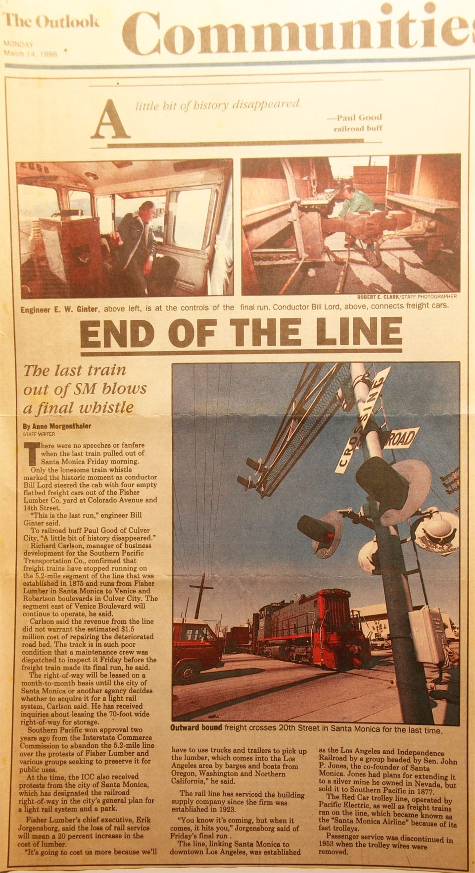
As the use of rail for transporting freight gradually declined, the tracks along Santa Monica and Sepulveda boulevards were removed and service became sparse. The tracks alongside Exposition Park occasionally also served a special purpose to hold circus trains throughout the 1980s and to store various companies' passenger cars during the 1984 Olympic Games. The final freight run was from Fisher Lumber in Santa Monica in the morning of Friday, March 11, 1988.[10] Power was provided by the Ivy Substation at 600 volts direct current until operations were converted to diesel engines.[11]
After abandonment, ownership was maintained by Southern Pacific,[3] which leased various portions of the land for semi-permanent structures. By the mid-1990s parking lots, storage facilities and some retail buildings had almost completely covered the tracks west of Sepulveda Boulevard — with unused signal cantilevers and crossing gates being the only clue to its former existence. East of Sepulveda Boulevard, tracks, bridges and tunnels remained intact but overgrown.
A lone Southern Pacific Railroad boxcar was marooned on a freight siding which once serviced a warehouse at 10151 National Boulevard, originally the Great Western Biscuit Company and later the publications division of Douglas Aircraft Company. In 2005 the building was leveled and the boxcar cut apart and removed to make way for Price Self-Storage.[12]
Replacement[]
The right-of-way was purchased by what is now Los Angeles Metro in 1990.[13] Track replacement and various construction tasks began in 2006, and the first phase of the "Expo Line" from downtown Los Angeles to Culver City opened in April 2012.[14] Service for the second phase to Santa Monica began on May 20, 2016.[15]
While most parts of the Air Line have been replaced in reconstruction, two major structures from those days remain: (1) The steel bridge over National Boulevard was deemed structurally sound and was repurposed in conjunction with a new bridge for a second track, and (2) the tunnel under the Santa Monica Freeway was put back in use.[citation needed]
See also[]
- Streetcar Depot, West Los Angeles
- Streetcar suburb
- Streetcars in North America
- List of California railroads
- History of rail transportation in California
References[]
- ^ Jump up to: a b Sherman, R.P. (25 May 1909). "Air Line Flyer Service Put On To Santa Monica". Los Angeles Herald. p. 5. Retrieved 8 September 2020.
- ^ "Santa Monica Air Line Last Run (Meets Moron) May, 2014".
- ^ Jump up to: a b c "1981 Inventory of Pacific Electric Routes" (PDF). Caltrans. February 1982. Retrieved 3 June 2020.
- ^ Jump up to: a b c d e f g Veysey, Laurence R. (June 1958). A History Of The Rail Passenger Service Operated By The Pacific Electric Railway Company Since 1911 And By Its Successors Since 1953 (PDF). LACMTA (Report). Los Angeles, California: Interurbans. pp. 79–80. ASIN B0007F8D84.
- ^ "SANTA MONICA GETS NEW TRAIN SERVICE BOARD OF TRADE SECURES ADDED FLYERS". Los Angeles Herald. August 16, 1908. p. 7.
- ^ "New Trolley Line Is In Prospect". Los Angeles Herald. 25 June 1904. p. 9 – via California Digital Newspaper Collection.
- ^ Jump up to: a b c "Pacific Electric Santa Monica Air Line". Electric Railway Historical Association of Southern California. Retrieved September 7, 2020.
- ^ "Fan-Created Santa Monica Air Line Timetable (February 1953)". Pacific Electric Railway Historical Society. Retrieved 2 September 2021.
- ^ Schwieterman, Joseph P. (2004). When the Railroad Leaves Town: American Communities in the Age of Rail Line Abandonment, Western United States. Kirksville, Missouri: Truman State University Press. pp. 75–79. ISBN 978-1-931112-13-0.
- ^ Morgenthaler, Anne (March 14, 1988). "END OF THE LINE—The last train out of SM blows a final whistle". The Santa Monica Outlook.
- ^ "Los Angeles Pacific Company Ivy Park Substation". National Register of Historic Places.
- ^ Garrigues, George (2009). Los Angeles's The Palms Neighborhood. Arcadia Press. pp. 30, 32. ISBN 978-0-7385-6993-2.
- ^ "Mid City Westside Transit Draft EIS/EIR: 1.0 History, purpose and need" (PDF). Los Angeles County Metropolitan Transportation Authority.
- ^ Weikel, Dan; Bloomekatz, Ari (April 27, 2012). "Expo Line launches rail service push to Westside". LA Times. Retrieved 15 July 2017.
- ^ Zeller, Heidi (March 30, 2015). "Art for the Expo Line: installation at Expo/Sepulveda Station". The Source. Los Angeles County Metropolitan Transportation Authority. Retrieved March 31, 2015.
External links[]
Route map:

| ( • help)
|
- Essay on the Santa Monica Air Line at Abandonedrails.com
- Information on the wigwag cantilevers at Trainweb.org/dansrailpix
- Historic photos ca. 1953 of the final days of passenger service on the Santa Monica Air Line
- Website discussion of route with photographs of equipment in 1930s-40s photographs of the PE's Santa Monica Air Line
- Pacific Electric routes
- History of Los Angeles
- History of Los Angeles County, California
- History of Santa Monica, California
- Southern Pacific Railroad
- Transportation in Los Angeles
- Railway lines opened in 1875
- 1875 establishments in California
- 19th century in Los Angeles
- 1953 disestablishments in California
- Companies based in Santa Monica, California
- Railway services discontinued in 1953
- Closed railway lines in the United States