Scarborough, Queensland
| Scarborough Redcliffe, Queensland | |||||||||||||||
|---|---|---|---|---|---|---|---|---|---|---|---|---|---|---|---|
 Scarborough Beach | |||||||||||||||
 | |||||||||||||||
| Population | 8,705 (2016 census)[1] | ||||||||||||||
| Established | 1971 | ||||||||||||||
| Postcode(s) | 4020 | ||||||||||||||
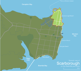
| Location |
| ||||||||||||||
| LGA(s) | Moreton Bay Region | ||||||||||||||
| Region | South East Queensland | ||||||||||||||
| State electorate(s) | Redcliffe | ||||||||||||||
| Federal Division(s) | Petrie | ||||||||||||||
| |||||||||||||||
Scarborough is a coastal residential suburb on the Redcliffe Peninsula in the north of the Brisbane metropolitan area in Queensland, Australia. It falls within the Moreton Bay Region local government area.[2] Along with its neighbouring coastal suburbs on the Redcliffe Peninsula, the suburb is a popular recreational destination within the Brisbane metropolitan area. Scarborough Beach is a safe swimming beach, with an adjacent playground.
Geography[]

Scarborough is at the northernmost of the Redcliffe peninsula, approximately 30 kilometres (19 mi) north-northeast of Brisbane, the state capital of Queensland, Australia.
History[]
Land sub-division occurred when Scarborough was part of Humpy Bong, Redcliffe. In August 1878 land in the new marine township of Scarborough went to auction, postponed some months until completion of the Scarborough Hotel, in order that perspective purchasers could obtain accommodation in the township while examining the allotments. Advertisements described the beach as "unsurpassed in Australia, having splendid stretches of pure hard sand, perfectly innocent of mud or mangrove. .... a distinctive feature at this northern or Scarborough end should be recognised in the highly interesting chain of crescent-shaped bays, the waters of which wash the township cliffs, affording sheltered coves for boating purposes...”[3][4]
In 1882, the proprietors of the re-surveyed town of Scarborough offered for auction, with no reserve, the remaining 250 allotments, advertising in great detail the attractions of the area. These included the "abundance of schnapper, whiting, turtle, crabs, oysters, etc awaiting capture."[5][6] In 1884, land from Queen's Beach "adjoins to and forms part of the property reserved for the Hon S.W. Griffith [Samuel Griffith] for the purpose of building a seaside residence" was advertised.[7][8] In 1886, land from " late marine residence of Dr Hobbs"- his house standing on three of the 295 allotments - was offered for sale.[9] Free steamer travel, departing from Howard Smith wharves was provided on the day, Easter Monday, 16 April 1886.[10]
In 1900–1901, allotments in the Moreton Bay Estate were advertised for sale.[11][12] In the 1920s, further sales, with land north of the Redcliffe Jetty [1920],[13] in the Walsh Estate [1927],[14] and the Sea Breeze Estate [1929][15] occurred, with Silvesters, a house and land agent at Adelaide Street, Brisbane, arranging sales into the 1930s, producing an annotated map showing the location of vacant land and the asking prices.[16][17] However, it was with the opening in 1935 of the Hornibrook Highway, linking the area north of Hay's Inlet to Brisbane, that lead to the rapid growth in this area.

The suburb used to act as a gateway to Moreton Island via the Combie Trader barge, but this service ceased in July 2008 due to matters with the terminal and landing areas.
In the 2011 census, Scarborough recorded a population of 7,986 people.[18]
Attractions and features[]
The main street of Scarborough, Landsborough Avenue, is a popular location for families and day visitors from Brisbane with numerous cafés. Part of the reason for its popularity is its overlooking views to Moreton Island across Moreton Bay, and quieter ambience compared to the Redcliffe central business district. The point of Scarborough is home to Scarborough Marina and Scarborough Holiday Village, while further around the bay is Newport Marina.[citation needed]
The suburb is known for its thriving seafood industry centred upon the Scarborough Boat Harbour. Scarborough Beach is one of a number of sandy beaches along its eastern coastline, with its Scarborough Beach Park awarded the "Queensland's Friendliest Beach" in 2003[19] and "Australia's Friendliest Beach" in 2004. The beach is safe for swimming and kayaking, and popular with fishers.[20]
Education[]
Educational institutions within the suburb of Scarborough are Scarborough State School with an enrolment of more than 860,[21] Southern Cross Catholic College's Scarborough primary (prep to 6), and De La Salle campuses (years 7 to 12). Part of the De La Salle campus has been converted into the Australian Technical College.
In popular culture[]
Parts of the movie Scooby-Doo were filmed at Queens Beach in Scarborough; the majority of the movie was filmed at Tangalooma Resort at Moreton Island.
Demographics[]
In the 2011 census, Scarborough recorded a population of 7,986 people, 52.3% female and 47.7% male.[18]
The median age of the Scarborough population was 45 years, 8 years above the national median of 37.
71.3% of people living in Scarborough were born in Australia. The other top responses for country of birth were England 8.3%, New Zealand 5.8%, Scotland 1.1%, South Africa 0.8%, Netherlands 0.8%.
90.5% of people spoke only English at home; the next most common languages were 0.6% German, 0.5% Dutch, 0.4% Russian, 0.4% French, 0.4% Italian.
Gallery[]
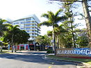
Entrance to Scarborough Central Business District, along Landsborough Avenue
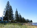
Scarborough Beach
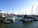
Scarborough Boat Harbour in the afternoon sun
References[]
- ^ Australian Bureau of Statistics (27 June 2017). "Scarborough (Qld) (State Suburb)". 2016 Census QuickStats. Retrieved 19 April 2018.

- ^ "Scarborough – suburb (entry 45496)". Queensland Place Names. Queensland Government. Retrieved 22 June 2017.
- ^ "Advertising". The Week (Brisbane). Queensland, Australia. 20 July 1878. p. 32. Retrieved 18 December 2019 – via Trove.
- ^ "The marine township of Scarborough, Parish of Redcliffe, Humpy Bong, Moreton Bay". 1878. hdl:10462/deriv/280194. Cite journal requires
|journal=(help) - ^ "Advertising". The Telegraph (3, 178). Queensland, Australia. 19 December 1882. p. 4. Retrieved 26 November 2019 – via National Library of Australia.
- ^ "Scarborough : Humpy Bong, Redcliffe". 1882. hdl:10462/deriv/451638. Cite journal requires
|journal=(help) - ^ "Classified Advertising". The Brisbane Courier. XXXVIII (8, 114). Queensland, Australia. 12 January 1884. p. 8. Retrieved 26 November 2019 – via National Library of Australia.
- ^ "Plan of Queen's Beach". 1884. hdl:10462/deriv/412004. Cite journal requires
|journal=(help) - ^ "Hobbs Homestead Estate Scarborough". 1886. hdl:10462/deriv/18513. Cite journal requires
|journal=(help) - ^ "Advertising". Toowoomba Chronicle And Darling Downs General Advertiser (3472). Queensland, Australia. 22 April 1886. p. 4. Retrieved 26 November 2019 – via National Library of Australia.
- ^ "Advertising". The Brisbane Courier. Queensland, Australia. 20 December 1900. p. 8. Retrieved 18 December 2019 – via Trove.
- ^ "Moreton Bay Estate, Scarborough, Parish of Redcliffe". 1900. hdl:10462/deriv/258851. Cite journal requires
|journal=(help) - ^ "Plan of subdivisions to north of Redcliffe Jetty, Redcliffe". 1920. hdl:10462/deriv/221024. Cite journal requires
|journal=(help) - ^ "Walsh Estate, Scarborough". 1927. hdl:10462/deriv/253899. Cite journal requires
|journal=(help) - ^ "Sea Breeze Estate, Scarborough". 1929. hdl:10462/deriv/253899. Cite journal requires
|journal=(help) - ^ "Advertising". The Brisbane Courier. Queensland, Australia. 7 January 1929. p. 22. Retrieved 18 December 2019 – via Trove.
- ^ "Plan of Scarborough, Redcliffe". hdl:10462/deriv/252460. Cite journal requires
|journal=(help) - ^ Jump up to: a b Australian Bureau of Statistics (31 October 2012). "Scarborough(State Suburb)". 2011 Census QuickStats. Retrieved 17 February 2017.
- ^ "Must-see Attractions". Redcliffe Tourism. Redcliffe City Council. Retrieved 27 July 2007.
- ^ "Scarborough Beach - Redcliffe". Visit Moreton Bay Region. Retrieved 30 July 2021.
- ^ "Scarborough State School (SS) : Primary Enrolments". Schools Directory. Queensland Government Department of Education, Training and the Arts. Retrieved 27 July 2007.
External links[]
Coordinates: 27°12′17″S 153°06′37″E / 27.2047°S 153.1102°E

| show Authority control |
|---|
- Suburbs of Moreton Bay Region
- 1971 establishments in Australia
- Populated places established in 1971
- Coastline of Queensland