Sekondi-Takoradi
Sekondi-Takoradi
City of Sekondi-Takoradi | |
|---|---|
City | |
 Top left picture: Arterial road and highway with the Sekondi-Takoradi Stadium, First top right picture: Shoreline of Sekondi-Takoradi, Second top right picture: Railway station of Sekondi-Takoradi, Bottom picture: Sekondi-Takoradi harbour with intermodal containers and private housing estates. | |
|
Logo of the City Metropolitan Assembly | |
 Sekondi-Takoradi Location of Sekondi-Takoradi in Western Region, Ghana | |
| Coordinates: 04°55′00″N 01°46′00″W / 4.91667°N 1.76667°W | |
| Country | Ghana |
| Admin. Region | Western Region |
| District | Sekondi Takoradi Metropolitan |
| Elevation | 10 m (30 ft) |
| Population (2012) | |
| • Total | 445,205[1] |
| Time zone | UTC+0 (GMT) |
| Postal codes | WS000-WS792 |
| Area code(s) | 031 |
| Website | www |


Sekondi-Takoradi is a city in Ghana comprising the twin cities of Sekondi and Takoradi.[2] It is the capital of Sekondi – Takoradi Metropolitan Assembly and the Western Region of Ghana. Sekondi-Takoradi is the region's largest city and an industrial and commercial centre, with a population of 445,205 people (2012).[1]

The chief industries in Sekondi-Takoradi are timber, cocoa processing, plywood, shipbuilding, its harbour and railway repair, and recently, sweet crude oil and crude oil. The fundamental job in Sekondi-Takoradi is fishing.[3] Sekondi-Takoradi lies on the main railway lines to Kumasi and Accra.
History[]

Sekondi an older and larger Ahanta town, was the site of Dutch Fort Orange (1642) and English Fort Sekondi (1682). It prospered from a railroad built in 1903 to hinterland mineral and timber resources. Takoradi also an Ahanta town was the site of Dutch Fort Witsen (1665) and has an important seaport, Ghana's first, built in 1928.[3][4] During World War II, RAF Takoradi was an important staging point for British aircraft destined for Egypt.[5] Spitfire fighter planes were shipped in crates from England to Takoradi where they were assembled then flown via Nigeria and Sudan to the war in Libya. 26 Squadron SAAF was also based in Takoradi during World War II flying anti-submarine and convoy protection patrols over the Atlantic. A number of South African airmen are buried in the Takoradi European Public cemetery.[6] The cities combined in 1946. On 20 November 1969, the city became the seat of the Roman Catholic Diocese of Sekondi–Takoradi.
The city is currently named (although not officially) as the Oil City of Ghana due to the massive discovery of oil in the Western region and has attracted massive migration from people all around the world.[7] For example, of the 248,680 people in the Sekondi-Takoradi metro area in 2010, 148,000, or well above half were indigenous Ahanta people, 30,000 came from the central region of Ghana, 60,000 are from other regions of Ghana and 10,000 are foreign nationals.[8]
Demographics[]
Sekondi-Takoradi's population is overwhelmingly Christian. 35% of the region are Pentecostal/Charismatic, 26% are Protestant and 14% are Catholic with the remaining 12% comprising numerous minor denominations. 9% of the population are Muslim, 3.5% identify as non religious and 0.2% practice traditional African religions The major ethnic group found in Sekondi are the Ahanta people.[9]
Economy[]
Takoradi houses the Harbour and has timber, energy and technology industries. Over the years it has attracted a good number of investors, including miners, as the city is close to the mining towns in the western part of Ghana.[4] Ghana's recent discovery of oil gave the Sekondi-Takoradi township to be known as the Oil City.
Tourist attractions[]
Sekondi-Takoradi has plenty of beaches, however they are not a major tourist attraction. Many of the beaches are found to the west of Takoradi, with small resorts such as Fanta's Folly, The Hideout, and Green Turtle Lodge with larger ones such as Busua Beach,[3] Lou Moon Lodge and Axim Beach Resort and also amazing places to eat such as Scoops Bar, Paragon Bar and Grill. It also has an annual street carnival, which is popular with tourists.[10] There is also the village of Nzulezu (village on water) which is a popular tourist site, in the Western Region.[11]
Education[]
Sekondi-Takoradi city has several secondary schools, colleges, and special schools, ranging from single-sex to coeducational institutions. Among the tertiary institutions are: Takoradi Technical University (a public institution), Nurses and Midwifery Training College, Holy Child Teachers Training College (now a College of Education).[12] The Sekondi-Takoradi city currently has several secondary schools and Special schools, ranging from single-sex to coeducational institutions. These include:

- Ghana Senior High Technical School (GSTS)
- [[List of schools in Ghana|St.
- (BBSTS)
Mary's boys senior high school]]
- Takoradi Secondary School (Tadisco)
- Methodist senior high school ( The Young legend)
- Sekondi College (Sekco)
- Ahantaman Senior High School
- Fijai Secondary School
- Adiembra Secondary School
- Bompeh senior high technical school
- Archbishop Porter Girls Secondary School and many others.[12]
Takoradi Technical Institute houses a fab lab, equipped by the Massachusetts Institute of Technology (MIT), which is the first of its kind in Africa.[12]
Takoradi has a well-equipped technical training centre (Takoradi Technical Institute, TTI, 1,400 students in two shifts) assisted by the German government through GTZ/GOPA. Apart from TTI, Takoradi has a polytechnic and other renowned secondary schools including Ghana Secondary Technical School, St. Mary Secondary School, Bompeh Secondary School, Takoradi Secondary School and many others. Sekondi-Takoradi has many internet cafés and computer training centres to encourage familiarity with computers and acquire computer skills.
The Western Regional Library was established in Sekondi in 1955.[13]
Stadiums and sports[]

Stadiums[]
- Essipong Stadium
- Gyandu Park
Sports[]
Professional sports teams based in Sekondi-Takoradi include:
Climate[]
Sekondi-Takoradi has a tropical savanna climate (Köppen climate classification: Aw).
| hideClimate data for Sekondi-Takoradi | |||||||||||||
|---|---|---|---|---|---|---|---|---|---|---|---|---|---|
| Month | Jan | Feb | Mar | Apr | May | Jun | Jul | Aug | Sep | Oct | Nov | Dec | Year |
| Record high °C (°F) | 35.0 (95.0) |
35.5 (95.9) |
35.0 (95.0) |
34.6 (94.3) |
34.6 (94.3) |
32.3 (90.1) |
31.8 (89.2) |
30.4 (86.7) |
31.2 (88.2) |
32.0 (89.6) |
34.5 (94.1) |
34.2 (93.6) |
35.5 (95.9) |
| Average high °C (°F) | 30.4 (86.7) |
31.0 (87.8) |
31.3 (88.3) |
31.1 (88.0) |
30.2 (86.4) |
28.4 (83.1) |
27.3 (81.1) |
26.8 (80.2) |
27.6 (81.7) |
28.8 (83.8) |
30.0 (86.0) |
30.3 (86.5) |
29.4 (84.9) |
| Daily mean °C (°F) | 26.2 (79.2) |
26.9 (80.4) |
27.2 (81.0) |
27.2 (81.0) |
26.7 (80.1) |
25.6 (78.1) |
24.8 (76.6) |
24.1 (75.4) |
24.6 (76.3) |
25.5 (77.9) |
26.2 (79.2) |
26.2 (79.2) |
26.0 (78.8) |
| Average low °C (°F) | 21.8 (71.2) |
22.6 (72.7) |
23.1 (73.6) |
23.2 (73.8) |
23.1 (73.6) |
22.8 (73.0) |
21.8 (71.2) |
21.1 (70.0) |
21.7 (71.1) |
22.1 (71.8) |
22.2 (72.0) |
22.1 (71.8) |
22.3 (72.1) |
| Record low °C (°F) | 16.1 (61.0) |
18.3 (64.9) |
20.6 (69.1) |
20.6 (69.1) |
20.0 (68.0) |
19.4 (66.9) |
17.2 (63.0) |
16.1 (61.0) |
17.8 (64.0) |
18.9 (66.0) |
18.9 (66.0) |
16.1 (61.0) |
16.1 (61.0) |
| Average rainfall mm (inches) | 31 (1.2) |
35 (1.4) |
79 (3.1) |
115 (4.5) |
250 (9.8) |
346 (13.6) |
120 (4.7) |
43 (1.7) |
57 (2.2) |
138 (5.4) |
77 (3.0) |
31 (1.2) |
1,322 (51.8) |
| Average rainy days (≥ 0.3 mm) | 3 | 4 | 7 | 10 | 17 | 19 | 13 | 11 | 13 | 14 | 10 | 5 | 126 |
| Average relative humidity (%) | 86 | 85 | 83 | 84 | 84 | 86 | 87 | 87 | 87 | 87 | 86 | 85 | 86 |
| Mean monthly sunshine hours | 207.7 | 209.1 | 229.4 | 216.0 | 192.2 | 132.0 | 148.8 | 133.3 | 126.0 | 195.3 | 243.0 | 229.4 | 2,262.2 |
| Mean daily sunshine hours | 6.7 | 7.4 | 7.4 | 7.2 | 6.2 | 4.4 | 4.8 | 4.3 | 4.2 | 6.3 | 8.1 | 7.4 | 6.2 |
| Source: Deutscher Wetterdienst[14] | |||||||||||||
Sister cities[]
Gallery[]

Virgin Island in Sekondi-Takoradi.

Beach on Virgin Island in Sekondi-Takoradi.
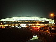
Sekondi-Takoradi Stadium at night.

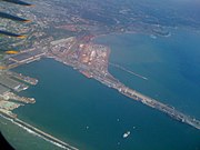
Aerial view of the Sekondi-Takoradi Shores.
Highway in Sekondi-Takoradi.

Commuters on street in Sekondi-Takoradi.

Takoradi Airport (Sekondi-Takoradi Airport).


See also[]
- Takoradi Airport
- Takoradi Harbour
- Market Circle, Takoradi
- Railway stations in Ghana
| Wikimedia Commons has media related to Sekondi-Takoradi. |
References[]
- ^ Jump up to: a b "World Gazetteer online". World-gazetteer.com. Archived from the original on 30 September 2007. Retrieved 8 February 2014.
- ^ "Betway extends support to Volleyball Teams in the Western and Western North Regions". Citi Sports Online. 21 May 2021. Retrieved 21 May 2021.
- ^ Jump up to: a b c "Private Tutor". Infoplease.com. Retrieved 8 February 2014.
- ^ Jump up to: a b "Takoradi Port", Ghana Ports and Harbour Authority. Archived 31 December 2007 at the Wayback Machine
- ^ Nancy Lawler (2002). "Soldiers, Airmen, Spies, and Whisperers: The Gold Coast in World War II". Ohio University Press. ISBN 9780821414309. Retrieved 8 February 2014 – via BiblioVault.
- ^ "South Africa War Graves Project". Southafricawargraves.org. 8 October 2011. Retrieved 8 February 2014.
- ^ Obeng-Odoom F., 2014, Oiling the Urban Economy: Land, Labour, Capital, and the State in Sekondi-Takoradi, Ghana, Routledge, London.
- ^ Stats Ghana report on Sekondi-Takoradi population
- ^ Ghana Statistical Service report on Sekondi-Takoradi
- ^ "Sekondi-Takoradi Masqueraders Street Carnival". CNN iReport. Retrieved 2 September 2016.
- ^ Darko, Kwaku. "30 magical pictures of Nzulezu that will make you want to visit". OMGVoice. Retrieved 19 April 2018.
- ^ Jump up to: a b c [1] Archived 25 March 2012 at the Wayback Machine
- ^ World Guide to Libraries (25th ed.), De Gruyter Saur, 2011, ISBN 9783110230710
- ^ "Klimatafel von Takoradi (Sekondi-Takoradi) / Ghana" (PDF). Baseline climate means (1961-1990) from stations all over the world (in German). Deutscher Wetterdienst. Retrieved 18 October 2016.
Afrosages.com, Tourist Destinations Of Western Ghana, January 13, 2020
External links[]
- Mytakoradi.com
- Ghana-pedia webpage – Takoradi
 Media related to Sekondi-Takoradi at Wikimedia Commons


| Authority control |
|
|---|
- Sekondi-Takoradi
- Populated places in the Western Region (Ghana)
- Regional capitals in Ghana