Tarkwa
Tarkwa | |
|---|---|
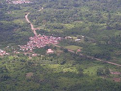 | |
 Tarkwa Location of Tarkwa in Western region, South Ghana | |
| Coordinates: 05°18′00″N 01°59′00″W / 5.30000°N 1.98333°WCoordinates: 05°18′00″N 01°59′00″W / 5.30000°N 1.98333°W | |
| Country | |
| Region | |
| District | Tarkwa-Nsuaem Municipal |
| Population (2013) | |
| • Total | 34,941[1] |
| Time zone | GMT |
| • Summer (DST) | GMT |


Tarkwa is a town and is the capital of Tarkwa-Nsuaem Municipal district, a district in the Western Region southwest of South Ghana.[6][7] Tarkwa has a 2013 settlement population of 34,941 people.[1]
Economy[]
Mining[]
Tarkwa is noted as a centre of gold mining and manganese mining. Tarkwa Mine, which is a large open-cast gold mine, is situated to the northwest of the town, and Nsuta manganese mine is situated to the east of the town. Tarkwa Mine mines several low-grade conglomeratic "reefs" of Tarkwaian type.[6] These reefs are of mid-Proterozoic age.
A number of mining companies cluster between the villages of Aboso and in the late 19th century.[8]
Tarkwa Mine has the distinction of being one of the largest gold mines in South Ghana. Approximately 24 tons of gold is produced annually, and 100 million tons of earth is moved to achieve this production rate. The Iduapriem Gold Mine is also located near Tarkwa, 10 km south of the town.[9] The Tarkwa Goldfield was discovered a few years before the Witwatersrand Goldfield in South Africa.
Climate[]
| Climate data for Tarkwa | |||||||||||||
|---|---|---|---|---|---|---|---|---|---|---|---|---|---|
| Month | Jan | Feb | Mar | Apr | May | Jun | Jul | Aug | Sep | Oct | Nov | Dec | Year |
| Average high °C (°F) | 32 (89) |
32 (90) |
32 (90) |
31 (87) |
32 (89) |
30 (86) |
27 (80) |
27 (80) |
29 (84) |
30 (86) |
31 (87) |
30 (86) |
32 (90) |
| Average low °C (°F) | 24 (75) |
25 (77) |
25 (77) |
25 (77) |
25 (77) |
24 (75) |
23 (73) |
22 (71) |
22 (72) |
24 (75) |
24 (76) |
23 (74) |
22 (72) |
| Average precipitation mm (inches) | 25 (1.0) |
25 (1.0) |
100 (4.0) |
130 (5.0) |
200 (8.0) |
330 (13.0) |
100 (4.0) |
25 (1.0) |
51 (2.0) |
150 (6.0) |
130 (5.0) |
51 (2.0) |
1,320 (52.0) |
| Source: Myweather2.com[10] | |||||||||||||
Education[]
High Schools[]
Tarkwa Senior High School (TARSCO) and (FIASEC) are located in Tarkwa
University[]
University of Mines and Technology (UMaT), is located in Tarkwa.
Transport[]
Train[]
Tarkwa is a junction railway station and is served by Tarkwa Train Station on the Ghana Railway Corporation.
See also[]
References[]
- ^ a b "World Gazetteer online". World-gazetteer.com. Archived from the original on September 30, 2007.
- ^ Wright, J.B.; Hastings, D.A.; Jones, W.B.; Williams, H.R. (1985). Wright, J.B. (ed.). Geology and Mineral Resources of West Africa. London: George Allen & UNWIN. pp. 45–47. ISBN 9780045560011.
- ^ Taylor, Ryan; Anderson, Eric (2018). Quartz-Pebble-Conglomerate Gold Deposits, Chapter P of Mineral Deposit Models for Resource Assessment, USGS Scientific Investigations Report 2010-5070-P (PDF). Reston: US Dept. of the Interior, USGS. p. 9.
- ^ Meredith, Martin (2014). The Fortunes of Africa. New York: Public Affairs. p. 71,75. ISBN 9781610396356.
- ^ Shillington, Kevin (2012). History of Africa. London: Palgrave Macmillan. pp. 89, 93–94, 97, 101–102, 105, 110. ISBN 9780230308473.
- ^ a b Tarkwa-Nsuaem Municipal District
- ^ Amoh, Emmanuel Kwame (2022-01-23). "Maxam's suspension will affect mining in Ghana - AGA Snr Manager". 3NEWS. Retrieved 2022-01-24.
- ^ Dickson, Kwamina B. (1969). A Historical Geography of Ghana. CUP Archive. p. 183. ISBN 9780521071024.
- ^ Country report: Ghana - Iduapriem AngloGold Ashanti website, accessed: 10 August 2010
- ^ "Tarkwa Weather Averages". Myweather2. 2013. Retrieved 22 June 2013.

...
- Populated places in the Western Region (Ghana)