Shadwell Basin
| Shadwell Basin | |
|---|---|
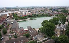 | |
 Shadwell Basin 2006 | |
 Shadwell Basin Location within Greater London | |
| OS grid reference | TQ351806 |
| London borough | |
| Ceremonial county | Greater London |
| Region | |
| Country | England |
| Sovereign state | United Kingdom |
| Post town | LONDON |
| Police | Metropolitan |
| Fire | London |
| Ambulance | London |
| UK Parliament | |
| London Assembly | |

Shadwell Basin is a housing and leisure complex built around a disused dock in Wapping, London. The old dock was formerly part of the London Docks, a group of docks built by the London Dock Company at Wapping as part of the wider docks of the Port of London, and historically in Shadwell from where it takes its name.
Today Shadwell Basin is one of the most significant bodies of water surviving from the historical London Docks. It is situated on the north side of the river Thames east (downstream) of the Tower of London and Tower Bridge and west (upstream) of Limehouse.
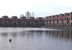
Unlike some of the London Docks which have been landfilled, Shadwell Basin, the most easterly part of the complex, has been retained. It is now a maritime square of 2.8 hectares used for recreational purposes (including sailing, canoeing and fishing) and is surrounded on three sides by a waterside housing development designed by British architects MacCormac, Jamieson, Prichard and Wright.
The residential buildings are four and five storeys with façades of alternating open arches and enclosed structure, echoing the scale of traditional 19th century dockside warehouses, with a colonnade at quayside. The development, made up of Newlands Quay, Maynards Quay and Peartree Lane, was added to the National Heritage List for England by Historic England as Grade II listed in 2018, part of a first-ever listing of Post-Modern buildings.[1][2]
Shadwell Basin has Benson Quay on its south-west corner with its south side overlooked by Riverside Mansions in Milk Yard and the Monza Building in Monza Street and, at its south-eastern end, the former Wapping Hydraulic Power Station building.
On the north side of Shadwell Basin, east of Newlands Quay, St. Paul's Church, Shadwell provides a dramatic backdrop with its spire and the St Paul's Church Conservation Area extends to the water's edge with a terraced quayside that includes an outdoor gym.
Shadwell Basin is a popular public route for cyclists, joggers and pedestrians with a walkway alongside the water as part of the linked open spaces and canals between the river and Hermitage Basin near St Katharine Docks to the west.
History[]
The London Docks expanded eastward in the 1830s with the opening of the Eastern Dock and Shadwell Basin (built 1828–32). To provide these new docks with access to the river, a new entrance at Shadwell was built. Opened in 1832, it was named Shadwell Entrance (the main entrance to the London Dock was through Wapping Entrance with a third entrance at Hermitage Basin).
By the 1850s, the London Dock Company had recognised that the entrances at both Wapping and Shadwell were too small to accommodate the newer and larger ships coming into service. In 1854-58 the company built a new larger entrance (45 feet wide) and a new basin at Shadwell (the only element of the London Docks system to have survived redevelopment to this day) linked to the west part of the docks by Eastern Dock and the short Tobacco Dock.
Even by the start of the 20th century the docks in Wapping had become outdated as steam power meant ships were built too large to fit into them. Cargoes were unloaded downriver and then ferried by barge to warehouses in Wapping. This system was uneconomic and inefficient and one of the main reasons that the docks in Wapping were the first to close in the 1960s.
The London docks complex closed to shipping in 1969. Purchased by the London Borough of Tower Hamlets, Shadwell Basin and the western part of the London Docks fell into a derelict state,[3] mostly a large open tract of land and water. Acquired in 1981 by the London Docklands Development Corporation (LDDC), redevelopment of Shadwell Basin took place in 1987 resulting in 169 houses and flats being built around the retained historic dock.
Landmarks[]
(North)
- St. Paul's Church, Shadwell — the Church of Sea Captains
(South)
- The former Wapping Hydraulic Power Station building (previously the site of the Wapping Project arts venue and Wapping Food restaurant).
- Prospect of Whitby
(East)
- King Edward VII Memorial Park — giving access to the River Thames
- The Shadwell Basin Outdoor Activity Centre - including Tower Hamlets Canoe Club and Docklands Dive School
People[]
People associated with the area:
- Captain James Cook (1728–1779) lived in the area, and baptised some of his children at St. Paul's Church, Shadwell
- Jane Randolph Jefferson (1720–1776), mother of President of the United States Thomas Jefferson, was born in Shakespeare Walk (a road which ran from north to south in the middle of what is now Shadwell Basin) and was baptised at St. Paul's Church, Shadwell
- John Wesley (1703–1791) preached at St. Paul's Church, Shadwell
- Sir William Henry Perkin (1838–1907) chemist who discovered aniline purple dye was baptised at St. Paul's Church, Shadwell
Neighbouring streets[]
North of Shadwell Basin
- Newlands Quay — formerly Elbow Lane (in 1862)
East of Shadwell Basin
- Pear Tree Lane — formerly Fox's Lane (in 1862). Named after The Pear Tree, the inn where the second group of Ratcliff Highway murders took place.
West of Shadwell Basin
- Maynards Quay off Garnet Street — formerly New Gravel Lane (in 1862)
- Benson Quay
South of Shadwell Basin starting from the west:
- Milk Yard
- Monza Street
- Wapping Wall
References & links[]
- ^ Historic England. "Shadwell Basin Housing, 5–54 (cons) Maynards Quay, 1–62 (cons) Newlands Quay and 1–35 (odd) Peartree Lane (1451936)". National Heritage List for England. Retrieved 22 December 2020.
- ^ 1980s Buildings Officially Become Heritage
- ^ "Wapping 13 Oct 1973: Shadwell dock basin & lock gate". Flickr.
| Wikimedia Commons has media related to Shadwell Basin. |

- Geography of the London Borough of Tower Hamlets
- London docks
- Port of London
- Shadwell
- Wapping