Shapotou District
Shapotou
沙坡头区 شَاپُوَتِوْ ٿِيُوِ | |
|---|---|
 Shapotou theme park | |
 Shapotou in Zhongwei | |
 Zhongwei in Ningxia | |
| Coordinates: 37°31′01″N 105°10′26″E / 37.5169°N 105.1738°ECoordinates: 37°31′01″N 105°10′26″E / 37.5169°N 105.1738°E | |
| Country | People's Republic of China |
| Autonomous region | Ningxia |
| Prefecture-level city | Zhongwei |
| Area | |
| • Total | 5,380.42 km2 (2,077.39 sq mi) |
| Population | |
| • Total | 378,606 |
| • Density | 70/km2 (180/sq mi) |
| Time zone | UTC+8 (China Standard) |

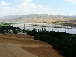
Shapotou District (simplified Chinese: 沙坡头区; traditional Chinese: 沙坡頭區; pinyin: Shāpōtóu Qū, Xiao'erjing: شَاپُوَتِوْ ٿِيُوِ) is a district of Zhongwei, Ningxia, China, noted for the Tengger Desert, and bordering Inner Mongolia to the north and Gansu province to the west.
It is the site of the . The research station is located at the southern end of the dune sea on the banks of the Yellow River. Research at station includes dune stabilization using grasses and microbial mats. Regions stabilized in the 1950s are now used for fruit and vine crops.
Sand dune stabilization in the region is required to curtail burial of the trans-Asia Baotou–Lanzhou Railway.
Administrative divisions[]
In the present, Shapotou District, has 10 towns and 1 township.
- 10 towns
- (滨河镇, بٍحَ جٍ)
- Wenchang (文昌镇, وٌچَانْ جٍ)
- Dongyuan (东园镇, دْويُوًا جٍ)
- Rouyuan (柔远镇, ژِوْيُوًاجٍ)
- (镇罗镇, جٍلُوَ جٍ)
- He (和镇, حَ جٍ)
- (永康镇, يٌکَانْ جٍ)
- Changle (常乐镇, چَانْلَ جٍ)
- (迎水桥镇, يٍشُوِٿِيَوْ جٍ)
- Xingren (兴仁镇, ثٍْژٍ جٍ)
- 1 township
- Xiangshan (香山乡, ثِيَانْشًا ثِيَانْ)
External links[]
| show Authority control |
|---|
This Ningxia location article is a stub. You can help Wikipedia by . |
- Deserts of China
- County-level divisions of Ningxia
- Dunes of China
- Northwestern China geography stubs