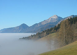
Slovenian Mountain Hiking Trail
The Slovenian Mountain Hiking Trail (Slovene: Slovenska planinska pot), sometimes also called Transverzala (Long-Distance Trail), is a route from Maribor to Ankaran. It covers most of the Slovenian mountain areas including Pohorje, the Julian Alps, the Kamnik-Savinja Alps, the Karawanks, and the southwestern part of Slovenia. It is the oldest hiking track in Europe.[1]
History[]
The idea of connecting the most beautiful, hilly, and mountainous area in Slovenia came from in 1950. Originally, the trail was meant to be a circular route, which would start and end in Maribor. It was later changed to include Postojna and other areas towards the sea. It mostly included existing hiking trails. However, on some shorter parts it was necessary to make new demarcations to connect them together.
The trail opened on August 1, 1953, with 80 control points. Since then, the trail has only changed slightly. These are the trail's current features: Control points: 75; Length: 599 km; Total ascent: 45.2 km; Total descent: 45.5 km.
There are 58 huts and two museums — the Slovene Alpine Museum in Mojstrana, and Franja Partisan Hospital (from World War II) — and the cave system named Škocjan Caves.
The first guided tour of Slovenski planinski transverzali was conducted in 1958. About 9500 hikers have completed the route over 60 years of the trail's history.
The Slovenian Mountain Hiking Trail also has an extended route with 35 control points throughout Slovenia.
Route[]
It is possible to start in Maribor, Ankaran, or anywhere else on the circular route. Hikers must obtain a book from the Alpine Association of Slovenia in which they will be able to collect stamps that are located on mountain tops or huts along the way. If no stamp is available, a photo also counts. The hiking is not time limited.
The route consists mainly of easy trails, but there are also some more challenging ones.
Pohorje and northeastern area[]
The control points of the trail on Pohorje Plateau and in the northeastern Slovenia are:
- Maribor Lodge (Mariborska koča; 1068 m)
- Ruše Lodge (Ruška koča) near Areh (1246 m); (1030 m)
- (Koča na Klopnem vrhu; 1280 m)
- (Koča na Pesku; 1386 m);
- Ribnica Lodge (Ribniška koča; 1507 m); Black Peak (Črni vrh; 1543 m)
- (1371 m)
- (Koča pod Kremžarjevim vrhom; 1102 m); Slovenj Gradec
- (Poštarska koča pod Plešivcem; 805 m)
- (Dom na Uršlji gori; 1670 m)
- (Andrejev dom na Slemenu; 1096 m)
Kamnik–Savinja Alps[]
The control points of the trail in the Kamnik–Savinja Alps (northern Slovenia) are:
- Smrekovec Lodge (Dom na Smrekovcu; 1377 m); Koča na Travniku (1548 m)
- Loka Lodge at Raduha (Koča na Loki pod Raduho; 1520 m)
- Big Mount Raduha (2062 m)
- (Koča na Grohatu pod Raduho; 1460 m); Rogovilc Inn (Gostišče Rogovilc; 610 m)
- Kocbek Lodge at Korošica (Kocbekov dom na Korošici; 1808 m)
- Ojstrica (2350 m)
- Kamnik Saddle Lodge (Koča na Kamniškem sedlu; (1864 m)
- (Turska gora; 2251 m)
- Skuta (2532 m)
- Zois Lodge at Kokra Saddle (Cojzova koča na Kokrskem sedlu; 1793 m)
- Grintovec (2558 m)
- Kočna (2540 m)
- Czech Lodge at Spodnje Ravni (Češka koča na Spodnjih Ravneh; 1543 m); Jezersko (880 m)
- (Planinski dom na Kališču; 1534 m)
- Storžič (2132 m)
- Storžič Lodge (Dom pod Storžičem; 1123 m); Fat Peak (Tolsti vrh; 1715 m)
- (Koča na Kriški gori; 1471 m); Tržič (515 m)
- (Koča na Dobrči; 1478 m); Preval (1311 m)
Karawanks[]

The control points of the trail in the Kamnik–Savinja Alps (northern Slovenia) are:
- Begunjščica (2060 m)
- (Roblekov dom na Begunjščici; 1657 m)
- (Planinski dom na Zelenici; 1536 m)
- Prešeren Lodge at Stol (Prešernova koča na Stolu; 2174 m); (Koča na Golici; 1582 m)
- Golica (1836 m)
Julian Alps[]

The control points of the trail in the Kamnik–Savinja Alps (northern Slovenia) are:
- Slovenian Alpine Museum (641 m); Mojstrana (641 m)
- Aljaž Lodge in the Vrata Valley (Aljažev dom v Vratih; 1015 m)
- (Dom Valentina Staniča; 2332 m) below Triglav
- Triglav Lodge at Kredarica (Triglavski dom na Kredarici; 2515 m)
- Triglav (2864 m)
- or Planika Lodge at Triglav (Dom Planika pod Triglavom; 2404 m) or (Tržaška koča na Doliču; 2151 m); (Luknja; 1758 m); (Bovški Gamsovec; 2392 m)
- (Pogačnikov dom na Kriških podih; 2052 m)
- Razor (2601 m)
- Prisojnik (2547 m)
- Vršič Pass — (Poštarski dom na Vršiču; 1688 m) or (Tičarjev dom na Vršiču; 1620 m) or (Erjavčeva koča na Vršiču; 1515 m)
- (Zavetišče pod Špičkom; 2064 m)
- Jalovec (2645 m)
- (Koča pri izviru Soče; 886 m)
- (Zasavska koča na Prehodavcih; 2071 m)
- Triglav Lakes Lodge (Koča pri Triglavskih jezerih; 1685 m)
- Komna — (Dom na Komni; 1520 m) or (Koča pod Bogatinom; 1513 m)
- (Planinski dom pri Krnskih jezerih; 1385 m)
- (Gomiščkovo zavetišče na Krnu; 2182 m)
- (Koča na planini Razor; 1315 m)
- Vogel (1922 m)
- (1966 m)
- (Dom Zorka Jelinčiča na Črni prsti; 1835 m); Petrovo Brdo (803 m)
- (Dom Andreja Žvana-Borisa na Poreznu; 1590 m)
- Franja Partisan Hospital (Partizanska bolnica Franja; 536 m)

Southwestern area[]

The control points of the trail in southwestern Slovenia are:
- (Planinska koča na Ermanovcu; 964 m)
- (Bevkov vrh; 1051 m)
- — (Mrzli vrh; 1008 m); Idrija (325 m)
- (Koča na Hleviški planini; 818 m): Vojsko (1077m)
- (Mali Golak; 1495 m); (Iztokova koča pod Golaki; 1260 m)
- (Koča Antona Bavčerja na Čavnu; 1242 m)
- (Sinji vrh; 1002 m); Col (619 m)
- (Pirnatova koča na Javorniku; 1156 m); Podkraj (797 m)
- (Furlanovo zavetišče pri Abramu; 900 m)
- (Vojkova koča na Nanosu; 1201 m); Razdrto (577 m); Senožeče (580 m)
- (1026 m);
- Matavun — Škocjan Caves (Škocjanske jame; 393 m); Artviže (817 m); Markovščina (567 m)
- (Tumova koča na Slavniku; 1028 m); Prešnica (480 m)
- Socerb (389 m)
- Tinjan (374 m)
- Ankaran (19 m)
Old control points[]
- Frischauf Lodge at Okrešelj (Frischaufov dom na Okrešlju; 1396 m)
- (Kranjska koča na Ledinah; 1700 m)
- Koroška Rinka (2433 m)
- (Valvasorjev dom pod Stolom; 1180 m)
- (Dom Pristava v Javorniškem Rovtu; 930 m)
- (Dom pod Golico; 933 m)
- (Planinski dom »Rudar« na Vojskem; 1080 m)
- Predjama (503 m)
- (1106 m)
Extended Slovenian Mountain Hiking Trail[]

The Extended Slovenian Mountain Hiking Trail was created in 1966 to include mountains that are dispersed all over the country and are not connected. Until 1993 it had 18 mandatory and 20 non-mandatory control points. (10 of them are over 1000 m high). Then it was enhanced to 35 obligatory control points and one hill.
- Julian Alps
- (Stol; 1673 m)
- (Visoki Kanin; 2587 m) or (2208 m)
- Mangart (2678 m)
- (Bavški Grintavec; 2347 m)
- Škrlatica (2740 m) or Špik (2472 m)
- (2014 m)
- Ratitovec — (Krekova koča na Ratitovcu; 1642 m)
- Karawanks
- (Veliki vrh; 2088 m)
- Olševa (1929 m)
- Peca — (Kordeževa glava; 2125 m)
- Kamnik–Savinja Alps
- Cold Mountain (Mrzla gora; 2203 m), non-mandatory
- Menina Pasture — (Dom na Menini planini; 1453 m)
- Northeastern Slovenia

- (Paški Kozjak) — (Dom na Paškem Kozjaku; 960 m)
- (1522 m)
- (Žavcarjev vrh) — (Koča na Žavcarjevem vrhu; 863 m)
- (Zavrh v Slovenskih goricah; 370 m)
- Jeruzalem, Ljutomer (338 m)
- Selo, Moravske Toplice (295 m)
- Mount Saint Donatus (Donačka gora; 882 m)
- Boč (979 m)
- — (Koča na Bohorju; 898 m) or Lisca — (Tončkov dom; 927 m)
- — (Planinski dom na Resevni; 645 m)
- — (Planinski dom na Mrzlici; 1093 m) or Kum — (Planinski dom na Kumu; 1211 m)
- Geometric Centre of the Republic of Slovenia – GEOSS (645 m)

- Gradišče — (Lavričeva koča na Gradišču; 510 m)
- (Mala gora) — (Planinska koča pri Sv. Ani na Mali gori; 910 m)
- Gorjanci — Trdina Peak (Trdinov vrh; 1178 m)
- Mount Mirna (Mirna gora) — (Planinski dom na Mirni gori; 1000 m)
- (Veliki Snežnik) — (Koča Draga Karolina na Velikem Snežniku; 1796 m)
- Slivnica — (Dom na Slivnici; 1075 m)
- Krim — (Planinska koča na Krimu; 1107 m)
- Grmada (898 m)
- Lubnik — (Dom na Lubniku; 1025 m)
- Littoral
- Matajur (1642 m)
- — (Planinsko zavetišče na Koradi; 803 m)
- — (Stjenkova koča na Trstelju; 610 m)
See also[]
References[]
- ^ "Hiking in Slovenia". Www.via-alpina.org. Retrieved 14 February 2015.
External links[]
 Media related to Slovenian Mountain Hiking Trail at Wikimedia Commons
| Authority control |
|---|
- 1953 establishments in Slovenia
- Hiking trails in Slovenia
- Mountaineering in Slovenia