South Croydon
This article needs additional citations for verification. (July 2010) |
| South Croydon | |
|---|---|
 South End, South Croydon | |
 South Croydon Location within Greater London | |
| Population | 15,790 (South Croydon ward) |
| OS grid reference | TQ325633 |
| London borough | |
| Ceremonial county | Greater London |
| Region | |
| Country | England |
| Sovereign state | United Kingdom |
| Post town | SOUTH CROYDON |
| Postcode district | CR2 |
| Dialling code | 020 |
| Police | Metropolitan |
| Fire | London |
| Ambulance | London |
| UK Parliament | |
| London Assembly | |

South Croydon in south London is the area surrounding the valley south of central Croydon and running as far south as the former Red Deer public house on the Brighton Road. It is bounded by Waddon to the West and Selsdon and Sanderstead to the East. It is part of the South Croydon (CR2) post town and in the London Borough of Croydon. It is essentially a dormitory suburb for Croydon and London.
Toponymy[]
The placename Croydon is recorded as early as 809 and is listed in the 1086 Domesday Book.[1] South Croydon as a distinct area is found much later, in the 19th century, when the area was developed as a residential suburb.[1]
Government[]
The area is largely covered by the South Croydon ward of Croydon Council, which elected 3 Conservatives in the last local elections in May 2018. Parts of the area are also in Fairfield ward, which elected 3 Labour Councillors in May 2018.
The area is split between the Parliamentary Constituencies of Croydon Central and Croydon South, with the area near South End located in Croydon Central, and the rest of the area located in Croydon South.
Geography[]
The area is bounded by the South Croydon electoral ward of the London Borough of Croydon. To the west and south it is bounded by the historic Croydon parish boundary, which runs from Conduit Lane to Croham Hurst, crossing Croham Road where it becomes Croham Valley Road, then across to the railway line, crossing Selsdon Road where it becomes Upper Selsdon Road and crossing Carlton Road where it becomes Mayfield Road. Thereafter the old parish boundary roughly follows the railway south as far as the Red Deer public house, beyond which lies Purley Oaks. Curiously, Purley Oaks Primary School lies on the South Croydon side of the boundary and not in Purley Oaks.[2]
Landmarks of South Croydon include:
- Croham Hurst
- The former Swan and Sugarloaf public house, now a branch of Tesco Express.
- The former Red Deer public house, now a Polish Supermarket
- Whitgift School
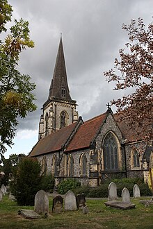
- St Peter's Church (designed by George Gilbert Scott)
- St Augustine's Church
- South Croydon Bus Garage
- 46 South End
Green space is provided to the west by the enormous Purley Way Playing Fields, and the hidden green space with gardens that is Haling Grove sandwiched between Pampisford Road and the A23: the extensive Whitgift School playing fields frequently host international cricket and rugby matches.
The postal district of South Croydon includes Sanderstead, Selsdon and two remnants of Addington, Croham Valley and Monks Hill. It has the following schools: Harris Academy Purley (formerly Haling Manor High School), Regina Coeli Catholic Primary School, St Peter's Primary School, St Giles School (specialist disabled school), Ridgeway Primary School, Gresham Primary School, Purley Oaks Primary School, Howard Primary School, Atwood Primary School, Selsdon Primary and Nursery School, Greenvale Primary School, Gilbert Scott Primary School, Whitgift School and The Quest Academy.
Conservation Area[]
The Croham Manor Road Conservation Area lies in South Croydon, running from the junction with the Selsdon Road along the West side of Croham Hurst. The area is notable for its distinctive and planned 1930s architecture.[3]
Nearest places[]
- Croydon (town)
- Coombe
- Selsdon
- Sanderstead
- Riddlesdown
- Kenley
- Purley
- Purley Way
- Croydon Airport
- Waddon
Transport[]
Nearest railway stations[]
- South Croydon
- Purley Oaks
- Sanderstead
- Riddlesdown
- Selsdon Road – closed
- Spencer Road halt – closed
- Coombe Road railway station – closed
Tramlink[]
References[]
- ^ a b Mills, D. (2000). Oxford Dictionary of London Place Names. Oxford.
- ^ "Why Croydon's new ward boundaries look rather close to the Conservative proposal". The Croydon Citizen. 23 March 2017. Retrieved 1 December 2019.
- ^ "Croham Manor Road Conservation Area - Appraisal and Management Plan" (PDF). Croydon Council. Retrieved 1 December 2019.
External links[]
- Whitgift School
- The Woodside & South Croydon Railway - describes Selsdon Road Station and Spencer Road Halt

- Districts of the London Borough of Croydon
- Areas of London