South Croydon railway station
This article needs additional citations for verification. (January 2009) |
| South Croydon | |
|---|---|
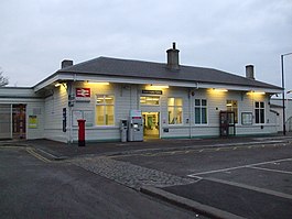 | |
 South Croydon Location of South Croydon in Greater London | |
| Location | South Croydon |
| Local authority | London Borough of Croydon |
| Managed by | Southern |
| Station code | SCY |
| DfT category | D |
| Number of platforms | 5 (2 in use; 3 at peak times) |
| Fare zone | 5 |
| National Rail annual entry and exit | |
| 2016–17 | |
| 2017–18 | |
| 2018–19 | |
| 2019–20 | |
| 2020–21 | |
| Key dates | |
| 1 September 1865 | Opened |
| Other information | |
| External links | |
| WGS84 | 51°21′46.4″N 0°5′37.2″W / 51.362889°N 0.093667°WCoordinates: 51°21′46.4″N 0°5′37.2″W / 51.362889°N 0.093667°W |

South Croydon railway station is in the London Borough of Croydon in south London, in Travelcard Zone 5. It is on the Brighton Line at its junction with the Oxted Line, 11 miles 21 chains (18.1 km) measured from London Bridge.[2]
The station is managed by Southern, and the station is served by both Southern and Thameslink services.
History[]
Originally South Croydon was a terminus next to the through lines of the Brighton Line but without any platforms on them, the end of a 1 mile (1.6 km) extension of the local lines from New Croydon, opened by the London Brighton and South Coast Railway on 1 September 1865. The aim was to provide more space for reversing local trains than could be afforded at busy New Croydon. The rapid growth of the town in this area may also have been a factor.[3]
In 1894 the railway obtained authority to extend the local lines to Coulsdon, where they connected with the new Quarry line. The station was rebuilt as a through station with platform faces on all lines prior to the opening of the line in November 1899.[4]
In 1947 a train crash about 550 yards (500 m) south of the station killed 32 people, the worst accident in the history of the Southern Railway.
On 1 August 2011, a landslide caused by a burst water main occurred approximately 200 yards (180 m) north of the station, blocking the railway for 24 hours.[5][6]

Platforms[]
South Croydon has five platforms connected by a narrow subway.
Platforms 1 and 2 are rarely used as fast Southern services from London Victoria to Brighton, Thameslink services and Gatwick Express, and these services do not call.
Platform 3 is used by up trains to London Bridge and London Victoria.
Platform 4 is used by services that do not call, heading southbound, except some peak time services in both directions.
Platform 5 is used by down trains to Caterham and other destinations.
Ticket gates became operational in April 2009.
Services[]
Off-peak, all services at South Croydon are operated by Southern using Class 377 and 455 EMUs.
The typical off-peak service in trains per hour is:[7][8]
- 2 tph to London Bridge (fast from East Croydon)
- 2 tph to London Bridge via Forest Hill (all stations)
- 2 tph to Coulsdon Town
- 2 tph to Caterham and Tattenham Corner, dividing and attaching at Purley
During the peak hours, additional services between London Victoria and East Grinstead (which usually pass through South Croydon) also call at the station. Additional Thameslink services between Bedford and East Grinstead also call during the peak periods.
On Sundays, the service is reduced to 2 tph and runs between Caterham/Tattenham Corner and London Bridge via Forest Hill.
| Preceding station | Following station | |||
|---|---|---|---|---|
East Croydon | Southern Caterham Line Tattenham Corner Line | |||
| Southern Oxted Line Peak Hours Only | ||||
| Thameslink Bedford to East Grinstead
Peak Hours Only | ||||
Connections[]
London Buses route 455 serves the station.
References[]
- ^ a b c d e "Estimates of station usage". Rail statistics. Office of Rail Regulation. Please note: Some methodology may vary year on year.
- ^ Yonge, John (November 2008) [1994]. Jacobs, Gerald (ed.). Railway Track Diagrams 5: Southern & TfL (3rd ed.). Bradford on Avon: Trackmaps. map 14C. ISBN 978-0-9549866-4-3.
- ^ Turner, John Howard (1978). The London Brighton and South Coast Railway 2 Establishment and Growth. Batsford. p. 242. ISBN 0-7134-1198-8.
- ^ Turner, John Howard (1979). The London Brighton and South Coast Railway 3 Completion and Maturity. Batsford. pp. 114–5. ISBN 0-7134-1389-1.
- ^ "Gatwick Airport passengers hit by railway line flood". London: BBC News. 1 August 2011. Retrieved 11 March 2012.
- ^ "Gatwick Airport rail disruption continues after flooding". London: BBC News. 2 August 2011. Retrieved 11 March 2012.
- ^ "Timetable 31: Tattenham Corner and Coulsdon to London" (PDF). Southern, December 2019.
- ^ "Timetable 32: Caterham to London" (PDF). Southern, December 2019.
External links[]
| Wikimedia Commons has media related to South Croydon railway station. |
- Train times and station information for South Croydon railway station from National Rail
| Companies and organisations |
| ||||||||||
|---|---|---|---|---|---|---|---|---|---|---|---|
| Airports |
| ||||||||||
| Major stations |
| ||||||||||
| Roads |
| ||||||||||
| Ticketing | |||||||||||
| Other | |||||||||||
| Former BR sectors | |||||||||||
| |||||||||||
- Rail transport stations in London fare zone 5
- DfT Category D stations
- Railway stations in the London Borough of Croydon
- Former London, Brighton and South Coast Railway stations
- Railway stations in Great Britain opened in 1865
- Railway stations served by Southern