South Keys station
This article needs additional citations for verification. (December 2014) |
South Keys | |||||||||||||||||||
|---|---|---|---|---|---|---|---|---|---|---|---|---|---|---|---|---|---|---|---|
| Ottawa Transitway station | |||||||||||||||||||
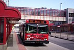
 South Keys station looking northwest | |||||||||||||||||||
| Location | Ottawa, Ontario Canada | ||||||||||||||||||
| Coordinates | 45°21′13″N 75°39′19″W / 45.35361°N 75.65528°WCoordinates: 45°21′13″N 75°39′19″W / 45.35361°N 75.65528°W | ||||||||||||||||||
| Owned by | OC Transpo | ||||||||||||||||||
| Platforms | Centre platform | ||||||||||||||||||
| Tracks | 2 | ||||||||||||||||||
| History | |||||||||||||||||||
| Opening | September 2, 1995 (Transitway) 2023 (LRT) | ||||||||||||||||||
| Services | |||||||||||||||||||
| |||||||||||||||||||
| Future services | |||||||||||||||||||
| |||||||||||||||||||

South Keys station is a stop on Ottawa's transitway system.[1] Operated by OC Transpo, it is last station at the southern end of the Transitway, just north of Hunt Club Road. The station is located in the South Keys neighbourhood of Ottawa at the south end of the South Keys Shopping Centre beside the Cineplex Odeon South Keys Cinemas, between Bank Street and the Airport Parkway. The station was opened to traffic with the southern transitway on September 2, 1995.
OC Transpo bus route 97 continues on the Airport Parkway from Greenboro to the most southern station, Airport station, while other routes such as routes 98 and 99 exit at Hunt Club Road.
Previously, City Council approved the addition of an O-Train station at South Keys (instead of Lester) in conjunction of the expansion of the north–south light rail line. The project was cancelled on December 14, 2006. In 2023, South Keys will reopen as a centre platform, light rail station. It will serve as the transfer point between the Trillium Line and the Airport Link.[2]
Service[]
The following routes serve South Keys as of October 6, 2019:
| O-Train | |
| 98 | Rapid routes |
| 40 11 | Frequent routes |
| 55 173 | Local routes |
| 298 | Connexion routes |
| 406 | 300s: Shopper routes 400s: Event routes 600s: School routes |
|
Additional info:
| |
| Station service | |
|---|---|
| Rapid routes | 97 98 99 |
| Frequent routes | 6 40 90 |
| Local routes | 92 93 96 197 198 199 |
| Connexion routes | 294 299 |
| Shopper routes | 304 |
| Event routes | 452 |
| School routes | 640 644 649 698 |
| Replacement routes | R-2 |
Safety issues[]
This station has a history of safety concerns during the night time hours. There were several incidents involving assaults,[3] swarming[4] and vandalism[5] in the vicinity which prompted some increased safety measures. This station has a night stop which all buses use after 9pm.[6]
References[]
- ^ "South Keys" (PDF). Station Layout. OC Transpo. December 2015. Retrieved 12 March 2016.
- ^ "Trillium Line South Extension". ottawa.ca. November 19, 2019. Retrieved May 4, 2020.
- ^ "Police looking into another south-end personal robbery". CBCnews. 26 November 2013. Retrieved 11 December 2014.
- ^ Bell, Danielle (20 November 2012). "Girls arrested after South Keys robberies". Ottawa Sun. Retrieved 11 December 2014.
- ^ "Two boys charged after dog spray released at transit stop". Ottawa Sun. 3 November 2013. Retrieved 11 December 2014.
- ^ "Night Stop and Safe Stop". OCTranspo. Retrieved 11 December 2014.
OC Transpo services in Ottawa | |||||||||||||||||||
|---|---|---|---|---|---|---|---|---|---|---|---|---|---|---|---|---|---|---|---|
| |||||||||||||||||||
| |||||||||||||||||||
| |||||||||||||||||||
- Railway stations scheduled to open in 2023
- Trillium Line stations
- Line 4 (Ottawa) stations
- 1995 establishments in Ontario
- Transitway (Ottawa) stations