South Wellesley Islands
| South Wellesley Islands Queensland | |
|---|---|
 South Wellesley Islands | |
| Coordinates | 17°00′13″S 139°21′48″E / 17.0037°S 139.3634°ECoordinates: 17°00′13″S 139°21′48″E / 17.0037°S 139.3634°E |
| Population | 0 (2016 census)[1] |
| • Density | 0.000/km2 (0.000/sq mi) |
| Postcode(s) | 4871 |
| Area | 144.2 km2 (55.7 sq mi) |
| Time zone | AEST (UTC+10:00) |
| LGA(s) | Shire of Mornington |
| State electorate(s) | Traeger |
| Federal Division(s) | Kennedy |


The South Wellesley Islands is an island group and locality in the Gulf of Carpentaria within the Shire of Mornington, Queensland, Australia.[2] In the 2016 census, the South Wellesley Islands had a population of 0 people.[1]
Geography[]
The islands are (west to east):
- Allen Island
- Horseshoe Island
- Albinia Island
- Bentinck Island. In 1918, the island was the site of the McKenzie massacre, in which many indigenous inhabitants, including women and children, died.[3][4]
- Fowler Island
- Sweers Island

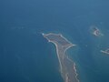
Southern part of Bentinck Island and Albinia Island

Bentinck Island with the Australian continent in the background

the small Fowler Island is located between Seers Island and Bentinck Island

Location of Bentinck Island
Southern part of Sweers Island


History[]
Kayardild (also known as Kaiadilt and Gayadilta) is a language of the Gulf of Carpentaria. The Kayardild language region includes the landscape within the local government boundaries of the Mornington Shire Council.[5]
Sometime around 1916, a man remembered only as McKenzie came to Bentinck Island and set up a sheep run, basing himself on a site at the mouth of the Kurumnbali estuary. He would ride over the island, accompanied by a pack of dogs, and shoot any Kaiadilt man who came within sight; in local memory, he murdered at least 11 people. He also kidnapped and raped native girls. He then moved to Sweers Island, and set up a lime kiln there. The Kaiadilt managed to return to Sweers only on McKenzie's departure. The massacre was only recorded by researchers in the 1980s.[4]
Sweers Island was declared an Aboriginal reserve in 1934. After a cyclonic tidal surge swept the area in 1948, which followed fast on the severe drought that struck in 1946, the Kaiadilt were transferred by missionaries and the Queensland Government to Mornington Island. The uprooting effectively set in place the process of the destruction of both Kaiadilt culture and language since all children were restricted to dormitories, away from their parents and kin, and the transmission of the language and lore was lost. On Mornington Island they lived in a separate zone, in beach humpies facing Bentinck Island. They were looked down on by the Indigenous Lardil people, who denied them access to the fishing grounds. Conditions were so severe that for several years all children were stillborn, creating a gap in the generations. From the late 1960s onwards, the Kaiadilt began to return to their own islands.[citation needed]
References[]
| Wikimedia Commons has media related to South Wellesley Islands. |
- ^ Jump up to: a b Australian Bureau of Statistics (27 June 2017). "South Wellesley Islands (SSC)". 2016 Census QuickStats. Retrieved 20 October 2018.

- ^ "South Wellesley Islands – locality in Shire of Mornington (entry 42537)". Queensland Place Names. Queensland Government. Retrieved 13 November 2019.
- ^ Bruce Elder (1998). Blood on the Wattle: Massacres and maltreatment of Aboriginal Australians since 1788. Page 203 - 206: New Holland Publishers. ISBN 1-86436-410-6.CS1 maint: location (link)
- ^ Jump up to: a b Kelly, Roma; Evans, Nicholas (1985). "The McKenzie massacre on Bentinck Island" (PDF). Aboriginal History. 9 (1). Archived (PDF) from the original on 11 February 2020. Retrieved 13 April 2020.
- ^
 This Wikipedia article incorporates CC-BY-4.0 licensed text from: "Indigenous languages map of Queensland". State Library of Queensland. State Library of Queensland. Retrieved 5 February 2020.
- Islands of Queensland
- North West Queensland
- Gulf of Carpentaria
- Shire of Mornington (Queensland)
- Massacres of ethnic groups
- Localities in Queensland