Sovetsk, Kaliningrad Oblast
Sovetsk
Советск | |
|---|---|
Town | |
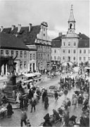
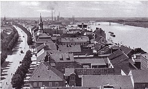
 The old town of Sovetsk, with German-era buildings | |
 Flag  Coat of arms | |
show Location of Sovetsk | |
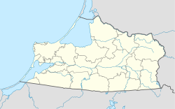 Sovetsk Location of Sovetsk | |
| Coordinates: 55°05′N 21°53′E / 55.083°N 21.883°ECoordinates: 55°05′N 21°53′E / 55.083°N 21.883°E | |
| Country | Russia |
| Federal subject | Kaliningrad Oblast |
| Founded | 1288 |
| Town status since | 1552 |
| Government | |
| • Head | Viktor Smilgin |
| Elevation | 10 m (30 ft) |
| Population | |
| • Total | 41,705 |
| • Estimate (2018)[2] | 39,752 (−4.7%) |
Administrative status | |
| • Subordinated to | town of oblast significance of Sovetsk[3] |
| • Capital of | town of oblast significance of Sovetsk[3] |
Municipal status | |
| • Urban okrug | Sovetsky Urban Okrug[4] |
| • Capital of | Sovetsky Urban Okrug[4] |
| Time zone | UTC+2 (MSK–1 |
| Postal code(s)[6] | 238750 |
| Dialing code(s) | +7 40161 |
| OKTMO ID | 27730000001 |
| Website | mosovetsk |


Sovetsk (Russian: Сове́тск) is a town in Kaliningrad Oblast, Russia, located on the south bank of the Neman River which forms the border with Lithuania. Before 1946, the town was Tilsit in German[7] (Lithuanian: Tilžė; Polish: Tylża) in East Prussia.
Geography[]
Sovetsk lies at the confluence of the Tilse and Neman rivers. Panemunė in Lithuania was formerly a suburb of the town; after Germany's defeat in World War I, the trans-Memel suburb was detached from Tilsit (with the rest of the Klaipėda Region (Memelland), created from the Province of East Prussia) in 1920.
Climate[]
Sovetsk has a borderline oceanic climate (Cfb in the Köppen climate classification) using the −3 °C or 26.6 °F boundary, or a humid continental climate (Dfb) using the 0 °C or 32 °F boundary.
| hideClimate data for Sovetsk | |||||||||||||
|---|---|---|---|---|---|---|---|---|---|---|---|---|---|
| Month | Jan | Feb | Mar | Apr | May | Jun | Jul | Aug | Sep | Oct | Nov | Dec | Year |
| Average high °C (°F) | −0.6 (30.9) |
0.7 (33.3) |
5.4 (41.7) |
12.3 (54.1) |
17.5 (63.5) |
20.2 (68.4) |
22.8 (73.0) |
22 (72) |
17.5 (63.5) |
11.1 (52.0) |
6 (43) |
2.1 (35.8) |
11.4 (52.6) |
| Daily mean °C (°F) | −2.7 (27.1) |
−1.8 (28.8) |
1.8 (35.2) |
7.8 (46.0) |
13.1 (55.6) |
16.4 (61.5) |
19 (66) |
18.3 (64.9) |
14 (57) |
8.4 (47.1) |
4.2 (39.6) |
0.4 (32.7) |
8.2 (46.8) |
| Average low °C (°F) | −5 (23) |
−4.5 (23.9) |
−1.8 (28.8) |
2.9 (37.2) |
8 (46) |
11.8 (53.2) |
14.8 (58.6) |
14.4 (57.9) |
10.5 (50.9) |
5.8 (42.4) |
2.3 (36.1) |
−1.4 (29.5) |
4.8 (40.6) |
| Average precipitation mm (inches) | 59 (2.3) |
50 (2.0) |
51 (2.0) |
46 (1.8) |
56 (2.2) |
75 (3.0) |
95 (3.7) |
83 (3.3) |
65 (2.6) |
68 (2.7) |
60 (2.4) |
57 (2.2) |
765 (30.2) |
| Source: https://en.climate-data.org/asia/russian-federation/kaliningrad/sovetsk-12841/ | |||||||||||||
History[]

Tilsit, which received civic rights from Albert, Duke of Prussia in 1552, developed around a castle of the Teutonic Knights, known as the Schalauer Haus, founded in 1288.
The Treaties of Tilsit were signed here in July 1807, the preliminaries of which were settled by the emperors Alexander I of Russia and Napoleon I of France on a raft moored in the Neman River. This treaty, which created the Kingdom of Westphalia and the Duchy of Warsaw, completed Napoleon's humiliation of the Kingdom of Prussia, when it was deprived of one half of its dominions. Three days before its signing, the Prussian queen Louise (1776–1810) tried to persuade Napoleon in a private conversation to ease his hard conditions on Prussia; though unsuccessful, Louise's effort endeared her to the Prussian people.
Until 1945, a marble tablet marked the house in which King Frederick William III of Prussia and Queen Louise resided. Also, in the former Schenkendorf Platz was a monument to the poet Max von Schenkendorf (1783–1817), a native of Tilsit; a statue of Lenin was erected in its place in 1967.
During the 19th century when the Lithuanian language in Latin characters was banned within the Russian Empire, Tilsit was an important centre for printing Lithuanian books which then were smuggled by Knygnešiai to the Russian-controlled part of Lithuania. In general, Tilsit thrived and was an important Prussian town. By 1900 it had electric tramways and 34,500 inhabitants; a direct railway line linked it to Königsberg and Labiau and steamers docked there daily. According to the Prussian census of 1905, the city of Tilsit had a population of 37,148, of which 96% were Germans and 4% were Lithuanians.[8] The bridge was built in 1907 and rebuilt in 1946. The town was occupied by Russian troops between 26 August 1914 and 12 September 1914 during World War I. The Act of Tilsit was signed here by leaders of the Lietuvininks in 1918.
Hitler visited the town just before World War II, and a photo was taken of him on the famous bridge over the Memel River. Tilsit was occupied by the Red Army on January 20, 1945, and was annexed by the Soviet Union in 1945. The remaining Germans who had not evacuated were subsequently forcibly expelled and replaced with Soviet citizens. The town was renamed Sovetsk in honor of Soviet rule.
Modern Sovetsk has sought to take advantage of Tilsit's tradition of cheese production (Tilsit cheese), but the new name ("Sovetsky cheese") has not inherited its predecessor's reputation.
Since the dissolution of the Soviet Union in 1991, there has been some discussion about the possibility of restoring the town's original name.[9] In 2010, the Kaliningrad Oblast's then-governor Georgy Boos of the ruling United Russia Party proposed restoring the original name and combining the town with the Neman and Slavsk Districts to form a new Tilsit District. Boos emphasized that this move would stimulate development and economic growth, but that it could happen only through a referendum.[10] The idea was opposed by the Communist Party of Russia; in particular, Igor Revin, the Kaliningrad Secretary of the Communist Party, accused Boos and United Russia of Germanophilia.[11]
In April 2007, government restrictions on visits to border areas were tightened, and for foreigners, and Russians living outside the border zone, travel to the Sovetsk and Bagrationovsk areas required advance permission from the Border Guard Service (in some cases up to 30 days beforehand). It was alleged that this procedure slowed the development of these potentially thriving border towns.[12] In June 2012, these restrictions were lifted (the only restricted area is the Neman river shoreline), which gave a boost to local and international tourism.
Administrative and municipal status[]
Within the framework of administrative divisions, it is incorporated as the town of oblast significance of Sovetsk—an administrative unit with the status equal to that of the districts.[3] As a municipal division, the town of oblast significance of Sovetsk is incorporated as Sovetsky Urban Okrug.[4]
Architecture[]
Many of the town's buildings were destroyed during World War II. However, the old town centre still includes several German buildings, including those of Jugendstil design. The Queen Louise Bridge, now connecting the town to Panemunė/Übermemel in Lithuania, retains an arch – all that is left of a more complex pre-war bridge structure built in 1907. The carved relief portrait of Queen Louise above the arch still exists; however, the German inscription "KÖNIGIN LUISE-BRÜCKE" was removed after the Soviets took over the town.
Historical population[]
Ethnic composition in 2010:[citation needed]
- Russians: 86.7%
- Ukrainians: 3.5%
- Lithuanians: 3.3%
- Belarusians: 2.7%
Twin towns – sister cities[]
 Bełchatów, Poland
- Iława (rural gmina), Poland
 Kiel, Germany
- Lidzbark Warmiński, Poland
 Pagėgiai, Lithuania
 Považská Bystrica, Slovakia
- Šilalė, Lithuania
- Tauragė, Lithuania
Notable people[]


- Daniel Klein (1609–1666), Lithuanian pastor and grammarian
- Johann Christian Jacobi (1719–1784), German oboist
- Max von Schenkendorf (1783–1817), German poet and author
- Franz Meyen (1804–1840), German botanist
- Hans Victor von Unruh (1806–1886), German politician and technician
- Wilhelm Voigt (1849–1922), the inspiration for The Captain of Köpenick
- Margarete Poehlmann (1856–1923), German educator and politician, first woman to speak in a Prussian parliament
- Gustaf Kossinna or Kossina (1858–1931), archaeologist
- Johanna Wolff (1858–1943), German author
- Max Scherwinsky (1859–1909) German-born architect working mainly in Riga, Latvia
- Emil Wiechert (1861–1928), German geophysicist
- Raphael Friedeberg (1863–1940), German physician and politician
- Max Gülstorff (1882–1947), German actor
- Carl Brinkmann (1885–1954), German sociologist and economist
- Franz Scheidies (1890–1942) general in the Wehrmacht during WWII
- Walter Weiß (1890–1967), German general during WWII.
- Friedrich Schröder Sonnenstern (1892–1982), Illustrator
- Dick Shikat (1897–1968) German professional wrestler and World Heavyweight Champion
- Frank Wisbar (1899–1967) German director
- Karl Hermann Martell (1906–1966), German actor
- Franz Abromeit (1907–1964), SS officer, Reichssicherheitshauptamt (Judenreferent)
- Joachim Sadrozinski (1907–1944), officer and resistance fighter
- Erna Dorn (1911–1953) victim of injustice in the German Democratic Republic
- Siegfried Graetschus (1916–1943), SS-Oberscharführer, killed during revolt in Sobibor extermination camp
- Johannes Bobrowski (1917–1965), German writer
- Werner Abrolat (1924–1997), German actor
- Gunter Wyszecki (1925–1985), German-Canadian physicist
- Armin Mueller-Stahl (born 1930), German actor, honorary citizen since 8 December 2011[16]
- Sabine Bethmann (born 1931), German actress
- Jürgen Kurbjuhn (1940–2014), football player
- Klaus-Dieter Sieloff (1942–2011), football player
- John Kay (born 1944), lead singer of the late 1960s rock band Steppenwolf
- Edgar Froese (1944–2015), German founder and leader of the electronic music group Tangerine Dream
- Victor Ivrii (born 1949) a Soviet, Canadian mathematician
- Andrei Sosnitskiy (born 1962) a Belarusian professional football coach and a former player
Gallery[]

Coat of arms of Tilsit (1905)
1930
Old view of Tilsit

Lithuanian Church, between 1910–1930

Pre-war German-era houses in Sovetsk/Tilsit

The Queen Louise bridge


Popular culture[]
The town is the location of a scene in Leo Tolstoy's War and Peace (Book Two Part Two Chapter 21).[17] Tilsit is the setting for part of the 1939 film "The Journey to Tilsit".
References[]
Notes[]
- ^ Jump up to: a b Russian Federal State Statistics Service (2011). Всероссийская перепись населения 2010 года. Том 1 [2010 All-Russian Population Census, vol. 1]. Всероссийская перепись населения 2010 года [2010 All-Russia Population Census] (in Russian). Federal State Statistics Service.
- ^ "26. Численность постоянного населения Российской Федерации по муниципальным образованиям на 1 января 2018 года". Federal State Statistics Service. Retrieved January 23, 2019.
- ^ Jump up to: a b c Resolution #639
- ^ Jump up to: a b c Law #376
- ^ "Об исчислении времени". Официальный интернет-портал правовой информации (in Russian). June 3, 2011. Retrieved January 19, 2019.
- ^ Почта России. Информационно-вычислительный центр ОАСУ РПО. (Russian Post). Поиск объектов почтовой связи (Postal Objects Search) (in Russian)
- ^ M. Kaemmerer (2004). Ortsnamenverzeichnis der Ortschaften jenseits von Oder u. Neiße (in German). ISBN 3-7921-0368-0.
- ^ Belzyt, Leszek (1998). Sprachliche Minderheiten im preussischen Staat: 1815 - 1914 ; die preußische Sprachenstatistik in Bearbeitung und Kommentar. Marburg: Herder-Inst. ISBN 978-3-87969-267-5.
- ^ Karabeshkin, Leonid; Wellmann, Christian (2004). The Russian Domestic Debate on Kaliningrad: Integrity, Identity and Economy. Münster: LIT Verlag. p. 35. ISBN 9783825879525.
- ^ На карте Калининградской области появится Тильзитский район?. Komsomolskaya Pravda (in Russian). March 24, 2010. Retrieved October 6, 2017.
- ^ Stolyarov, Bulat (March 25, 2010). Переименовать город ��орого, нужно четко понимать зачем. Snob.ru (in Russian). Retrieved October 6, 2017.
- ^ PONARS Eurasia Memo #16. "EU–Russian Border Security. Stereotypes and Realities." (PDF). (55 Kb])
- ^ Всесоюзная перепись населения 1989 г. Численность наличного населения союзных и автономных республик, автономных областей и округов, краёв, областей, районов, городских поселений и сёл-райцентров [All Union Population Census of 1989: Present Population of Union and Autonomous Republics, Autonomous Oblasts and Okrugs, Krais, Oblasts, Districts, Urban Settlements, and Villages Serving as District Administrative Centers]. Всесоюзная перепись населения 1989 года [All-Union Population Census of 1989] (in Russian). Институт демографии Национального исследовательского университета: Высшая школа экономики [Institute of Demography at the National Research University: Higher School of Economics]. 1989 – via Demoscope Weekly.
- ^ Russian Federal State Statistics Service (May 21, 2004). Численность населения России, субъектов Российской Федерации в составе федеральных округов, районов, городских поселений, сельских населённых пунктов – районных центров и сельских населённых пунктов с населением 3 тысячи и более человек [Population of Russia, Its Federal Districts, Federal Subjects, Districts, Urban Localities, Rural Localities—Administrative Centers, and Rural Localities with Population of Over 3,000] (XLS). Всероссийская перепись населения 2002 года [All-Russia Population Census of 2002] (in Russian).
- ^ "Наши партнеры". sovetsk.gov39.ru (in Russian). Sovetsk. Retrieved February 6, 2020.
- ^ Armin Mueller-Stahl Ehrenbürger seiner Heimatstadt Berliner Zeitung, 8 December 2011 (in German)
- ^ Tolstoy, Leo (1949). War and Peace. Garden City: International Collectors Library. pp. 204, 235.
Sources[]
- Правительство Калининградской области. Постановление №640 от 30 августа 2011 г. «Об утверждении реестра объектов административно-территориального деления Калининградской области», в ред. Постановления №877 от 21 ноября 2011 г «О внесении изменения в Постановление Правительства Калининградской области от 30 августа 2011 г. №640». Вступил в силу со дня официального опубликования. Опубликован: "Калининградская правда" (вкладыш "Официально"), №170, 15 сентября 2011 г. (Government of Kaliningrad Oblast. Resolution #640 of August 30, 2011 On the Adoption of the Registry of the Objects of the Administrative-Territorial Divisions of Kaliningrad Oblast, as amended by the Resolution #877 of November 21, 2011 On Amending the Resolution of the Government of Kaliningrad Oblast #640 of August 30, 2011. Effective as of the day of the official publication.).
- Калининградская областная Дума. Закон №376 от 31 марта 2004 г. «О наделении муниципального образования "Город Советск" статусом городского округа», в ред. Закона №370 от 1 июля 2009 г «О составе территорий муниципальных образований Калининградской области». Вступил в силу с момента официального опубликования. Опубликован: "Российская газета" ("Запад России"), №88, 27 апреля 2004 г. (Kaliningrad Oblast Duma. Law #376 of March 31, 2004 On Granting the Urban Okrug Status to the Municipal Formation of the "Town of Sovetsk", as amended by the Law #370 of July 1, 2009 On the Composition of the Territories of the Municipal Formations of Kaliningrad Oblast. Effective as of the moment of the official publication.).
- Northern Germany by Karl Baedeker, 14th revised edition, London, 1904, p. 178.
- This article incorporates text from a publication now in the public domain: Chisholm, Hugh, ed. (1911). "Tilsit". Encyclopædia Britannica (11th ed.). Cambridge University Press.
| show Authority control |
|---|
- Cities and towns in Kaliningrad Oblast
- Castles in Russia
- Lithuania–Russia border crossings
- 1552 establishments in Europe