Baltiysk
Baltiysk
Балтийск | |
|---|---|
Town[1] | |
 Aerial view of Baltiysk | |
 Coat of arms | |
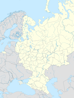
show Location of Baltiysk | |
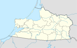 Baltiysk Location of Baltiysk | |
| Coordinates: 54°39′N 19°55′E / 54.650°N 19.917°ECoordinates: 54°39′N 19°55′E / 54.650°N 19.917°E | |
| Country | Russia |
| Federal subject | Kaliningrad Oblast[1] |
| Administrative district | Baltiysky District[1] |
| Town of district significance | Baltiysk[1] |
| Founded | 13th century |
| Town status since | 1725 |
| Government | |
| • Head | Maksim Brychuk |
| Elevation | 10 m (30 ft) |
| Population | |
| • Total | 32,697 |
| • Estimate (2018)[3] | 33,317 (+1.9%) |
Administrative status | |
| • Capital of | Baltiysky District[1], town of district significance of Baltiysk[1] |
Municipal status | |
| • Municipal district | Baltiysky Municipal District[4] |
| • Urban settlement | Baltiyskoye Urban Settlement[4] |
| • Capital of | Baltiysky Municipal District[4], Baltiyskoye Urban Settlement[4] |
| Time zone | UTC+2 (MSK–1 |
| Postal code(s)[6] | 238520–238522, 238525, 238527, 238528 |
| Dialing code(s) | +7 40145 |
| OKTMO ID | 27605101001 |
| Website | балтийск39 |


Baltiysk (Russian: Балти́йск), prior to 1946 known by its German name Pillau[7] (Polish: Piława; Lithuanian: Piliava; Yiddish: פּילאַווע, Pilave[8]), is a seaport town and the administrative center of Baltiysky District in Kaliningrad Oblast, Russia, located on the northern part of the Vistula Spit, on the shore of the Strait of Baltiysk separating the Vistula Lagoon from Gdańsk Bay. Population: 32,697 (2010 Census);[2] 33,252 (2002 Census);[9] 27,070 (1989 Census).[10]
Baltiysk, the westernmost town in Russia, is a major base of the Russian Navy's Baltic Fleet and is a ferry-port on the[which?] route to St. Petersburg.
History[]
Old Prussian village[]
Baltiysk was originally the site of an Old Prussian fishing village that was established on the coast of the Vistula Spit at some point in the 13th century. The village was named as "Pile" or "Pil" in several documents, possibly taking its name from pils the Old Prussian language word for fort.[citation needed] It was eventually conquered by the Teutonic Knights, with the name evolving into the German form of Pillau. In 1497, a storm surge dug a new gat in front of the village, and another large storm created the navigable Strait of Baltiysk through the gat on September 10, 1510. This fostered the growth of Pillau into an important port of the Duchy of Prussia, and a blockhouse was constructed in 1537, followed by a system of storehouses in 1543, and the earliest fortifications in 1550. During the Thirty Years' War, the harbor was occupied by Sweden in the aftermath of their victory over the Polish–Lithuanian Commonwealth, and King Gustavus Adolphus landed there with his reinforcements in May 1626. After the ceasefire of Altmark in 1629, the Swedes retained Pillau and set out upgrading its fortifications, constructing a star fort which remains one of the town's landmarks. In 1635, the citizens of Pillau paid the ransom of 10,000 thalers, whereupon Swedish forces handed over the settlement to the Elector of Brandenburg.
Prussian town[]

By the end of the 17th century, Pillau had expanded considerably, and a lighthouse and a stone church were built. Peter the Great, the Tsar of Russia, visited Pillau on three occasions, the first being in 1697 in connection with his Grand Embassy to Western Europe. A statue of the Peter the Great currently stands next to the lighthouse. After Pillau was granted town privileges in 1725, the Baroque-style town hall was constructed and inaugurated in May 1745, but was destroyed at the end of World War II. Russian forces occupied the town during the Seven Years' War and built a small Orthodox church there, with the event commemorated by the equestrian statue of Empress Elizabeth, unveiled in 2004. In June 1807, Pillau was stormed by Napoleon's Grande Armée during the Napoleonic Wars, although no outstanding events took place during the rest of the 19th century. Records of a Scottish "colony" established in Pillau in 1815 appeared in an 1890 publication, although their authenticity is questionable. The lighthouse was built up to a height of 31.38 meters (103.0 ft) and the entire fortress was updated and rebuilt by the Prussians in 1871.
The importance of Pillau declined from November 15, 1901, when a was opened linking the Vistula Lagoon near Zimmerbude (now Svetly) to Königsberg. Pillau's economy was heavily based on large shipping vessels being forced to dock in the town due to the shallow depth of the lagoon near Königsberg, the capital and the largest city of East Prussia, and the goods would then be transported from Pillau to Königsberg by other means. Constructed at a huge cost of thirteen million marks, the canal allowed vessels of a 21 feet (6.4 m) draught to moor alongside the city or to sail directly to Königsberg without stopping at Pillau, causing a serious decline to the town's economy.
World War II[]

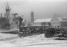
During World War II, Pillau had a U-boat training facility, and on April 16, 1945, the German submarine U-78 was sunk by Red Army artillery fire while she was docked near the electricity supply pier in Pillau port, and was the only U-boat to be ever sunk by land-based forces in World War II. As the Red Army entered East Prussia, more than 450,000 refugees were ferried from Pillau to central and western Germany, with the town eventually being captured by Soviets on April 25, 1945.
Modern Baltiysk[]
After the war, Pillau was included in the northern part of East Prussia passed to the Soviet Union that became Kaliningrad Oblast, and the German inhabitants were expelled. During the Russification campaign, the town's name was changed to Baltiysk in 1946.[11]
In 1952, the Soviet authorities inaugurated a naval base for the Baltic Fleet of the Soviet Navy at Baltiysk, and as a result it became a closed town with access forbidden to foreigners or those without a permit. During the Cold War it was served by the Baltiysk Air Base. The town, along with Kaliningrad, remains one of only two year-round ice-free ports along the Baltic Sea coastline available to Russia.
In 2019, on a wave of anti-Western sentiment following Russia's annexation of Crimea, there were calls to change the town's German-era coat of arms, which features a sturgeon wearing the crown of King Frederick William I of Prussia. The historic arms had been granted to the town, then known as Pillau, in 1725.[12]
Administrative and municipal status[]
Within the framework of administrative divisions, Baltiysk serves as the administrative center of Baltiysky District.[1] As an administrative division, it is, together with two rural localities, incorporated within Baltiysky District as the town of district significance of Baltiysk.[1] As a municipal division, the town of district significance of Baltiysk is incorporated within Baltiysky Municipal District as Baltiyskoye Urban Settlement.[4]
Climate[]
Baltiysk has a temperate oceanic climate (Köppen Cfb borders on Dfb).[13] Winters are cold to mild, while summers are warm. In July and August, the warmest season, high temperatures average 21 °C (70 °F) and low temperatures average 15 °C (59 °F). In January and February, the coldest season, high temperatures average 3 °C (37 °F) with low temperatures averaging −2 °C (28 °F).
| hideClimate data for Baltiysk | |||||||||||||
|---|---|---|---|---|---|---|---|---|---|---|---|---|---|
| Month | Jan | Feb | Mar | Apr | May | Jun | Jul | Aug | Sep | Oct | Nov | Dec | Year |
| Record high °C (°F) | 14.5 (58.1) |
17.1 (62.8) |
14.9 (58.8) |
25.0 (77.0) |
27.1 (80.8) |
29.4 (84.9) |
31.7 (89.1) |
31.3 (88.3) |
26.7 (80.1) |
22.6 (72.7) |
17.1 (62.8) |
17.0 (62.6) |
31.7 (89.1) |
| Average high °C (°F) | 2.5 (36.5) |
2.5 (36.5) |
4.6 (40.3) |
9.7 (49.5) |
14.9 (58.8) |
17.8 (64.0) |
20.6 (69.1) |
21.0 (69.8) |
16.8 (62.2) |
12.4 (54.3) |
6.4 (43.5) |
3.5 (38.3) |
11.1 (52.0) |
| Daily mean °C (°F) | 0.3 (32.5) |
0.4 (32.7) |
2.5 (36.5) |
7.0 (44.6) |
11.7 (53.1) |
15.0 (59.0) |
17.9 (64.2) |
18.4 (65.1) |
14.4 (57.9) |
10.1 (50.2) |
4.6 (40.3) |
1.4 (34.5) |
8.7 (47.7) |
| Average low °C (°F) | −1.8 (28.8) |
−1.6 (29.1) |
0.3 (32.5) |
4.0 (39.2) |
8.2 (46.8) |
11.8 (53.2) |
14.8 (58.6) |
15.6 (60.1) |
12.1 (53.8) |
8.1 (46.6) |
2.9 (37.2) |
−0.4 (31.3) |
6.2 (43.2) |
| Record low °C (°F) | −20.8 (−5.4) |
−17.6 (0.3) |
−12.9 (8.8) |
−4.0 (24.8) |
−0.2 (31.6) |
1.4 (34.5) |
7.8 (46.0) |
8.1 (46.6) |
4.3 (39.7) |
−1.4 (29.5) |
−8.8 (16.2) |
−14.8 (5.4) |
−20.8 (−5.4) |
| Average precipitation mm (inches) | 65 (2.6) |
54 (2.1) |
50 (2.0) |
41 (1.6) |
53 (2.1) |
71 (2.8) |
78 (3.1) |
69 (2.7) |
73 (2.9) |
62 (2.4) |
66 (2.6) |
73 (2.9) |
752 (29.6) |
| Source: Kaliningrad-meteo.ru[14] | |||||||||||||
Landmarks[]
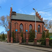
Historical buildings in and around the town include the pentagonal , founded by the Swedes in 1626, completed by the Prussians in 1670, renovated in 1870, and currently holding a naval museum; the ruins of the 13th-century Lochstadt Castle; a maze of 19th-century naval fortifications; the Naval Cathedral of St. George (1866); the 32-meter (105 ft) Expressionist observation tower (1932); the Gothic Revival building of the Baltic Fleet Museum (1903); and an elegant lighthouse, dating from 1813-1816. A stone cross, erected in 1830 to commemorate the supposed spot of St. Adalbert of Prague's martyrdom, was destroyed by the Soviets and restored a millennium after the event, in 1997.
Notable people[]
- Karl Heinrich Barth (1847–1922), German pianist
- Otto Dempwolff (1871–1938), German linguist and anthropologist
- Fritz Gajewski (1885-1965) a German businessman with IG Farben
- Renate Garisch-Culmberger (born 1939), East German athlete
- Manfred Schaefer (born 1943) a former association football defender
- Grigoriy Korchmar (born 1947) a Russian composer and pianist.
International relations[]

Twin towns and sister cities[]
Baltiysk is twinned with:
References[]
Notes[]
- ^ Jump up to: a b c d e f g h Resolution #640
- ^ Jump up to: a b Russian Federal State Statistics Service (2011). Всероссийская перепись населения 2010 года. Том 1 [2010 All-Russian Population Census, vol. 1]. Всероссийская перепись населения 2010 года [2010 All-Russia Population Census] (in Russian). Federal State Statistics Service.
- ^ "26. Численность постоянного населения Российской Федерации по муниципальным образованиям на 1 января 2018 года". Federal State Statistics Service. Retrieved January 23, 2019.
- ^ Jump up to: a b c d e Law #274
- ^ "Об исчислении времени". Официальный интернет-портал правовой информации (in Russian). June 3, 2011. Retrieved January 19, 2019.
- ^ Почта России. Информационно-вычислительный центр ОАСУ РПО. (Russian Post). Поиск объектов почтовой связи (Postal Objects Search) (in Russian)
- ^ Kaemmerer, Margarete (2004). Ortsnamenverzeichnis der Ortschaften jenseits von Oder u. Neiße (in German). p. 125. ISBN 3-7921-0368-0.
- ^ פּילאַווע, Yiddishland https://www.yivo.org/yiddishland-topo
- ^ Russian Federal State Statistics Service (May 21, 2004). Численность населения России, субъектов Российской Федерации в составе федеральных округов, районов, городских поселений, сельских населённых пунктов – районных центров и сельских населённых пунктов с населением 3 тысячи и более человек [Population of Russia, Its Federal Districts, Federal Subjects, Districts, Urban Localities, Rural Localities—Administrative Centers, and Rural Localities with Population of Over 3,000] (XLS). Всероссийская перепись населения 2002 года [All-Russia Population Census of 2002] (in Russian).
- ^ Всесоюзная перепись населения 1989 г. Численность наличного населения союзных и автономных республик, автономных областей и округов, краёв, областей, районов, городских поселений и сёл-райцентров [All Union Population Census of 1989: Present Population of Union and Autonomous Republics, Autonomous Oblasts and Okrugs, Krais, Oblasts, Districts, Urban Settlements, and Villages Serving as District Administrative Centers]. Всесоюзная перепись населения 1989 года [All-Union Population Census of 1989] (in Russian). Институт демографии Национального исследовательского университета: Высшая школа экономики [Institute of Demography at the National Research University: Higher School of Economics]. 1989 – via Demoscope Weekly.
- ^ Энциклопедия Города России. Moscow: Большая Российская Энциклопедия. 2003. p. 36. ISBN 5-7107-7399-9.
- ^ Russian court finds illegal German coat of arms of town in far western exclave
- ^ Weatherbase Climate Summary
- ^ "Kaliningrad-meteo.ru". Retrieved April 17, 2012.[permanent dead link]
- ^ "Elbląg - Podstrony / Miasta partnerskie". Elbląski Dziennik Internetowy (in Polish). Archived from the original on March 15, 2011. Retrieved August 1, 2013.
- ^ "Elbląg - Miasta partnerskie". Elbląg.net (in Polish). Retrieved August 1, 2013.
Sources[]
- Правительство Калининградской области. Постановление №640 от 30 августа 2011 г. «Об утверждении реестра объектов административно-территориального деления Калининградской области», в ред. Постановления №877 от 21 ноября 2011 г «О внесении изменения в Постановление Правительства Калининградской области от 30 августа 2011 г. №640». Вступил в силу со дня официального опубликования. Опубликован: "Калининградская правда" (вкладыш "Официально"), №170, 15 сентября 2011 г. (Government of Kaliningrad Oblast. Resolution #640 of August 30, 2011 On the Adoption of the Registry of the Objects of the Administrative-Territorial Divisions of Kaliningrad Oblast, as amended by the Resolution #877 of November 21, 2011 On Amending the Resolution of the Government of Kaliningrad Oblast #640 of August 30, 2011. Effective as of the day of the official publication.).
- Калининградская областная Дума. Закон №274 от 3 июля 2008 г «Об организации местного самоуправления на территории муниципального образования "Балтийский городской округ"», в ред. Закона №370 от 1 июля 2009 г «О составе территорий муниципальных образований Калининградской области». Вступил в силу со дня официального опубликования. Опубликован: "Калининградская правда", №124, 11 июля 2008 г. (Kaliningrad Oblast Duma. Law #274 of July 3, 2008 On the Organization of the Local Self-Government on the Territory of the Municipal Formation of "Baltiysky Urban Okrug", as amended by the Law #370 of July 1, 2009 On the Composition of the Territories of the Municipal Formations of Kaliningrad Oblast. Effective as of the day of the official publication.).
- Baedeker, Karl, Northern Germany, 14th revised (English-language) edition, Leipzig, London, and New York, 1904.
External links[]
- Official website of Baltiysk (in Russian)
- Information site of Baltiysk (in Russian)
- Directory of organizations in Baltiysk (in Russian)
- Winter trip to Baltiysk

| show Authority control |
|---|
- Baltic Fleet
- Cities and towns in Kaliningrad Oblast
- East Prussia
- Populated coastal places in Russia
- Russian and Soviet Navy bases
- Germany–Soviet Union relations
- Port cities and towns of the Baltic Sea
- Castles of the Teutonic Knights