Stiens
Stiens | |
|---|---|
Village | |
 St Vitus' Church | |
 Location in (former) Leeuwarderadeel municipality | |
 Stiens Location in the Netherlands | |
| Coordinates: Coordinates: 53°15′39″N 5°45′27″E / 53.26083°N 5.75750°E | |
| Country | |
| Province | |
| Municipality | |
| Population (2017) | |
| • Total | 7,545 |
| Time zone | UTC+1 (CET) |
| • Summer (DST) | UTC+2 (CEST) |
| Postal code | 9051 |
| Telephone area | 058 |

Stiens is a town in the municipality of Leeuwarden, Netherlands. As of January 2017, the municipality has a population of about 7,545.[1]
History[]
Before 2018, the town was part of the Leeuwarderadeel municipality. The town hall of the municipality was located in Stiens.
Railways[]
Stiens was the main station on the North Friesland Railway. It opened in April 1901, with a branch to Harlingen opening in stages between December 1902 and May 1904. Closures of the railway include the following
- Direct service to Franeker in October 1933;
- Direct service to Harlingen in May 1935 and freight in January 1938;
- All other passenger services ceased in July 1936, but were reopened as far as Tzummarum and Dokkum-Aalsum in May 1940;
- The passenger service to Dokkum-Aalsum closed again in December 1940 and then it became permanently closed in October 1942;
- The final freight service from Stiens to Leeuwarden closed in 1997.
Windmills[]
There are three windmills in Stiens, including De Hoop, De Kleine Molen, and De Steenhuistermolen.
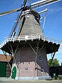
De Hoop
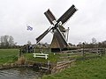
De Kleine Molen

Steenhuistermolen


Notable people[]
- Abe Bonnema (1926-2001), architect
- Piet Dankert (1934-2003), politician
- Pieter Jelles Troelstra (1860-1930), politician
References[]
- ^ Kerncijfers wijken en buurten 2017 - CBS Statline
External links[]
![]() Media related to Stiens at Wikimedia Commons
Media related to Stiens at Wikimedia Commons
This Friesland location article is a stub. You can help Wikipedia by . |
Categories:
- Leeuwarden
- Populated places in Friesland
- Friesland geography stubs